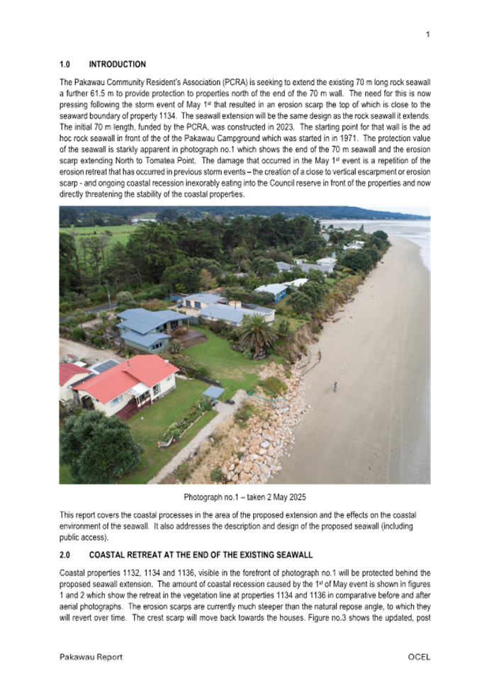
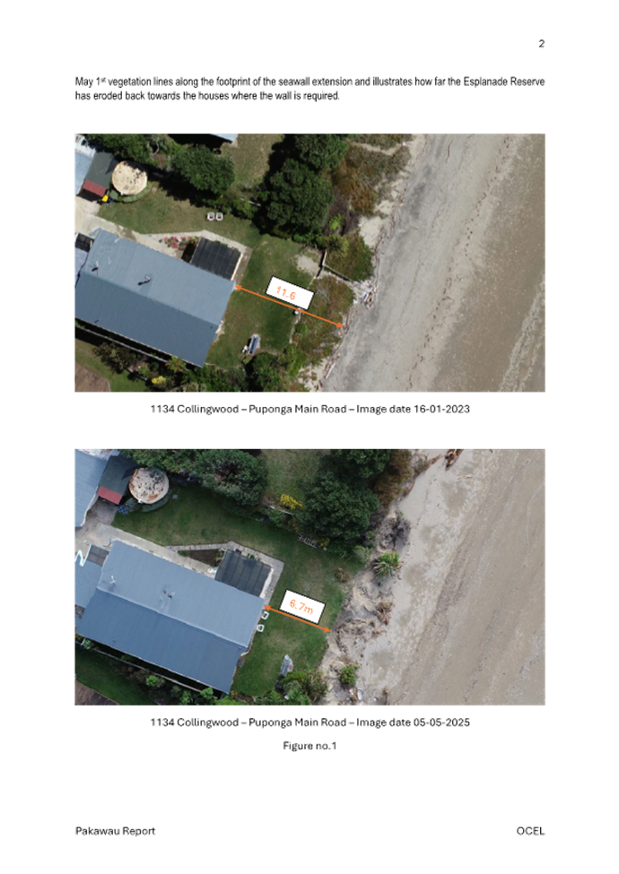
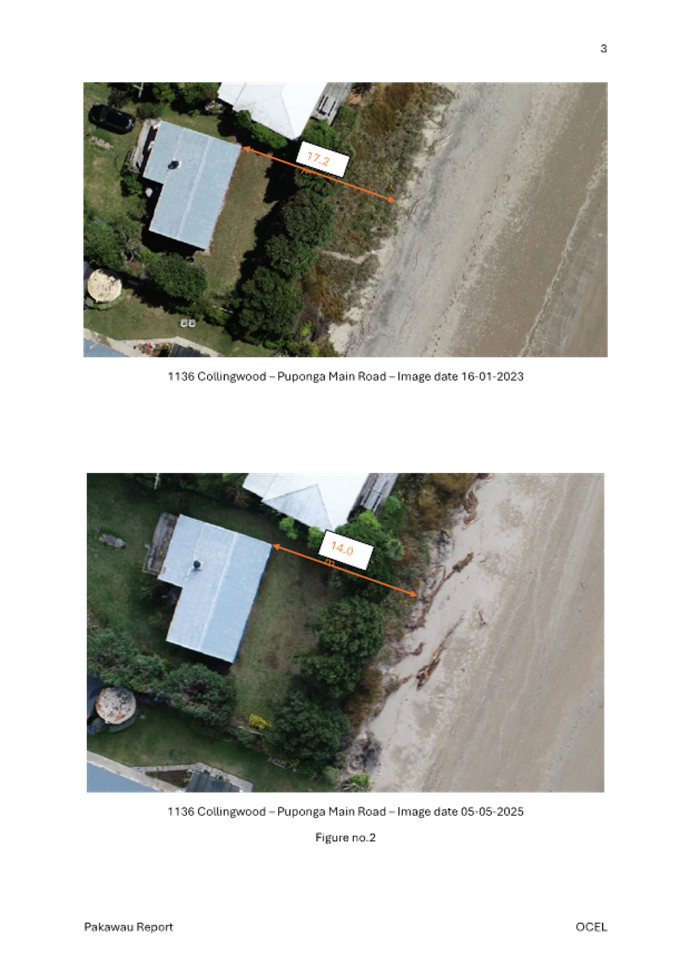
Notice
is given that an ordinary meeting of the Tasman District Council will be held
on:
|
Date:
Time:
Meeting
Room:
Venue:
Zoom
conference link:
Meeting ID:
Meeting Passcode:
|
Thursday 11 September 2025
9.30am
Tasman Council Chamber
189 Queen Street, Richmond
https://us02web.zoom.us/j/84053522970?
840 5352 2970
947408
|
|
Tasman
District Council
Kaunihera
Katoa
AGENDA
|
MEMBERSHIP
|
Mayor
|
Mayor T King
|
|
|
Deputy Mayor
|
Deputy Mayor S Bryant
|
|
|
Councillors
|
Councillor C Butler
|
Councillor M Kininmonth
|
|
|
Councillor G Daikee
|
Councillor C Mackenzie
|
|
|
Councillor B Dowler
|
Councillor K Maling
|
|
|
Councillor J Ellis
|
Councillor B Maru
|
|
|
Councillor M Greening
|
Councillor D Shallcrass
|
|
|
Councillor C Hill
|
Councillor T Walker
|
(Quorum 7 members)
|
|
|
Contact Telephone: 03 543 8400
Email: Robyn.Scherer@tasman.govt.nz
Website: www.tasman.govt.nz
|
AGENDA
1 Opening, Welcome, KARAKIA
2 Apologies
and Leave of Absence
|
Recommendation
That apologies be accepted.
|
3 Public
Forum
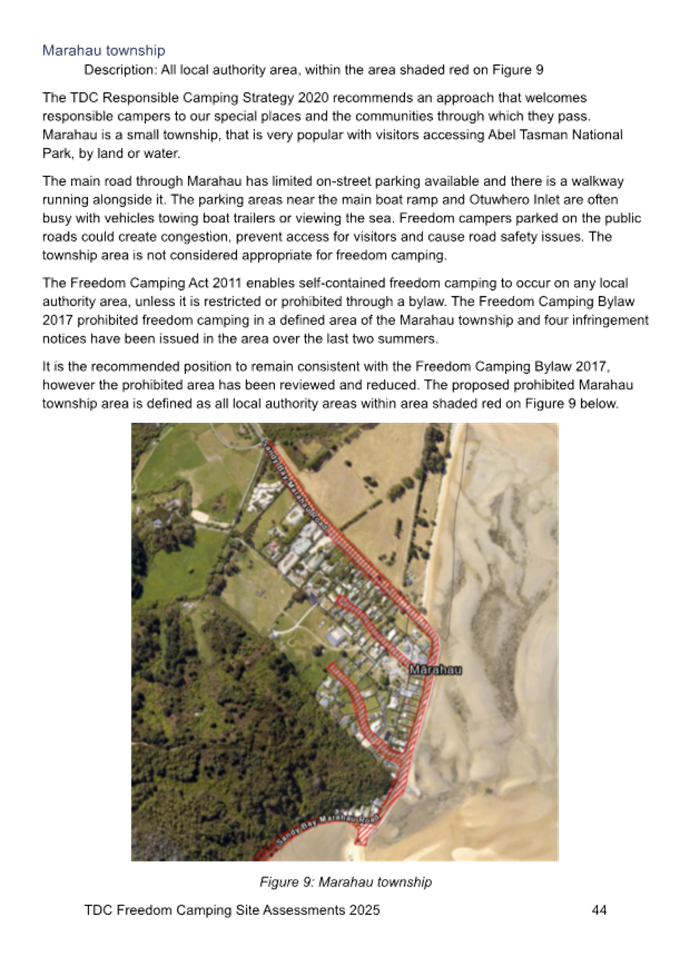
3.1 Pākawau
Community Residents Association.......................................................... 5
3.2 Pākawau
Beach Rock Wall..................................................................................... 6
3.3 Motueka
Masterplan................................................................................................ 7
3.4 Tapawera
Community Hub...................................................................................... 8
4 Declarations
of Interest
5 LATE
ITEMS
6 Confirmation
of minutes
|
That the minutes of
the Tasman District Council meeting held on Thursday, 31 July 2025 be
confirmed as a true and correct record of the meeting.
|
|
That the
minutes of the Tasman District Council meeting held on Thursday, 14 August
2025, be confirmed as a true and correct record of the meeting.
|
|
That the confidential
minutes of the Tasman District Council meeting held on Thursday,
31 July 2025, be confirmed as a true and correct record of the meeting.
|
7 Reports
7.1 Awaroa
Seawall - Landowner Approval.................................................................. 9
7.2 Pakawau
Seawall - Landowner Approval.............................................................. 44
7.3 Recommendation
from the Control of Alcohol in Public Places Bylaw
Hearing and Deliberations Panel........................................................................... 86
7.4 Recommendation
from the Responsible Camping Bylaw Hearing and Deliberations Panel............................................................................................................................. 121
7.5 Temporary
Road Closures.................................................................................. 216
7.6 Amendment
to the Tasman District Council Traffic Control Devices Register
and Traffic Control Bylaw................................................................................... 224
7.7 Eves
Valley Landfill Road Stopping.................................................................... 240
7.8 Selection
of the Site for the New Wakefield Community Hub............................. 248
7.9 Confirmation
of the Location for the new Tapawera Community Hub................ 252
7.10 June/July
2025 Two Weather Events - Recovery Update.................................. 260
7.11 Recommendation
from the Nelson Tasman Regional Landfill Business Unit - Annual Report
2024/2025............................................................................................................ 269
7.12 Recommendation
from the Nelson Tasman Regionsl Landfill Business Unit - Class 3 Contaminated
Soil Graduated Fee Update......................................................... 270
7.13 Recommendation
from the Nelson Tasman Regional Landfill Business Unit - Draft Business Plan
2026/2027.................................................................................................... 271
7.14 Chief
Executive Officer Update........................................................................... 273
8 Confidential
Session
8.1 Procedural
motion to exclude the public............................................................. 275
8.2 Richmond
Aquatic Centre - Procurement of Management and Operations Agreement Report.................................................................................................................. 275
8.3 Motueka
Property Update - Former Motueka Library Building, Laura Ingram Building,
Motueka Service Centre and Hickmott Place Carpark........................................ 275
8.4 Review
of Property Holding - Motueka................................................................ 275
8.5 Motueka
Community Pool Project Update.......................................................... 276
8.6 Chief
Executive Officer Remuneration Review 2025/26..................................... 277
9 CLOSING
KARAKIA
3 Public
Forum
3.1
Pākawau
Community Residents Association
|
Report
To:
|
Tasman
District Council
|
|
Meeting
Date:
|
11
September 2025
|
|
Report
Number:
|
RCN25-09-1
|
1. Public
Forum / Te Matapaki Tūmatanui
Hugh Gully will speak in public forum on
behalf of the Pākawau Community Residents Association regarding the
application for construction of a rock wall at Pākawau.
Nil
3.2 Pākawau Beach Rock Wall
|
Report
To:
|
Tasman
District Council
|
|
Meeting
Date:
|
11
September 2025
|
|
Report
Number:
|
RCN25-09-2
|
1. Public
Forum / Te Matapaki Tūmatanui
Lisa Alexander will speak in public forum
regarding the Pākawau Beach rock wall.
Nil
3.3 Motueka Masterplan
|
Report
To:
|
Tasman
District Council
|
|
Meeting
Date:
|
11
September 2025
|
|
Report
Number:
|
RCN25-09-3
|
1. Public
Forum / Te Matapaki Tūmatanui
Keith Griffiths will speak on behalf of
Seaview Heights in public forum regarding the Motueka Masterplan.
Nil
3.4 Tapawera Community Hub
|
Report
To:
|
Tasman
District Council
|
|
Meeting
Date:
|
11
September 2025
|
|
Report
Number:
|
RCN25-09-4
|
1. Public
Forum / Te Matapaki Tūmatanui
Phoebe Quinlivan will speak in public forum
on behalf of Tapawera Connect regarding the Tapawera Community Hub.
Nil
7 Reports
7.1
Awaroa Seawall -
Landowner Approval
Decision Required
|
Report
To:
|
Tasman
District Council
|
|
Meeting
Date:
|
11
September 2025
|
|
Report
Author:
|
Grant
Reburn, Reserves and Facilities Manager
|
|
Report
Authorisers:
|
Richard
Kirby, Group Manager - Community Infrastructure
|
|
Report
Number:
|
RCN25-09-5
|
1. Purpose
of the Report / Te Take mō te Pūrongo
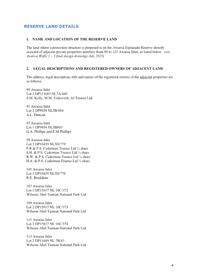
1.1 The purpose of this report is
for the Council, as landowner, to consider giving consent for a coastal
protection structure (seawall) to be constructed over an area of the Awaroa
Inlet Local Purpose (Esplanade) Reserve (the Reserve).
1.2 This
report assesses an application from several property owners at Awaroa Inlet
against the criteria set out in the Tasman District Council Coastal Erosion
Protection Structures on Council Reserve Land Policy – June 2024 (the
Policy).
2. Summary
/ Te Tuhinga Whakarāpoto
2.1 The
application follows the criteria and application process in the Policy.
2.2 The
applicants are seeking approval for a timber pole seawall on the Reserve to
provide protection to their properties and reinstate a walkway along the
Reserve that would provide both access public access across the reserve
frontage and to their properties.
2.3 The
seawall is consistent with the purpose of an esplanade reserve as it will
restore and enhance public access to and along the reserve. It is also
consistent with the Reserves General Policies and the Golden Bay Ward Reserves
Management Plan.
2.4 Several
reports prepared by Tonkin & Taylor (T+T) provide an assessment of existing
and future coastal erosion risk at the site, they assess potential remedial
options, their effects, design life and cost.
2.5 The
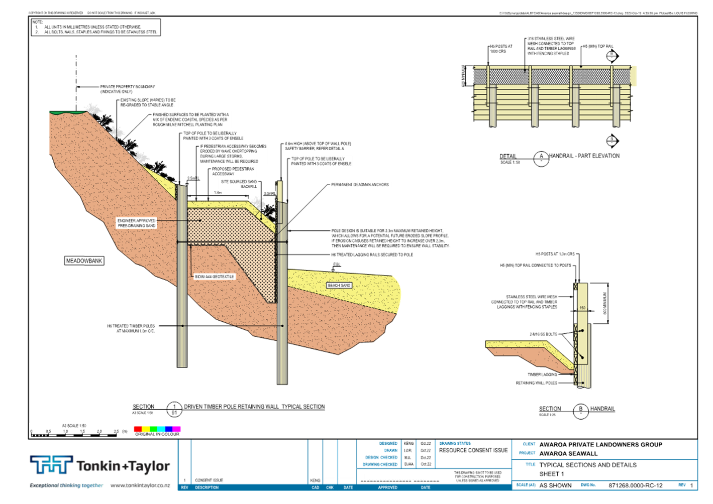
proposed structure is a 260m long vertical timber seawall with an exposed face
of up to a 2.3m maximum height. At the western end of the
seawall there will be beach level access to an elevated 1.8-metre-wide walkway
along the inside of the seawall. Public foot access will then be along the
esplanade until around 89 Awaroa Inlet, where a path will return to the beach.
The bank behind the seawall will be planted with coastal native plants
appropriate to the locality. The design and location of the proposed
wall structure has been designed to minimise adverse effects. Construction
costs for the proposed works will be met by the applicants who have also agreed
that they will enter into and be bound by a legal agreement with the Council
regarding their ongoing responsibility for maintenance and any liability
arising from the structure.
2.6 A
licence to occupy will be required for the structure on the reserve. The key
benefits of this application are that it will restore and protect public access
along the reserve and provide access to the sea.
2.7 The
application has been assessed under the Policy and no significant impediments
have been identified therefore approval is recommended.
3. Recommendation/s
/ Ngā Tūtohunga
That the Tasman District Council
1. receives
the Awaroa Seawall - Landowner Approval report, RCN25-09-5; and
2. gives consent as landowner for some 260 metres of
vertical timber pole seawall on Awaroa Local Purpose (Esplanade) Reserve as set
out in the application by the property owners at 89, 91, 97, 99, 105, 107, 109,
111, 113, 115, 117, 119, 121 and 123 Awaroa Inlet subject to:
a. a resource consent and, if required, a
building consent being granted prior to undertaking any further works on the
Reserve.
b. the owners of 89, 91, 97, 99, 105, 107,
109, 111, 113, 115, 117, 119, 121 and 123 Awaroa Inlet as direct beneficiaries
of the coastal erosion protection entering into a joint and several Licence to
Occupy for the seawall on the reserve; and
c. the owners of 89, 91, 97, 99, 105, 107,
109, 111, 113, 115, 117, 119, 121 and 123 Awaroa Inlet as direct beneficiaries
of the coastal erosion protection entering into an agreement with the Council
regarding the planting, ongoing maintenance, sand replenishment and any
liability, related to the seawall; and
d. the owners of 89, 91, 97, 99, 105, 107,
109, 111, 113, 115, 117, 119, 121 and 123 Awaroa Inlet obtaining the necessary
consents and approvals from the Department of Conservation for any sections of
the seawall that are located in the Abel Tasman Foreshore Scenic Reserve; and
3. notes that this approval is given by the Council as
landowner of the Reserve and is independent of the Council’s regulatory
role in assessing and deciding on any resource consent and building consent
applications related to the coastal erosion protection; and
4. notes that in accordance with the terms of this
resolution the Group Manager Community Infrastructure may exercise his
delegated authority (Delegations Register clause 5.9) to provide unconditional
written approval as an affected person under the Resource Management Act 1991
to the resource consent application.
4.1 The applicants are the owners of 14
properties from 89 - 123 Awaroa Inlet, Awaroa whose properties have a frontage
to the Reserve, also known as the Awaroa Private Landowners Group in attached
reports.
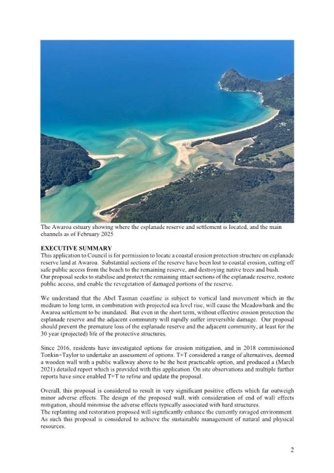
4.2 The Reserve has been under attack from
erosion since 2015/2-16 when the sandspit at the entrance to the estuary, which
protects the inner Awaroa Estuary from open sea wave effects, started to move
and recede. This left the area, known as Meadowbank, exposed and vulnerable to
erosion. In addition to the widening of the estuary entrance there have also
been changes in the flood tidal delta and channels system within the estuary.
4.3 At the western end of Meadowbank, almost
all the esplanade reserve has eroded, leaving an unstable near vertical bank.
Since the construction of a seawall in front of this bank, erosion has been
limited to wind and rain weakening the eroded vertical face, with some material
falling behind the wall. Further eastward, the Reserve is mostly unaffected due
to the protective effect of two other seawalls, the eastern most seawall has
generated some end effects causing some erosion in front of 89 and 91 Awaroa
Inlet.
4.4 Beach levels in front of all three walls
fluctuate regularly and in places where the western wall was incomplete,
seawater has scoured out the fill behind it further weakening the bank of the
Reserve. At the eastern end of the reserve there is a spit of sand which has
provided some protection to the reserve and in the centre the reserve is
protected by two contiguous seawalls.
4.5 In response to the erosion, beach
replenishment was undertaken by the Council in conjunction with residents in
2018. As identified above, there are also three timber seawalls along the
Reserve frontage. A seawall was constructed in front of the lodge at 107 Awaroa
Inlet approximately 20 years ago, (described as Wall 2 in attached reports),
this was consented. There is a section of unconsented seawall, constructed in
2021, in front of 97-105 Awaroa Inlet (Wall 3 in reports) and a further partly
consented seawall in front of 115 -123 Awaroa Inlet (Wall 1 in reports). Wall 1
was granted a conditional Council landowner consent in September 2021
(RCN21-09-5). Construction was started prior to a resource consent application
being considered, this resulted in an abatement notice being issued by the
Council. The Council agreed through a subsequent mediation process to accept a
resource consent application to formalise all the seawalls as part of an
integrated erosion control application.
4.6 Further assessment of the coastal
processes at play in the estuary and hydrodynamic wave modelling has been
undertaken by coastal experts. This is part of an effects assessment for the
seawalls to support both the landowner consent and the resource consent
applications.
4.7 The applicants are seeking approval from
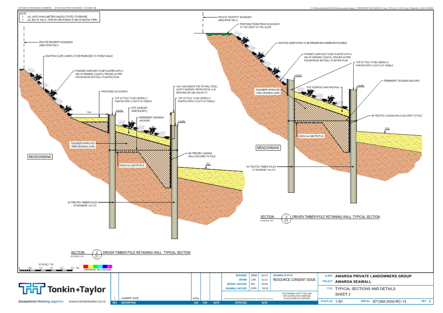
the Council as landowner of the Reserve for a amalgamation of Walls 1, 2 &
3 into one continuous structure, mostly located above Mean High Water Springs
(MHWS) on the seaward frontage of the Reserve. This includes moving a section
of Wall 1 slightly seaward to minimise excavation of the existing bank and
avoiding possible disturbance of a wāhi tapu site. Other changes will
include addition of a second row of timber poles with bracing between rows,
extension of the wall at its eastern end, installation of three lightweight
rebuildable steps to provide beach access along the wall replacing existing
structures and planting for stability and landscaping.
A walkway will be laid mid-height along part of the wall at the western end and
up to the top of the bank where the Reserve widens and the return to the beach
at the eastern end.
4.8 The seawalls will provide protection to
the Reserve and ultimately protect the Meadowbank properties that abut the
Reserve. The walkway along the Reserve will restore public access along the
reserve frontage and enable access to the private properties which abut the
reserve and have no other legal access. In addition, landscape values will be
enhanced through planting and the cultural elements protected
5. Analysis
and Advice / Tātaritanga me ngā tohutohu
5.1 The application follows the format set
out in Appendix 2 of the Policy and provides all the information needed for a
decision. The application is included as Attachment 1 – Application
for Landowner Consent, Awaroa, 27 August 2025, The application has been
analysed against the requirements of the Policy.
Reserve Land Description
5.2 The reserve that is the subject of this
application is the Awaroa Inlet Local Purpose (Esplanade) Reserve (the
Reserve) described as Lot 10 DP 8100, this land was vested in the Council in
1972 on subdivision of a larger title. A separate title has not been issued for
the Reserve; this is not uncommon for reserve land.
Assessment of Application
5.3 The Policy has a flow chart of the
landowner approval process, this assessment follows the flow chart that is
included in Figure 1 on the next page and considers the key questions at each
step in the process.
Figure 1:
Flowchart – Landowner approval process
Location of the coastal erosion control
structure
5.4 The proposed structure will largely be
located on the Reserve land above MHWS, some parts of the structure will be
below MHWS and above Mean Low Water Springs (MLWS) that is be located in the
Abel Tasman Foreshore Scenic Reserve (ATFS Reserve). This means that the
application will need to be considered by both administering bodies. The
Council is the administering body for the former and both the Council and
Department of Conservation (DoC) are jointly the administering body for the
later. DoC will consider a concession application for the parts of the
structure located in the ATFS Reserve. The seawall structure, including its
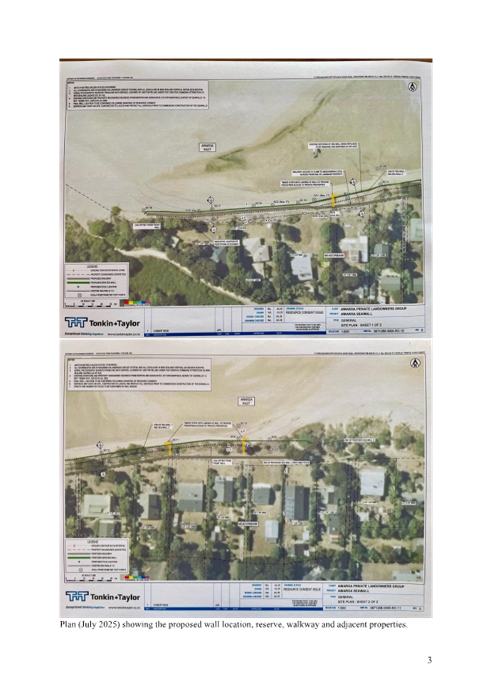
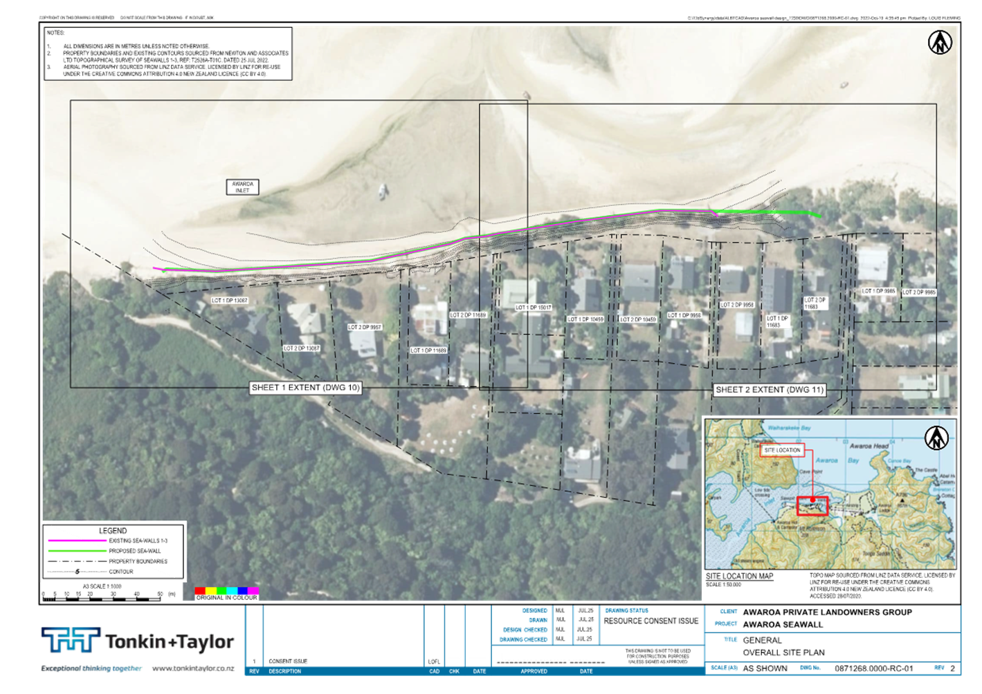
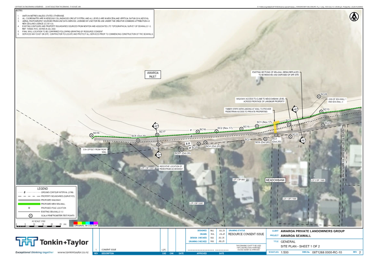
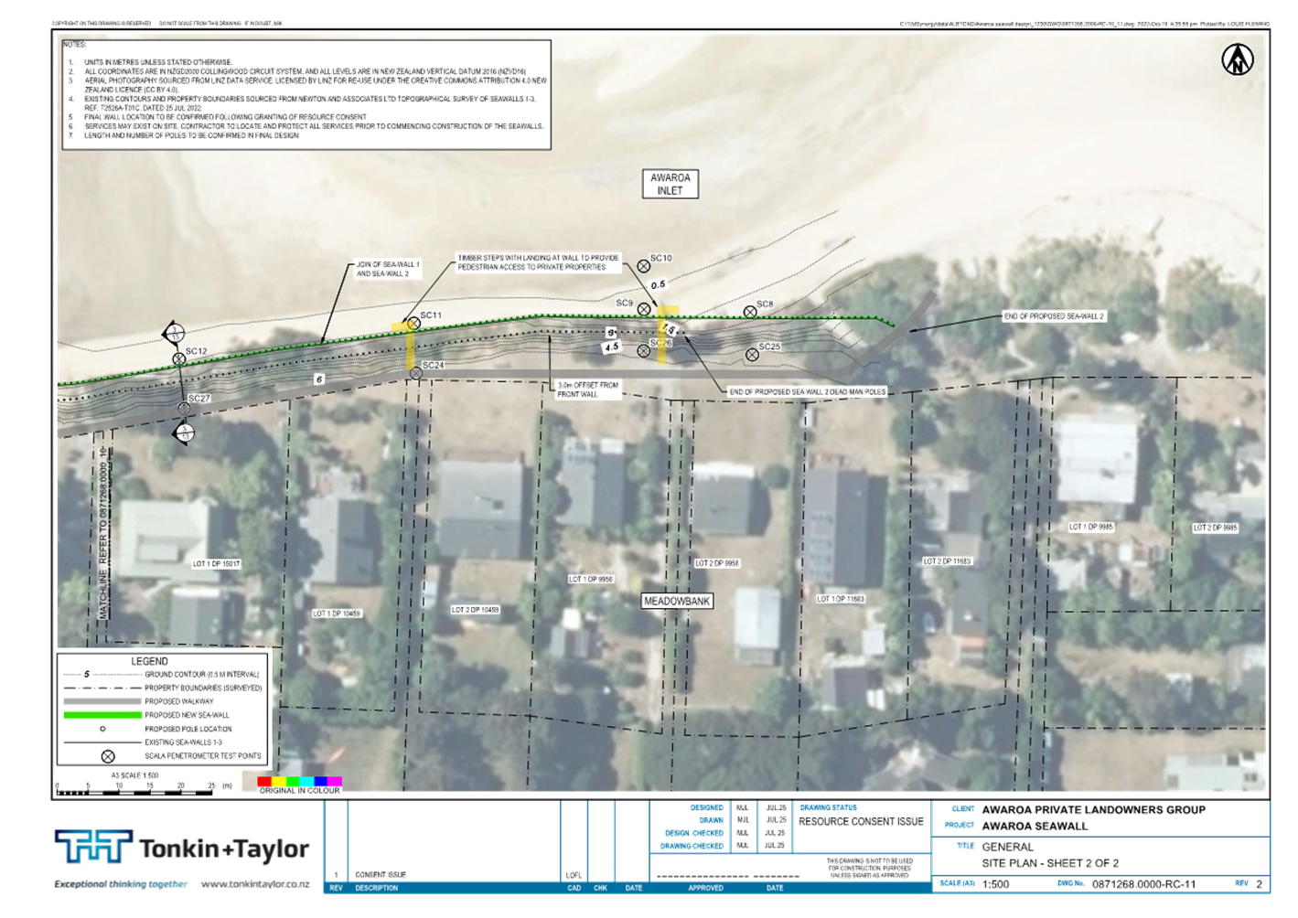
location, is shown in Attachment 2 - Awaroa Seawall, Tonkin + Taylor
– Jul 25 (5 sheets).
5.5 The Reserve is a Local Purpose
(Esplanade) Reserve. When assessing whether the proposed structure is
consistent with the purpose of an esplanade reserve, the Council needs to be
satisfied that:
a. the Reserve Land has conservation values AND the proposed
structure will contribute to the protection of those values by one of the means
set out, most likely by mitigating natural hazards to protect those values, or
b. the proposed structure enables public access to or along
the sea, or
c. the proposed structure enables public recreational use of
the reserve and adjacent sea, where compatible, with the conservation values of
the reserve.
Conservation Values
5.6 The application identifies that the bank
will be planted out with coastal native plants to enhance the natural values of
the reserve and enhance slope stability assisting to mitigate natural hazards.
The plants used will be species found growing naturally in the locality.
Planting will improve the visual effects as there is currently a mix of native
and exotic species, so the environment is highly modified.
Public Access
5.7 The structure will restore public access
along the reserve by establishing a walkway in part behind the wall structure
and in part along the top of the bank. Currently there is no public access
along the western end of the reserve as it has been eroded. The wall and
associated walkway will also improve access to the properties that abut the
Reserve. There are no formed roads at Awaroa so practical access to the
properties is from the beach to the Reserve via one of the access points and
then along the Reserve to the properties. It is proposed to construct three set
of lightweight stairs to the beach to replace a precarious existing stairway
that juts out onto the beach, and rehabilitate the area currently used for
access to the beach at the eastern end. This will provide good access to the
beach and the sea from the Reserve. Public recreation use by both Meadowbank
residents and visitors to the area will be significantly enhanced.
5.8 In summary, the seawall structure will
be consistent with the Reserve purpose in that it will restore and enhance
public access to and along the reserve. The natural values of the Reserve will
not be significantly compromised and in fact the proposed planting will assist
to stabilise and remedy the eroded slope, protect it from further erosion and
positively contribute to the native vegetation patterns in the area.
Reserve Management Plans
5.9 Is the proposed structure consistent
with the reserve management plan? Consideration needs to be given to the
Reserves General Policies 2015 and the relevant ward reserve management plan,
in this case the Golden Bay Ward Reserves Management Plan 2003.
5.10 The Reserves General Policies 2015 has several
policies relevant to this application. These are summarised on page 24 of
the Policy. These include demonstrating a need for the structure, particularly
a hard structure plus a list of considerations when evaluating a proposal for a
new structure such as, the design, effects, financial matters, and conditions
required. A number of these are considered in other parts of the Policy so are
covered in the relevant section rather than here. The coastal hazards policy
(5.3) requires that regard is given to policy 26 of the New Zealand Coastal
Policy Statement which gives an emphasis on using natural defences to protect
against coastal hazards.
5.11 The Golden Bay Ward Reserve Management Plan 2003
has several policies relevant to coastal erosion structures; these are outlined
on pages 27 and 28 of the Policy. The management plan allows the construction
of erosion control works, subject to Council approval. It identifies that
structures should not unnecessarily restrict foot access onto or across the
reserve. It prohibits structures unless they are compatible with the primary
purpose of the reserve and necessary to meet a demonstrated demand for public
use and permitted by the management policies for the reserve. Staff concur with
the applicant that the application is consistent with the plan.
Case for a Coastal Erosion Protection
Structure
5.12 In considering the case for a structure,
consideration is given to the need for a structure rather than soft engineering
solutions, whether alternatives have been considered and potential adverse
effects from what is proposed.
5.13 A report prepared by Tonkin & Taylor (T+T),
Coastal Erosion and Options Assessment for Awaroa Esplanade 2021 provided an
assessment of existing and future coastal erosion risk at the site. It assessed
several potential remedial options, including sand replenishment, their
effects, design life and cost. This report was originally prepared in 2018 and
updated in 2021 to reflect current conditions including further coastal erosion
and a timber pole sea wall design was added.
5.14 A further assessment, Awaroa Coastal Processes
Assessment was undertaken by T+T in 2024, this included an assessment of
coastal processes, hydrodynamic wave modelling, a seawall effects assessment
and feasibility assessment for sand replenishment.
5.15 The assessment outlines that the Awaroa Estuary is
a dynamic tidal system with morphological changes that occur over varying
timescales. Based on the coastal process assessment and hydrodynamic wave
modelling, an effects assessment was completed for the proposed seawall.
5.16 It concluded that overall, the fully integrated sea
wall proposal is expected to have beneficial effects on the public access along
the top of the wall and coastal erosion of the backshore, negligible effects on
the wider estuary morphology and water levels and a low effect on waves and
currents locally at the toe and sediment processes fronting the wall. The
potential effect on the adjacent shorelines is considered moderate as the
structure is being extending to tie into the adjacent wider beach areas
(therefore reducing the potential impacts of end effects). This effect should
be monitored and mitigated, if end effects are detected or reported. Mitigation
could include sand replenishment and/or wall extension and appropriate tie into
adjacent shoreline. With mitigations these moderate levels of effects could be
reduced to low.
5.17 These T&T reports have been prepared and
updated over a four-year period and each considers changes in the environment
since the previous report and modifies the conclusions slightly. The 2024
T&T report considers the entire Reserve frontage rather than having a focus
on the western end only. There has been significant investigation, modelling
and analysis of the Awaroa estuary including the entrance which shows that the
estuary is an extremely dynamic environment.
5.18 The Council in 2021 granted a landowner approval
for Wall 1 at the western end and through a subsequent mediation agreement it
was agreed to regularise the other walls. The 2024 T&T report confirms that
this revised integrated seawall proposal is an appropriate solution, and the
assessment of effects range from beneficial for public access to moderate
effects on adjacent shorelines, should end effects occur with the opportunity
to apply further mitigations to reduce this to low.
Design and Public Access
5.19 The consistency of the design of the structure with
the purpose of the Reserve particularly in relation to access, potential
adverse effects on other properties and any other coastal works in the area are
considered.
5.20 The proposed structure is a 260m long vertical
timber seawall with an exposed face of up to a 2.3m maximum height.
5.21 At the western end of the proposed structure there
will be beach level access to an elevated 1.8-metre-wide walkway along the
inside of the seawall. This walkway will lead to steps (or a ramp) that enables
easy access on foot to the upper level of the Reserve immediately before 121
Awaroa Inlet. Public foot access will then be along the esplanade in front of
adjacent properties, until around 89 Awaroa Inlet, where a path will return to
the beach.
5.22 The sloping bank behind the seawall will be graded
to a stable angle and planted with coastal native plants appropriate to the
locality.
5.23 The design and location of the proposed wall
structure has been designed to minimise adverse effects. It is likely however
that there will be an adverse effect on sand levels in front
of the seawall due to wave reflection and the confining of sediment behind the
structure that would otherwise have eroded from the bank and fed the beach. The
T&T coastal process assessment considered these effects to be very small
compared to the volume of sediment that is actively moving in the estuary but
noted that beach width in front of the wall could be expected to decrease
further over time.
5.24 The seawalls have now been in place along most of
the proposed seawall for four years, therefore the coastal engineers and the
applicants have had the opportunity to observe effects, make a realistic
assessment of their severity, and consider how best to manage and mitigate
these effects.
5.25 The revised design addresses end effects by
extending the seawall into significantly higher sand levels at each end. They
identify that this will require monitoring and will likely require localised
sand replenishment. They note that, at the eastern end, the seawall extends
into a historically stable and sizable raised sandbank that has been there for
the last twenty-five years. At the western end, sand levels have remained high
over the last four years but are now showing some signs of receding. The volumes
of sand required to keep the ends of the wall buried are quite small, in the
order of 10-15% of the sand moved in the 2018 sand push up.
5.26 In summary, the potential adverse effects have been
considered and solutions identified, all- tide public access will be restored
by providing a walkway.
Cost and Maintenance
5.27 Responsibility for the construction, maintenance
and any potential liability associated with the structure is considered.
5.28 Construction costs for the proposed works will be
met by the applicants, the property owners at 89 – 123 Awaroa Inlet with
property adjacent to the Reserve. Those property owners are aware that they
will be required to enter and be bound by a legal agreement with the Council
regarding their ongoing responsibility for maintenance and any liability
arising from the structure and have provide an assurance that they have the
financial capacity to fulfil their obligations.
5.29 The applicants have considered whether there are
any special circumstances the Council should take into account when considering
whether to contribute to the construction, maintenance or repair of the
structure. They have commented that “the subject of cost sharing
arrangements has not been deeply explored with council. As to who benefits, the
obvious beneficiaries are, in no particular order:
· The general public, from restoration of public access and amenity.
· The Council, as the administering body of the reserve, from having
remnants of their reserve saved, and from the restoration of the functions of
their reserve.
· The adjacent landowners, from having their properties more protected
from coastal erosion.
· The wider Awaroa community, from restoration of community access
along the frontage of the settlement, and from restoration of some of the
natural character of the reserve vegetation.
5.30 Rather than attempt to achieve an agreement on cost
sharing as part of this landowner consent process, (which could significantly
delay this application process), the applicants have suggested that any cost
contribution agreement should be considered separately.
5.31 The Council has incurred considerable costs to date
particularly in staff time working with the applicant and wider community on
this matter and for a sand push-up consent for Awaroa. The Reserves &
Facilities Department would be happy to provide appropriate plants for the bank
from Coastcare budgets. This would be the limit of what the Council would
expect to contribute.
Precedent and
wider Implications
5.32 The precedent of allowing a structure in this
location and what this would mean for other locations, is something the Council
needs to consider.
5.33 Tasman District has a long coastline and there are
pockets of coastal erosion at various points along that coastline. Each has
different factors that need to be considered, some are near river mouths, some
have a significant dune system in place, they all face different directions,
some having greater exposure to wind and currents than others. Therefore, each
situation needs to be fully investigated by coastal experts with an independent
peer review of the assessment, as has been done in this case, prior to
confirming an appropriate solution. The Policy provides a good framework to
achieve this.
5.34 An occupation agreement will be required for the
structure on the Reserve; it is appropriate that this be by way of a licence to
occupy. The key benefits of this application are that it will restore and
protect public access along the Reserve and provide access to the sea. As part
of the licence to occupy, the applicants will need to enter into an agreement
with the Council regarding the planting, ongoing maintenance, sand
replenishment, and any liability, related to the seawall.
Other Consents
5.35 Both building and resource consents will be
required. The applicant has engaged a resource consent planner to progress the
resource consent application. The building consent application will be lodged
following consideration of this application.
5.36 The applicant has advised that they will apply for
a DoC concession after the resource consent, this approach has been confirmed
by DoC as being appropriate.
6. Financial
or Budgetary Implications / Ngā Ritenga ā-Pūtea
6.1 The applicant is meeting the costs of
investigating solutions, consenting, constructing and maintaining the
structure. There are benefits to private landowners and the wider community
resulting from an approval. The Council has incurred some cost to date in
consenting a previous beach re-nourishment and is likely to contribute to
planting if this application is approved. These costs will be met from
Coastcare budgets. No further financial contribution has been budgeted.
7.1 The options are outlined in the
following table:
|
Option
|
Advantage
|
Disadvantage
|
|
1.
|
Give Landowner Approval (Recommended)
|
Restoration of the esplanade reserve and
reinstatement of pedestrian access along the Reserve.
|
Sand replenishment is likely to be
required in future, the effects of this are outside the reserve.
|
|
2.
|
Decline giving landowner approval
|
There are no obvious advantages in
declining this application.
|
All-tide public pedestrian access along
the reserve will be lost and the property owners adjacent to the Reserve will
have limited access to their properties
|
7.2 Option 1 is recommended.
8.1 The Reserves Act 1977 will require the
Council to grant an occupation agreement, in the form of a licence to occupy,
for the structure to be located on Reserve land that will include conditions
relating to planting, ongoing seawall and planting maintenance, beach
replenishment and managing any liability related to the seawall. This has been
covered in the report recommendations.
9. Iwi
Engagement / Whakawhitiwhiti ā-Hapori Māori
9.1 The applicant has advised that
consultation occurred prior to the 2021 application for landowner consent for
just the Wall 3 area. Further consultation and site visits preceded Iwi
providing a Cultural Impact Assessment in March 2023.
9.2 In mid-2024 agreement was reached with
the Council that the applicants would be party to a "four-way"
meeting involving DoC, Iwi, Council and the applicants. This proved complex to
achieve but eventually a Draft Position Statement was issued by Ngāti Rārua, Ngāti Tama, Te Ātiawa and the Department of Conservation that explained their views and
concerns about the proposal for Awaroa Walls 1-3.
9.3 In summary, concerns were expressed
about:
· The potential for end of wall effects arising from the structure
· The potential for negative effects on the geomorphology and natural
processes of the estuary
· The potential for disturbance of culturally significant artifacts
and wāhi tapu
· Uncertainty about where responsibility lay for the maintenance and
upkeep of the proposed structure and its eventual removal
· Suggested that the applicants should work collaboratively with DoC
and Iwi to develop a more culturally sensitive response.
9.4 The applicants responded to these
concerns and endeavoured to explain what steps could be taken to minimise and
avoid the potential effects that DoC and Iwi identified. The applicants also
stated they were keen and willing to work collaboratively as suggested.
9.5 The T+T coastal processes assessment,
final version dated 19 December 2024 analysed many of the potential concerns
referred to in the Draft Position Statement and was a key part of the
applicant's response. Unfortunately, because of the timing of this report, it
was not available when DoC and Iwi prepared their Draft Position Statement.
9.6 With regard to wāhi tapu, the
applicants engaged an archaeologist in August 2022, to advise on an
archaeological authority, accidental discovery protocols, and Iwi monitoring.
The archaeologist raised an archaeological record N26/319. Changes have since
been made to the design and positioning of the proposed wall to minimise and
avoid the potential disturbance that Iwi highlighted.
9.7 The applicant has advised that
communication with Iwi since mid-June 2025 has established that Iwi do not wish
to meet, (to develop a collaborative response) but prefer that the applicants
go ahead and lodge the Resource Consent application and they will put their
views forward as part of the consenting process. The applicants remain open to
collaborating with Iwi to improve their proposal so that the significant values
in this area can be maintained, enhanced and protected.
10. Significance
and Engagement / Hiranga me te Whakawhitiwhiti ā-Hapori Whānui
10.1 As outlined in the following table, we
consider this activity overall to be of medium significance to residents with
coastal properties where there is a risk of coastal erosion.
|
|
Issue
|
Level of
Significance
|
Explanation of
Assessment
|
|
1.
|
Is there a high level
of public interest, or is decision likely to be controversial?
|
Medium
|
Coastal erosion is an
issue for a number of coastal communities. The Council has an obligation to
give preference to natural defences. Community preferences tend to favour
hard engineered solutions.
|
|
2.
|
Are there impacts on
the social, economic, environmental or cultural aspects of well-being of the
community in the present or future?
|
Low
|
There is a social
benefit to reinstating public access across the reserve and protecting the
reserve from erosion. There is an offset to environmental impacts through
planting to stabilise the slope.
|
|
3.
|
Is there a
significant impact arising from duration of the effects from the decision?
|
Medium
|
The structure has an
estimated life of around 30 years. There are no significant impacts related
to the duration identified.
|
|
4.
|
Does the decision
relate to a strategic asset? (refer Significance and Engagement Policy for
list of strategic assets)
|
Low
|
Reserves and
Cemeteries in their entirety are a strategic asset, this policy will
potentially have an impact on a single coastal reserve where it is impacted
by erosion and adjoined by private properties.
|
|
5.
|
Does the decision
create a substantial change in the level of service provided by Council?
|
N/a
|
|
|
6.
|
Does the proposal,
activity or decision substantially affect debt, rates or Council finances in
any one year or more of the LTP?
|
Low
|
No commitments are
proposed other than consideration of Council input to funding, no budget has
been identified to enable other than a minor contribution with planting.
|
|
7.
|
Does the decision
involve the sale of a substantial proportion or controlling interest in a CCO
or CCTO?
|
N/a
|
|
|
8.
|
Does the
proposal or decision involve entry into a private sector partnership or
contract to carry out the deliver on any Council group of activities?
|
N/a
|
|
|
9.
|
Does the proposal or
decision involve Council exiting from or entering into a group of
activities?
|
N/a
|
|
|
10.
|
Does the proposal
require particular consideration of the obligations of Te Mana O Te Wai
(TMOTW) relating to freshwater or particular consideration of current
legislation relating to water supply, wastewater and stormwater
infrastructure and services?
|
N/a
|
|
11. Communication
/ Whakawhitiwhiti Kōrero
11.1 The landowner approval process is the first of a
number of approvals required including resource and building consents. There is
also a need for DoC to grant a concession. Any public communication should be
following completion of these processes.
12.1 The key risks are identified and analysed below:
|
Risk
|
Likelihood
(H/M/L)
|
Impact
(H/M/L)
|
Comments & Risk
Management Strategies (Mitigations)
|
|
Further site works prior to other consents being obtained
|
L
|
M
|
This risk was realized following the 2021 landowner
approval and is unlikely to be repeated.
|
|
Conditions of approval not met
|
L
|
M
|
Enforcement action may be required to ensure compliance.
|
13. Climate
Change Considerations / Whakaaro
Whakaaweawe Āhuarangi
13.1 The proposal would
contribute to the goal for tree planting and land stability and to some degree
detract from goals relating to adaptation in the coastal environment.
14. Alignment
with Policy and Strategic Plans / Te Hangai ki ngā aupapa Here me ngā
Mahere Rautaki Tūraru
14.1 A policy for coastal erosion protection structures
on Council Reserve land has been prepared to assist private landowners in
outlining the information required when making an application for landowner
consent and to assist the Council in its role as decision maker by detailing
matters the Council will consider.
14.2 The application has been assessed
against the policy and complies with the policy, therefore approval is
recommended.
15. Conclusion / Kupu Whakatepe
15.1 The application seeks landowner consent for
construction of a seawall to protect the esplanade reserve, reinstate public
access across the reserve and protect private properties from coastal erosion.
The solution has been arrived at following an assessment by coastal
specialists.
15.2 The applicants are proposing to fund the
construction and maintenance of the structure and enter into an agreement to
cover any liability arising from the seawall.
15.3 The application has been assessed under Tasman
District Council Coastal erosion protection structures on Council Reserve Land
Policy – June 2024 and no significant impediments have
been identified therefore approval is recommended.
16. Next
Steps and Timeline / Ngā Mahi Whai Ake
16.1 The next steps will be for the applicants to
progress the resource and building consent applications.
16.2 A licence to occupy plus an agreement for the ongoing maintenance,
and any liability, related to the seawall agreement would need to be prepared
and entered into with the applicant prior to construction of the structure.
|
1.⇩
|
2025-08
Awaroa Landowner Consent Application
|
22
|
|
2.⇩
|
2025-07 T
& T Awaroa Walls Design Drawings
|
39
|
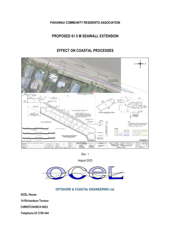
7.2 Pakawau Seawall - Landowner Approval
Decision Required
|
Report
To:
|
Tasman
District Council
|
|
Meeting
Date:
|
11
September 2025
|
|
Report
Author:
|
Grant
Reburn, Reserves and Facilities Manager
|
|
Report
Authorisers:
|
Richard
Kirby, Group Manager - Community Infrastructure
|
|
Report
Number:
|
RCN25-09-6
|
1. Purpose
of the Report / Te Take mō te Pūrongo
1.1 The
purpose of this report is for the Council, as landowner of the Pākawau
Local Purpose - Esplanade Reserve (Reserve), to consider giving consent for a
coastal erosion protection structure (seawall) on part of the Reserve.
1.2 This
report assesses an application from the Pākawau Community Residents
Association (Association) on behalf of the owners of 1132, 1134 and 1136
Collingwood-Pūponga Main Road against the criteria set out in the Tasman
District Council Coastal Erosion Protection Structures on Council Reserve Land
Policy – June 2024 (Policy).
1.3 The
landowner consent process under the Reserves Act considers whether coastal
erosion protection should be constructed on the reserve. The process considers
the purpose of the reserve and the reserves policy preference to use
sustainable natural solutions to minimise the impact on the natural environment
and promote natural resilience. The resource consent process is a separate
regulatory process as determined by the Resource Management Act.
1.4 In
giving approval as landowner, the Council is not giving any commitment
regarding its independent role in assessing and deciding on any resource
consent and/or building consent application related to this coastal erosion
protection.
2. Summary
/ Te Tuhinga Whakarāpoto
2.1 The
application follows the criteria and application process in the Policy.
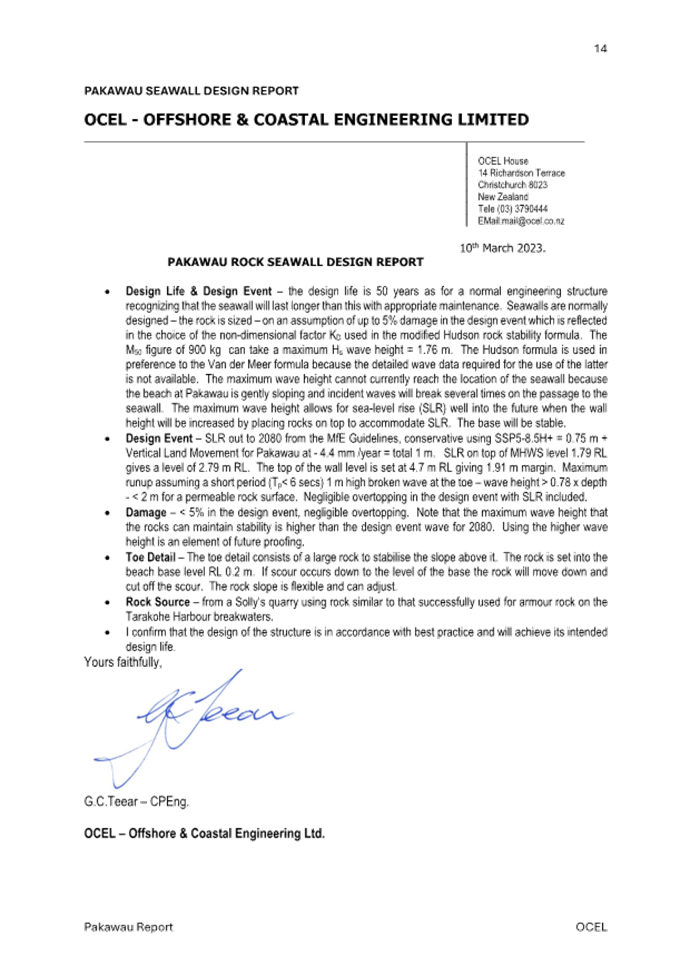
2.2 Several
reports prepared by OCEL Consultants provide an assessment of coastal erosion
at the site, they assess various remedial options and their effects and
conclude that an engineered rock revetment is the preferred option as it has
the least effects on the environment of the hard engineering rock seawall
types.
2.3 Construction
costs for the proposed works will be met by the applicants who have also agreed
that they will enter into, and be bound, by a legal agreement with the Council
regarding their ongoing responsibility for maintenance and any liability
arising from the erosion protection.
2.4 A
licence to occupy will be required for the structure on the reserve. The key
benefits of this application are that it will restore and protect public access
along the reserve and provide access to the sea.
2.5 The
application has been assessed under the Policy, and no significant impediments
have been identified therefore Council landowner approval is recommended
subject to a resource consent for the works being granted.
3. Recommendation/s
/ Ngā Tūtohunga
That the Tasman
District Council
1. receives
the Pakawau Seawall - Landowner Approval RCN25-09-6; and
2. gives landowner approval for the construction of
coastal erosion protection at the southern end of Pākawau Local Purpose -
Esplanade Reserve in the front of 1132, 1134 and 1136 Collingwood-Pūponga
Main Road, subject to;
a. a resource
consent and, if required, a building consent being granted prior to any works
commencing; and
b. the owners of 1132,
1134 and 1136 Collingwood-Pūponga Main Road as direct beneficiaries of the
coastal erosion protection entering into a joint and several Licence to Occupy
for any erosion protection placed on the reserve; and
c. the owners of
1132, 1134 and 1136 Collingwood-Pūponga Main Road as direct beneficiaries
of the coastal erosion protection entering a joint and several agreement with
the Council regarding the ongoing maintenance and any liability, related to the
erosion protection; and
3. notes that this approval is given by the Council as
landowner of the reserve and is independent of Council’s regulatory role
in assessing and deciding on any resource consent and building consent
applications related to the coastal erosion protection; and
4. notes that in accordance with the terms of this
resolution the Group Manager Community Infrastructure may exercise his
delegated authority (Delegations Register clause 5.9) to provide unconditional
written approval as an affected person under the Resource Management Act 1991
to the resource consent application.
4.1 The
applicant is the Association on behalf of three landowners at 1132-1136
Collingwood-Pūponga Main Road who have properties abutting the Reserve.
The Association is seeking approval to construct 61.5 metres of rock revetment
on the Reserve along the frontage of three residential properties (1132-1136)
effectively extending a length of existing rock revetment (384 metres) that
lies to the south. The rock revetment is intended to provide protection from
coastal erosion to the properties, provide walking access along part of the
Reserve, include steps to access the beach and will be softened visually with
indigenous vegetation. This application follows the implementation of a similar
revetment on the Reserve in front of the 3 properties immediately to the south
of this one in 2022.
4.2 The application for a revetment
was initially lodged in June 2024 but was put on hold until all the required
information had been received. This information was provided in August 2025.
5. Analysis
and Advice / Tātaritanga me ngā tohutohu
5.1 The
Association’s application follows the format set out in the Policy and
with the addition of the supplementary information provided in August 2025 now
provides the information needed for a decision. The application is included as Attachment
1.
Reserve Land
Description
5.2 The
Reserve, which is the subject of the application, is Pākawau Local Purpose
– Esplanade Reserve described as Lot 20 DP 5716; this land was vested in
the Council in 1959 on subdivision of a larger title. A separate title has not
been issued for the reserve; this is not uncommon for reserve land.
Assessment of Application
5.3 The
Policy has a flow chart of the landowner approval process; this assessment
follows the flow chart that is included in Figure 1 and considers the key
questions at each step in the process.
Figure 1:
Flowchart – Landowner approval process

Location of
the coastal erosion control structure
5.4 The
applicant states that the proposed structure is to be located on the Reserve
land above Mean High Water Springs (MHWS). This has been included in a drawing
prepared by OCEL Consultants in 2025 and included as Attachment 2.
5.5 The
drawing in Attachment 2 also shows the location and typical
cross-section of the proposed structure which is like the previous structures
to the south.
Consistency with Reserve Purpose
5.6 The
drawing in Attachment 2 also shows the location and typical
cross-section of the proposed structure which is similar to the previous
structures to the south.
5.7 The
Reserve is a Local Purpose (Esplanade) Reserve. When assessing whether the
proposed structure is consistent with the purpose of an esplanade reserve, the
Council needs to be satisfied that:
a. the reserve land has conservation values AND the
proposed structure will contribute to the protection of those values by one of
the means set out, most likely by mitigating natural hazards to protect those
values, or
b. the proposed structure enables public access to or
along the sea, or
c. the proposed structure enables public recreational
use of the reserve and adjacent sea, where compatible, with the conservation
values of the reserve.
Conservation Values
5.8 The
Reserve extends around 800m in a north-south direction in front of properties
from 1118 – 1194 Collingwood–Pūponga Main Road. A
continuation of the rock revetment to the north is proposed in front of a
further three properties.
5.9 A
coast care programme is in place from about mid-way along the frontage and
extends to the Tomatea Point Recreation Reserve. There is a risk that end
effects from the proposed revetment could have an adverse effect on the reserve
to the north of the wall, the applicant has considered this and have included a
specially designed end wall that they say will keep end effects to a minimum.
5.10 There
appears to have been some erosion created from ends effects from the previous
stage of the revetment which had a similar end wall, there is some concern that
as the revetment moves northward it is moving closer to a successful Coast Care
programme putting that work at risk.
5.11 The
coastal engineers, advising the applicant, OCEL, consider the end effects on
the current revetment to be insignificant and therefore are of the view that
the overall adverse effects on the coastal environment of the proposed
extension are no more than minor.
5.12 The
application provides for a planted strip along the top of the wall planted with
coastal native plants to enhance the natural values of the reserve and down the
face of the revetment helping to reduce the visual impact. The nominated plants
are appropriate to this location. Planting into the gaps between the rock is
not intended as the vegetation would be destroyed during storm events.
Vegetation cascading down the wall will be more durable and mitigate replanting
after storm events.
5.13 This
approach is supported by staff however the planting that was required as part
of the previous stage has not yet been done despite compliance notices being
issued.
5.14 The
applicant could be bonded to cover end effects and the planting work to address
this matter. The applicant’s Coastal Engineer states in their report
that, “there is no justification for a bond to cover end effects, they
are of no significance at Pākawau”.
Public Access and Recreational Use
5.15 A
1.5m wide gravel path will be provided along the top of the wall to restore
public access along the reserve. There is currently no public access across
this part of the reserve. This would provide public access along this section
of the reserve and to the beach via some steps. The provision of a path and
steps to the beach is supported.
5.16 As
identified in the section on public access, the applicant proposes to build a
set of steps into the revetment. These would utilise selected rock for the
steps and include a simple rope and pole handrail that meets recreational use
standards. This would restore public access to the beach and the sea.
5.17 In
summary, the structure will be consistent with the Reserve purpose in that it
will restore and enhance public access to and along the reserve. The natural
values of the Reserve will not be significantly compromised as there are no
significant trees or other vegetation in this area of the Reserve, the
vegetation that was there has been undermined by erosion and removed. There is
some risk that this approach is just moving the issue further along the
reserve.
Reserve Management Plans
5.18 The
policy requires consideration of whether the proposed structure is consistent
with the reserve management plan. In this section consideration needs to be
given to the Reserves General Policies 2015 and the relevant ward reserve
management plan, in this case the Golden Bay Ward Reserves Management Plan
2003.
5.19 The
Reserves General Policies 2015 has several policies relevant to this
application, these include demonstrating a need for the structure, particularly
a hard structure plus a list of considerations when evaluating a proposal for a
new structure such as, the design, effects, financial matters, and conditions
required. A number of these are considered in other parts of the Policy so are
covered in the relevant section of this report rather than here. The coastal
hazards policy (5.3) requires that regard be given to policy 26 of the New
Zealand Coastal Policy Statement (NZCPS) which gives an emphasis on using
natural defences to protect against coastal hazards.
5.20 The
applicant has acknowledged the requirement to encourage and promote
“natural defences” as set out in policies 25 and 26 of the NZCPS
but states that these may not always be appropriate and that policy 27 provides
that hard protection in certain locations is the only sustainable method of
coastal protection. This section has been quoted out of context, policy 27 in
the NZCPS, states this only relates to the protection of existing
infrastructure of national or regional significance. Policy 27 (4) says that
“Hard protection structures, where considered necessary to protect
private assets, should not be located on public land if there is no significant
public or environmental benefit in doing so”. The applicant argues that
it considers that there are significant public and private benefits of locating
the structure on reserve as follows:
· It is a matter of
National Importance under Part 2 (Section 6) of the RMA to provide public
access to and along the coast. This public access will be protected and
enhanced by this proposal and would otherwise be lost with the “do
nothing” approach.
· There is a
significant public benefit is providing a safe stable rock revetment structure
that would provide safe and sustainable access to the coast in comparison to
the present unstable and unsafe an effectively unusable access to the beach.
· Under Section 2 of
the RMA and the definition of “environment” “people and
communities” are included as part of “ecosystems and their
constituent parts”. In this case the people and community of this part of
Pākawau will significant “environmental benefit” from the
proposal structure.
· There is
significant public benefit from landowners funding rock protection to protect a
public esplanade reserve, at no cost to the general rate payer, and maintaining
the structure in perpetuity.
· Housing is
considered a “physical resource” which is included as part of the
definition of “environment” under the RMA. The proposed structure
will enable the long-term sustainability of the three houses in question which
is a significant environment benefit in comparison to the potential long-term
loss of the houses and the reserve itself without the hard protection.
5.21 The
Golden Bay Ward Reserve Management Plan 2003 has several policies relevant to
coastal erosion structures; these are outlined on pages 27 and 28 of the
Policy. The management plan allows the construction of erosion control works,
subject to Council approval. It identifies that structures should not
unnecessarily restrict foot access onto or across the reserve. It prohibits
structures unless they are compatible with the primary purpose of the reserve
and necessary to meet a demonstrated demand for public use and permitted by the
management policies for the reserve. The Policies in the plan related to Rural
Recreation and Esplanade Reserves (policy 6.4.6) allows the construction of
erosion control works subject to Council approval. The section on the
Pākawau Esplanade Reserve in its description of the Reserve acknowledges
the presence of rock barriers on the reserve and states that the protection of
the reserve from coastal erosion is an important issue. It does not provide any
further direction on how this issue will be managed. Staff concur with the
applicant that the application is consistent with the plan.
Case for a coastal erosion protection
structure
5.22 In
considering the case for a structure, consideration is given to the need for a
structure rather than soft engineering solutions, whether alternatives have
been considered and potential adverse effects from what is proposed.
5.23 Three
reports have been prepared by OCEL Consultants, the first in September 2015 the
second in September 2021 and a third in August 2025 (Attachment 3).
These have canvassed the options and for coastal protection. The reports
conclude that an engineered rock revetment is the preferred option as it has
the least effects on the environment of the hard engineering rock seawall
types. They note that hard rock revetment design is now highly developed and
proven to work in this environment. Careful placement of the right size hard
rock as per the recommended design will provide long lasting sustainable
protection in this location and this has been shown with other similar rock
revetment nearby such as Totara Avenue and the properties to the south of the
site, that have shown that that rock revetments are successful and sustainable
option for these coastal environments.
5.24 OCEL’s
August 2025 report advises that the erosion at Pākawau is caused by the
episodic East /Southeast storm events that generate significant wind
waves that erode sand from the beach and carry it north by littoral drift.
Outside of the storm events, the beach at Pākawau is very calm and is a
“low wave energy” beach which means it has very limited opportunity
for the beach to recover after storm events. While the Council has attempted
“soft” option solutions of sand push ups and coastal care
plantings, these are quickly washed away in subsequent storm events are not a
long term nor effective protection.
Design and Public Access
5.25 The
consistency of the revetment design with the purpose of the Reserve
particularly in relation to access, potential adverse effects on other
properties and any other coastal works in the area are considered.
5.26 The
extent of the proposed works is from 1132-1136 Collingwood-Pūponga Main
Road. The coastal protection works will consist of a 61.5m engineered rock
seawall. OCEL Consultants believe that a hard engineering option is the only
construction type which will offer long duration protection. An engineered rock
revetment seawall is the preferred option as it has the least effects on the
environment of the hard engineering seawall types. The irregular surface of the
rock matrix serves to dissipate wave energy, reducing wave runup and
reflection. This reduces the potential for overtopping allowing the height of
the wall to be minimised.
5.27 The
wall will be of similar design and construction to the existing seawall to the
south of the site and will join into this seawall to form a continuation. The
seawall will be constructed within the approximately 20m wide esplanade
reserve. The top of the seawall will be variable from RL5.16m - 5.6m to match
the approximate top of the existing ground level, with the back of the seawall
placed a minimum of 2.0m seaward of the esplanade reserve/private property
boundary. This will allow for the seawall to be built up an additional 1.0m
higher should this be required due to future sea level rise over and above the
minimum 0.5m sea level rise that the wall has been designed for, this extension
would sacrifice the 1.5m wide public access track between the private property
boundaries and the back of the seawall.
5.28 The
toe of the seawall is buried below the beach to a depth of 2.0m MSL. This
section of the revetment has been constructed as a vertical down stand to
minimise the width of the seawall. The northern end will have a 30 degree
return of the seawall inshore to tie the revetment back into the existing upper
beach. This return ensures the wall batter continues into the zone where end
effects (scouring caused by wave reflections off a vertical or steep face)
would occur. From observations of the existing rock revetment seawalls adjacent
to the site, which are steeper and have no return inshore, there has been minor
impact from end effects. The placement of the return inshore will further
minimise any potential of end effects. Drawing DR-150806-007 Rev.3 (Attachment
2) shows the extent and construction of the proposed seawall.
5.29 The
applicant also proposes to construct a set of steps into the revetment; this
would utilise selected rock for the steps and include a simple rope and pole
handrail that meets recreational use standards.
Cost and Maintenance
5.30 Responsibility
for the construction, maintenance and any potential liability associated with
the structure is considered.
5.31 Construction
and maintenance costs for the proposed works will be met by the property owners
of 1132, 1134 and 1136 Collingwood-Pūponga Main Road. They will be fully
responsible for the maintenance and repair of the structure. Those property
owners have agreed that they will enter and be bound by a legal agreement with
the Council regarding their ongoing responsibility for maintenance and any
liability arising from the structure.
5.32 The
applicants have considered whether there are any special circumstances the
Council should consider when determining whether to contribute to the
construction, maintenance or repair of the structure.
5.33 The
applicant considers there are significant benefits to the Council for this
proposal in that the local community is largely funding the construction and
ongoing maintenance of the structure and that it will ensure the sustainability
of the reserve itself and the public access it provides and the sustainability
of a group of houses that are in grave danger of being lost to the sea by
coastal erosion.
5.34 They
also state that the proposal will not interfere with the ongoing “coast
care” coastal protection scheme that is being carried out further north
of the beach towards Tomatea Point where the coastal hazard is much less, and
the coast is even advancing.
Other Consents
5.35 A resource consent is required and has been
applied for contemporaneously with this application. A building consent
application will be lodged once landowner approval and a resource consent are
granted, however it may not be required.
6. Financial
or Budgetary Implications / Ngā Ritenga ā-Pūtea
6.1 The applicant is meeting the cost
of design, consenting, constructing and maintaining the revetment. There are
benefits to private landowners and the wider community resulting from an
approval. The Council has incurred some costs previously in consenting and
providing sand push-ups and further north on the reserve supporting a Coastcare
programme. These costs have been met from Coastcare budgets. No further
financial contribution has been budgeted.
7.1 As
landowner of the Pākawau Local Purpose - Esplanade Reserve, the Council
has two options as outlined in the following table:
|
Option
|
Advantage
|
Disadvantage
|
|
1.
|
Give landowner consent for coastal
erosion protection on Pākawau Local Purpose – Esplanade Reserve.
|
Restoration of the esplanade reserve and
reinstatement of pedestrian access along the Reserve.
|
A coastal erosion protection structure
may adversely affect the natural environment if not assessed, constructed and
managed well.
|
|
2.
|
Decline landowner consent for coastal
erosion protection to be constructed on Pākawau Local Purpose –
Esplanade Reserve.
|
Declining landowner consent would result
in the retention of the current natural environment.
|
Over time the esplanade reserve is likely
to be permanently lost together with all-tide pedestrian access along the
Reserve.
|
7.2 Option 1 is
recommended
8.1 The Reserves Act 1977 will
require the Council to grant a licence to occupy for the structure to be
located on Reserve land. It will include conditions relating to planting,
ongoing seawall and planting maintenance and managing any liability related to
the seawall. This has been covered in the report recommendations.
9. Iwi
Engagement / Whakawhitiwhiti ā-Hapori Māori
9.1 The applicants have advised that
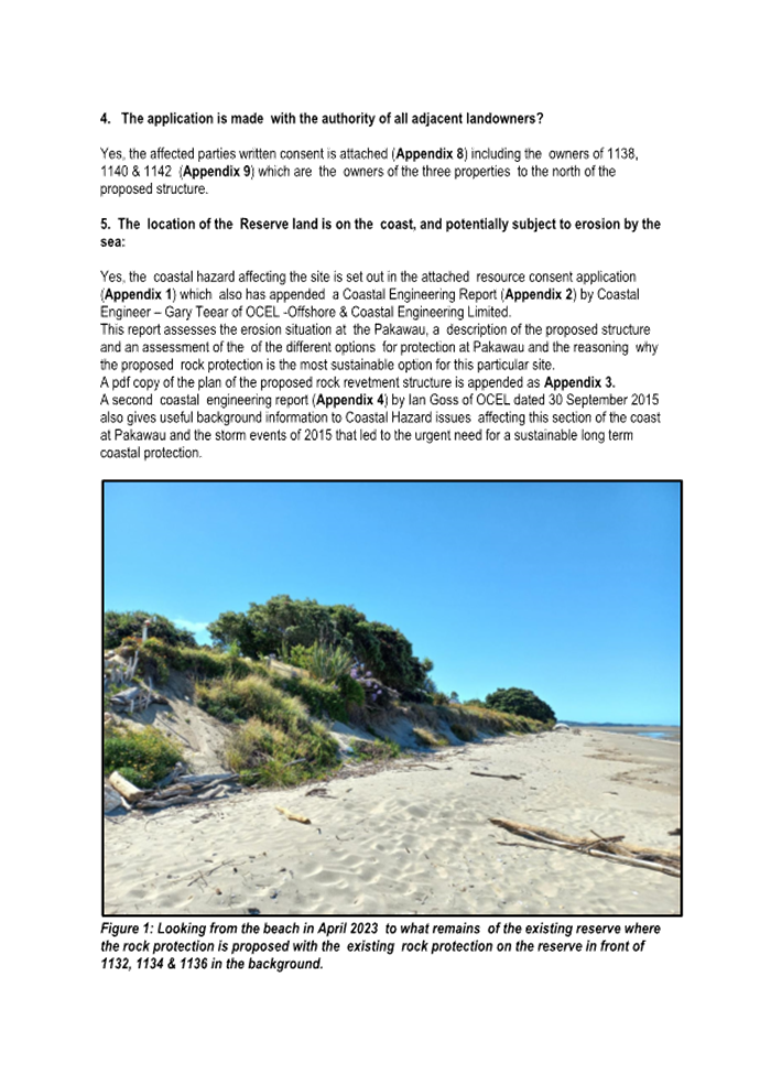
Manawhenua ki Mohua are fully supportive of this application and recognise the
importance of the Pākawau community. In a letter dated
7 April 2025 (Attachment 4) Manawhenua Ki Mohua have advised that it
supports the protection and preservation of the coastal whenua/ foreshore at
Pākawau as it holds deep significance to the Iwi of Ngati Tama, Te
Ātiawa and Ngati Rārua having been kainga/ Pā sites in the past.
An iwi monitor will undertake monitoring during the construction of the
revetment.
10. Significance
and Engagement / Hiranga me te Whakawhitiwhiti ā-Hapori Whānui
10.1 As
outlined in the following table, we consider this activity overall to be of
high significance to residents with coastal properties where there is a risk of
coastal erosion, and of medium significance to some iwi/Māori.
|
|
Issue
|
Level of
Significance
|
Explanation of
Assessment
|
|
1.
|
Is there a high level
of public interest, or is decision likely to be controversial?
|
Medium
|
This decision is only
about landowner consent and not about consenting of any coastal erosion
protection proposal. There may be some misinterpretation that this decision
is approving the coastal erosion protection when it is not.
|
|
2.
|
Are there impacts on
the social, economic, environmental or cultural aspects of well-being of the
community in the present or future?
|
Very Low
|
This landowner
decision has very low, if any, impact on the social, economic, environment or
cultural aspects of well-being of the community.
|
|
3.
|
Is there a
significant impact arising from duration of the effects from the decision?
|
Low
|
There is some social
benefit to reinstating public access across the reserve and protecting the
reserve from erosion. All Pākawau is within a Cultural Heritage
Precinct. Manawhenua ki Mohua has been consulted, they have requested
revetment construction is monitored, the applicant has agreed to this.
|
|
4.
|
Does the decision
relate to a strategic asset? (refer Significance and Engagement Policy for
list of strategic assets)
|
Low
|
Reserves and
Cemeteries in their entirety are a strategic asset, this policy will
potentially have an impact on a single coastal reserve where it is impacted
by erosion, and this is threatening private properties.
|
|
5.
|
Does the decision
create a substantial change in the level of service provided by Council?
|
None
|
This does not change
the level of service provided by the Council.
|
|
6.
|
Does the proposal,
activity or decision substantially affect debt, rates or Council finances in
any one year or more of the LTP?
|
Low
|
No financial
contribution is proposed. The construction of the revetment and associated
landscape works are being funded by the Association.
|
|
7.
|
Does the decision
involve the sale of a substantial proportion or controlling interest in a CCO
or CCTO?
|
No
|
This decision does
not involve any sale or part thereof of a CCO or CCTO.
|
|
8.
|
Does the
proposal or decision involve entry into a private sector partnership or
contract to carry out the deliver on any Council group of activities?
|
No
|
This decision does
not involve any entry into private sector partnership.
|
|
9.
|
Does the proposal or
decision involve Council exiting from or entering into a group of
activities?
|
No
|
This decision does
not involve the Council exiting from or entering into a group of activities.
|
|
10.
|
Does the proposal
require particular consideration of the obligations of Te Mana O Te Wai
(TMOTW) relating to freshwater or particular consideration of current
legislation relating to water supply, wastewater and stormwater
infrastructure and services?
|
N/a
|
|
11. Communication
/ Whakawhitiwhiti Kōrero
11.1 The landowner approval process is the first
of several approvals required including resource and building consents, any
communication should follow completion of these processes.
12.1 The
key risks are identified and analysed below:
|
Risk
|
Likelihood
(H/M/L)
|
Impact
(H/M/L)
|
Comments
& Risk Management Strategies (Mitigations)
|
|
Site works occur prior to other
consents being obtained
|
L
|
L
|
The
project is being managed by the Community Association, they have undertaken
several projects previously so understand the process well.
|
|
Conditions of approval not met
|
L
|
M
|
Enforcement
action may be required to ensure compliance.
|
13. Climate
Change Considerations / Whakaaro
Whakaaweawe Āhuarangi
13.1 The proposal would contribute to the goal
for planting and land stability and to some degree detract from goals relating
to adaption in the coastal environment.
14. Alignment
with Policy and Strategic Plans / Te Hangai ki ngā aupapa Here me ngā
Mahere Rautaki Tūraru
14.1 A
policy for coastal erosion protection structures on Council Reserve land has
been prepared to assist private landowners in outlining the information
required when making an application for landowner consent and to assist the
Council in its role as decision maker by detailing matters the Council will
consider.
14.2 The application has been assessed against
the policy and complies with the policy.
15. Conclusion
/ Kupu Whakatepe
15.1 The
application seeks landowner consent for construction of a rock revetment to
protect the esplanade reserve, reinstate public access across the reserve and
protect private properties from coastal erosion. The solution has been arrived
at following an assessment by coastal specialists and is similar in scale and
design to work consented in 2022.
15.2 The
applicants are proposing to fund the construction and maintenance of the
revetment and enter into an agreement to cover any liability arising from the
seawall.
15.3 The application has been assessed under
Tasman District Council Coastal erosion protection structures on Council
Reserve Land Policy - June 2024 and no significant impediments have been
identified therefore approval is recommended.
16. Next
Steps and Timeline / Ngā Mahi Whai Ake
16.1 The
next steps will be for the applicants to progress the resource and building
consent applications.
16.2 A
licence to occupy plus an agreement for the ongoing maintenance, and any
liability, related to the seawall agreement would need to be prepared and
entered into with the applicant prior to construction of the structure.
|
1.⇩
|
2024-06
PCRA Land owner approval application
|
55
|
|
2.⇩
|
2025-08
OCEL Revetment Design
|
69
|
|
3.⇩
|
2025-08
OCEL Pakawau Report
|
70
|
|
4.⇩
|
2025-04
MKM Pakawau Letter
|
85
|
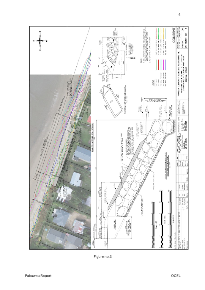
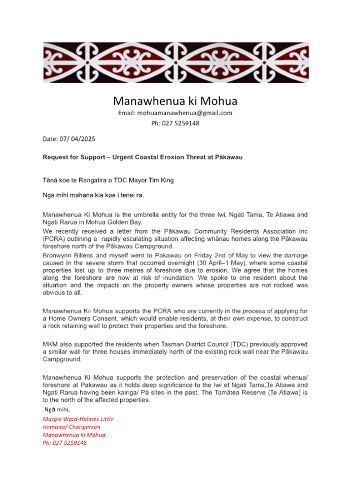
7.3 Recommendation from the Control of Alcohol in
Public Places Bylaw Hearing and Deliberations Panel
|
Report
To:
|
Tasman
District Council
|
|
Meeting
Date:
|
11
September 2025
|
|
Report
Author:
|
Cat
Budai, Community Policy Advisor
|
|
Report
Authorisers:
|
Dwayne
Fletcher, Strategic Policy Manager
|
|
Report
Number:
|
RCN25-09-7
|
1. Purpose
of the Report / Te Take mō te Pūrongo
1.1 To
consider a recommendation from the Control of Alcohol in Public Places Bylaw
Hearing and Deliberations Panel following hearing and deliberations on the
Control of Alcohol in Public Places Bylaw 2025.
2. Summary
/ Te Tuhinga Whakarāpoto
2.1 At
its 28 August 2025 meeting the Control of Alcohol in Public Places Bylaw
Hearing and Deliberations Panel resolved as follows:
That the
Control of Alcohol in Public Places Bylaw Hearing and Deliberations Panel
1. receives
the Draft Control of Alcohol in Public Places Bylaw Hearing & Deliberations
report; and
2. receives and considers all 6 submissions on the Draft Control of Alcohol in Public Places
Bylaw received by 14 July 2025; and
3. declines to accept any late Control of Alcohol in
Public Places Bylaw submissions received after 5.00pm on 15 July 2025; and
4. In
accordance with section 155 of the Local Government Act 2002:
4.1 Agrees
that a Bylaw is the most appropriate means of addressing the perceived problem
of crime and disorder cause or made worse by the consumption of alcohol in
public places; and
4.2 Agrees
that the draft Control of Alcohol in Public Places Bylaw is the most
appropriate form of bylaw for managing crime and disorder that is caused or
made worse by the consumption of alcohol in public places; and
4.3 notes
that the draft Control of Alcohol in Public Places Bylaw
does not give rise to any implications under the New Zealand Bill of Rights Act
1990; and
5. In
accordance with section 147A of the Local Government Act 2002 the Panel is
satisfied that for each of the proposed public places contained in the draft
Control of Alcohol in Public Places Bylaw there is evidence that a high level
of crime or disorder is likely to arise if the bylaw is not made; and
6. agrees
that the Draft Control of Alcohol in Public Places Bylaw (Attachment 1 to the
agenda report) and the Control of Alcohol in Public Places Bylaw Hearing and
Deliberations Panel’s recommendations be presented to the Full Council
for consideration and making at its meeting on 11 September 2025; and
7. delegates
authority to the Control of Alcohol in Public Places Bylaw Hearing and
Deliberations Panel Chair and the Chief Executive Officer to approve any minor
changes or minor editorial changes to the draft Control of Alcohol in Public
Places Bylaw 2025, prior to being submitted to Tasman District Council.
2.2 Link to the agenda and recording
for the 28 August 2025 Control of Alcohol in Public Places Bylaw Hearing and
Deliberations meeting.
2.3 Link to the minutes of the 28 August 2025 Control
of Alcohol in Public Places Bylaw Hearing and Deliberations meeting.
3. Recommendation/s
/ Ngā Tūtohunga
That the Tasman
District Council
1. receives
the recommendation from the Control of Alcohol in Public Places Bylaw Hearing
and Deliberations Panel, report RCN25-09-7; and
2. in
accordance with section 155 of the Local Government Act 2002:
a. agrees
that the proposed Tasman District Council Control of Alcohol in Public Places
Bylaw 2025 is the most appropriate form of bylaw for addressing perceived
problems in relation to crime and disorder that is caused or made worse by the
consumption of alcohol in public places; and
b. notes
that the proposed Tasman District Council Control of Alcohol in Public Places
Bylaw 2025 does not give rise to any implications under the New Zealand Bill of
Rights Act 1990; and
2. pursuant
to section 147 of the Local Government Act, makes the Tasman District Council
Control of Alcohol in Public Places Bylaw 2025 (Attachment 1 to the agenda
report) with effect from 23 October 2025; and
3. delegates
authority to the Chief Executive Officer and the Control of Alcohol in Public
Places Bylaw Hearing and Deliberations Chairperson
to approve any minor amendments to the Tasman District Council Control of
Alcohol in Public Places Bylaw 2025, prior to it being publicly notified; and
4. authorises
staff to publicly notify the Tasman District Council Control of Alcohol in
Public Places Bylaw 2025 and the date it has effect from; and
5. notes
that the Tasman District Council Control of Alcohol in Public Places Bylaw 2025
will need to be reviewed before 11 September 2030; and
6. confirms
the minutes of the 28 August 2025 Draft Control
of Alcohol in Public Places Bylaw Hearing and Deliberations meeting as a true
and correct record.
|
1.⇩
|
Control of
Alcohol in Public Places Bylaw 2025
|
88
|
7.4 Recommendation from the Responsible Camping
Bylaw Hearing and Deliberations Panel - Responsible Camping Bylaw Hearing and
Deliberations
|
Report
To:
|
Tasman
District Council
|
|
Meeting
Date:
|
11
September 2025
|
|
Report
Author:
|
Amy
Smith, Community Policy Advisor
|
|
Report
Authorisers:
|
Dwayne
Fletcher, Strategic Policy Manager
|
|
Report
Number:
|
RCN25-09-8
|
1. Purpose
of the Report / Te Take mō te Pūrongo
1.1 To
consider a recommendation from the Responsible Camping Bylaw Hearing and
Deliberations Panel following hearing and deliberations on the Responsible
Camping Bylaw 2025.
2. Summary
/ Te Tuhinga Whakarāpoto
2.1 At
its 28 August 2025 meeting the Responsible Camping Bylaw Hearing and
Deliberations Panel resolved as follows:
That the
Submissions Hearing and Deliberations Panel:
1. receives
the Draft Responsible Camping Bylaw Hearing and Deliberations report; and
2. receives and considers all 58 submissions on the Draft Responsible Camping Bylaw received by 14
July 2025; and
3. agrees to staff amending wording, for the reasons set
out in ‘Table 1: Changes proposed in response to feedback in
submissions’ (Attachment 3 to the agenda report), in the follow clauses:
3.1 Schedule 1: Prohibited Areas for Freedom Camping (typo
corrected)
3.2 Schedule 1: Prohibited Areas for Freedom Camping
(Taupata Point added)
3.3 Schedule 1: Prohibited Areas for Freedom Camping
(Staples Street added)
3.4 Schedule 1: Prohibited Areas for Freedom Camping
(George Quay Boat Ramp added); and
4. agrees
to staff amending the wording, for the reasons set out in ‘Table 2: Other
changes proposed by staff’ (Attachment 3 to the agenda report), in the
follow clauses:
4.1 Title and commencement (commencement date added)
4.2 Schedule
1: Prohibited Areas for Freedom Camping (weblink added)
4.3 Schedule
1: Prohibited Areas for Freedom Camping (location names corrected)
4.4 Schedule
1: Prohibited Areas for Freedom Camping (all maps updated)
4.5 Schedule
2: Restricted Areas for Freedom Camping (weblink added)
4.6 Schedule 2: Restricted Areas for Freedom Camping
(location names corrected)
4.7 Schedule 2: Restricted Areas for Freedom Camping (all
maps updated); and
5 agrees
that:
5.1 the
recommended changes to the draft Responsible Camping Bylaw are within the scope
of decisions that can be made following consideration of views presented during
consultation; and
5.2 in
accordance with Council’s Significance and Engagement Policy further
consultation is not required on the recommended changes; and
6 agrees
that, in accordance with section 11 of the Freedom Camping Act 2011,
restricting or prohibiting freedom camping in defined local authority areas
under the Tasman District Council Responsible Camping Bylaw (Attachment 4 to
the agenda report), is:
6.1 necessary
for one or more of the following reasons: to protect areas in the Tasman
District, to protect the health and safety of people who may visit those areas
in the District, and to protect access to those areas; and
6.2 the
most appropriate and proportionate way of addressing the perceived problems in
relation to freedom camping in local authority areas; and
6.3 not
inconsistent with the New Zealand Bill of Rights Act 1990; and
7 agrees
that the Draft Responsible Camping Bylaw (Attachment 4 to the agenda report)
and the Responsible Camping Bylaw Hearing and Deliberations Panel’s
recommendations be presented to the Full Council for consideration and making
at its meeting on 11 September 2025; and
8 delegates
authority to the Responsible Camping Bylaw Hearing and Deliberations Panel
Chair and the Chief Executive Officer to approve any minor changes or minor
editorial changes to the Responsible Camping Bylaw 2025, prior to being
submitted to Tasman District Council; and
9 notes
that the updated Site Assessments (Attachment 5 to the agenda report) will be
published on the Council’s website, as supporting information to the
Bylaw.
2.2 Link to the agenda and recording
for the 28 August 2025 Responsible Camping Bylaw Hearing and Deliberations
meeting.
2.3 Link
to the minutes of the 28 August 2025 Responsible Camping
Bylaw Hearing and Deliberations meeting.
3. Recommendateion/s
/ Ngā Tūtohunga
That the Tasman
District Council
1. receives
the Recommendation from the Responsible Camping Bylaw Hearing and Deliberations
Panel - Responsible Camping Bylaw Hearing and Deliberations report, RCN25-09-8;
and
2. agrees that, in
accordance with section 11 of the Freedom Camping Act 2011, the proposed
Tasman District Council Responsible Camping Bylaw 2025 (Attachment 1
to the agenda report)
is:
a. necessary
for one or more of the following reasons: to protect areas in the Tasman
District, to protect the health and safety of people who may visit those areas
in the district, and to protect access to those areas; and
b. the
most appropriate form of bylaw for addressing perceived problems in relation to
freedom camping in local authority areas; and
c. is
not inconsistent with the New Zealand Bill of Rights Act 1990; and
3. approves
the revocation of the Tasman District Council Freedom Camping Bylaw 2017
effective from 1 November 2025; and
4. pursuant
to sections 11 and 11A of the Freedom Camping Act 2011, makes the Tasman
District Council Responsible Camping Bylaw 2025 (Attachment 1 to
the agenda report), with effect from 1 November 2025; and
5. delegates
authority to the Chief Executive Officer and the Responsible Camping Bylaw
Hearing and Deliberations Chairperson
to approve any minor amendments to the Tasman District Council Responsible
Camping Bylaw 2025 (Attachment 1 to the agenda report), prior to it being
publicly notified; and
6. authorises
staff to publicly notify the Tasman District Council Responsible Camping Bylaw
2025 (Attachment 1 to the agenda report) and the date it has effect from; and
7. notes
that the Tasman District Council Responsible Camping Bylaw 2025 (Attachment 1
to the agenda report) will need to be reviewed before 11 September 2030; and
8. notes
that the Freedom Camping Site Assessments July 2025 (Attachment 2 to the agenda
report) will be published on the Council’s website, as supporting
information to the Responsible Camping Bylaw 2025; and
9. confirms
the minutes of the 28 August 2025 Responsible
Camping Bylaw Hearing and Deliberations meeting as a true and correct record.
|
1.⇩
|
Responsible
Camping Bylaw 2025
|
124
|
|
2.⇩
|
Freedom
Camping Site Assessments - July 2025
|
162
|
7.5 Temporary Road Closures
Decision Required
|
Report
To:
|
Tasman
District Council
|
|
Meeting
Date:
|
11
September 2025
|
|
Report
Author:
|
Tania
Brown, Road Network Coordinator
|
|
Report
Authorisers:
|
Jamie
McPherson, Transportation Manager
|
|
Report
Number:
|
RCN25-09-9
|
1. Purpose
of the Report / Te Take mō te Pūrongo
1.1 This
report seeks the Council’s approval for temporary road closures for
upcoming local events.
2. Summary
/ Te Tuhinga Whakarāpoto
2.1 The
proposed road closures are for the following
2.1.1 Annual Phil Fiddymont Memorial Rally Sprint Saturday 1
November 2025 with a postponement date Sunday 2 November 2025.
2.1.2 Annual Westland Car Rally, Matakitaki Road between
1.48km – 11.48km, Murchison, Saturday 6 December 2025.
2.1.3 Annual Richmond Santa Parade Sunday 7 December 2025 with
a postponement date of Sunday 14 December 2025.
2.1.4 Annual Motueka Starlight Christmas Parade Friday 12
December 2025.
2.1.5 Annual Richmond Market Day,
Monday 29 December 2025.
3. Recommendation/s
/ Ngā Tūtohunga
That the Tasman
District Council
1. receives
the Temporary Road Closures report, RCN25-09-9; and
2. approves the following temporary road closures:
a. Dovedale
Road from Dove Creek Bridge to end at Pigeon Valley Road (RP16.5 to 19.99)
(unsealed section) and Pigeon Valley Road from Sharp Road to end at Dovedale
Road (RP5.28 to 10.73) (unsealed section), for the Annual Nelson Car Club Phil
Fiddymont Memorial Rally Sprint on Saturday 1 November 2025,
9.00am – 5.00pm, with a postponement date of Sunday 2 November 2025.
b. Matakitaki
Road Murchison, from 1.48km from the start for ten (10) kilometres (RP 1.48
– RP 11.48), for the Westland Car Club Rally, on Saturday 6 December
2025, 7.00am – 7.00pm.
c. Richmond
Unlimited for the Richmond Santa Parade, Edward Street, Queen Street (from
Edward Street to McIndoe Place), Wensley Road (from Queen Street to John Wesley
Lane), McIndoe Place, Oxford Street (from Queen Street to Crescent Street),
Salisbury Road (from Queen Street to Talbot Street) on Sunday 7 December 2025,
7.00am – 3.00pm, with a postponement date of Sunday 14 December 2025.
d. Motueka
Starlight Christmas Parade, Wallace Street from High Street to Decks Reserve
carpark entrance on Friday 12 December 2025 3.00pm – 9.00pm (noting that
New Zealand Transport Agency administer a temporary closure of High Street from
Poole Street to Whakarewa Street); and
e. Richmond
Unlimited Market Day, Queen Street between John Wesley Lane and McIndoe Place,
Richmond, Monday 29 December 2025, 4.00am – 6.30pm.
4.1 As
specified in the Local Government Act 1974 section 342 and schedule 10,
temporary road closures for events can only be approved by the Council or a
delegated Committee of the Council.
Nelson Car Club - Phil Fiddymont Memorial Rally Sprint.
4.2 The
Nelson Car Club has applied to temporarily close part of Dovedale Road and
Pigeon Valley Road on Saturday 1 November 2025 from 9.00am to 5.00pm with a
postponement date Sunday 2 November 2025. The closure will be Dovedale Road
from Dove Creek Bridge to Pigeon Valley Road; and Pigeon Valley Road from Sharp
Road to the end at Dovedale Road.
4.3 This
route has been used in previous years for this event.
4.4 The
rally will be conducted under the provisions of the Motorsport New Zealand
National Sporting Code and its Appendices and Schedules including all event
Supplementary Regulations and Safety Plans. Motorsport New Zealand will issue
an Event Permit for the event upon application which includes Public Liability
Insurance.
4.5 This
proposed closure is also in accordance with the Transport (Vehicular Traffic
Road Closure) Regulations 1965.
4.6 The
proposed closure was advertised in Newsline on 22 August 2025, and on the
Tasman District Council’s website.
4.7 There
are no residents residing on the proposed road closure, the nearest dwelling is
approximately 500 – 800m from the road closure.
4.8 As
at the time of writing this report, no objections have been received. Staff
will update the Council on any objections received after this report was
prepared.
4.9 The New Zealand Police have
been advised of the proposed closure and have no objections.
4.10 A
Traffic Management Plan will need to be submitted by the applicant and approved
by the Council’s Road Corridor Manager before the event can take place.
4.11 If
the temporary road closure is approved, pre-and post-inspections will be
carried out by the Council’s roading contractor and any maintenance that
needs to be carried out to the road after the event will be charged back to the
Nelson Car Club.
4.12 The
Nelson Car Club holds public liability Insurance with a liability limit of
$10,000,000.
4.13 Staff
recommend that this temporary road closure is approved.
Westland Car
Club – Car Hill Climb
4.14 The
Westland Car Club has applied to temporarily close 10km of Matakitaki Road from
1.48km from the start (RP 1.48 – RP 11.48) from 7.00am to 7.00pm on
Saturday
6 December 2025 for the Westland Car Club rally event.
4.15 This
route has been used, and the closure has been approved in previous years.
4.16 The
proposed closure was advertised in Newsline on 25 July 2025 and on the Tasman
District Council’s website.
4.17 As
at the time of writing this report, one objection has been received. Staff will
update the Council on any objections received after this report was prepared.
4.18 The
nature of the objection related to resident access during the event. This issue
has been raised with the applicant and better accommodations for resident
access during the event will be included in the Traffic Management Plan. The
applicant has been advised that they must let residents and milk tankers
through the closure area between races.
4.19 If
the temporary road closure is approved, pre- and post-inspections will be
carried out by the Council’s roading contractor and any maintenance that
needs to be carried out to the road after the event will be charged back to the
Westland Car Club.
4.20 The
New Zealand Police have been advised of the proposed closure and have no
objections.
4.21 A
Traffic Management Plan will need to be submitted by the applicant and approved
by the Council’s Road Corridor Manager before the event can take place.
4.22 The
applicant will deliver a letter advising of the closure to affected residents
at least one week before the event, evidence of this to be sent to Tasman
District Council.
4.23 Emergency
services will be advised by the Westland Car Club Committee of the closure and
provide full access as needed.
4.24 The
Westland Car Club rally will be conducted under the provisions of the
MotorSport New Zealand National Sporting Code and its Appendices and Schedules
including all event Supplementary Regulations and Safety Plans. MotorSport New
Zealand will issue an Event Permit for the event upon application which
includes Public Liability Insurance.
4.25 The
proposed road closure is also in accordance with the Transport (Vehicular
Traffic Road Closure) Regulations 1965.
4.26 Staff
recommend that this temporary road closure is approved.
Richmond
Unlimited – Richmond Santa Parade
4.27 Richmond
Unlimited proposes to close Edward Street, parts of Queen Street, Wensley Road,
Oxford Street, Salisbury Road, and McIndoe Place, on Sunday 7 December 2025,
7.00am-3.00pm with a postponement date of Sunday 14 December 2025 for the
Richmond Santa Parade.
4.28 This
route has been used in previous years for the Parade.
4.29 The
proposed closure for the Richmond Santa Parade was advertised in Newsline on
11 July 2025 and on the Tasman District Council’s website.
4.30 There
will be proposed bus route changes introducing temporary stops on Talbot
Street.
4.31 A
road closure will be in place and fully managed by a qualified Traffic
Management Company.
4.32 The
Traffic Management Plan will be submitted and reviewed for approval by the
Council’s Road Corridor Manager.
4.33 As at the time of writing this report, no
objections have been received. Staff will update the Council on any objections
received after this report was prepared.
4.34 The
New Zealand Police and the New Zealand Transport Agency have been advised of
the proposed closure and have no objections.
4.35 Staff
recommend that this temporary road closure is approved.
Starlight Christmas Parade Motueka
4.36 For
the Starlight Christmas Parade on Friday, 12 December 2025, Motueka Events
Charitable Trust proposes to close the following local roads (in addition to
closure of High Street from Poole Street to Whakarewa Street which is a State
Highway administered by Waka Kotahi) Wallace Street from High Street to Decks
Reserve Carpark entrance, from 3:00pm to 9:00pm.
4.37 This route has been used in previous
years for the parade.
4.38 The
proposed closure for the Starlight Christmas Parade was advertised in Newsline
on
11 July 2025, and on the Tasman District
Council’s website.
4.39 The
New Zealand Police and the New Zealand Transport Agency have been advised of
the proposed closure and have no objections.
4.40 The
Traffic Management Plan will be submitted and reviewed for approval by the
Council’s Road Corridor Manager.
4.41 A
road closure will be in place and fully managed by a qualified Traffic
Management Company.
4.42 As at the time of writing this report, no
objections have been received. Staff will update the Council on any objections
received after this report was prepared.
4.43 The
emergency services have been advised of the proposed closures and have no
objections or concerns.
4.44 Staff
recommend that this temporary road closure is approved.
Richmond
Unlimited – Market Day
4.45 Richmond
Unlimited for the Richmond Market Day proposes to close Queen Street, Friday 29
December 2025, 4.00am-6.30pm.
4.46 This
closure has been approved in previous years for the Market Day.
4.47 The
proposed closure for the Richmond Market Day was advertised in Newsline on
11 July 2025, and on the Tasman District Council’s website.
4.48 There
will be proposed bus route changes introducing temporary stops on Talbot
Street.
4.49 A
road closure will be in place and fully managed by a qualified Traffic
Management Company.
4.50 The Traffic Management Plan will be
submitted and reviewed for approval by the Council’s Road Corridor
Manager.
4.51 As
at the time of writing this report, no objections have been received. Staff
will update the Council on any objections received after this report was
prepared.
4.52 The
New Zealand Police and the New Zealand Transport Agency have been advised of
the proposed closure and have no objections.
4.53 Staff
recommend that this temporary road closure is approved.
5.1 The options are outlined in the
following table:
|
Option
|
Advantage
|
Disadvantage
|
|
1.
|
Approve the proposed temporary road closures described in
this report.
|
The events can safely proceed as planned.
|
Some business owners, residents and road users may be
temporarily inconvenienced.
|
|
2.
|
Approve some of the proposed temporary road closures
described in this report.
|
Some of these events can proceed as planned.
Less effect on road users or residents.
|
Some of the events would not be able to proceed to the
disappointment of attendees.
|
|
3.
|
Decline the proposed temporary road closures described in
this report.
|
No effects on road users or residents.
|
The events would not be able to proceed as planned, to the
disappointment of attendees.
|
5.2 Option 1 is recommended.
6.1 It is a requirement that temporary road
closures for certain types of events made under Schedule 10 Clause 11(e) of the
Local Government Act 1974 come to the Council (or delegated Committee of
Council) for approval. Approval for temporary closures for certain events
cannot be delegated to Council staff.
6.2 As per clause 11 of Schedule 10 of the
Local Government Act 1974, consultation with the Police and the New Zealand
Transport Agency has been undertaken for the proposed temporary road closures.
6.3 As per clause 11(e) of Schedule 10 of
the Local Government Act 1974, the road closures will not exceed the aggregate
of 31 days for any year.
6.4 As per clause 11A of Schedule 10 of the
Local Government Act 1974, and clause 5 of the Transport (Vehicular Traffic
Road Closure) Regulations 1965, Council staff will advertise the temporary road
closures in Newsline and on the Council’s website.
7. Significance
and Engagement / Hiranga me te Whakawhitiwhiti ā-Hapori Whānui
7.1 The following table describes the level
of significance of the decision. Overall, the significance is considered low as
the effects of the closures are temporary in nature, and appropriate engagement
has taken place with affected parties.
|
|
Issue
|
Level of
Significance
|
Explanation of
Assessment
|
|
1.
|
Is there a high level
of public interest, or is decision likely to be controversial?
|
Moderate
|
The Nelson and
Westland Car Clubs run a series of events and have done so for many years.
The Christmas Parades and Richmond Market Day are all well attended and part
of a loved tradition that are well supported and attended by the community.
|
|
2.
|
Are there impacts on
the social, economic, environmental or cultural aspects of well-being of the
community in the present or future?
|
Low
|
As above.
|
|
3.
|
Is there a
significant impact arising from duration of the effects from the decision?
|
Low
|
The Nelson and
Westland Car Club rally event is for one day only and if there are any
effects on the network the Clubs will remedy these. The Christmas Parades and
Market Day are well supported community events that are short in duration and
will have no lasting effects on the roading network.
|
|
4.
|
Does the decision
relate to a strategic asset? (refer Significance and Engagement Policy for
list of strategic assets)
|
Low
|
The Council’s
roading network is considered a strategic asset but this decision only
relates to the temporary closures of small sections of the network for a
short duration.
|
|
5.
|
Does the decision
create a substantial change in the level of service provided by Council?
|
No
|
|
|
6.
|
Does the proposal,
activity or decision substantially affect debt, rates or Council finances in
any one year or more of the LTP?
|
No
|
|
|
7.
|
Does the decision
involve the sale of a substantial proportion or controlling interest in a CCO
or CCTO?
|
No
|
|
|
8.
|
Does the
proposal or decision involve entry into a private sector partnership or
contract to carry out the deliver on any Council group of activities?
|
No
|
|
|
9.
|
Does the proposal or
decision involve Council exiting from or entering into a group of
activities?
|
No
|
|
|
10.
|
Does the proposal
require particular consideration of the obligations of Te Mana O Te Wai
(TMOTW) relating to freshwater or particular consideration of current
legislation relating to water supply, wastewater and stormwater
infrastructure and services?
|
No
|
|
8. Financial
or Budgetary Implications / Ngā Ritenga ā-Pūtea
8.1 There
are no financial or budgetary implications for this decision.
9.1 The
main risk associated with the Council decision is reputational. Nelson-Tasman
has an established motorsport community, and many events have been run in our
district. Events can bring economic and social benefits to our community.
Declining approvals for temporary road closures for these events could cause
organisers to stop organising local events, with potential negative economic
and social outcomes for some of our community.
9.2 Some
people will be inconvenienced by the temporary road closures. However, the
closures will be short in duration and are part of a strong New Zealand
tradition that is cherished and supported by the local community.
10. Climate
Change Considerations / Whakaaro
Whakaaweawe Āhuarangi
10.1 Rallying events cause emissions, although
normal daily vehicle usage on these roads also causes emissions. The potential
emissions effects resulting from the decision to either approve or not approve
the temporary road closures are impossible to calculate. Not approving the
Pigeon Valley/ Dovedale Road and Matakitaki Road closures could mean no
rallying activity occurs at all (causing nil emissions), or it may mean rally
participants travel further afield to attend a different event (causing greater
emissions). Similarly, people travelling to attend the Christmas Parades and
Market Day events will create emissions.
10.2 Overall,
the climate change effects of the proposed road closures are considered
negligible.
11. Conclusion
/ Kupu Whakatepe
11.1 The
Christmas Parades and Market Day are a positive and loved community events with
good attendance from the Tasman community.
11.2 The Nelson and Westland Car Club Rallies are part
of an annual series of events and attracts entrants and spectators from across
the region.
11.3 Temporary
road closures for these events require the Council’s approval.
11.4 Staff
recommend that the Council approve the temporary road closures in accordance
with the Local Government act 1974 section 374 and Schedule 10.
11.5 The
proposed Pigeon Valley/ Dovedale Road and Matakitaki Road temporary closures
are also in accordance with the Transport (Vehicular Traffic Road Closure)
Regulations 1965.
12. Next
Steps and Timeline / Ngā Mahi Whai Ake
12.1 If
the Council approves the proposed temporary road closures:
· Staff
will advertise the closures in Newsline, Antenno and on the Council’s
website.
· Staff
will work with eBus to provide alternative bus routes should they be required
for bus stops impacted due to temporary road closures.
· The
applicants will submit a Traffic Management Plan to the Council’s Road
Corridor Manager for approval one month before the event.
· The
Nelson and Westland Car Clubs will undertake a letter drop one week prior to
affected landowners.
· Staff
will inform emergency services of the road closure details.
Nil
7.4 Amendment to the Tasman District Council
Traffic Control Devices Register and Traffic Control Bylaw
Decision Required
|
Report
To:
|
Tasman
District Council
|
|
Meeting
Date:
|
11
September 2025
|
|
Report
Author:
|
Mike
van Enter, Senior Transportation Engineer
|
|
Report
Authorisers:
|
Jamie
McPherson, Transportation Manager; Richard Kirby, Group Manager - Community
Infrastructure
|
|
Report
Number:
|
RCN25-09-10
|
1. Purpose
of the Report / Te Take mō te Pūrongo
1.1 The
purpose of this report is to obtain the Council’s approval to make
changes to the Traffic Control Devices Register and map display, to ensure
these are enforceable under the Traffic Control Bylaw 2016.
2. Summary
/ Te Tuhinga Whakarāpoto
2.1 The
Council’s Traffic Control Bylaw 2016, and its accompanying Traffic
Control Devices Register and map display, is the mechanism for the Council to
record all authorised traffic control devices such as parking restrictions and
regulatory traffic signs.
2.2 This
report requests the Council’s approval for various changes and additions
to the Traffic Control Devices Register.
2.3 A
summary of the changes can be found in Section 5, and a diagrammatic
description of each change is in Attachment 1.
3. Recommendation/s
/ Ngā Tūtohunga
That the Tasman
District Council
1. receives
the Amendment to the Tasman District Council Traffic Control Devices Register
and Traffic Control Bylaw report RCN25-09-10; and
2. approves amendments to regulations, controls,
restrictions and prohibitions in the Traffic Control Devices Register of the
Tasman District Traffic Control Bylaw 2016 (Chapter 7 of Tasman
District’s Consolidated Bylaw) pursuant to clause 7(3) of the Bylaw, as
proposed by the Diagrammatic Descriptions and associated GIS co-ordinates in
Attachment 1 to the agenda report, with effect from 12 September 2025 or the
date the traffic control device is installed, whichever is later; and
3. notes that the Traffic Control Devices Register of the
Traffic Control Bylaw 2016 will be updated accordingly
4.1 The Council’s Traffic Control
Bylaw enables the Council to establish, alter or remove traffic control devices
by resolution, amending the Traffic Control Devices Register and map display.
4.2 Parking restrictions and certain
regulatory Traffic Control Devices are managed through this bylaw. Changes
require a resolution of the Council to become legally enforceable.
4.3 Consultation should be appropriate and
in accordance with the Local Government Act Section 82, which sets out the
principles of consultation. The consultation principles include:
4.3.1 That persons who will or may be affected by, or have an
interest in, the decision or matter should be provided by the local authority
with reasonable access to relevant information in a manner and format that is
appropriate.
4.3.2 The nature and significance of the decision or matter,
including its likely impact from the perspective of the persons who will or may
be affected by, or have an interest in, the decision or matter.
4.3.3 The costs and benefits of any consultation process or
procedure.
4.4 Some of the proposed Traffic Control
Device changes are considered to have minor or very isolated effects. Where the
effects are considered isolated, consultation is typically via letter inviting
feedback from adjacent property owners and businesses.
5. Analysis
and Advice / Tātaritanga me ngā tohutohu
Recreational Parking Management
5.1 Manoy Street - New no parking
restriction clarifying the intent of the recent Talbot Street to Manoy Street,
keeping the path entrance free from parked cars.
5.1.1 No new consultation has been undertaken. The recent project to
construct the shared path was appropriately consulted on and included the
shared path link to the car park area adding the no-parking signs
clarifies the intention of the path, that it is not parked on.
Residential Parking Management
5.2 Salisbury Road – Remove no
parking restriction to reinstate parking. Removing the concrete
separators form the on-road cycle lanes reduces the width requirement,
allowing parking to be reinstated. The layout change will be co-ordinated with
a programmed reseal.
5.2.1 Feedback was sought from
immediately adjacent property owners and occupiers. One response was received
in support of the changes.
5.3 Croucher and Chisnall Streets -
Install P120 time limited parking between 8am to 6pm Monday to Friday to 10
unrestricted spaces to allow the spaces to be used as visitor parking for the
surrounding residential area.
5.3.1 High all day parking demand in this area from Richmond
town centre activities means residential on-road visitor parking is not
currently available in this area.
5.3.2 Residents in Croucher and
Chisnall Streets were canvased for their view on issues with parking in the
area and encouraging them to suggest changes. Four submissions were received
with various suggestions.
5.3.3 The proposed parking changes
were developed and feedback sought. Three submissions were received with none
opposing the proposed changes.
Bus Stops
5.4 Poole Street – Relocate
existing bus stop from outside number 29 and 31 Poole Street to outside 23 and
25 Poole Street. This was requested by the bus service operator due to the risk
posed by an electrical pole at the existing stop.
5.4.1 The property owners
affected by the proposed Bus stop were consulted. One submission was received
citing that their property amenity would be affected.
5.4.2 The Bus Stop is proposed in this
position due to it being screened by vegetation and fences of both properties.
The length of the Bus stop including tapers fits within the distance between
the two properties driveways.
5.5 Atkins
Street – New Bus stops on Atkins Street.
5.5.1 As part of the review of the service, it was recognised
that as demand for the service grows, so will the need for more stops. There is
approximately 1.3km between the Bus Stops in Poole Street and Grey Street,
where the bus route traverses through a lot of residential area.
5.5.2 Consultation was carried out with nearby residents with
several concerned about the effect that the stop outside their property would
have on their property's amenity.
5.5.3 Bus Stop locations are determined by firstly locating
them where there is sufficient length of road to accommodate the stop including
the pull-in and exit tapers, while located in a safe place with good
sightlines.
5.5.4 Ideally, the stop location best suits a site where there
is either a high fence or vegetation to screen the Bus stop.
5.5.5 Initially, the North bound stop had been proposed
outside the empty corner section near Pã Street however, the landowner
indicated they wanted to develop this land and maintain their options for
siting future accessways.
5.5.6 The proposal attached and recommended for implementation
was consulted on recently with no objections received.
5.6 Whitby
Road – New Bus stops on Whitby Road.
5.6.1 Residents
in the Spring Grove area at the eastern end of Wakefield, requested Bus
Stops in the section of SH6 near Bird Lane.
5.6.2 Consultation was carried out, with one resident voicing
concern about the effect that a Bus stop outside their property would have on
its amenity and privacy.
5.6.3 The proposed Bus Stops were located where they would fit
between vehicle accessways without affecting sightlines and limiting the loss
of roadside parking.
5.6.4 Those properties affected by the proposed Bus stops have
good road boundary fencing and screening to provide privacy for both residents
and bus patrons.
5.7 Aporo
Road – New Bus stops on Aporo Road.
5.7.1 Residents in the area requested Bus Stops on Aporo Road
in the proximity of Marriages Road.
5.7.2 Consultation was carried out with residents and a copy
of the proposal sent to the Tasman Area Community Association for comment.
5.7.3 Some residents asked if the Bus Stop could be at Deck
Road. At Deck Road, the eastern side berm is narrow due to the road boundary
being close to the seal edge along with a deep drain that would need realigning
leaving bus patrons with little room to stand unless the bus was to stop
partially out in the traffic lane. The speed limit in this area is 80km/h.
5.7.4 The proposed Bus Stop locations near Marriages Road,
have wide existing seal shoulders with good sightlines. There is room on the
eastern side berm to extend out the shoulder to accommodate a Bus shelter.
5.7.5 The seal layby on the western side is also used by the
School Bus, where there is an existing shelter.
6. Financial
or Budgetary Implications / Ngā Ritenga ā-Pūtea
6.1 The cost of installing the proposed
traffic control devices and bus stops is estimated to be $21,000.
6.2 The cost of installing the proposed
traffic control devices, and updating the register, will be met from existing
public transport infrastructure budgets.
6.3 Line marking typically requires a
re-mark once every two years. Adding to the line marking will incrementally
increase maintenance costs and contribute to increased future budgets.
6.4 Small signs typically have a 10-year
design life but may last much longer. Adding more signs will increase future
demand on renewals budgets.
7.1 The options are outlined in the
following table:
|
Option
|
Advantage
|
Disadvantage
|
|
1.
|
Approve changes proposed in the report
and in Attachment 1 to the agenda report.
This is the recommended option.
|
Improved public transport service.
Increased on-road parking on Salisbury
Road.
Positive feedback from the community who
requested changes.
|
Minor reduction in on-road parking at bus
stop locations.
Minor increase in walking distance to
all-day parking spaces for town centre all day parking demand.
Modest cost of installing changes.
|
|
2.
|
Approve some of the proposed changes.
|
Some of the advantages of Option 1.
|
If changes are not approved, there could
be negative feedback from those involved in the targeted consultation that
was undertaken.
|
|
3.
|
Do not approve the proposed changes.
|
No cost.
|
No improvement in public transport
service.
No increased parking on Salisbury Road.
No improved residential visitor parking
in the Croucher and Chisnall Streets area.
|
7.2 Option 1 is recommended.
8.1 The proposed changes meet the
requirements of the Tasman District Council Traffic Control Bylaw 2016
9. Iwi
Engagement / Whakawhitiwhiti ā-Hapori Māori
9.1 No specific iwi engagement has occurred
for the changes. These changes are relatively minor operational issues and
isolated in effects.
10. Significance
and Engagement / Hiranga me te Whakawhitiwhiti ā-Hapori Whānui
10.1 The following table describes the level of
significance of this decision. Overall, the level of significance is considered
low as the changes are generally minor and staff have consulted with directly
affected residents, businesses, and stakeholders.
|
|
Issue
|
Level of
Significance
|
Explanation of
Assessment
|
|
1.
|
Is there a high level
of public interest, or is decision likely to be controversial?
|
Low
|
Changing road layouts
and adding public transport can create a high level of interest, particularly
on more highly trafficked roads.
This decision affects
a relatively small number of roads in the District.
|
|
2.
|
Are there impacts on
the social, economic, environmental or cultural aspects of well-being of the
community in the present or future?
|
Low
|
Good management of
traffic controls, parking and public transport facilities can contribute
towards the success of a place; poorly managed and designed traffic controls
and parking can undermine efforts to create highly liveable urban areas.
The parking
restrictions proposed are to address issues identified.
|
|
3.
|
Is there a
significant impact arising from duration of the effects from the decision?
|
Low
|
Traffic control
devices are not permanent and can be changed if required.
|
|
4.
|
Does the decision
relate to a strategic asset? (refer Significance and Engagement Policy for
list of strategic assets)
|
Low
|
The Council’s
roading network is considered a strategic asset. The changes are intended to
improve safety and accessibility of our transport network to a variety of
user types.
|
|
5.
|
Does the decision
create a substantial change in the level of service provided by Council?
|
Low
|
|
|
6.
|
Does the proposal,
activity or decision substantially affect debt, rates or Council finances in
any one year or more of the LTP?
|
No
|
|
|
7.
|
Does the decision
involve the sale of a substantial proportion or controlling interest in a CCO
or CCTO?
|
No
|
|
|
8.
|
Does the
proposal or decision involve entry into a private sector partnership or
contract to carry out the deliver on any Council group of activities?
|
No
|
|
|
9.
|
Does the proposal or
decision involve Council exiting from or entering into a group of
activities?
|
No
|
|
|
10.
|
Does the proposal
require particular consideration of the obligations of Te Mana O Te Wai
(TMOTW) relating to freshwater or particular consideration of current
legislation relating to water supply, wastewater and stormwater
infrastructure and services?
|
No
|
|
11. Communication
/ Whakawhitiwhiti Kōrero
11.1 Letters inviting feedback have been sent to
immediately adjacent landowners and the Tasman Area Community Association. Any
feedback received is described with the attached descriptions.
12.1 Low reputational risk associated with not being
responsive to community requests and concerns.
13. Climate
Change Considerations / Whakaaro
Whakaaweawe Āhuarangi
13.1 The changes to the transport network made by these
traffic control devices are not expected to alter transport behaviour at a
level that will impact greenhouse gas emissions although increased public
transport use does can reduce transport emissions.
14. Alignment
with Policy and Strategic Plans / Te Hangai ki ngā aupapa Here me ngā
Mahere Rautaki Tūraru
14.1 The proposed traffic control device changes are
consistent with the Council’s Roading Policies and Strategies.
15. Conclusion
/ Kupu Whakatepe
15.1 The changes to traffic control devices are proposed
to ensure the safe and efficient functioning of the transport network and
improved public transport provisions.
16. Next
Steps and Timeline / Ngā Mahi Whai Ake
16.1 If the Council approves the proposed changes:
16.1.1 Staff will provide instructions to our
contractors to implement the changes required.
16.1.2 Staff will update
the Traffic Control Devices Register as soon as changes are in place.
|
1.⇩
|
Traffic
control devices diagramatic descriptions September 2025
|
231
|
7.7 Eves Valley Landfill Road Stopping
Decision Required
|
Report To:
|
Tasman District Council
|
|
Meeting Date:
|
11 September 2025
|
|
Report Author:
|
Kevin O'Neil, Senior Property Officer
|
|
Report Authorisers:
|
Richard Kirby, Group Manager - Community Infrastructure
|
|
Report Number:
|
RCN25-09-11
|
1. Purpose
of the Report / Te Take mō te Pūrongo
1.1 The purpose of this report is to obtain
the Council’s approval to the stopping of unformed legal road located
within 214 Eves Valley Road, Waimea West under the Public Works Act 1981.
2. Summary
/ Te Tuhinga Whakarāpoto
2.1 The Council owns the land at 214 Eves
Valley Road, Waimea West. This is where the Eves Valley Landfill site is
located.
2.2 The Council was approached by the Nelson
Tasman Regional Landfill Business Unit (NTRLBU), which is a joint committee
between Tasman District Council and Nelson City Council, who manage the
landfill site at 214 Eves Valley Road, Waimea West. They have asked the Council
to undertake a road stopping over a small section of unformed legal road that
encroaches into the Council’s land and then terminates part way through
the property.
2.3 The unformed legal road is part of
Golden Hills Road which encroaches approximately 370 metres into the
southeastern corner of the Council’s property and is 20 metres wide along
its entire length.
2.4 NTRLBU are proposing to stop the section
of unformed legal road that encroaches into southeastern corner of the property
comprising an area of approximately 0.7250ha.
2.5 There are no other affected adjoining
landowners. All costs of the road stopping are to be met by NTRLBU.
2.6 The plans of the proposed road stopping
are noted in Section 12 of this report.
2.7 Attachment 1 shows the property
as it stands now with the unformed legal road (highlighted in red) running
partway through the property from the southeastern corner of the property.
2.8 This is a routine decision and staff
recommend that the Council approves the road stopping, which will be subject to
final approval by Land Information New Zealand (LINZ).
3. Recommendation/s
/ Ngā Tūtohunga
That the Tasman District Council
1. receives the Eves Valley Landfill Road Stopping report, RCN25-09-11;
and
2. approves the stopping of the section of
legal road, pursuant to Section 116 of the Public Works Act, within the
property of 214 Eves Valley Road as shown highlighted red in Attachment 1 to
the agenda report, subject to the approval of Land Information New Zealand; and
3. delegates authority to the Group Manager
Community Infrastructure to undertake all processes, including the authority to
sign all relevant documentation necessary to give effect to the decision to
stop the section of legal road within the property of 214 Eves Valley Road,
Waimea West.
4.1 The Nelson Tasman Regional Landfill
Business Unit (NTRLBU) manage the landfill site on property owned by Council at
214 Eves Valley Road, Waimea West. There is an unformed section of legal road
which will impede the future use of the site. This section of legal road ends
within the property and is not connected to any other property or legal road.
4.2 The NTRLBU has identified the area of
land surrounding, and including, the area of legal road to be stopped as the
most suitable location for creation of a new “cell” for disposal of
class 3 and 4 contaminated soils. Stopping this section of road will provide
NTRLBU with a longer-term solution for landfilling contaminated soils.
4.3 The land adjoining the road stopping
area is operated as landfill for regional benefit and is designated in the
Tasman Regional Management Plan for landfill purposes D163 (Sanitary Landfill
Refuse Disposal). The section of road to be stopped will be incorporated into
the landfill designation D163. All costs in relation to this transaction will
be met by NTRLBU.
4.4 There are no other affected adjoining
landowners, and the road has never been formed nor used by members of the
public.
4.5 The road stopping will occur using the
Public Works Act 1981 which allows the road stopping to proceed without the
need for public notification. The proposal was considered by the
Council’s Road Stopping Panel and the Council’s Transportation
Manager. Council staff have also consulted with Herenga ā Nuku (Outdoor
Access Commission), Heritage New Zealand and all local Iwi on the
proposal.
4.6 Herenga ā Nuku has confirmed it
does not oppose the road stopping as public access is not being affected as
this section of road does not connect to any other legal roads nor does it
adjoin any reserve, public conservation land, waterway or provide any other
recreational opportunity.
4.7 Heritage New Zealand have confirmed
there are no heritage sites in the road stopping area.
5. Analysis
and Advice / Tātaritanga me ngā tohutohu
5.1 There is small section of unformed legal
road that partially bisects the Council’s property at 214 Eves Valley
Road. This section of legal road ends within the property and is not connected
to any other property or legal road
5.2 This property is operated as a landfill
controlled by the Nelson Tasman Regional Landfill Business Unit (NTRLBU), which
is a joint committee set up to benefit both councils located in the region.
5.3 The Nelson Tasman Regional Landfill
Business Unit (NTRLBU) have identified that the section of legal road that
partially bisects the property restricts the full utilisation of the site at
214 Eves Valley Road and have asked if this section of road could be stopped
and amalgamated into the Council’s Title.
5.4 The Road Stopping will be undertaking
using the provisions for the Public Works Act 1981.
5.5 As the property is zoned “Rural
2” if the Council agrees to progress the road stopping consent will be
required from LINZ which has delegated authority from the Minister of Lands.
5.6 A valuation will be undertaken to
determine the compensation to be paid to the Council for the road land being
stopped.
5.7 The section of road will be stopped via
gazette and the land will be amalgamated into the Council’s Title for 214
Eves Valley Road.
6. Financial
or Budgetary Implications / Ngā Ritenga ā-Pūtea
6.1 The NTRLBU is a joint committee between
the Tasman District Council and Nelson City Council. The NTRLBU will meet all
the costs involved with the road stopping, including paying compensation to the
Council (as landowner) for the approximate 0.7250 hectares of road land to be
stopped.
7.1 The options are outlined in the
following table:
|
Option
|
Advantage
|
Disadvantage
|
|
1.
|
Agree to the road stopping. (Recommended)
|
The NTRLBU will be able to use the entire
landfill site at 214 Eves Valley Road for future expansion.
|
None Identified.
|
|
2.
|
Not agree to the road stopping.
|
The shared costs of the road stopping
will be saved.
|
The existence of the unformed piece of
legal road restricts the full utilisation of the landfill site.
|
7.2 Option 1 is recommended.
8.1 As there are no other affected/adjoining
landowners the road stopping can be completed using the Public Works Act 1981,
especially as the property is used for a public work (landfill site).
8.2 This proposal does not contravene any
policy or plan.
8.3 Iwi Engagement / Whakawhitiwhiti
ā-Hapori Māori has been undertaken.
9. Significance
and Engagement / Hiranga me te Whakawhitiwhiti ā-Hapori Whānui
9.1 There is no requirement to undertake
public notification if the Public Works Act 1981 is used to complete the road
stopping. Given there will be no physical changes to the road network, this
proposal is considered of low significance and does not require community
engagement.
|
|
Issue
|
Level of
Significance
|
Explanation of
Assessment
|
|
1.
|
Is there a high level
of public interest, or is decision likely to be controversial?
|
No
|
There are no affected
adjoining landowners.
|
|
2.
|
Are there impacts on
the social, economic, environmental or cultural aspects of well-being of the
community in the present or future?
|
No
|
|
|
3.
|
Is there a
significant impact arising from duration of the effects from the decision?
|
No
|
|
|
4.
|
Does the decision
relate to a strategic asset? (refer Significance and Engagement Policy for
list of strategic assets)
|
Low
|
The entire road
network is a strategic asset. This proposal will not have any impact on the
existing road network.
|
|
5.
|
Does the decision
create a substantial change in the level of service provided by Council?
|
No
|
|
|
6.
|
Does the proposal,
activity or decision substantially affect debt, rates or Council finances in
any one year or more of the LTP?
|
No
|
|
|
7.
|
Does the decision
involve the sale of a substantial proportion or controlling interest in a CCO
or CCTO?
|
No
|
|
|
8.
|
Does the proposal or
decision involve entry into a private sector partnership or contract to carry
out the deliver on any Council group of activities?
|
No
|
|
|
9.
|
Does the proposal or
decision involve Council exiting from or entering into a group of
activities?
|
No
|
|
|
10.
|
Does the proposal
require particular consideration of the obligations of Te Mana O Te Wai
(TMOTW) relating to freshwater or particular consideration of current
legislation relating to water supply, wastewater and stormwater
infrastructure and services?
|
No
|
|
10. Communication
/ Whakawhitiwhiti Kōrero
10.1 As the road stopping will occur under the
provisions of the Public Works Act 1981, there is no requirement for public
notification. All local Iwi have been consulted about the proposed road
stopping and no issues or concerns have been raised by Iwi. Given there will be
no physical changes to the road network, this proposal is considered of low
significance.
11.1 This is a routine low risk proposal.
12. Climate
Change Considerations / Whakaaro Whakaaweawe Āhuarangi
12.1 The decision on stopping this section of legal road
does not have any impact on the changing climate and neither contributes to,
nor detracts from, the Council’s and central government policies and
commitments relating to climate change.
13. Alignment
with Policy and Strategic Plans / Te Hangai ki ngā aupapa Here me ngā
Mahere Rautaki Tūraru
13.1 We note that there is an existing designation
(D163) over 214 Eves Valley Road. This designation is for “Sanitary
Landfill Refuse Disposal”. If the road stopping proceeds this designation
will need to be extended to include the area of stopped road.
14. Conclusion
/ Kupu Whakatepe
14.1 The road stopping is of equal benefit to both the
Council and the NTRLBU. The road stopping may result in a small compensation
payment to the Council (as landowner) for the road land to be stopped.
15. Next
Steps and Timeline / Ngā Mahi Whai Ake
15.1 Within the next month the Council will enter into a
formal agreement with the NTRLBU to proceed with the road stopping. The
agreement notes that the Council cannot guarantee LINZ will approve the road
stopping.
15.2 A valuation will be undertaken to assess the
compensation that the Council is to receive for the road land to be stopped.
15.3 LINZ will be asked to approve the road stopping. If
this is approved, the land will be formally surveyed, and LINZ asked to publish
a gazette notice that stops road and amalgamates this land into the
Council’s Record of Title for 214 Eves Valley Road, Waimea West.
|
1.⇩
|
Eves
Valley Landfill - Road Stopping - Appendix One
|
245
|
7.8 Selection of the Site for the New Wakefield
Community Hub
Information Only - No Decision
Required
|
Report
To:
|
Tasman
District Council
|
|
Meeting
Date:
|
11
September 2025
|
|
Report
Author:
|
Martin
Brown, Project Manager; Grant Reburn, Reserves and Facilities Manager; Rob
Coleman, Reserves Officer - Recreation and Systems
|
|
Report
Authorisers:
|
Richard
Kirby, Group Manager - Community Infrastructure
|
|
Report
Number:
|
RCN25-09-12
|
1. Summary
/ Te Tuhinga Whakarāpoto
1.1 In The Tasman
District Council Long Term Plan 2024-2034 funding has been allocated for the
Waimea South Facilities. The main project is the new Wakefield Community Hub.
The location for the new hub was advised in the Long-Term Plan as being on the
Wakefield Domain off Collins Road.
1.2 In early 2025 a local landowner
approached the Council project team regarding part of a site at 52 Edward
Street. The site was large enough to house the planned approximate 1200m2
to 1500m2 facility and provided a viable option to explore, due to
its proximity to the centre of the township. A SWOT analysis was developed to
assess both the sites.
1.3 Two community sessions and a Shape
Tasman poll provided this information to the community for comment and
feedback.
1.4 Most comments and feedback showed the
community’s overwhelming preference for the proposed facility to remain
at the original location of the Wakefield Domain.
2. Recommendation/s
/ Ngā Tūtohunga
That the Tasman District Council
1. receives the Selection of the Site for the New Wakefield Community
Hub report RCN25-09-12; and
2. acknowledges that after the site review and community engagement,
the community overwhelmingly supported that the Wakefield Community Hub remains
at the Wakefield Domain, not the alternative site of 52 Edward Street.
3.1 With the
emergence of the alternative site, the project team required a fact-based
comparison of both sites. JTB Architects were engaged to complete a Strengths,
Weakness, Opportunities and Threats (SWOT) assessment and provided a fact-based
review for both sites.
3.2 The SWOT
analysis highlighted both sites’ benefits and weaknesses.
3.3 In summary,
Wakefield Domain allowed for much greater future expansion, interacted more
with sports codes and had more space for parking. However, it will require more
infrastructure to service and access the remote site, will likely promote car
travel over walking due to the need to cross the State Highway. Finally, to
access from Clifford Road is reliant on New Zealand Transport Agency (NZTA)
approval which will have its challenges. As such alternative established access
routes from the State highway and local roads will need to be considered.
3.4 In summary, 52
Edward Street has centre township and good walking access, close to school,
lower infrastructure and access costs, could invigorate the centre of the
township. However, only has limited expansion (maximum building area 1500m2)
much more limited car parking, and concerns raised over township traffic
increase and capacity, and has more impactful modelled inundation across the
site area. The proximity to the local pub was felt by some of the community to
be unfavourable and is closer to residential properties.
4.1 Site one
Wakefield Domain (Indicative Area)
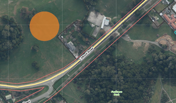
4.2 Site two 52
Edward Street
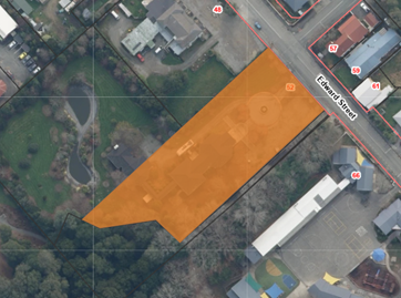
5. Community Feedback Summary
5.1 Feedback was
collected by both the Waimea South Community Facility
Charitable Trust and the Council.
5.2 The Waimea South Community Facility Charitable Trust set up two
engagement meetings. These were held in Wakefield on Tuesday 17 June 2025, in
partnership with Council staff. Further comments were also collected via the
Trust’s website. Additionally, the Trust promoted the information and
options on social and local media and Radio New Zealand.
5.3 Eighty-one (81)
responses were received from the community-driven sessions and feedback forms
most responses were from the 40+ year-old population.
5.4 The key messages
were,
· Seventy-five percent (75%) of the
responders preferred Site 1, the Wakefield Domain (Recreational Reserve) site.
· Positives for site 1 included, expansion and future proofing
opportunities and good proximity to the sports fields and facilities
· Concerns for site 1, infrastructure cost to connect the site to
mains and the SH6, safe access to the site for walking and cycling and child
access, as need to cross SH6
· Fourteen percent (14%) of the responders
preferred site 2, the 52 Edward Street Site.
· Positives for site 2 included the potential lower cost for
infrastructure and road access, transforming the current brownfield site and
having good access to the school
· Concerns for site 2 included the proximity to the hotel, parking
limitations, increased congestion risks to the township, and lack of connection
to the Sports facilities.
5.5 The Council ran
a ‘Shape Tasman’ poll from 27 May 2025 to 22 July 2025 providing
the information from the SWOT analysis with FAQs. One hundred and fifteen
(115) comments were recorded (Note* some of the community added more than
one comment and some were duplicates) – 71 responders preferred
site 1, and 26 preferred site 2.
5.6 The key messages
were,
· Positives for site 1 included, future expansion opportunity meets
the communities’ growing needs, no cost to buy the site as we already own
it, allows for sport, generous space for expansion, far batter outdoor
opportunities to connect with other uses.
· Concerns for site 1 included, potential impact of future flooding,
safety of pedestrians and cyclist access. Higher costs for infrastructure.
· Positives for site 2 included, central to the village, further away
from the flood areas, easier to connect to service and roads, use the existing
building don’t build another,
· Concerns for site 2 included, restricted shape and size of the site,
bringing extra traffic into the village, the cost to purchase the site and
demolish the building when the Council already owns site 1,
· Other comments, what will happen to the current hall? Need to look
at flooding potential at the sites after recent events, concerns a small
population get to spend so much when lots of work required on rivers. The
Council has too much debt so should not be doing this project. Why is the
decision going to be based on a small number of responses? The village has more
halls than it can use and doesn't need another. Tasman District Council is in
too much debt and now has a flood to clean up.
6.1 With the
overwhelming community support for the Wakefield Domain
(Recreational Reserve) site, the landowner of 52 Edward
Street has been thanked and notified of the outcome from their approach.
6.2 The
Council’s project team is now focused on the project initiation for the
new hub on the Wakefield Domain site.
6.3 The next steps
will involve site investigations, infrastructure and services review.
Additionally, the project team is working on the road access and will be
liaising with NZTA.
6.4 With the site
confirmed we will be liaising with our iwi partners on the planned kaupapa.
6.5 The project team
will be working with the community representatives and stakeholders to develop
requirements for the new hub as part of the Design and Build Procurement
planning.
Nil
7.9 Confirmation of the Location for the new
Tapawera Community Hub
Decision Required
|
Report
To:
|
Tasman
District Council
|
|
Meeting
Date:
|
11
September 2025
|
|
Report
Author:
|
Martin
Brown, Project Manager; John Ridd, Group Manager - Service and Strategy;
Grant Reburn, Reserves and Facilities Manager
|
|
Report
Authorisers:
|
Richard
Kirby, Group Manager - Community Infrastructure
|
|
Report
Number:
|
RCN25-09-13
|
1. Purpose
of the Report / Te Take mō te Pūrongo
1.1 To
seek formal approval from the Council to develop the new Tapawera Community Hub
within the Tapawera Memorial Park, north of Matai Crescent, area 3 on the
aerial plan provided within this report.
1.2 Noting
the site proposed, in the adopted Long-Term plan, was 95 Main Road Tapawera,
site of the Tapawera Community Council Community Centre and Opportunity (OP)
Shop.
2. Summary
/ Te Tuhinga Whakarāpoto
2.1 When
the new Community hub in Tapawera was proposed, approved and adopted in the
2024/34 Long-Term Plan its location was planned to be at 95 Main Road Tapawera.
A site not owned by the Council and was to be purchased by the Council.
2.2 Due
diligence for the purchase of 95 Main Road Tapawera raised several issues and
constraints with the site. This led the project team, with the community and
the Parks and Reserves Team to look at other viable sites.
2.3 In
total three further sites were identified as shown below (noting Site 4 was the
original site, 95 Main Road Tapawera).
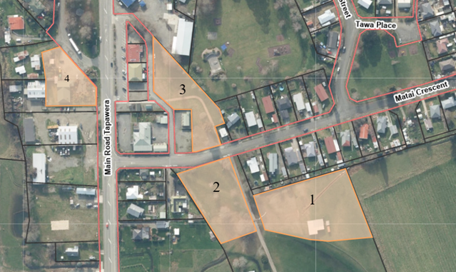
2.4 Two
workshops were held with the Council in respect of all the sites and a SWOT
analysis has been conducted to understand the benefits and constraints of all
four sites.
2.5 Sites
1 to 3 (all Council reserve land) were also considered as part of the Reserves
Management Plan review process, noting that site 4 was not owned by the Council
so was not part of the review.
2.6 As
part of the Reserves Management Planning Process (RMP), consultation was
completed in June 2025. Comments and feedback were gathered on which of the
three reserves was preferred for the location of the new Tapawera Community
Hub.
2.7 The
adopted Reserves Management Plan for the Lakes Murchison Ward RMP stated. Allow
the new Tapawera Community Hub to be constructed on parcel (a) of Tapawera
Memorial Park, at the location labelled in the above image as Option 3 (i.e.
north of Matai Crescent).
2.8 Whilst
the Lakes Murchison Ward RMP has been adopted on 14 August 2025, there is no specific mention of the hub in the resolutions. This
is a material change to the adopted Long-Term Plan 2024 to 2034, as such the
project team is seeking formal approval to construct the Hub within the
Tapawera Memorial Park, north of Matai Crescent (area 3 on the aerial image
above).
3. Recommendation/s
/ Ngā Tūtohunga
That the Tasman
District Council
1. receives
the Confirmation of the Location for the new Tapawera Community Hub report,
RCN25-09-13; and
2. approves the location for the future
Tapawera Community Hub within the Tapawera Memorial Park, a Council reserve,
north of Matai Crescent, shown as area 3 on the aerial plan provided within
this report.
4.1 The
Tapawera Hub Project was adopted in the 2024/2034 Long Term Plan.
4.2 A
budget of $2.68 million has been allocated, including $900,000 of community
funding, to develop a Community Hub in Tapawera. (Around $500,000 has already
been provided to the community in the form of funding from the Department of
Internal Affairs).
4.3 Due
diligence on the proposed site, 95 Main Road Tapawera, raised several
constraints (including site and building not owned by the Council, divided
community over the ‘historic’ nature of the building, other
buildings and powerlines located on the site limiting its usable area). As a
result, these other sites were considered and reviewed as part of the Reserves
Management Plan Review process with a SWOT analysis (Strengths, Weaknesses,
Opportunities and Threats) to provide more information on the Council owned
land being considered.
4.4 Three Council owned reserves were
considered against the original proposed site. These reserves were also
considered as part of the Lakes Murchison Reserves Management Plan (RMP), and
consultation was undertaken with the community.
4.5 The hearings and deliberations, as part
of the RMP review process, resulted in the preferred site option of site 3 and
this was adopted within the Lakes Murchison Reserves Management Plan.
5. Analysis
and Advice / Tātaritanga me ngā tohutohu
5.1 The
Long-Term Plan 2024/2034 adopted the project based on the new hub being located
at 95 Main Road, Tapawera.
5.2 The
intention is to now build in a different location. The new location is within a
Council Reserve, as a result the project team needs to seek the Council’s
approval for this change of location from that in the adopted Long-Term Plan
2024/2034 and to construct the building on the Council Reserve.
5.3 From
the discussions with the community groups, with the consultation as part of the
Reserves Management Plan review process, site 3 has garnered good general
support. The following points provide the key factors considered for each of
the sites.
· Site
1 - Gazetted under the Reserves Act 1977, subject to a low level of inundation,
limited-service infrastructure in place and potential impacts to adjacent
residential properties and the shearing sheds.
· Site
2 – Not Gazetted under the Reserves Act 1974, Fee simple reserve land,
subject to more significant inundation, some limited-service infrastructure in
place and potential impacts to adjacent residential property.
· Site
3 – Not Gazetted under the Reserves Act 1974, Fee simple reserve land, no
inundation modelled to the area where the hub is planned to be located, small
service infrastructure works required but mostly in place, central to the
township with connectivity to shops, toilets, recreational reserve with skate
park and playground.
· Site
4 – 95 Main Road, Tapawera had constraints including, local division over
removal of the existing building, other heritage artifacts placed on the site,
the Kahurangi Waharoa, overhead powerlines, the cost of purchasing the land and
ratifying agreements with all other interested parties and anecdotal boundary
encroachments.
5.4 The SWOT analysis and indicative
estimates undertaken by third-party consultants has highlighted that site 3
provides the best opportunity to get best value for the community. Highlighting
site 3 should provide the most cost-effective options to develop the Hub.
6. Financial
or Budgetary Implications / Ngā Ritenga ā-Pūtea
6.1 The move to the alternative site does
not impact the projects’ incumbent financial risk any more than the
original proposed site.
6.2 The existing financial and budgetary
risks remain the same and relate to the community funded element ($900,000) and
the annual maintenance and running costs for the life of the facility.
7.1 The options are outlined in the
following table:
|
Option
|
Advantage
|
Disadvantage
|
|
1.
|
Locate the new Tapawera Community Hub on
site 3.
(Recommended)
|
The site is centrally located between
amenities (public toilets and skatepark/playground).
Lower initial infrastructure connection
costs as all services are near the site.
Has limited to no inundation modelled
across the site.
The community generally supports this
location over the other two sites.
|
No road frontage.
Lacks room for significant expansion,
though could have some expansion over its life.
Will require realignment of the existing
Tasman’s Great Taste Trail.
Will reduce the green space in the
central township, but there are many green spaces close to the township.
|
|
2.
|
Locate the new Tapawera Community Hub on
site 2.
|
Has road frontage.
Has more room for expansion and could tie
into the rugby rooms if it was desired.
|
Has a moderate level of modelled
inundation across the site (300 to 700mm).
Will require additional infrastructure to
connect to the mains (three waters, power and data).
|
|
3.
|
Locate the new Tapawera Community Hub on
site 1.
|
Has significant room for future expansion
and could tie in to the rugby club if it was desired.
Ties in with the rugby field and sports
areas.
|
No road frontage.
It is a Gazetted Reserve (Reserves Act
1974) which could limit the activities within the hub.
Furthest from the road access.
Will require significant infrastructure
to connect to the mains (three waters, power and data).
Will require longer access to the
driveway.
Is ‘out of the way’ and close
to residential properties.
Has a low level of modelled inundation
across the site (100 to 300mm).
|
7.2 Option 1 is recommended.
8.1 For information, the land where the hub
is to be located is not a Gazetted site under the Reserves Act 1977.
8.2 Site 3 has been adopted as the proposed
site for the Tapawera hub as part of the Lakes Murchison Reserves Management
Plan. (Adopted in August 2025).
9. Iwi
Engagement / Whakawhitiwhiti ā-Hapori Māori
9.1 This kaupapa has been included in hui
over the last year. Though with the site now confirmed the Whakawhitiwhiti
Whakaaro - Iwi Engagement Portal has been updated to reflect the change to the
location.
9.2 The local iwi partners will be asked how
actively they wish to be engaged, and steps progressed now to engage with them
on the cultural significance of the area, any cultural monitoring and tikanga.
9.3 Additionally, there are opportunities to
have local hapū and whānau narratives and stories integrated with these new facilities. As
such it will be important for hui on the kaupapa as we move into initial and
concept design stages, so they are involved from the start.
10. Significance
and Engagement / Hiranga me te Whakawhitiwhiti ā-Hapori Whānui
10.1 Generally, as a new facility it has significance
for the Council and ratepayers. Specifically for the local population and final
users of the new hub this has moderate significance.
|
|
Issue
|
Level of
Significance
|
Explanation of
Assessment
|
|
1.
|
Is there a high level
of public interest, or is decision likely to be controversial?
|
Medium
|
Locally there is a
high level of public interest. But as one of the smaller community funded
projects has not garnered the reach of other new facilities.
|
|
2.
|
Are there impacts on
the social, economic, environmental or cultural aspects of well-being of the
community in the present or future?
|
High
|
Locally this is the
key driver for the facility to improve the amenity of Tapawera and increase
the benefit to the community socially and for wellbeing.
|
|
3.
|
Is there a
significant impact arising from duration of the effects from the decision?
|
Medium
|
Any new facility will
come with a minimum life of 50 years or more. As such the community and the
Council will need to support the new facility moving forward.
|
|
4.
|
Does the decision
relate to a strategic asset? (refer Significance and Engagement Policy for
list of strategic assets)
|
No
|
|
|
5.
|
Does the decision
create a substantial change in the level of service provided by Council?
|
Medium
|
This new hub will be
the first community hub owned by the Council in Tapawera.
|
|
6.
|
Does the proposal,
activity or decision substantially affect debt, rates or Council finances in
any one year or more of the LTP?
|
Medium
|
The Long-Term Plan
has provided for around $1.8 m of Council capital expenditure for Year 3
2026/2027 (relies on a further $900,000 being raised by the community).
|
|
7.
|
Does the decision
involve the sale of a substantial proportion or controlling interest in a CCO
or CCTO?
|
No
|
|
|
8.
|
Does the
proposal or decision involve entry into a private sector partnership or
contract to carry out the deliver on any Council group of activities?
|
No
|
|
|
9.
|
Does the proposal or
decision involve Council exiting from or entering into a group of
activities?
|
Yes
|
A new Council
facility will be formed and there will be community leases for the user(s) of
the facility.
|
|
10.
|
Does the proposal
require particular consideration of the obligations of Te Mana O Te Wai
(TMOTW) relating to freshwater or particular consideration of current
legislation relating to water supply, wastewater and stormwater
infrastructure and services?
|
No
|
|
11. Communication
/ Whakawhitiwhiti Kōrero
11.1 Communications will be released once the site has
been confirmed with the Council. This is to follow up from the June/July
consultation for the Reserves Management Plan. Formal notification to the
community, and more generally, the district, of the progress of the project and
the new site location will be completed.
11.2 Moving forward at key parts of the project we will
engage with the community through Shape Tasman Polls. This will include
feedback on the concept design, feedback on the final design and as the project
progresses to consent and construction.
12.1 Whilst initial desktop and visual assessments have
been undertaken on the site locations, there is a low risk that unforeseen
challenges may exist with the selected site.
12.2 Once confirmation of the site is received from the
Council a full detailed site investigation will be conducted. This is to ensure
any risks or issues are identified early in the process. This way these can be
suitably mitigated through the design process as far as possible.
12.3 The project has a limited budget and relies on
community funding. The site selected is likely to provide the best opportunity
for value, though the scope will need to be prioritised and scope creep managed
throughout the project.
13. Climate
Change Considerations / Whakaaro
Whakaaweawe Āhuarangi
13.1 The site selection
requested in this report was considered by staff in accordance with the process
set out in the Council’s ‘Climate Change Consideration Guide
2024’. The design team will be provided with the guide. The project team
will work with the community and the design team to ensure minimal impact on
the Councils carbon footprint. This will be developed through good design, good
operating and sustainable practices with elements of the new building and
systems installed to mitigate and manage carbon footprint increase.
13.2 Part of the initial assessments for the selected
sites were focused on climate change considerations. Specifically for this area
inundation was a key driver and considering recent weather events. The site
selected has no inundation evident in the 1% AEP modelling. Additionally,
further steps to increase resilience include screw piling and a finished floor
level 600mm above ground level to account for future weather event severity
increases.
13.3 The design of the new hub will align with the
National Adaptation Plan (2022), with steps taken to mitigate where possible
embodied carbon and operational emissions.
14. Alignment
with Policy and Strategic Plans / Te Hangai ki ngā aupapa Here me ngā
Mahere Rautaki Tūraru
14.1 The project is aligned with the Long-Term Plan
2024/34 save for the location change to the Council owned site.
14.2 The project is aligned with the recently adopted
Lakes Murchison Reserves Management Plan.
14.3 The Council has the delegated authority to make the
decision requested in this report.
15. Conclusion
/ Kupu Whakatepe
15.1 With the support of the community and the Reserves
Management plan process recently undertaken, the move to another site within
the township carries a relatively low risk. Additionally, the move from the
original 95 Main Road Tapawera site will remove many constraints and risks for
the project.
15.2 Site 3 in the project teams’ opinion, backed
up with recent investigations, is likely to provide the best value for the
community project. It should see as much of the budget and community funding
going into the actual built facilities, as opposed to underground services, as
possible.
16. Next
Steps and Timeline / Ngā Mahi Whai Ake
16.1 With the Council approving Site 3, the design team will be engaged
in the next two months.
16.2 The concept and preliminary design can then be commenced, and the
project developed further.
16.3 The current timeline, subject to community funding, should see a
tender for the project around June 2026 with the potential for work to commence
around August 2026.
Nil
7.10 June/July 2025 Two Weather Events - Recovery Update
Decision Required
|
Report
To:
|
Tasman
District Council
|
|
Meeting
Date:
|
11
September 2025
|
|
Report
Author:
|
Jamie
McPherson, Transportation Manager; Mike Schruer, Waters and Wastes Manager;
Richard Hilton, Horticultural Officer - Waimea, Richmond & Murchison;
Rylee Petterson, Recover Support Manager; Matthew McGlinchey, Finance
Strategy & Planning Manager; Richard Kirby, Group Manager - Community
Infrastructure
|
|
Report
Authorisers:
|
Richard
Kirby, Group Manager - Community Infrastructure
|
|
Report
Number:
|
RCN25-09-14
|
1. Purpose
of the Report / Te Take mō te Pūrongo
The purpose of this report is to:
1.1 provide
an update to the Council on the recovery efforts to date.
1.2 provide
estimates on costs to the Council and available funding streams to minimise the
impact of those costs on the Council.
1. Summary / Te Tuhinga Whakarāpoto
1.1 On 26-27 June
2025 the Nelson-Tasman region experienced a significant rainfall event, leading
to extensive flooding and landslide activity. A State of Local Emergency was
declared on 27 June 2025 and transition to recovery occurred on 10 July 2025.
1.2 On 11 July 2025
a further significant rainfall and wind event occurred, resulting in further
flooding and landslide activity, impacting many of the same areas affected two
weeks previously. The district has not experienced flooding of this magnitude
since 1877. A further State of Local Emergency was pre-emptively declared on 10
July 2025.
1.3 The combined
damage from these two events in quick succession was significant, last
experienced this widespread in Tasman in 1983. Predominantly rural communities
in the Tasman District suffered extensive damage with homes, buildings,
businesses and land impacted. Damage to the natural environment is significant,
particularly in the river network with the associated deposition of silt and
other waste. Widespread landslides have impacted the district’s roading
network.
1.4 Following the
second declaration, a further transition into recovery occurred on 17 July
2025, in place for 28 days until 14 August 2025. The notice of local transition
period provides Recovery Managers specific statutory powers, including the
power to direct works and direct evacuation.
1.5 To enable
recovery powers to continue, particularly for works in the river network, the
transition notice was extended for a further 28 days until 11 September
2025.
1.6 The nature of
the work required, and the need to retain the Recovery Transition powers it is
almost certain that the Transition period will be extended again from 11
September 2025 to Thursday 9 October 2025.
1.7 This report also provides a financial
summary of the response and outlines the cost implications across Council
operations, including expected and potential funding sources. These figures are
indicative only and work is continuing to establish the true costs.
1.8 The indicative total net external cost to the Council is just under $10.6
million (see Table 1), subject to final funding confirmations and asset
condition assessments.
1.9 Staff
time attributed to the event is approximately $530,000 and is not
included in the table below.
1.10 The
external resource costs total $415,739 and are included in Table 1. All
figures mentioned in the report are indicative and are subject to change as
damage assessments are completed and more accurate costs and funding
information becomes available.
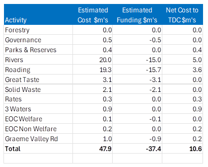
Table 1 –
Summary of Estimated Costs and Funding
1.11 Some
areas have already received full funding, while others will require Council
contribution or internal absorption. Significant funding support is being
pursued through the various central government agencies.
2. Recommendation/s
/ Ngā Tūtohunga
That the Tasman
District Council
1. receives
the June/July 2025 Two Weather Events - Recovery Update report, RCN25-09-14;
and
2. approves
a Council contribution of 9.5% of total costs, up to a maximum of $100,000,
towards the reinstatement of Graham Valley South Branch Road, to be funded from
the subsidised roading activity; and
3. notes that as at 2 September 2025, the Council could
be looking to fund around $10.6 million to recover from all the damage incurred
by the two weather events.
3. The
Recovery Structure
3.1 In
the Civil Defence Emergency Management context, two Group Recovery Managers and
a Recovery Support Manager oversee the recovery process.
3.2 Recovery
is delivered through five key work streams called pou: iwi, natural, built,
social and economic (see Figure 1).
3.3 Each
pou has a lead who coordinates activities and reports to the Recovery Support
Manager and Recovery Managers. Support functions for the pou include community
engagement and communications, and finance and funding.
3.4 These
roles interact to create a framework for a strength-based, holistic and
inclusive approach to recovery.
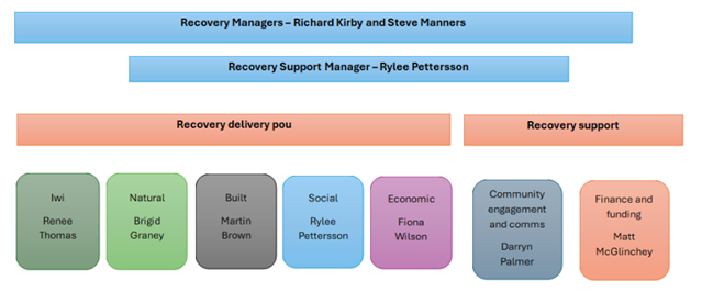 Figure 1: June/July floods recovery structure
Iwi
3.5 Iwi
have been consulted during the recovery process and have provided advice on
planned waste management activities near sites of archaeological significance
(Riwaka) and burial sites (near the Motueka Wastewater Treatment Plant).
3.6 Rāhui processes are being
reviewed and are awaiting sign-off from iwi partners. It is important to note
that the setting of rāhui is generally undertaken in response, while the
lifting often occurs during recovery.
Social impact
3.7 Effective
social recovery is critical to the overall recovery of a community. As such,
the Council has contracted three recovery navigators to engage with people who
have been impacted by these events.
3.8 Navigators
aim to facilitate access to the right support at the right time to affected
individuals and family/whānau to enable them to move forward with their
lives.
3.9 The
navigators have organised several community outreach events and partnered with
organisations such as Nelson Bays Primary Health and the Rural Support Trust to
attend these events. They are aware of the stress caused by dealing with
insurance companies and the subsequent impact on psychosocial wellbeing, so
have referred some people to New Zealand Claims Resolution Service to assist
with the insurance claims process.
Economic impact to Tasman
3.10 A
Tasman Key Sector Impacts Report was commissioned by the Nelson Regional
Development Agency (NRDA). The report is based on information collected from
the key primary industry and tourism sectors up to the second week of August
2025 and provides a high-level, indicative summary of the economic impacts.
3.11 Key
findings show that the cumulative effects over the long-term will be more than
$260 million, with almost $50 million of potential lost GDP from lower
production and demand in the next year alone, split as follows:
· $25m forestry
losses (14% of baseline forestry GDP)
· $11m horticulture
and viticulture losses (4% of baseline horticulture and viticulture GDP)
· $6m livestock
losses (4% of baseline livestock GDP)
· $6m tourism losses
(3% of baseline tourism GDP)
· $0.4m
aquaculture losses (0.2% of baseline seafood and aquaculture GDP
4.1 Extensive
damage has been experienced in our river network. In our larger rivers (XY
rivers), the Motueka, Motupiko, Tadmor and Wai-iti rivers have been worst
affected. Numerous smaller river Z rivers have also been impacted.
4.2 Urgent
works are currently being undertaken in several locations to stabilise
riverbanks and bridge abutments. The immediate focus is on quantifying the
impairment of insured assets.
4.3 The
Rivers team have begun a comprehensive review of our XY river network using a
longer-term, risk-based approach to determine the best way to recover, with a
focus on future resilience.
4.4 This
review will help to inform costs to both the Council and funders on the level
of support required.
4.5 Costs
to Council: The impact on river infrastructure (i.e. insured assets) is
provisionally estimated as at least $20 million. Access to several affected
sites is still restricted, which limits the ability to confirm the full extent
of the damage. The first invoices for river-related repairs are expected
imminently.
4.6 Complete
recovery costs will depend on the full extent of damage, ability to pay, and
the overall recovery strategy.
4.7 Funding is anticipated from three main
sources:
· 60% from National Emergency Management Agency (NEMA) and 40% from
the Council’s insurer, Aon.
· The claim to NEMA and Aon is subject to specific assets registered
on the insurance schedule. This is in the process of assessment. There is an
excess of $750,000 to be covered by the Council. NEMA has their own criteria of
what claims they accept, which may differ to what Aon accept.
4.8 There is also a possibility that funding via the Regional
Infrastructure Fund (RIF) may be accessed. This is
administered through Kānoa (Regional Economic Development and
Investment Unit at the Ministry of Business, Innovation and
Employment (MBIE)). The fund covers 60% of eligible
costs, meaning that the Council would need to co-fund the remaining 40% to
unlock that support.
4.9 At this stage, Kānoa have ringfenced $16 million for tranche
two of the RIF, focusing on ‘build back better’ initiatives to
improve resilience to the Tasman river network.
4.10 Overall, the target is to secure funding for at least 75% of total
river restoration costs through a mix of insurance and government contributions
5.1 The district
roading network suffered widespread damage and a large recovery effort is
underway via the Tasman Alliance. Currently, over 4,000 jobs associated with
the emergency have been entered into the system and at the time of writing
1,900 jobs were still open and requiring work to be completed.
5.2 Management of the roading recovery works
is a significant task and a team has been set up within the Tasman Alliance for
this.
5.3 Costs to the Council: the total
cost of repairs and restoration is currently estimated at
$20-25 million. Approximately $6 million has been spent during July and August.
a. Funding: The Council has secured via the New Zealand Transport
Agency’s (NZTA) Emergency Works fund, an increase in our Funding
Assistance Rate (FAR) to 91% for response activities, and 81% for recovery
activities. Additionally, the Ministry for the Environment (MfE) may contribute
toward the cost of silt removal on roads.
5.4 A significant
under slip has led to the sustained closure of Graham Valley South Branch Road,
isolating one household and preventing vehicle access to the Flora car park in
the Kahurangi National Park.
5.5 Graham Valley South Branch Road is part
of the roading network, but financial responsibility for maintenance sits with
the Department of Conservation (DoC). The Council has been working with DoC and
NZTA regarding funding. NZTA has decided to provide funding assistance to DoC
of 71% for the estimated $1million reinstatement cost. DoC has requested that
the Council contribute 50/50 towards the remaining 29%, or approximately
$150,000.
5.6 Staff have suggested to NZTA that the
reinstatement could be funded via the Council at our 81% funding assistance
rate, however NZTA have decided to fund DoC. The Council would have expected to
do a 50/50 cost share with DoC for the remaining 19%. On this basis, a valid
offer from the Council would be to fund 9.5% or up to approximately $100,000 of
the reinstatement costs.
Three Waters
6.1 The damage
sustained to the three waters infrastructure was not extensive, and the three
water activities are now back to business-as-usual. A
recovery plan has been written to address the long-term resilience of the
network.
6.2 Cost to Council: time to repair,
clean-up costs and damage to three waters infrastructure (water supply,
wastewater, and stormwater) is estimated at $800,000. Forty percent (40%) of
the damage can be claimed through the Aon Infrastructure policy for assets
registered in the asset schedule. Rivers and Waters and Waste access a common
deductible of $750,000 per event. The 60% funding provision by NEMA is not
accessible due to the cost of damage not exceeding the applicable threshold of
$2.1 million. The NEMA threshold for three waters is at a higher rate than
rivers and the Council will need to meet the 60% shortfall through internal
funding.
Waste management
6.3 There were extensive amounts of silt and
complex debris including woody vegetation, plastics and fencing materials
deposited in rivers, the roading network, the marine environment, and on both
private and public land.
6.4 The Council provided access for domestic
waste to be dumped at the Council’s cost at resource recovery centres,
until 10 August 2025. After demand reduced, requests are now being managed on a
case-by-case basis.
6.5 The
majority of horticultural and agricultural waste disposal has been organised by
growers who have worked with neighbouring properties to make arrangements. The
Council has assisted a small number of growers in Riwaka to receive silt at the
carpark of the Riwaka Rugby Grounds and is managing disposal of this material.
6.6 Arrangements
have been made with a nearby landowner in Riwaka to dispose of the silt on
their land. A site of archaeological significance is present on the land and
Council staff have been consulting with iwi to ensure that there are no
concerns with laying silt near this site.
6.7 On
the site there will be some disturbance of the silt that has been deposited on
top of the existing ground, but there will be no digging into the existing
ground. The land is cultivated at present and in future the silt that is
spread will be ploughed and mixed with the existing ground. Iwi have agreed
with this in principle, provided that the silt is tested (completed) and there
is no significant ground disturbance.
6.8 Cost to Council and funding: The
waste management activity is forecast to incur costs of $2.67 million in
response to flood-related waste and disposal challenges.
6.9 The Ministry for the Environment have
agreed to fund a 70% subsidy up to $2 million via the Emergency Waste Fund, and
the Council will need to contribute $670,000 to unlock this funding. The funding has extended to include the management and disposal of
horticultural and agricultural silt, complex waste in the river network and the
marine environment.
6.10 The Council’s contribution of
approximately $670,000 will be funded through existing activity and capital
budgets, including waste levy funds, and the Nelson Tasman Landfill Business
Unit (NTRLBU) contingency fund, created following the August 2022 event. Any
shortfall in funding will be covered by activity reserves. Discussions are
ongoing to confirm access to NTRLBU funds, and further analysis of detailed
expenditure will be required to finalise the funding strategy.
7. Tasman’s
Great Taste Trail
7.1 Tasman’s
Great Taste Trail suffered significant damage, with total repair and
reconstruction costs estimated at $3.1 million. This will be managed in two
tranches.
7.2 The first
tranche, valued at $1.6 million, which includes all affected trail sections except
for Wakefield-Belgrove, is awaiting an announcement from MBIE via the NZ
Cycle Trail Fund Extreme Event Funding.
7.3 The second
tranche, which includes a new trail between Wakefield and Belgrove, is still in
the planning stages and a funding decision from MBIE may be expected after our
route planning has been completed later this year.
8. Council Parks and Forestry
Parks
8.1 Council
parks and open spaces have experienced damage costing an estimated $500,000.
Unfortunately, this figure falls below the insurance excess, and no other
external funding sources are currently available. As a result, the Council will
need to absorb this cost internally, likely either through current operating
budgets or by incorporating it into future rate increases from the 2026/27
financial year onwards.
Forestry
8.2 While
forestry operations were impacted by the emergency, the financial effect in the
immediate term is expected to be neutral. The Council anticipates approximately
$2 million in increased revenue in the 2025/26 year due to early harvesting,
which will offset expected revenue reductions in 2026/27.
8.3 However,
there will be longer-term impacts, as trees scheduled for harvest in 2027/28
and beyond have been brought forward, potentially reducing future income in
those years.
9. Funding
– Mayoral Relief Fund
9.1 The
Mayoral Relief Fund (MRF) was established to support those directly impacted by
the weather events. Total contributions to date are $475,000 including $150,000
in direct Government support. To date, $316,000 has been paid out to 140
claimants.
9.2 The
Ministry of Primary Industry (MPI) has agreed to fund $340,000 for a rural
sector fund, to be administered by the Council. This fund is available to those
who have experienced damage and receive more than 51% of their income from
their property.
9.3 Both
funds closed on 5 September 2025. The panel for the MRF meets and distributes
funds weekly with a washup of any remaining funds planned shortly after the
closing date. The panel for the rural sector fund will endeavour to meet within
a couple of weeks of the fund closing to assess all applications.
10. External
Expertise and Resources
10.1 In
response to the scale and complexity of the emergency event, the Council
engaged approximately ten external personnel across a range of specialist
roles. These resources were brought in to supplement internal capacity and
ensure an effective, coordinated recovery effort across multiple workstreams.
10.2 Among
these roles, a number of specialists were appointed to assist with asset
condition assessments. This was critical in identifying the extent of damage
across infrastructure, facilities, and public amenities, and in prioritising
repair works. Given that many sites were initially inaccessible, specialist
assessments were staged over several weeks as access was restored.
10.3 Funding
coordination has also required dedicated expertise. The Council appointed
individuals specifically to manage funding applications, liaise with central
government agencies (such as NEMA, NZTA, MFE, and MBIE), and ensure compliance
with eligibility criteria. These roles are essential for securing the maximum
possible external contribution toward recovery costs, and for managing the
significant reporting requirements associated with such funding.
10.4 Recovery
Navigators were engaged to work directly with affected residents, landowners,
and community groups, particularly in areas where impacts were most severe.
These roles focused on community engagement, needs assessment, and coordination
of relief assistance and rebuilding efforts, ensuring that recovery plans
remained responsive to those most affected.
10.5 A
GIS (Geographic Information System) specialist was also brought in to support
spatial mapping of damage zones, assist with risk analysis, and help visualise
the extent of flooding and infrastructure impacts. This data was critical for
informing decision-making and communicating recovery progress to internal
stakeholders and the public.
10.6 In
addition, data capture specialists were contracted to help record and
consolidate operational, financial, and asset-related information from across
the organisation and the field. Their work underpins both reporting obligations
and future mitigation planning.
10.7 Given the significant cost associated with
these external resources, estimated at over $415,000, the Council is actively
seeking reimbursement or co-funding from central government. These
applications are currently in progress, and confirmation of eligible funding
streams is expected to occur over the coming months
11. Additional
costs to Council
11.1 Emergency Operations Centre (EOC): The EOC incurred costs
totalling approximately $265,000. Of this, $105,000 relates to welfare
operations, which are expected to be fully funded through NEMA.
11.2 The
remaining $160,000 is yet to be formally allocated and may ultimately be split
between joint operations (shared across councils) and Council responsibilities.
An internal process is still underway to determine the appropriate allocation
and final funding responsibilities for this remaining portion.
11.3 Staff time:
The data reveals that the organisation dedicated a substantial amount of
peoplepower to managing emergency and weather-related events, totalling over
10,400 hours between the 2024/25 and 2025/26 fiscal years. Nearly 86% of these
hours were concentrated in 2025/26, indicating that the response and recovery
efforts will extend well beyond the initial impact.
11.4 At
an hourly rate of $50, this labour effort translates to over $530,000 in costs,
representing a significant financial burden on top of other emergency-related
expenditures. The sustained high level of staff involvement suggests that the
organisation has had to divert considerable resources away from its regular
business-as-usual activities. This diversion has likely caused delays or
interruptions in routine projects and services; it has impacted overall service
delivery and operational efficiency.
11.5 While these costs and challenges highlight
the immediate and ongoing strain emergency events impose, the experience and
coordination developed during this time could enhance the organisation’s
future preparedness and resilience. Nonetheless, the findings emphasise the
need for careful resource planning to ensure emergency responses do not unduly
compromise everyday operations.
12. Rating
– Financial Impacts
12.1 As
a result of damage to properties, approximately 300-400 properties need to be
revalued by Quotable Value. The costs are $150,000 for this work. Once the
valuations are complete, the Council will also lose the rate revenue associated
with rates calculated on the property value, General Rate being the largest.
This is estimated at a further $150,000 cost to the Council. Funding sources
for this are being pursued.
13. Conclusion
/ Kupu Whakatepe
13.1 The Recovery has progressed very well. The
Recovery Team have collaborated with the various agencies and targeted support
as required.
13.2 The overall cost to council of the two events is
estimated to be around $10.6 million.
14. Next
Steps and Timeline / Ngā Mahi Whai Ake
14.1 To progress with the Recovery effort. The future efforts will
be in three specific areas;
· firstly
the Navigators working in the various agencies and directing affected people
accordingly, and
· secondly
focusing on restoring the road network including appropriate resilience in
specific areas, and
· thirdly
working in the rivers to restore appropriate erosion protection.
Nil
7.11 Recommendation from the Nelson Tasman Regional Landfill Business
Unit - Annual Report 2024/2025
|
Report
To:
|
Tasman
District Council
|
|
Meeting
Date:
|
11
September 2025
|
|
Report
Author:
|
David
Stephenson, Team Leader - Stormwater & Waste Management
|
|
Report
Authorisers:
|
Richard
Kirby, Group Manager - Community Infrastructure
|
|
Report
Number:
|
RCN25-09-15
|
1. Purpose
of the Report / Te Take mō te Pūrongo
1.1 To consider a recommendation
from the Nelson Tasman Regional Landfill Business Unit following the meeting
held on Wednesday 27 August 2025.
2. Summary
/ Te Tuhinga Whakarāpoto
2.1 At the 27 August 2025 meeting,
the Nelson Tasman Regional Landfill Business Unit following the meeting
resolved as follows:
That the Nelson Tasman Regional
Landfill Business Unit
1. Approves
the Nelson Tasman Regional Landfill Business Unit Annual Report 2024/2025
and the Nelson Tasman Regional Landfill Business Unit Annual Financial Statements
2024/2025 for presentation to Nelson City Council and Tasman District Council
with Delegation of all minor amendments to the Nelson Tasman Regional Landfill
Business Unit General Manager.
2.2 Link
to the agenda and recording for the 27 August 2025 Nelson Tasman
Regional Landfill Business Unit meeting.
3. Recommendation/s
/ Ngā Tūtohunga
That the Tasman
District Council
1. receives
the Recommendation from the Nelson Tasman Regional Landfill Business Unit -
Annual Report 2024/2025 RCN25-09-15; and
2. receives the Nelson Tasman Regional Landfill Business
Unit Annual Report 2024/2025 and its attachment to the agenda report, the
Nelson Tasman Regional Landfill Business Unit – Financial Statements
2024/2025.
Nil
7.12 Recommendation from the Nelson Tasman Regionsl Landfill Business
Unit - Class 3 Contaminated Soil Graduated Fee Update
|
Report
To:
|
Tasman
District Council
|
|
Meeting
Date:
|
11
September 2025
|
|
Report
Author:
|
David
Stephenson, Team Leader - Stormwater & Waste Management
|
|
Report
Authorisers:
|
Richard
Kirby, Group Manager - Community Infrastructure
|
|
Report
Number:
|
RCN25-09-16
|
1. Purpose
of the Report / Te Take mō te Pūrongo
1.1 To
consider a recommendation from the Nelson Tasman Regional Landfill Business
Unit following the meeting held on Wednesday 27 August 2025.
2. Summary
/ Te Tuhinga Whakarāpoto
2.1 At
the 27 August 2025 meeting the Nelson Tasman Regional Landfill Business Unit
following the meeting resolved as follows:
That the Nelson Tasman Regional
Landfill Business Unit
1. supports
the reduced fee proposal as detailed in Report R25-409 for disposal of class 3
contaminated soils at Eves Valley Landfills; and
2. notes
the consultation undertaken; and
3. approves
that the proposal for reduced fees at Eves Valley Landfill be submitted to the two
Councils for approval; and
4. notes
that subject to approval from both Councils, that these changes will take
effect from 1 October 2025
2.2 Link
to the agenda and recording for the 27 August 2025 Nelson Tasman
Regional Landfill Business Unit meeting.
3. Recommendation/s
/ Ngā Tūtohunga
That the Tasman
District Council
1. receives
the Recommendation from the Nelson Tasman Regionsl Landfill Business Unit -
Class 3 Contaminated Soil Graduated Fee Update RCN25-09-16; and
2. approves the reduced fee structure as detailed in
Report R25-409 noted in the agenda report for disposal of class 3 contaminated
soils at Eves Valley Landfill.
Nil
7.13 Recommendation from the Nelson Tasman Regional Landfill Business
Unit - Draft Business Plan 2026/2027
|
Report
To:
|
Tasman
District Council
|
|
Meeting
Date:
|
11
September 2025
|
|
Report
Author:
|
David
Stephenson, Team Leader - Stormwater & Waste Management
|
|
Report
Authorisers:
|
Richard
Kirby, Group Manager - Community Infrastructure
|
|
Report
Number:
|
RCN25-09-17
|
1. Purpose
of the Report / Te Take mō te Pūrongo
1.1 To
consider a recommendation from the Nelson Tasman Regional Landfill Business
Unit following the meeting held on Wednesday 27 August 2025.
2. Summary
/ Te Tuhinga Whakarāpoto
2.1 At
the 27 August 2025 meeting the Nelson Tasman Regional Landfill Business Unit
following the meeting resolved as follows:
That the Nelson Tasman Regional
Landfill Business Unit
1. Approves
the Nelson Tasman Regional Landfill Business Unit Draft Business Plan 2026/27
(NDOCS-749984575-2074) for presentation to the Nelson City Council and Tasman
District Council for review and feedback, with delegation of all minor
amendments to the Nelson Tasman Regional Landfill Business Unit Chairperson and
General Manager.
2.2 Link to the agenda
and
recording for the 27 August 2025 Nelson Tasman Regional Landfill Business
Unit meeting.
2.3 Included
in the Draft Business Plan 2026/27 is a proposal to increase the charge for
General Refuse from $266 per tonne (excluding GST) in 2025/26 to $311 per tonne
in 2026/27, an increase of $45 per tonne, or 17%.
2.4 The
report to the Nelson Tasman Regional Landfill Business Unit indicates that 62%
of the increase in gate charges is due a proposed increase in the Local
Disposal Levy, which moves from $3m to each council in 2025/26 to $3.9m in
2026/27.
2.5 The
Local Disposal Levy is a payment made to the Councils to fund waste management
and minimisation activities. Each year the councils make requests to the Nelson
Tasman Regional Landfill Business Unit, and normally the lower of the two bids
is included in the business plan. For Tasman District Council, the Local
Disposal Levy is used to offset the fixed cost of operating resource recovery
centres and other waste facilities.
2.6 As
discussed in the report to the Council for deliberations on fees and charges on
27 May 2025, our resource recovery centres fixed costs total approximately $4m,
and our current Local Disposal Levy is $3m, leaving $1m to be funded through
fees and charges, or general rate if gate revenue is insufficient.
2.7 For
this reason, our request to the business unit this year was for a Local
Disposal Levy of $4m, which would eliminate the need for fees and charges or
general rates to fund our fixed operating costs.
2.8 While
the proposed business plan provides a Local Disposal Levy of $3.9m, rather than
$4m, our initial analysis indicates that resource recovery centre charges would
decrease by approximately 3% - from $360 per tonne (excluding GST) to
approximately $350 per tonne.
3. Recommendation/s
/ Ngā Tūtohunga
That the Tasman
District Council
1. receives
the Recommendation from the Nelson Tasman Regional Landfill Business Unit -
Draft Business Plan 2026/2027 RCN25-09-17; and
2. receives
the Nelson Tasman Regional Landfill Business Unit Draft Business Plan 2026/27
(NDOCS-749984575-2074) for review and feedback to the Nelson Tasman Regional
Landfill Business Unit; and
3. notes
that staff will review and provide feedback to Council on the Draft Business
Plan 2026/27 (NDOCS-749984575-2074) prior to responding to the Nelson Tasman
Regional Landfill Business Unit.
Nil
7.14 Chief Executive Officer Update
Information Only - No Decision
Required
|
Report
To:
|
Tasman
District Council
|
|
Meeting
Date:
|
11
September 2025
|
|
Report
Author:
|
Leonie
Rae, Chief Executive Officer
|
|
Report
Number:
|
RCN25-09-18
|
1. Summary
/ Te Tuhinga Whakarāpoto
1.1 The purpose of
this report is to provide an update since the Chief Executive’s last
report on 31 July 2025.
2. Recommendation/s
/ Ngā Tūtohunga
That the Tasman District Council
1. receives the Chief Executive Officer Update report, RCN25-09-18.
3. Severe
Weather Events - Recovery
3.1 At the time of
writing, Tasman District Council is still in the recovery phase after the
severe weather events and States of Emergency in June and July 2025.
3.2 There is still a
lot of recovery work being undertaken and although we hope to transition out of
recovery on 11 September 2025, there is a large amount of damage throughout the
region that will take a very long time to repair.
3.3 More information
relating to the recovery phase will be reported on through the Operations
Committee.
4. Acting Chief Executive
4.1 I am on annual
leave from Friday 12 September 2025, returning on Monday 6 October 2025.
4.2 Steve Manners
will undertake the role of Acting Chief Executive during that time. Joanna
Cranness will undertake the role of Acting Chief Operating Officer during that
time.
5. Opportunity to Acknowledge Elected Members
5.1 As I will be on
annual leave at the time of the last Full Council meeting for this triennium, I
would like to take this opportunity to thank you all for your valuable
contributions to Tasman District Council this triennium.
5.2 To those elected
members not standing again, thank you and farewell.
5.3 To those elected
members who have stood again, I wish you every success during the election and
look forward to seeing you again in the new triennium.
5.4 I took the
opportunity to attend the Motueka and Tākaka Community Board meetings in
August, to express my appreciation of their valuable contributions too, as I
will be on leave for their last meetings of the triennium.
6. Local Government Elections 2025 Update
6.1 Nominations
closed at 12 noon on Friday 1 August 2025, with 40 candidates standing for 23
positions. There are five candidates for the Mayoralty. Candidate details are
on the Council’s website. There will be no election for the Te Tai o
Aorere Māori Ward, as there was one nomination for the position, with Paul
Te Poa Karoro Morgan elected unopposed, all other positions are contested.
6.2 The
voting period will run from 9 September on Saturday 11 October 2025 with
progressive results expected Saturday afternoon. Preliminary results are
expected on Sunday 12 October 2025, with official results expected by 17
October 2025.
6.3 Voting
papers and candidate booklets are currently being printed and deliveries will
commence on 9 September 2025. There will be special voting facilities (for
those that have not received a voting paper) and ballot boxes in the service
centres and ballot boxes in the libraries.
6.4 The
Richmond Service Centre will be open on Saturday 11 October 2025 for people to
cast a special vote or post their voting papers. Voting papers posted at the
outlying service centres and libraries on Saturday morning will be collected
from 12 noon on Saturday 11 October 2025 to be delivered to our electoral
providers.
7. Organisation Change Proposal Update
7.1 I
recently initiated an organisation-wide change process regarding proposed
changes to the structure of the Executive Leadership Team and Senior Leadership
Group and their supporting activities. The focus of change is on:
· Reshaping leadership roles to put strategy and outcomes at the core
· Align the strategy and finance activities together
· Position the Council to lead and influence the Local Water Done Well
programme
· Bring together those services our customers and community are
passionate about – and improve the customer experience.
7.2 The
four-week consultation period for staff ended on 25 August 2025, and at the
time of writing this report, I am speaking with staff whose roles are most
affected and advising all staff of the final outcome on 3 September 2025.
7.3 There
are still a few steps to go before the changes are finalised and implemented,
however it is expected these changes will take effect throughout the month of
November 2025.
Nil
8 CONFIDENTIAL SESSION
8.1 Procedural
motion to exclude the public
The following
motion is submitted for consideration:
That the
public be excluded from the following part(s) of the proceedings of this
meeting. The general subject of each matter to be considered while the public
is excluded, the reason for passing this resolution in relation to each matter,
and the specific grounds under section 48(1) of the Local Government Official
Information and Meetings Act 1987 for the passing of this resolution follows.
This resolution is made in reliance on section 48(1)(a) of the Local
Government Official Information and Meetings Act 1987 and the particular
interest or interests protected by section 6 or section 7 of that Act which
would be prejudiced by the holding of the whole or relevant part of the
proceedings of the meeting in public, as follows:
8.2 Richmond Aquatic Centre - Procurement of
Management and Operations Agreement Report
|
Reason for passing this resolution in
relation to each matter
|
Particular interest(s) protected (where
applicable)
|
Ground(s) under section 48(1) for the
passing of this resolution
|
|
The public conduct of the part of the
meeting would be likely to result in the disclosure of information for which
good reason for withholding exists under section 7.
|
s7(2)(h) - The withholding of the
information is necessary to enable the local authority to carry out, without
prejudice or disadvantage, commercial activities.
|
s48(1)(a)
The public conduct of the part of the
meeting would be likely to result in the disclosure of information for which
good reason for withholding exists under section 7.
|
8.3 Motueka Property Update - Former Motueka
Library Building, Laura Ingram Building, Motueka Service Centre and Hickmott
Place Carpark
|
Reason for passing this resolution in
relation to each matter
|
Particular interest(s) protected (where
applicable)
|
Ground(s) under section 48(1) for the
passing of this resolution
|
|
The public conduct of the part of the
meeting would be likely to result in the disclosure of information for which
good reason for withholding exists under section 7.
|
s7(2)(h) - The withholding of the
information is necessary to enable the local authority to carry out, without
prejudice or disadvantage, commercial activities.
|
s48(1)(a)
The public conduct of the part of the
meeting would be likely to result in the disclosure of information for which
good reason for withholding exists under section 7.
|
8.4 Review of Property Holding - Motueka
|
Reason for passing this resolution in
relation to each matter
|
Particular interest(s) protected (where
applicable)
|
Ground(s) under section 48(1) for the
passing of this resolution
|
|
The public conduct of the part of the
meeting would be likely to result in the disclosure of information for which
good reason for withholding exists under section 7.
|
s7(2)(h) - The withholding of the
information is necessary to enable the local authority to carry out, without
prejudice or disadvantage, commercial activities.
s7(2)(i) - The withholding of the
information is necessary to enable the local authority to carry on, without
prejudice or disadvantage, negotiations (including commercial and industrial
negotiations).
|
s48(1)(a)
The public conduct of the part of the
meeting would be likely to result in the disclosure of information for which
good reason for withholding exists under section 7.
|
8.5 Motueka Community Pool Project Update
|
Reason for passing this resolution in
relation to each matter
|
Particular interest(s) protected (where
applicable)
|
Ground(s) under section 48(1) for the
passing of this resolution
|
|
The public conduct of the part of the
meeting would be likely to result in the disclosure of information for which
good reason for withholding exists under section 7.
|
s7(2)(c)(ii) - The withholding of the
information is necessary to protect information which is subject to an
obligation of confidence or which any person has been or could be compelled
to provide under the authority of any enactment, where the making available
of the information would be likely to damage the public interest.
For Council to Act a Guarantor for and
agreed amount of Community funding to allow work to continue is likelyto
reduce onus and committment by the comunity to rasie required funding.
s7(2)(h) - The withholding of the
information is necessary to enable the local authority to carry out, without
prejudice or disadvantage, commercial activities.
For Council to Act a Guarantor for and
agreed amount of Community funding to allow work to continue is likelyto
reduce onus and committment by the comunity to rasie required funding.
s7(2)(i) - The withholding of the
information is necessary to enable the local authority to carry on, without
prejudice or disadvantage, negotiations (including commercial and industrial
negotiations).
For Council to Act a Guarantor for and
agreed amount of Community funding to allow work to continue is likelyto
reduce onus and committment by the comunity to rasie required funding.
s7(2)(j) - The withholding of the
information is necessary to prevent the disclosure or use of official
information for improper gain or improper advantage.
For Council to Act a Guarantor for and
agreed amount of Community funding to allow work to continue is likelyto
reduce onus and committment by the comunity to rasie required funding.
|
s48(1)(a)
The public conduct of the part of the
meeting would be likely to result in the disclosure of information for which
good reason for withholding exists under section 7.
|
8.6 Chief Executive Officer Remuneration Review
2025/26
|
Reason for passing this resolution in
relation to each matter
|
Particular interest(s) protected (where
applicable)
|
Ground(s) under section 48(1) for the
passing of this resolution
|
|
The public conduct of the part of the
meeting would be likely to result in the disclosure of information for which
good reason for withholding exists under section 7.
|
s7(2)(a) - The withholding of the
information is necessary to protect the privacy of natural persons, including
that of a deceased person.
|
s48(1)(a)
The public conduct of the part of the
meeting would be likely to result in the disclosure of information for which
good reason for withholding exists under section 7.
|