Notice
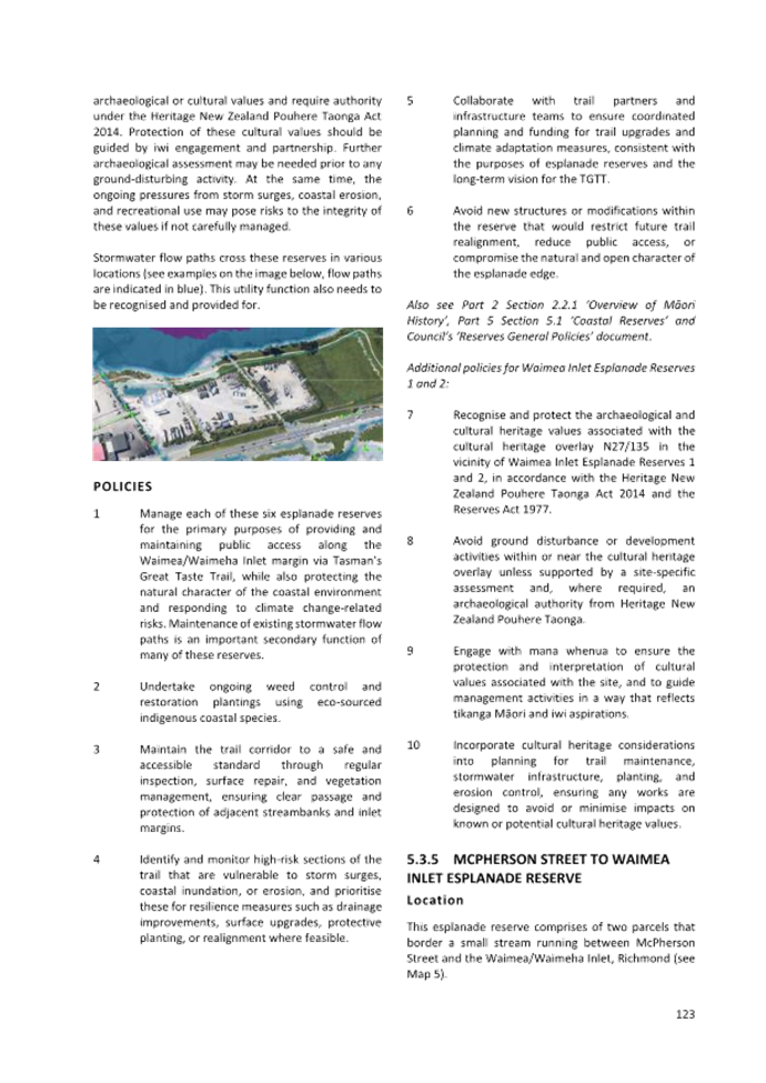
is given that an ordinary meeting of the Tasman District Council will be held
on:
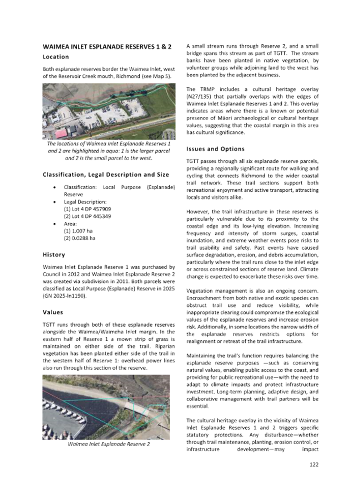
|
Date:
Time:
Meeting
Room:
Venue:
Zoom
conference link:
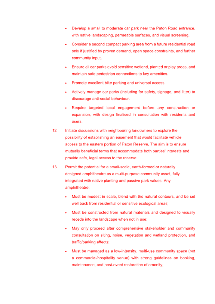
Meeting ID:
Meeting Passcode:
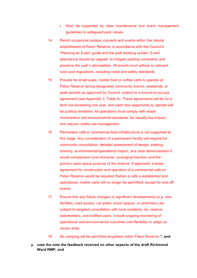
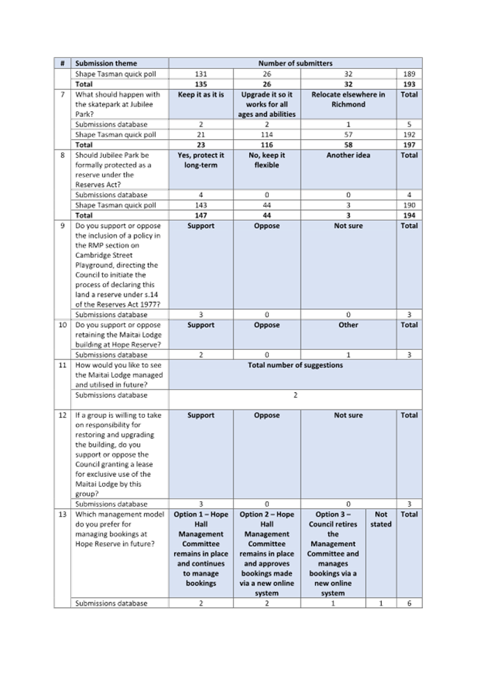
|
Thursday 14 August 2025
9.30 am
Tasman Council Chamber
189 Queen Street, Richmond
https://us02web.zoom.us/j/88161083801?
881 6108 3801
304437
|
|
Tasman
District Council
Kaunihera
Katoa
AGENDA
|
MEMBERSHIP
|
Mayor
|
Mayor T King
|
|
|
Deputy Mayor
|
Deputy Mayor S Bryant
|
|
|
Councillors
|
Councillor C Butler
|
Councillor M Kininmonth
|
|
|
Councillor G Daikee
|
Councillor C Mackenzie
|
|
|
Councillor B Dowler
|
Councillor K Maling
|
|
|
Councillor J Ellis
|
Councillor B Maru
|
|
|
Councillor M Greening
|
Councillor D Shallcrass
|
|
|
Councillor C Hill
|
Councillor T Walker
|
(Quorum 7 members)
|
|
|
Contact Telephone: 03 543 8400
Email: Robyn.Scherer@tasman.govt.nz
Website: www.tasman.govt.nz
|
Tasman District
Council
Agenda – 14 August 2025
AGENDA
1 Opening, Welcome, KARAKIA
2 Apologies
and Leave of Absence
|
Recommendation
That apologies be accepted.
|
3 Public
Forum
Nil
4 Declarations
of Interest
5 LATE
ITEMS
6 Confirmation
of MINUTES
Nil
7 Reports
7.1 Adoption of the Nelson-Tasman Mayoral
Relief Fund Policy................................. 4
7.2 Adoption of the Lakes-Murchison Ward
Reserve Management Plan
and RMP section on Baigents Bush Scenic Reserve, Pigeon Valley................... 12
7.3 Adoption of the Richmond Ward Reserve
Management Plan............................ 171
7.4 Phase Two - Speed Management Decision........................................................ 444
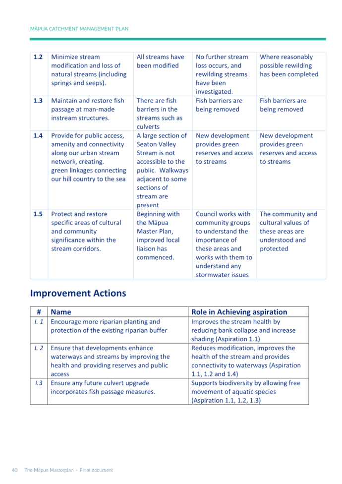
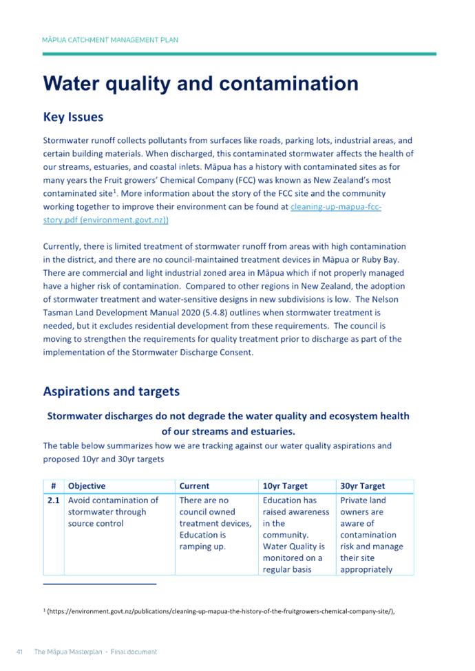
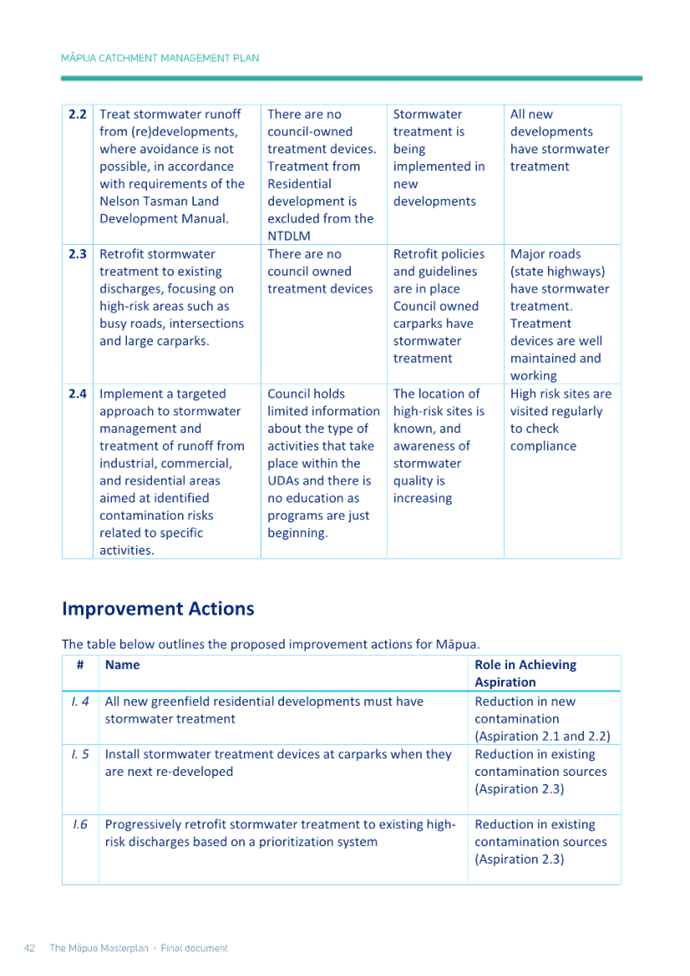
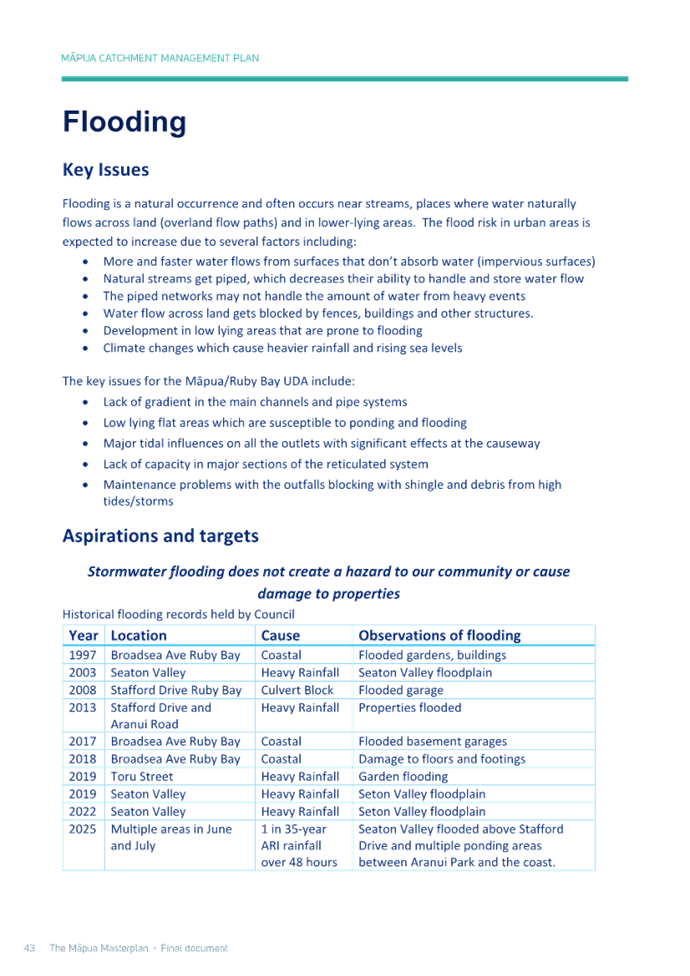
7.5 Māpua Masterplan............................................................................................... 699
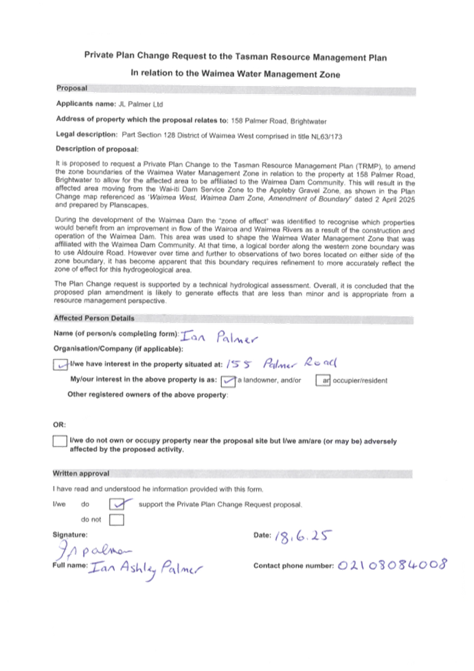
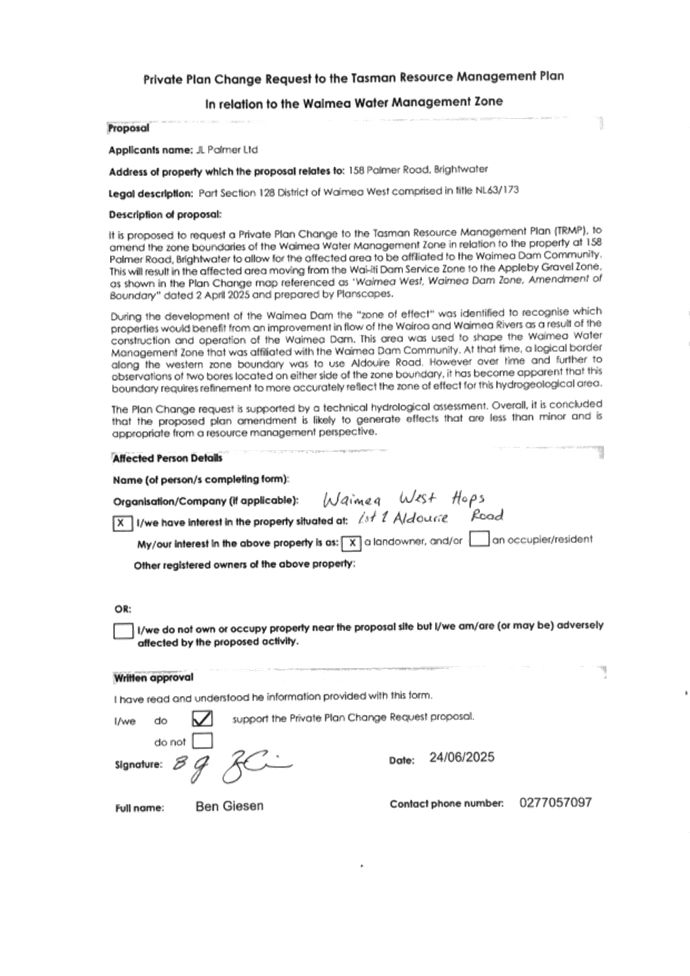
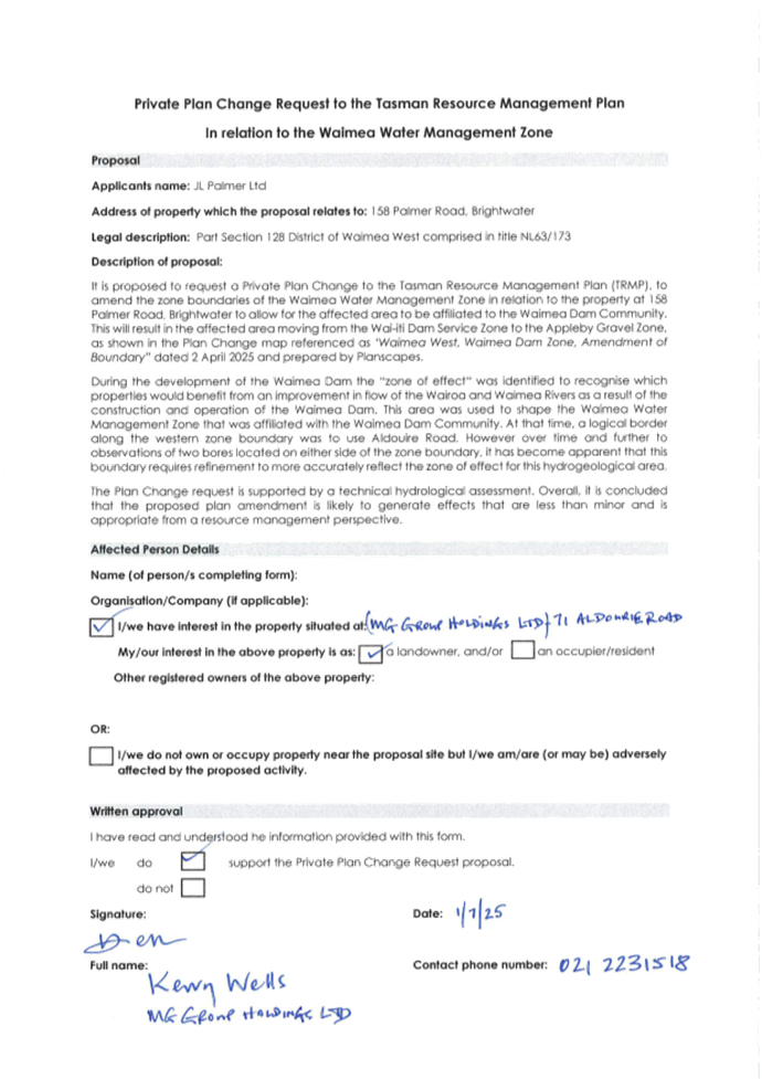
7.6 Private Plan Change Request - JL Palmer
Limited............................................. 754
8 Confidential
Session
Nil
9 CLOSING
KARAKIA
Tasman District
Council
Agenda – 14 August 2025
7 Reports
7.1
Adoption of the
Nelson-Tasman Mayoral Relief Fund Policy
Decision Required
|
Report
To:
|
Tasman
District Council
|
|
Meeting
Date:
|
14
August 2025
|
|
Report
Author:
|
Robyn
Scherer, Executive Assistant and Advisor to the Mayor
|
|
Report
Authorisers:
|
Leonie
Rae, Chief Executive Officer
|
|
Report
Number:
|
RCN25-08-1
|
1. Purpose
of the Report / Te Take mō te Pūrongo
1.1 To
adopt the joint Nelson-Tasman Mayoral Relief Fund Policy.
2. Summary
/ Te Tuhinga Whakarāpoto
2.1 During
the 2022 flood event in Nelson City, Council staff prepared a draft
Nelson-Tasman Mayoral Relief Fund Policy to guide the management and
distribution of funds from the Mayoral Relief Fund Panel upon the event of an
emergency.
2.2 The
draft policy was not ratified by the two councils at that time.
2.3 This
report asks the Council to ratify the draft policy (Attachment 1).
2.4 The
draft policy was ratified by Nelson City Council at its meeting on 7 August
2025.
3. Recommendation/s
/ Ngā Tūtohunga
That the Tasman District Council
1. receives
the Adoption of the Nelson-Tasman Mayoral Relief Fund Policy report,
RCN25-08-1; and
2. notes
that Nelson City Council adopted the Nelson-Tasman Mayoral Relief Fund Policy
at its 7 August 2025 meeting; and
3. adopts the Nelson-Tasman Mayoral Relief Fund Policy in
Attachment 1 to the agenda report.
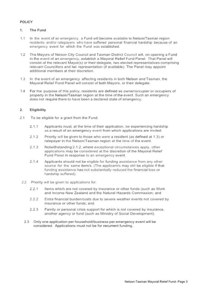
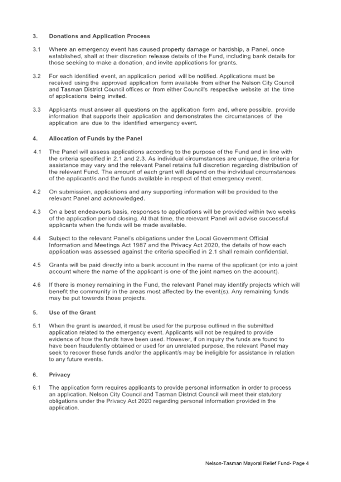
4.1 In
the wake of an emergency event, a Fund will be established to accept monetary
donations from people and organisations who wish to offer financial support for
those affected by the event.
4.2 Such
a Fund will be opened by joint agreement of the Mayors of Nelson City Council
and Tasman District Council, to assist the Nelson-Tasman region residents or
ratepayers adversely affected by an emergency event.
4.3 Once
established, the relevant Fund will offer a hardship grant to affected
residents or ratepayers for property damage or hardship incurred as a result of
an emergency event, including severe or adverse weather events.
4.4 It
is intended that these grants go some way towards helping to alleviate the
emotional and financial stress experienced by individuals, families, and
businesses, due to an emergency event.
5. Analysis
and Advice / Tātaritanga me ngā tohutohu
5.1 There is no current Nelson-Tasman Relief
Fund policy.
5.2 The proposed policy will enable the
Mayors of Nelson City Council and Tasman District Council to:
5.2.1 Establish a Mayoral Relief Fund following an emergency
event;
5.2.2 Establish a Mayoral Relief Fund panel to consider
applications to the fund;
5.2.2.1 The Panel will consist of the
relevant Mayor(s) or their delegate, two elected representatives comprising
relevant Councillors and iwi representation (if available). The Panel may
appoint additional members at its discretion.
5.2.3 Define the eligibility criteria for the fund;
5.2.4 Notify the Mayoral Relief Fund application period
relating to an emergency event;
5.2.5 Enable the Mayoral Relief Fund panel to assess
applications according to the purpose of the fund and in line with the
eligibility criteria;
5.2.6 Enable the Panel to distribute any remaining funds to
identified projects which will benefit the community in the areas most affected
by the emergency event.
6. Financial
or Budgetary Implications / Ngā Ritenga ā-Pūtea
6.1 This decision does not impact on the
Council’s budgets.
7.1 The options are outlined in the
following table:
|
Option
|
Advantage
|
Disadvantage
|
|
1.
|
Approve the Mayoral Relief Fund Policy.
|
Enables the two councils to open and
manage a Mayoral Relief Fund following an emergency event.
|
None
|
|
2.
|
Not approve the Mayoral Relief Fund
Policy.
|
Nil.
|
Does not provide guidance for the
establishment and operation of a Mayoral Relief Fund following an emergency
event.
|
7.2 Option 1 is recommended.
8.1 Nil
9. Iwi
Engagement / Whakawhitiwhiti ā-Hapori Māori
9.1 Iwi will be invited to nominate a
representative for each Mayoral Relief Fund Panel subject to their
availability.
10. Significance
and Engagement / Hiranga me te Whakawhitiwhiti ā-Hapori Whānui
10.1 This policy is of low significance.
|
|
Issue
|
Level of Significance
|
Explanation of
Assessment
|
|
1.
|
Is there a high level
of public interest, or is decision likely to be controversial?
|
No
|
|
|
2.
|
Are there impacts on
the social, economic, environmental or cultural aspects of well-being of the
community in the present or future?
|
Yes
|
These grants will go
some way towards helping to alleviate the emotional and financial stress
experienced by individuals, families, and businesses, due to an emergency
event.
|
|
3.
|
Is there a
significant impact arising from duration of the effects from the decision?
|
No
|
|
|
4.
|
Does the decision
relate to a strategic asset? (refer Significance and Engagement Policy for
list of strategic assets)
|
No
|
|
|
5.
|
Does the decision
create a substantial change in the level of service provided by Council?
|
No
|
|
|
6.
|
Does the proposal,
activity or decision substantially affect debt, rates or Council finances in
any one year or more of the LTP?
|
No
|
|
|
7.
|
Does the decision
involve the sale of a substantial proportion or controlling interest in a CCO
or CCTO?
|
No
|
|
|
8.
|
Does the proposal or
decision involve entry into a private sector partnership or contract to carry
out the delivery on any Council group of activities?
|
No
|
|
|
9.
|
Does the proposal or
decision involve Council exiting from or entering into a group of
activities?
|
No
|
|
|
10.
|
Does the proposal
require particular consideration of the obligations of Te Mana O Te Wai
(TMOTW) relating to freshwater or particular consideration of current
legislation relating to water supply, wastewater and stormwater
infrastructure and services?
|
No
|
|
11. Communication
/ Whakawhitiwhiti Kōrero
11.1 This is an internal Tasman District Council policy.
Staff involved with Mayoral Relief Fund activities will be advised of the
Mayoral Relief Fund Policy.
12.1 No risks are identified with this policy.
13. Climate
Change Considerations / Whakaaro
Whakaaweawe Āhuarangi
13.1 Not applicable.
14. Alignment
with Policy and Strategic Plans / Te Hangai ki ngā aupapa Here me ngā
Mahere Rautaki Tūraru
14.1 The Mayoral Relief Fund policy will be included in
the Council’s Governance policy register.
15. Conclusion
/ Kupu Whakatepe
15.1 A policy to guide the management of Mayoral Relief
Funds will guide the Mayoral Relief Fund Panel in its distribution of funding
after an emergency event.
16. Next
Steps and Timeline / Ngā Mahi Whai Ake
16.1 If adopted, the Mayoral Relief Fund Policy will be included in the
Tasman District Council’s Governance Policies register.
|
1.⇩
|
Nelson-Tasman
Mayoral Relief Fund Policy
|
8
|
Tasman District
Council
Agenda – 14 August 2025

Tasman District Council Agenda – 14 August 2025
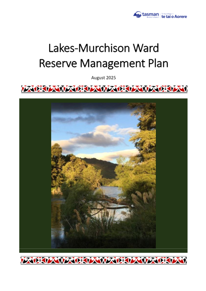
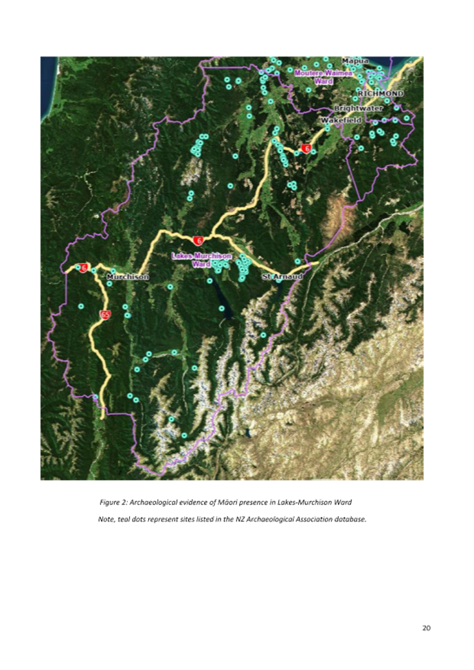
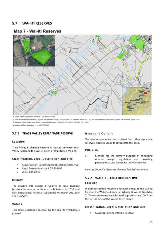
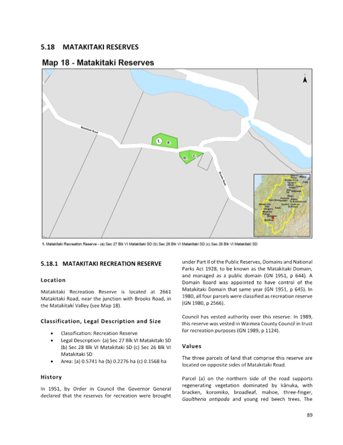
7.2 Adoption of the Lakes-Murchison Ward Reserve Management
Plan and RMP section on Baigents Bush Scenic Reserve, Pigeon Valley
Decision Required
|
Report
To:
|
Tasman
District Council
|
|
Meeting
Date:
|
14
August 2025
|
|
Report
Author:
|
Anna
Gerraty, Senior Community Policy Advisor
|
|
Report
Authorisers:
|
Alan
Bywater, Team Leader - Community Policy; Grant Reburn, Reserves and
Facilities Manager; John Ridd, Group Manager - Service and Strategy
|
|
Report
Number:
|
RCN25-08-2
|
1. Purpose
of the Report / Te Take mō te Pūrongo
1.1 The purpose of this report is
for the Council to:
1.1.1 consider the recommendations of the Hearing Panel
appointed to hear submissions on the Draft Lakes-Murchison Ward Reserve
Management Plan (RMP) and the Draft RMP section on Baigents Bush Scenic
Reserve, Pigeon Valley (see Attachment 1); and
1.1.2 adopt the amended Plan (see Attachment 2) as the
final Lakes-Murchison Ward Reserve Management Plan; and
1.1.3 adopt the amended RMP section on Baigents Bush Scenic
Reserve, Pigeon Valley (see Attachment 3) for inclusion in the
Moutere-Waimea Ward RMP (2022).
2. Summary
/ Te Tuhinga Whakarāpoto
2.1 Both the draft Lakes-Murchison Ward RMP
(Draft Plan) and draft RMP section on Baigents Bush Scenic Reserve (draft RMP
section) were publicly notified on 11 April 2025 and
open for submissions for two months. We received 107 submissions via the
Council’s online submissions database. A further 359 individuals provided
feedback on future options for Owen River Recreation Reserve and another 35
individuals provided feedback on the draft RMP section on Baigents Bush Scenic
Reserve, via a ‘Fast Feedback’ option we provided on Shape Tasman.
The Hearing Panel accepted one late submission at the hearing held on 9 July 2025.
A total of nine submitters spoke to the Panel in support of their submission.
2.2 In general, the submissions received
focused on the key consultation questions proposed in the Draft Plan and draft
RMP section. Other submission points related to climate change, biodiversity,
Māori cultural values, iwi engagement, dark skies, horse riding, and other
general comments.
2.3 Staff have amended the text of both
draft documents as per the Hearing Panel’s recommendations.
3. Recommendation/s
/ Ngā Tūtohunga
That the Tasman District Council
1. receives
the Adoption of the Lakes-Murchison Ward Reserve Management Plan and RMP
section on Baigents Bush Scenic Reserve, Pigeon Valley report, RCN25-08-2; and
2. agrees
to amend the wording of the Lakes-Murchison Ward Reserve Management Plan, as
per the Hearing Panel recommendations included as Attachment 1 to the agenda
report, noting that all amendments have been incorporated into the version
included as Attachment 2 to this report; and
3. agrees
to amend the wording of the Reserve Management Plan section on Baigents Bush
Scenic Reserve, as per the Hearing Panel recommendations included as Attachment
1 to the agenda report, noting that all amendments have been incorporated into
the version included as Attachment 3 to this report; and
4. adopts
the Lakes-Murchison Ward Reserve Management Plan dated August 2025 as contained
in Attachment 2 to the agenda report, in accordance with Section 41 of the
Reserves Act 1977 and delegated authority from the Minister of Conservation
(dated 12 June 2013); and
5. adopts
the Reserve Management Plan section on Baigents Bush Scenic Reserve, Pigeon
Valley as contained in Attachment 3 to the agenda report for inclusion in the
Moutere-Waimea Ward Reserve Management Plan (2022), in accordance with Section
41 of the Reserves Act 1977 and delegated authority from the Minister of
Conservation (dated 12 June 2013); and
6. delegates
authority to the Panel Chair, Councillor Ellis, to approve any minor amendments
to the Lakes-Murchison Ward Reserve Management Plan and Reserve Management Plan
section on Baigents Bush Scenic Reserve, Pigeon Valley, prior to publication.
4.1 Background to the drafting of the
Lakes-Murchison Ward Reserve Management Plan (the Plan) and RMP section on
Baigents Bush Scenic Reserve, Pigeon Valley (located within the Moutere-Waimea
Ward), the development process, and a copy of the Draft Plan and draft RMP
section were provided in report RSCP25-04-3 at the 3 April 2025 Strategy and
Policy Committee meeting.
4.2 At that meeting, the Committee resolved
– pursuant to Section 41 of the Reserves Act 1977 – to adopt both
the Draft Plan and draft RMP section for public notification. The Committee
appointed Councillors Ellis (Chair), Bryant and Mackenzie to the Hearing Panel
to consider submissions on the Draft Plan and draft RMP section. The Committee
also agreed that the Mayor could appoint at least one Mātauranga
Māori expert panel member to the Hearing Panel. The Mayor subsequently
appointed Renée Love (nominated by Te Ātiawa) and Ursula Passl
(nominated by Ngāti Rārua) to the Panel.
4.3 On 11 April 2025, the Draft Plan and
draft RMP section were publicly notified and the draft
documents and consultation information were published on Shape Tasman. An article calling
for submissions was included in the 18 April 2025 edition of Newsline. We
emailed each of the eight Te Tauihu iwi and Ngāi Tahu and all people who
had sent in ideas for inclusion in the Draft Plan and Draft RMP section, along
with reserve management committees and other stakeholder groups in the Ward, to
let them know that it was open for submissions. Submissions on the Draft Plan
and draft RMP section closed on 16 June 2025.
4.4 We received 107
submissions via the Council’s online submissions database. A further 359
individuals provided feedback on future options for Owen River Recreation
Reserve and another 35 individuals provided feedback on the draft RMP section
on Baigents Bush Scenic Reserve, via a ‘Fast
Feedback’ option we provided on Shape
Tasman. One further late submission was accepted by the
Hearing Panel on 9 July 2025.
4.5 Nine submitters spoke in support of
their submissions at the hearing on 9 July 2025. All but one of the 10
submitters who originally indicated that they wished to be heard spoke at the
hearing.
4.6 Report RSH25-07-3 provided the
Hearing Panel with:
· a list of all submitters;
· submissions from those who requested to speak at the Hearing on 9
July;
· all submissions sorted by theme;
· detailed submissions; and
· the late submission from Katherine Dewar, received at 8.00 pm on 20
June 2025.
4.7 A second report (RSH25-07-4),
provided the Hearing Panel with a summary of all submissions and staff comments
to assist deliberations. The Hearing Panel considered all the submissions at
their deliberations on 9 July 2025 and provided staff with directions to amend
the Draft Plan and draft RMP section.
4.8 Due to the large number of submissions
received, submission points were grouped into similar themes/topics to assist
the Hearing Panel with their deliberations. These themes included:
a) the six key questions proposed by the Draft Plan and
two key questions proposed by the draft RMP section (these key questions were
published on Shape Tasman and in hard copy at the time both draft documents were publicly
notified);
b) suggestions relating to other individual parks and
reserves; and
c) various other comments.
4.9 A summary of the number of submitters
supporting, opposing or neutral on each theme (where relevant), along with the
total number of submissions received on each theme, is presented in Tables 1
and 2.
4.10 Table 1 – Statistical summary of submissions
on the draft Lakes-Murchison Ward RMP
|
Submission theme
|
Number
of submitters
|
|
Which option do you support
for the future management of Poplars Recreation Reserve and why?
|
Option 1: Ongoing management
by Council.
|
Option
2: Notify DOC that Council no longer intends to manage the reserve.
|
Total
|
|
24
|
0
|
24
|
|
Do you support or oppose the
proposal to build the new Tapawera Community Hub at Tapawera Memorial Park
and why?
|
Support
|
Oppose
|
Neither
|
Total
|
|
61
|
24
|
1
|
86
|
|
Which location at Tapawera
Memorial Park would you prefer the new Tapawera Community Hub be constructed
on and why?
|
Option 1: near the shearing
stand.
|
Option 2: on ex-Railway land
between Matai Crescent and the existing rugby clubrooms
|
Option 3: on ex-Railway land
north of Matai Crescent.
|
None of these
|
Total
|
|
11
|
32
|
19
|
13
|
75
|
|
Do you support or oppose the
proposal for not-for-profit groups/ organisations (e.g. an Op Shop) to
operate from the new Tapawera Community Hub and why?
|
Support
|
Oppose
|
Neither
|
Total
|
|
50
|
18
|
4
|
72
|
|
Which one of the three
potential future management options for Owen River Recreation Reserve do you
support and why?
|
Option 1: Council works to
increase the profile and use of the campground (e.g. by engaging a manager to
oversee the campground and installing signage at the highway entrance). All
services currently provided would remain under this scenario.
|
Option 2: Council manages the
reserve as a campsite for self-contained campers only with no services
provided (similar to the current situation at Wai-iti Recreation Reserve).
The ablution block would be removed under this scenario, and toilets, showers
and potable water would no longer be provided.
|
Option 3: Council requests
reversal of the vesting and that DOC take over management responsibility for
this Crown-owned reserve. Camping will most likely no longer be permitted
under this scenario, but vehicle access between the highway and river would remain
in place.
|
Total
|
|
Submissions database
|
16
|
4
|
0
|
20
|
|
Shape Tasman quick poll
|
298
(80%)
|
64
(17%)
|
10
(3%)
|
372 (359
individuals)
|
|
Total
|
314
|
68
|
10
|
392
(379 individuals)
|
|
Do you support or oppose the
Council’s proposal to apply to DOC for removal of the vesting in trust
over the four parcels of land that form Lower Maruia Recreation Reserve, so
that management and control of the reserve reverts to the Crown and why?
|
Support
|
Oppose
|
Neither
|
Total
|
|
6
|
4
|
1
|
11
|
|
Do you support or oppose the
Council’s proposal to apply to DOC for removal of the vesting in trust
over the four parcels of land that form Matakitaki Recreation Reserve, so
that management and control of the reserve reverts to the Crown and why?
|
Support
|
Oppose
|
Neither
|
Total
|
|
6
|
3
|
1
|
10
|
|
Do you support or oppose the
proposal to sell the land and building known as Hampden Street Reserve,
located at 5 Hampden Street in Murchison and why?
|
Support
|
Oppose
|
Neither
|
Total
|
|
4
|
8
|
0
|
12
|
|
Any other comments on
Lakes-Murchison reserves?
|
Four
submitters made comments relating to other reserves.
|
4.11 Table 2 – Statistical summary of submissions
on the draft RMP section for Baigents Bush
|
Submission
theme
|
Number
of submitters
|
|
Do you support or oppose the
‘future management options’ concept plan for Baigents Bush Scenic
Reserve and why?
|
Support
in full
|
Support
in part
|
Oppose
|
Neither
|
Total
|
|
Submissions database
|
7
|
-
|
5
|
2
|
14
|
|
Shape Tasman quick poll
|
22
|
8
|
5
|
-
|
35
|
|
Total
|
29
|
8
|
10
|
2
|
49
|
|
Do you support or oppose the
proposed management policies for Baigents Bush Scenic Reserve and why?
|
Support
in full
|
Support
in part
|
Oppose
|
Neither
|
Total
|
|
Submissions database
|
2
|
12
|
1
|
1
|
16
|
|
Shape Tasman quick poll
|
18
|
6
|
5
|
-
|
29
|
|
Total
|
20
|
18
|
6
|
1
|
45
|
|
Any other comments on Baigents
Bush?
|
A total of 35 submitters made
additional comments: 5 via the submissions database and 30 via Shape Tasman.
|
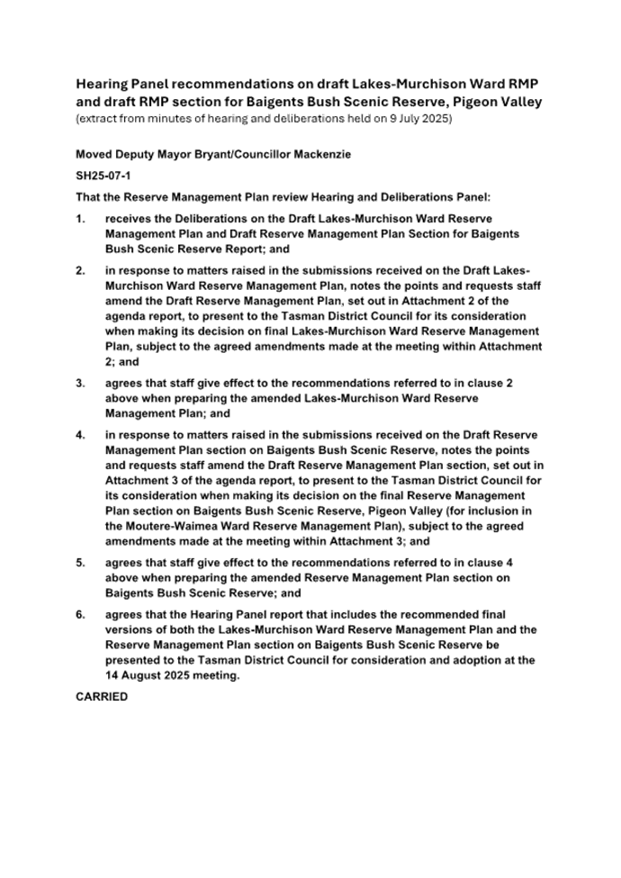
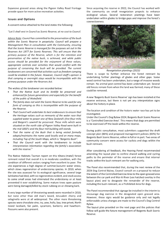
4.12 During deliberations, the Hearing Panel made
detailed recommendations for amending both draft documents (see the minutes of
the hearing and deliberations meeting held on 9 July 2025).
4.13 Staff have amended both the Lakes-Murchison Ward
Reserve Management Plan and RMP section for Baigents Bush Scenic Reserve,
Pigeon Valley, as per these Hearing Panel directions and recommendations.
4.14 The Hearing Panel has reviewed the amended text of
both documents and recommends that the Council considers and adopts:
· the amended Plan as the final Lakes-Murchison Ward Reserve
Management Plan; and
· the amended RMP section as the final section for Baigents Bush
Scenic Reserve, Pigeon Valley, for inclusion within the Moutere-Waimea Ward
Reserve Management Plan (2022).
5. Analysis
and Advice / Tātaritanga me ngā tohutohu
5.1 A copy of the amended Lakes-Murchison
Ward Reserve Management Plan is included as Attachment 2 to this report.
A copy of the amended RMP section on Baigents Bush Scenic Reserve, Pigeon
Valley, is included as Attachment 3 to this report. Tracked-change
versions of both amended documents are available on request.
5.2 The significant amendments that the
Hearing Panel recommended be incorporated into the final Lakes-Murchison Ward
RMP are summarised below:
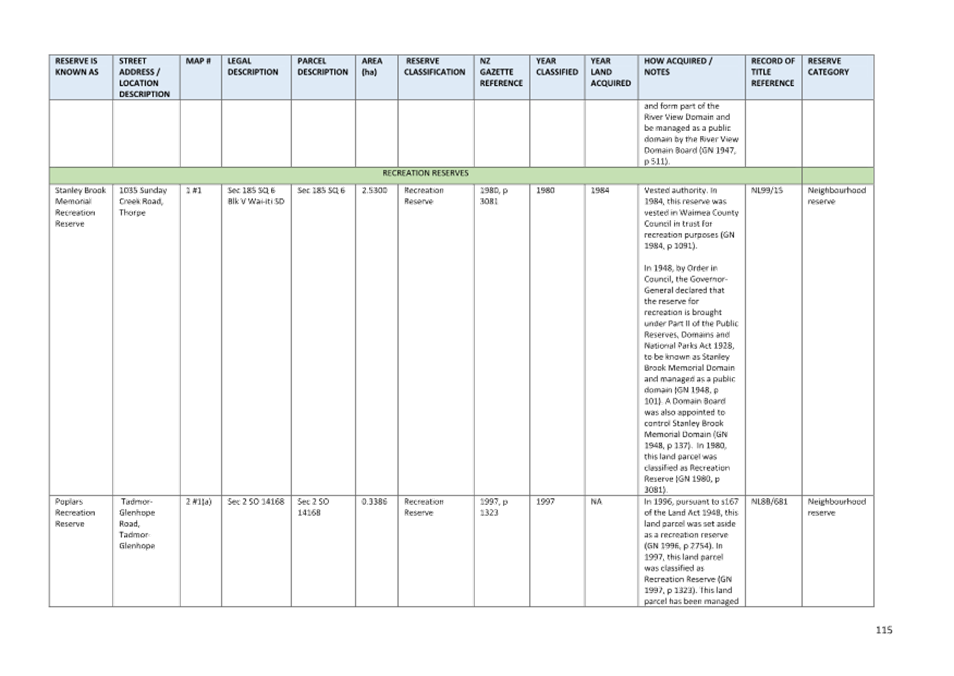
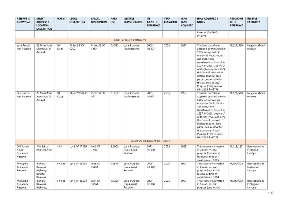
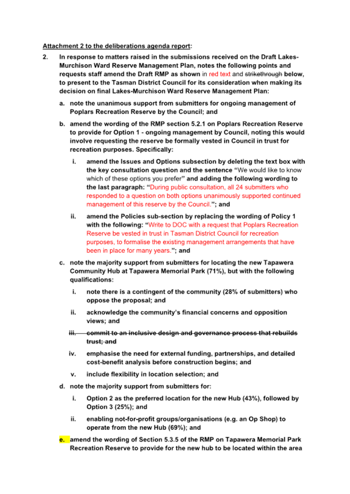
5.2.1 RMP section 5.2.1 ‘Poplars Recreation
Reserve’ has been amended to reflect the unanimous preference of
submitters for continued management of this reserve by the Council.
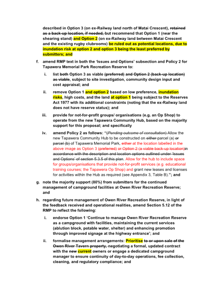
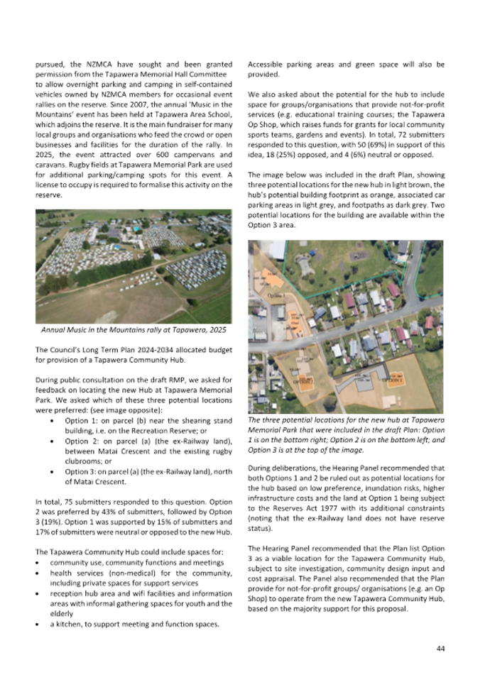
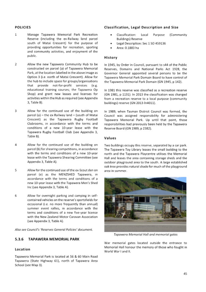
5.2.2 RMP section 5.3.5 ‘Tapawera Memorial Park
Recreation Reserve’ has been amended to provide for the proposed Tapawera
Community Hub to be constructed on the ex-Railway land parcel north of Matai
Crescent, but to rule out sites within the grounds of Tapawera Memorial Park
(i.e. all land south of Matai Crescent) as locations for the new hub. The RMP
has also been amended to provide for not-for-profit groups/organisations (e.g.
an Op Shop) to operate from the new hub, based on the majority support for this
proposal.
5.2.3 RMP section 5.12 ‘Owen River Recreation
Reserve’ has been amended to provide for continued management of the
campground and ongoing maintenance of its basic facilities, enhanced promotion
of the campground, formalisation of the management arrangements, and
environmental and access improvements.
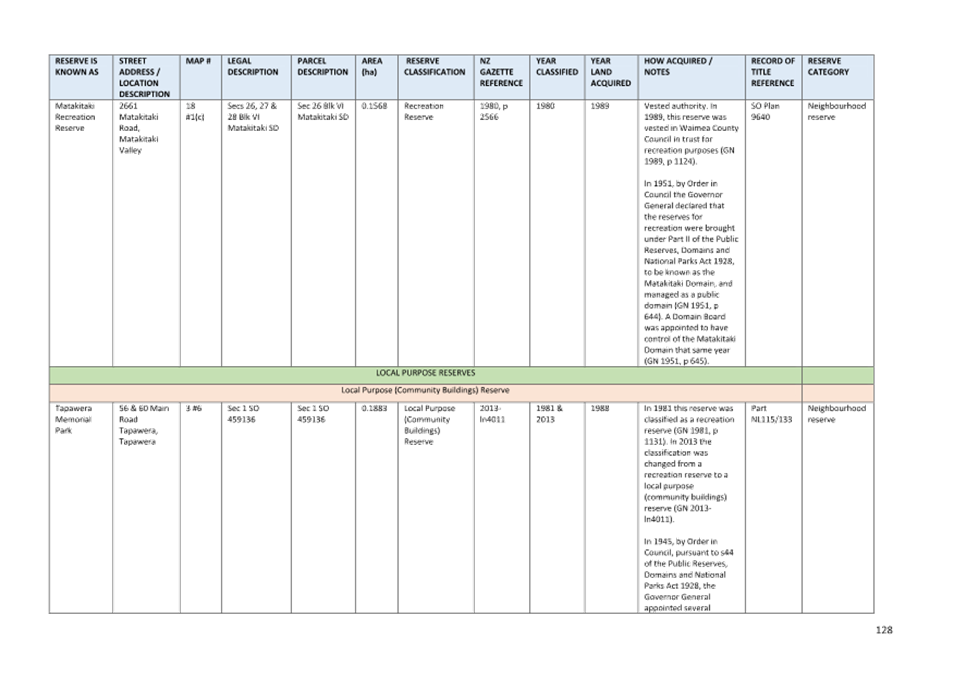
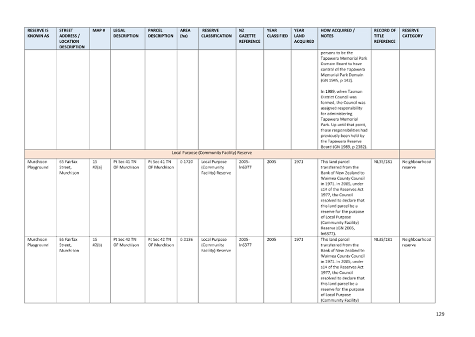
5.2.4 RMP section 5.17 ‘Lower Maruia Recreation
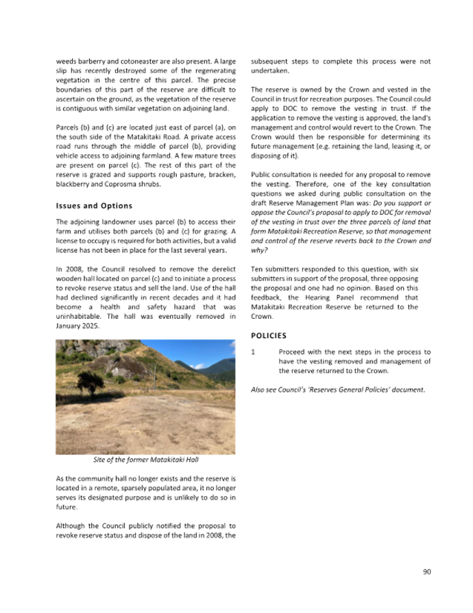
Reserve’ and section 5.18 ‘Matakitaki Recreation Reserve’
have both been amended to align with the proposal preferred by the majority of
submitters, i.e. to divest both reserves back to the Crown.
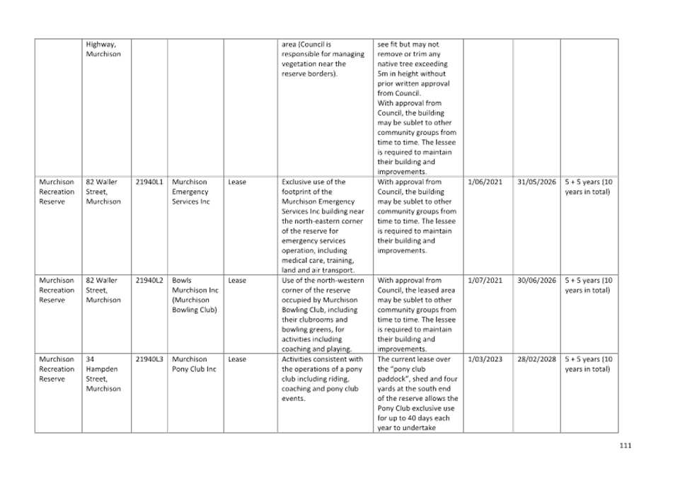
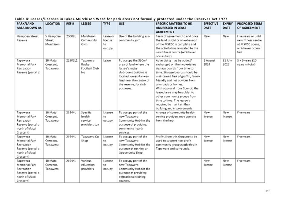
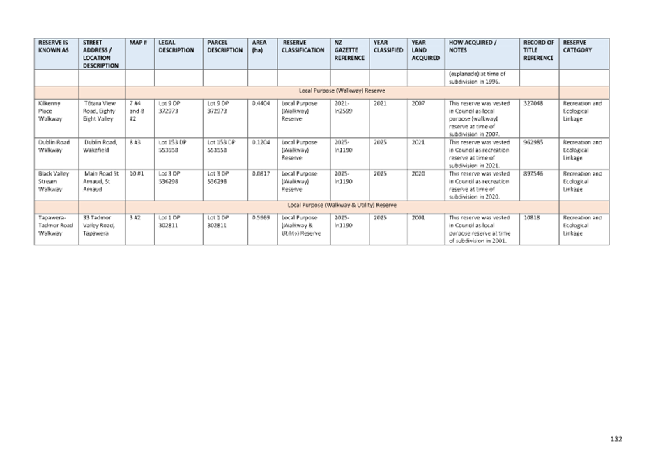
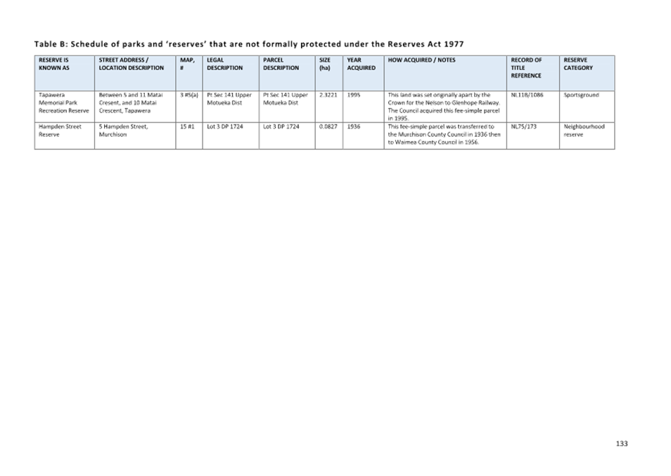
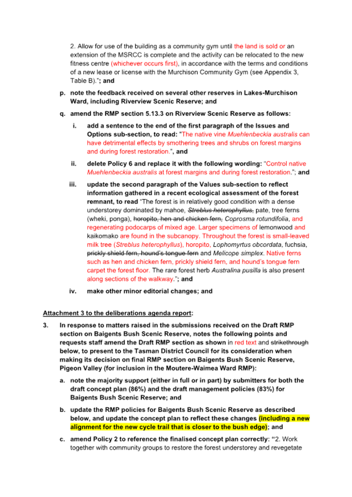
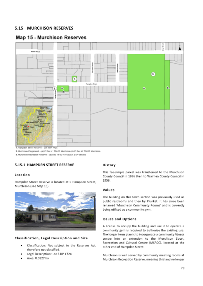
5.2.5 RMP section 5.15.1 ‘Hampden Street Reserve’
has been amended to direct the Council to initiate the process to dispose of
the land and building at 5 Hampden Street, Murchison, and to allow for use of
the building as a community gym via a new lease or licence, until such time as
the land sells or the building is no longer needed for a gym.
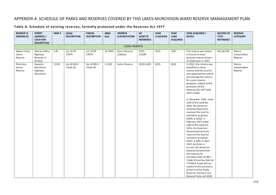
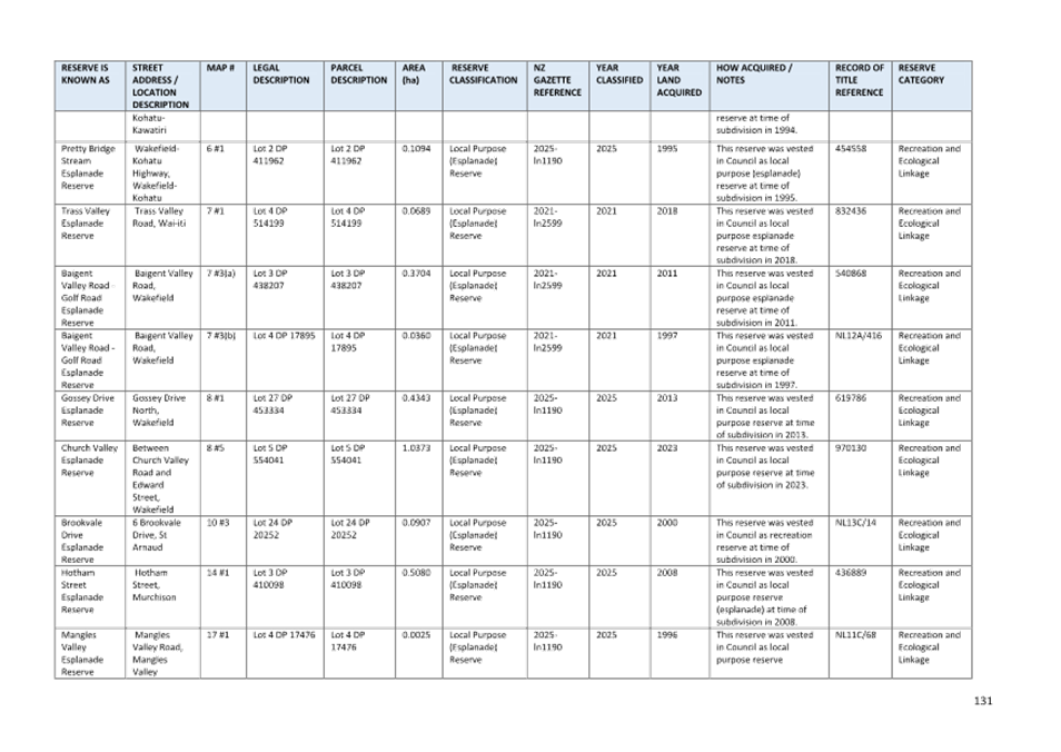
5.2.6 RMP section 5.13.3 ‘Riverview Scenic
Reserve’ has been amended to update the description under the
‘Values’ subsection and provide for control of Muehlenbeckia
australis at forest margins and during forest restoration.
5.3 The significant amendments that the
Hearing Panel recommended be incorporated into the final RMP section on
Baigents Bush Scenic Reserve are summarised below:
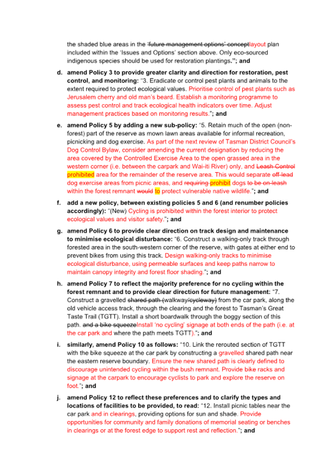
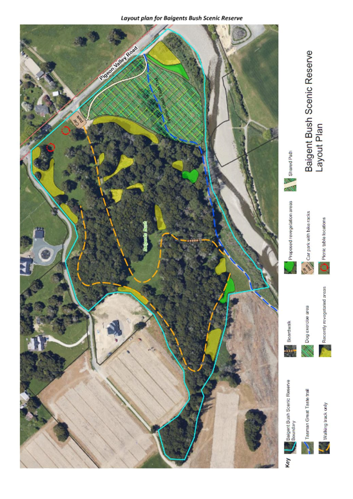
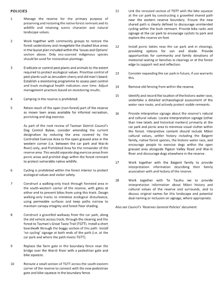
5.3.1 The final layout plan and policies have been
amended to:
· restrict cycling to the outskirts of the bush remnant; and
· encourage dog exercise on the open grassed area between the car park
and Wai-iti River but discourage dogs within the remaining areas of the
reserve.
5.3.2 Other amendments to policies include:
· guidance for consideration when the Dog Control Bylaw 2024 is
reviewed;
· expansion of the policy on pest plant and animal control to include
priorities and monitoring measures;
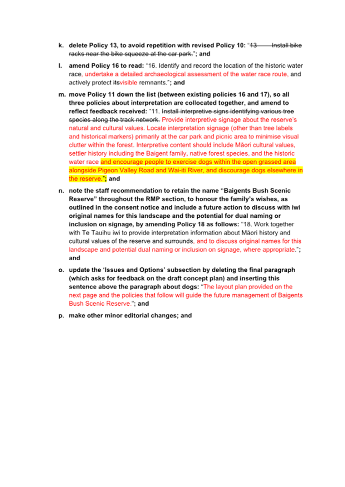
· limiting tracks within the forest remnant part of the reserve to
walking-only and additional guidance on their design specifications;
· provision for additional seating, including memorial seats;
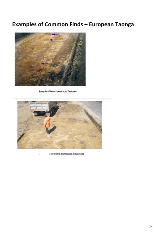
· including the need for an archaeological assessment of the water
race route;
· updates and expansion to the policy on reserve signage; and
· expansion of the policy on working with iwi to include discussion on
original names for this landscape and potential dual naming or inclusion on
signage.
Further amendments to RMP section for Baigents Bush Scenic Reserve
5.4 The original recommendations from the
Hearing Panel included a direction to Council staff to include a reference to
the updated layout plan within the ‘Issues and Options’ subsection
for Baigents Bush, but did not provide direction on expanding the discussion
text to provide background context on submissions received and how policies had
been amended in response. Hearing Panel members considered this matter via
email following the deliberations.
5.5 The Panel members recommended that the
following contextual information be included near the end of the ‘Issues
and Options’ subsection of the RMP section for Baigents Bush Scenic
Reserve:
“During
public consultation, most submitters supported the draft concept plan (86%) and
proposed management policies (83%) for Baigents Bush Scenic Reserve, either in
full or in part. Two areas of community concern were access for cyclists and
dogs within the bush remnant.
After
considering all feedback, the Hearing Panel recommended amending the layout
plan to confine shared walking and cycling paths to the perimeter of the
reserve and ensure that internal tracks within the bush remnant are for walking
only.
The Panel
also recommended that, during the next review of the 2024 Dog Control Bylaw,
Council consult on a proposal to reduce the extent of the Controlled Exercise
Area to the open grassed area between the car park and Wai-iti River (see
hatched overlay in the layout plan) and to designate the remainder of the
reserve, including the bush remnant, as a Prohibited Area for dogs.
The Panel
recommended that signage be installed in the interim to encourage dog exercise
in the designated open grassed area. However, these signs would be guidance
only and not legally enforceable unless changes are made to the Council’s
Dog Control Bylaw.”
5.6 Staff have updated the amended RMP
section included in Attachment 3 to include this additional contextual
information.
6. Financial
or Budgetary Implications / Ngā Ritenga ā-Pūtea
6.1 The Council has provided the budget for
preparation of both RMP documents in its Long Term Plan 2024-2034.
6.2 The costs associated with development of
the Plan have been absorbed within the Service and Strategy Group.
6.3 There will be costs associated with
implementing some of the recommended changes in the RMPs. Provision for some of
these will come from existing reserve budgets, while others will need to be
considered during future Council annual and long term planning processes.
6.4 By adopting the Plan and RMP section,
the Council is not committing to funding all projects identified, or to fund
them by a particular date. Some of the projects may involve contributions from
volunteers (particularly in terms of time and labour), thereby reducing the
financial costs associated with plan implementation. Where funding is required,
allocation of funds will be subject to the Council’s annual and long term
planning processes – i.e. will be balanced alongside all projects planned
within the District each year.
7.1 At the 9 July 2025 hearing and
deliberations meeting, the Hearing Panel considered all submissions and
feedback received on both draft documents. The Panel also formed
recommendations on how both drafts should be amended in response to submission
points that they accepted in full or in part. The Hearing Panel recommendations
are summarised in section 5 of this report and further details are included
within the minutes of the deliberations meeting.
7.2 The Hearing Panel recommendations of 9
July 2025 have been given effect to in the wording of the amended Plan (see Attachment
2) and amended RMP section (see Attachment 3). The Council is being
asked to consider both amended documents and then adopt these as the final
Lakes-Murchison Ward Reserve Management Plan and final RMP section on Baigents
Bush Scenic Reserve, Pigeon Valley (the latter is to be included in the Moutere-Waimea
Ward RMP 2022).
7.3 The options are outlined in the
following table:
|
Option
|
Advantage
|
Disadvantage
|
|
1.
|
Agree to all the changes recommended by
the Hearing Panel and adopt the amended Plan (see Attachment 2) as the
final Plan and the amended RMP section (see Attachment 3) as the final
RMP section.
|
This option shows that submitter views
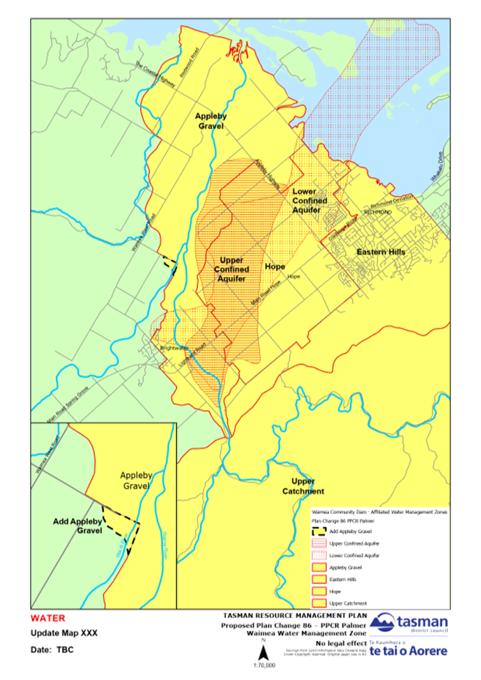
have been considered by the Hearing Panel and, where appropriate, amendments
have been made to the Plan and RMP section.
|
Not every submission point has been
accepted. Some submitters may therefore be disappointed that their
suggestions were not given effect in the amended Plan/RMP section. However,
this is part of the public submission process, and not all suggestions will
be appropriate or can be adopted.
|
|
2.
|
Agree to some of the changes recommended
by the Hearing Panel, reject other changes and/or make further amendments to
the Plan/RMP section text before finalising and adopting the Plan/RMP
section.
|
Option 2 has similar advantages to Option
1. An additional advantage is that it would enable the Council to make
amendments to the Plan/RMP section before it is finalised if not all the
Hearing Panel’s recommendations are accepted.
|
Option 2 has similar disadvantages to
Option 1. Additionally, not all elected members were present to hear
submitter views and were not part of the deliberations.
|
|
3
|
Adopt the Draft Plan and/or draft RMP
section as the final Plan/RMP section without amendment, other than the
amendments necessary to change the Plan/RMP section from a
“draft” to a “final” Plan/RMP section.
|
Limited/no advantages.
|
The Council will be open to criticism for
not listening to the community’s views through the public consultation
process.
|
7.4 Option 1 is recommended.
8.1 The Council has followed the correct
procedure for preparing the Plan and RMP section, as required under the
Reserves Act 1977. Detailed descriptions of this process, including engagement
with iwi and the initial consultation round undertaken during the summer of
2023/2024, were included in previous reports on this matter.
9. Iwi
Engagement / Whakawhitiwhiti ā-Hapori Māori
9.1 Iwi actively engaged in the Plan review
throughout the whole process. Two of the five Hearing Panel members were
mātauranga Māori experts nominated by iwi.
10. Significance
and Engagement / Hiranga me te Whakawhitiwhiti ā-Hapori Whānui
10.1 The Lakes-Murchison Ward Reserve Management Plan
and RMP section on Baigents Bush Scenic Reserve, Pigeon Valley, are both
moderately significant for our community as they impact on their use and
enjoyment of parks and reserves. The public consultation procedure followed
enabled the public to provide us with their views about the appropriateness or
otherwise of the Draft Plan and draft RMP section. The amendments proposed are
in line with submissions made on the Draft Plan and draft RMP section and are not
of high significance. Therefore, the Council can adopt the recommendations of
the Hearing Panel without undertaking further consultation.
|
|
Issue
|
Level of
Significance
|
Explanation of
Assessment
|
|
1.
|
Is there a high level
of public interest, or is decision likely to be controversial?
|
Medium
|
The Plan is of medium
significance to residents and visitors to the Lakes-Murchison Ward because it
sets policy direction for the use and management of approximately 34 parks
and reserves.
The RMP section is of medium
significance to residents of Wakefield and surrounds because it sets policy
direction for the use and management of the recently acquired Baigents Bush
Scenic Reserve, Pigeon Valley.
|
|
2.
|
Are there impacts on
the social, economic, environmental or cultural aspects of well-being of the
community in the present or future?
|
Low
|
Implementation of the
Plan and RMP section will enhance future well-being.
|
|
3.
|
Is there a
significant impact arising from duration of the effects from the decision?
|
Medium
|
The Plan and RMP section are
both likely to be in place for 10 years.
|
|
4.
|
Does the decision
relate to a strategic asset? (refer Significance and Engagement Policy for
list of strategic assets)
|
N/A
|
|
|
5.
|
Does the decision
create a substantial change in the level of service provided by Council?
|
Low
|
The Plan will enhance the levels
of service at a number of parks and reserves, however no major changes are
proposed.
The RMP section will enhance the
level of service at Baigents Bush with the addition of new amenities.
|
|
6.
|
Does the proposal,
activity or decision substantially affect debt, rates or Council finances in
any one year or more of the LTP?
|
Low
|
The Plan and RMP section outline
several development plans for specific parks and reserves. However, budget
allocation decisions will be made separately, as part of future annual and
long term plan processes. See paragraph 6.4 above.
|
|
7.
|
Does the decision
involve the sale of a substantial proportion or controlling interest in a CCO
or CCTO?
|
N/A
|
|
|
8.
|
Does the
proposal or decision involve entry into a private sector partnership or
contract to carry out the deliver on any Council group of activities?
|
N/A
|
|
|
9.
|
Does the proposal or
decision involve Council exiting from or entering into a group of
activities?
|
N/A
|
|
|
10.
|
Does the proposal
require particular consideration of the obligations of Te Mana O Te Wai
(TMOTW) relating to freshwater or particular consideration of current
legislation relating to water supply, wastewater and stormwater
infrastructure and services?
|
Low
|
One of the reserves
included in the draft RMP (the Tapawera-Tadmor Road Walkway) has been
classified as a Local Purpose (Walkway and Utility) Reserve as it currently
contains the water supply for Tapawera. This infrastructure is proposed to be
moved to another site across the road within the next 10 years.
|
11. Communication
/ Whakawhitiwhiti Kōrero
11.1 Communication has been covered in previous reports.
Consultation on the draft documents was advertised and promoted on the
Council’s website, social media channels, Shape Tasman and Newsline. Iwi,
stakeholders and those who had previously submitted ideas for the draft Plans
were directly notified via email when the draft documents were publicly
notified.
11.2 Once the final documents are adopted, staff will
publish these on the Council’s website, update the Shape Tasman project page and
write to all submitters to advise them of the outcome.
12.1 Risks associated with the matters contained in the
Plan and RMP section have been addressed in previous reports.
13. Climate
Change Considerations / Whakaaro
Whakaaweawe Āhuarangi
13.1 The Plan includes objectives and policies that
align with the Tasman Climate Response and Resilience Strategy and Action Plan
2024-2035.
14. Alignment
with Policy and Strategic Plans / Te Hangai ki ngā aupapa Here me ngā
Mahere Rautaki Tūraru
14.1 In 2013, the Minister of Conservation delegated a
number of responsibilities under the Reserves Act 1977 to local authorities,
including the ability to adopt reserve management plans under section 41 of
that Act.
15. Conclusion
/ Kupu Whakatepe
15.1 The Council has undertaken an extensive public
consultation process, initially seeking ideas for inclusion in both draft
documents during the summer of 2023/2024. The Hearing Panel has then heard and
deliberated on written and oral submissions on the drafts that were publicly
notified on 11 April 2025.
15.2 The Hearing Panel recommends that the Council adopt
both the amended Plan (Attachment 2) and amended RMP section (Attachment
3), incorporating numerous amendments made in response to matters raised by
submitters.
16. Next
Steps and Timeline / Ngā Mahi Whai Ake
16.1 The
final Lakes-Murchison Ward Reserve Management Plan and final RMP section for
Baigents Bush Scenic Reserve will both come into effect following adoption by
the Council.
16.2 Staff
will publish the final documents on the Council’s website and make hard
copies available in our offices and libraries.
16.3 Staff
will also respond to all submitters in writing, advising them of the
Council’s decisions on the matters they raised.
16.4 Staff
will work with iwi, community groups and others to implement the objectives and
policies outlined in the final plans. The Council will consider budget
requirements for specific projects via annual plan and long term plan
processes.
|
1.⇩
|
Hearing
Panel Recommendations
|
24
|
|
2.⇩
|
Lakes-Murchison
Ward Reserve Management Plan (August 2025)
|
31
|
|
3.⇩
|
RMP
section on Baigents Bush Scenic Reserve (August 2025)
|
167
|
Tasman District
Council
Agenda – 14 August 2025

Tasman District Council Agenda – 14 August 2025


Tasman District
Council
Agenda – 14 August 2025
Tasman District Council Agenda – 14 August 2025
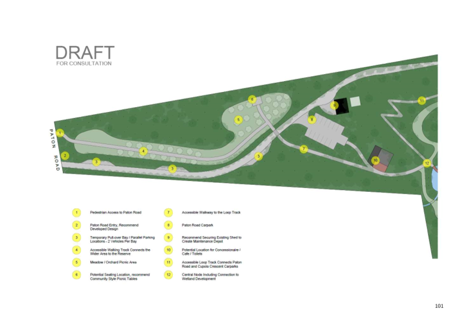
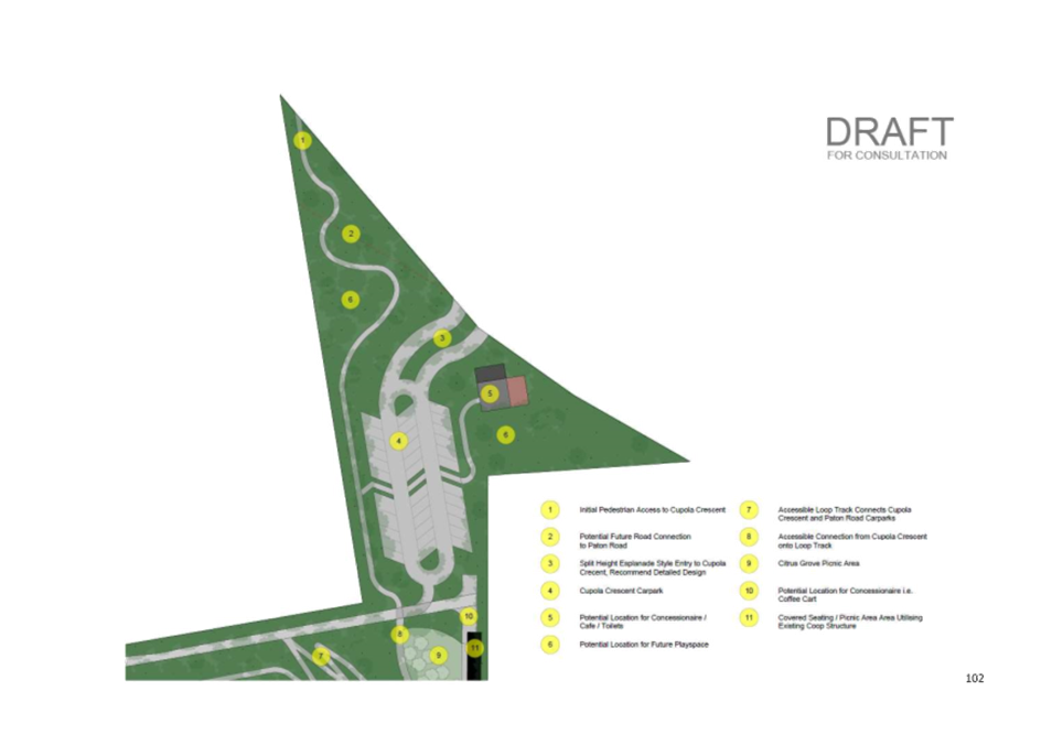
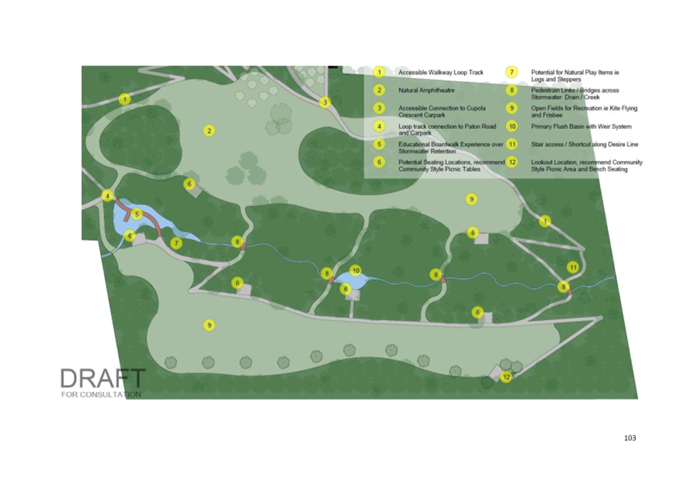
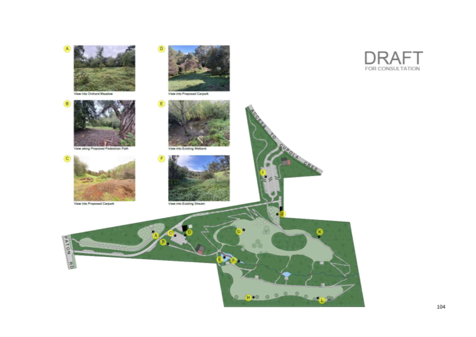
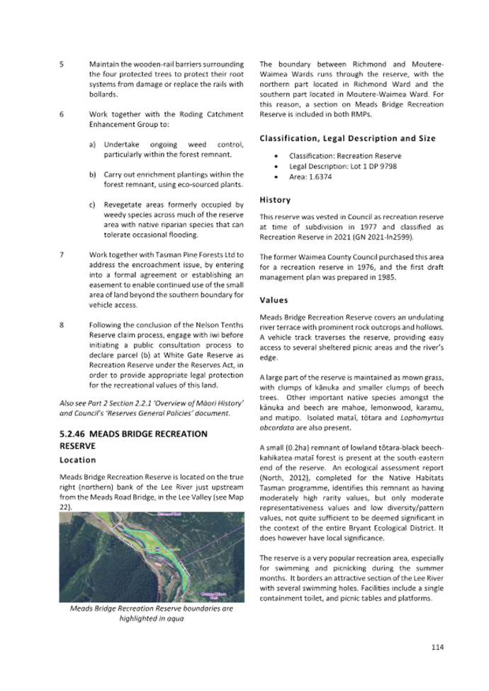
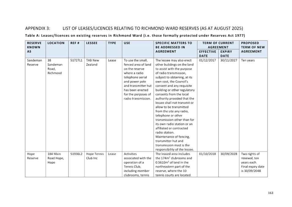
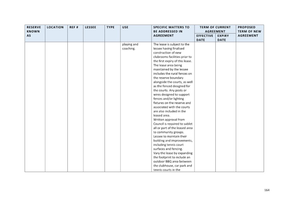
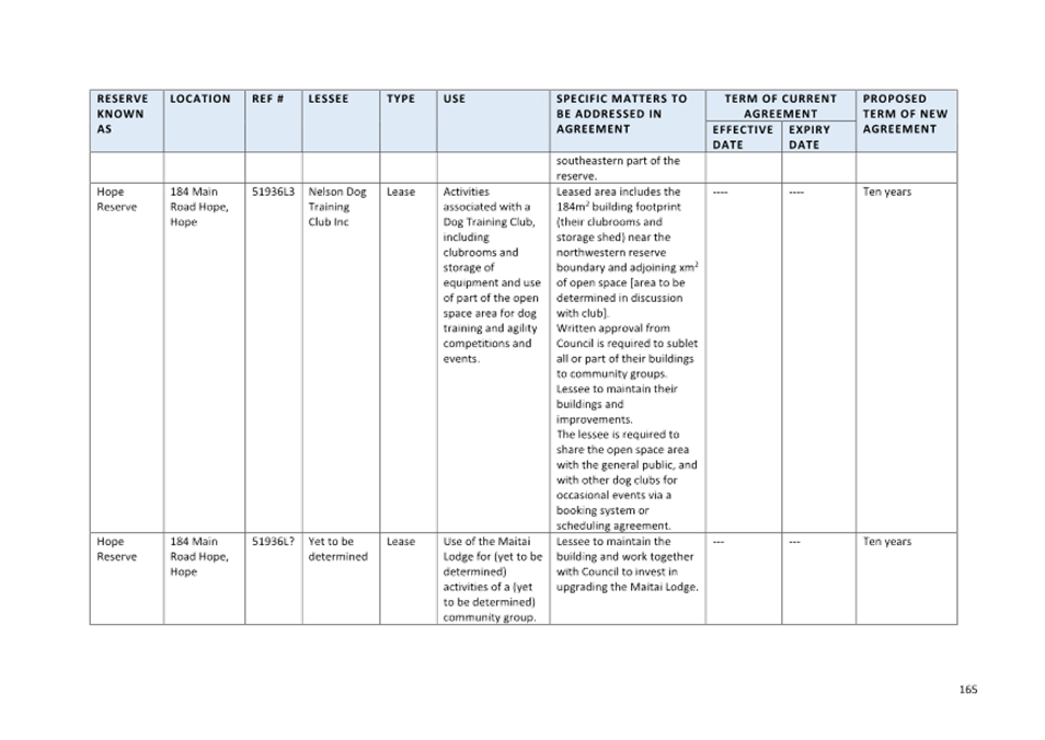
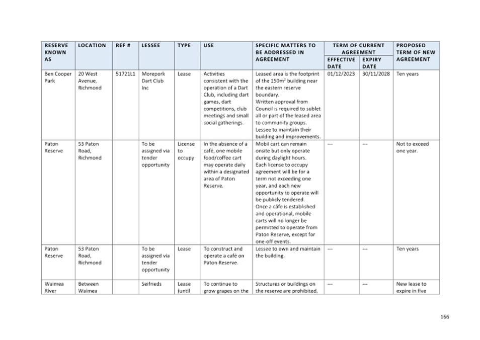
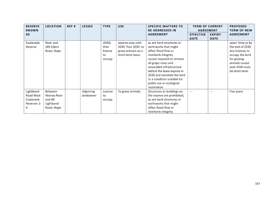
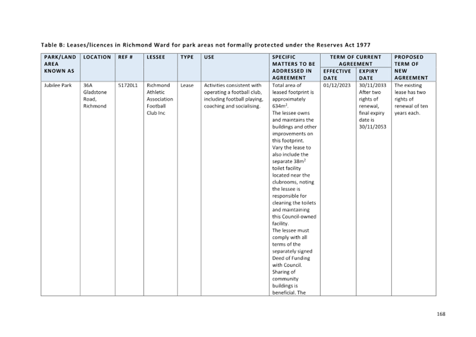
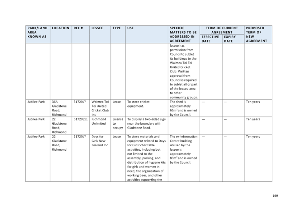
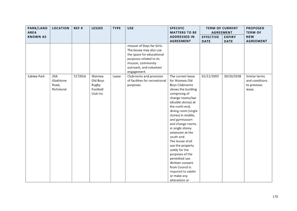
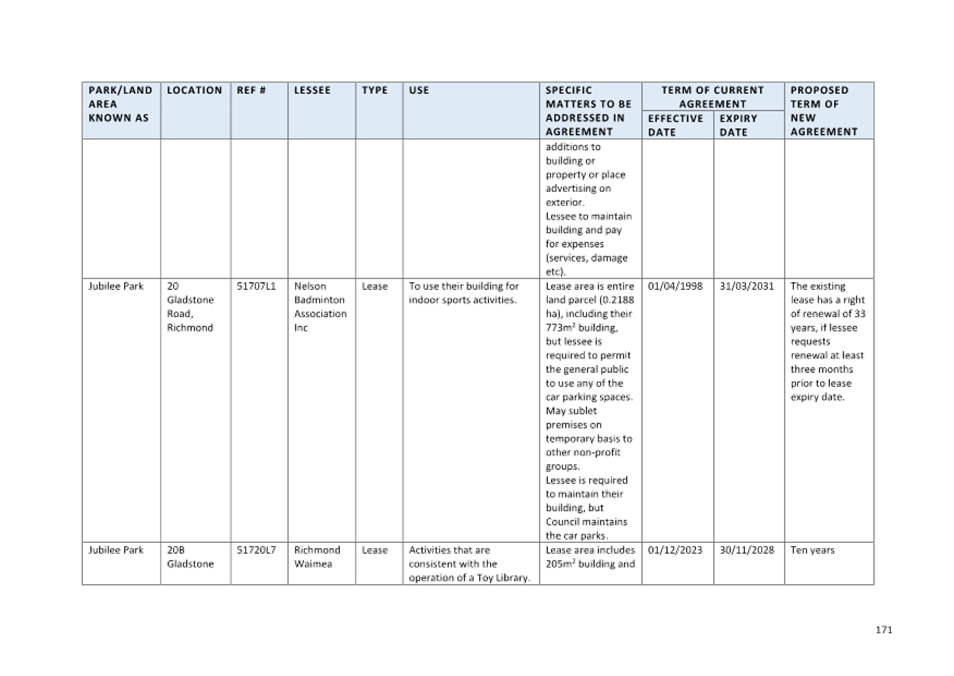
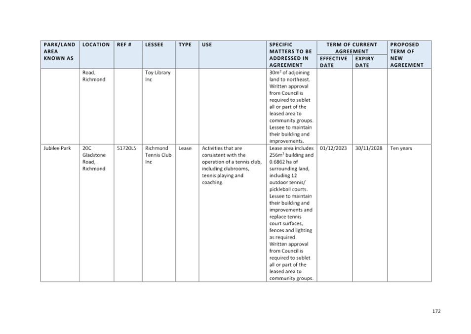
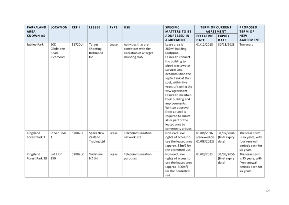
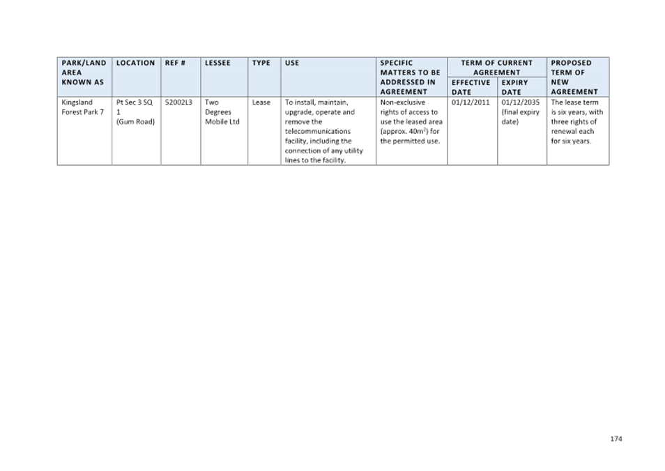
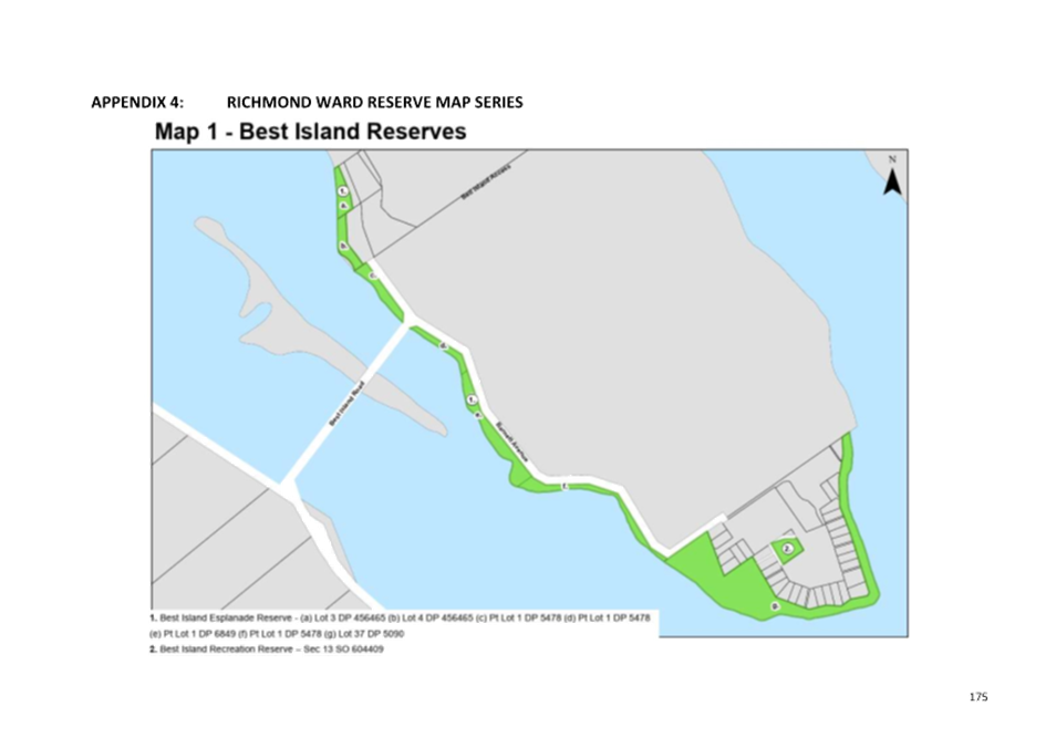
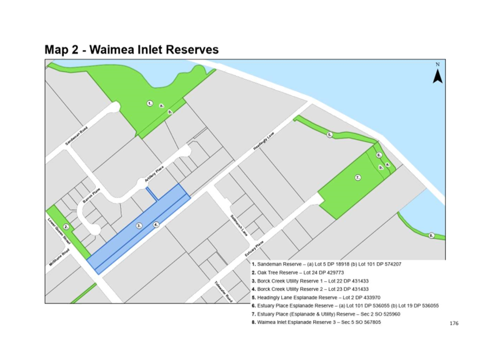
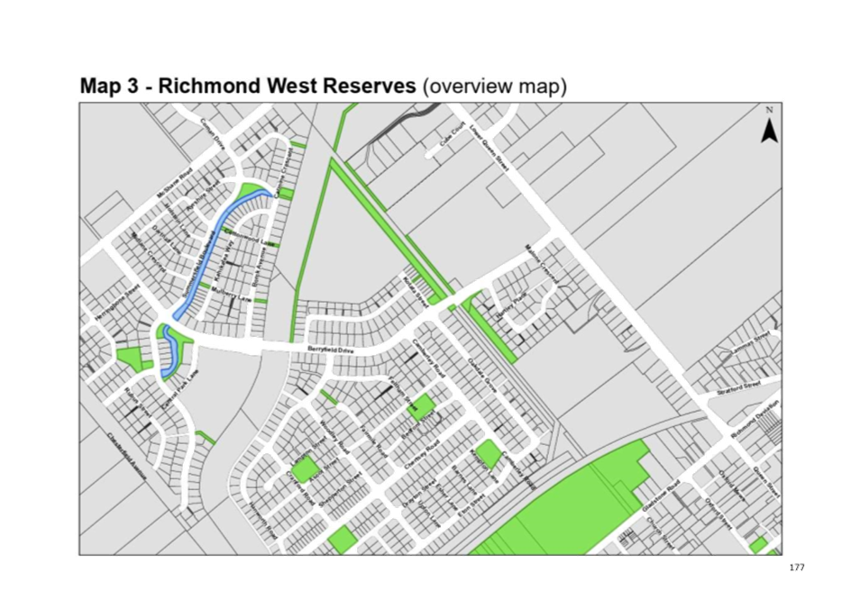
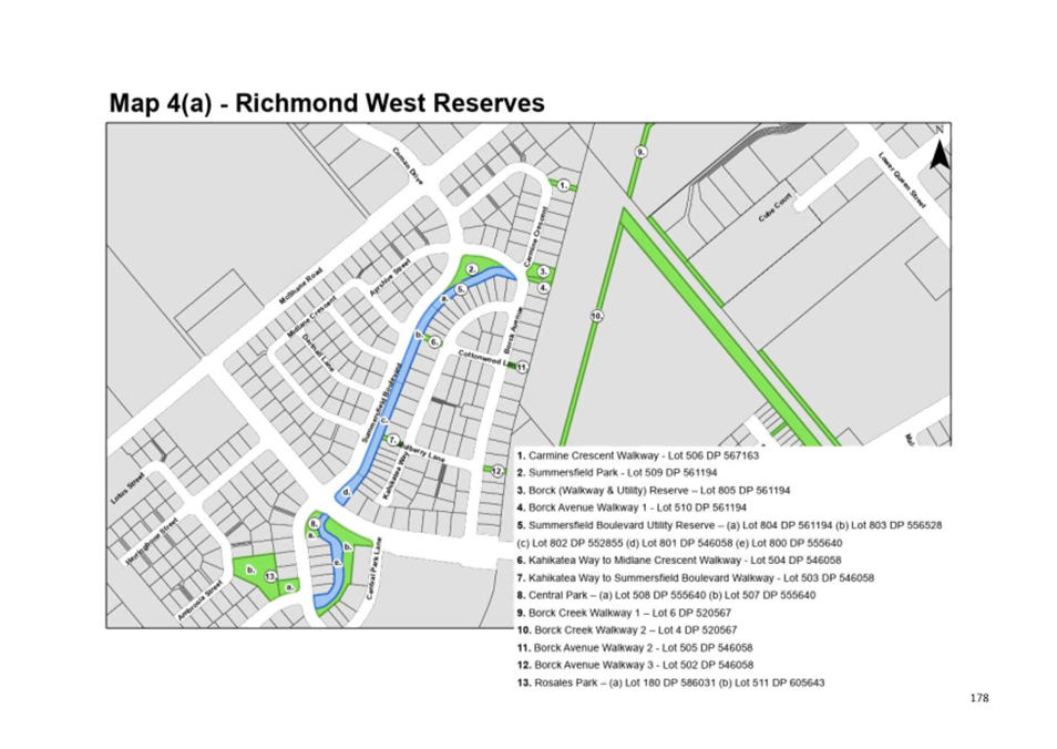
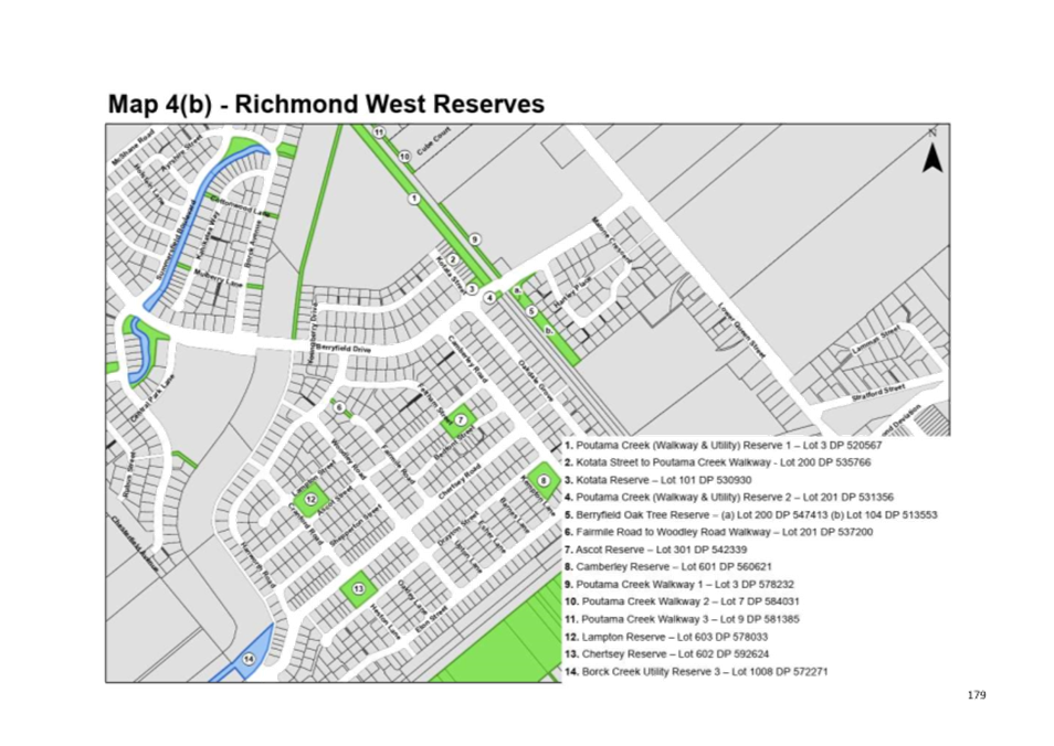
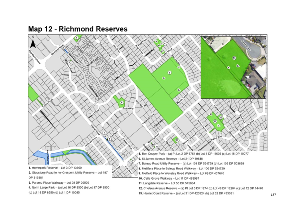
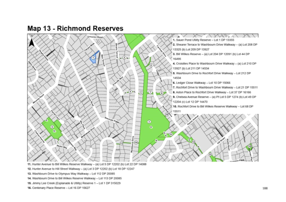
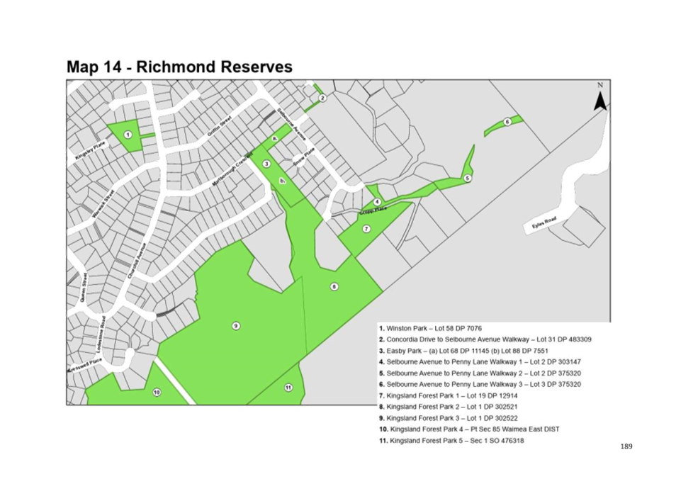
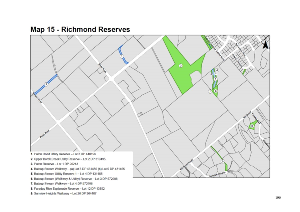
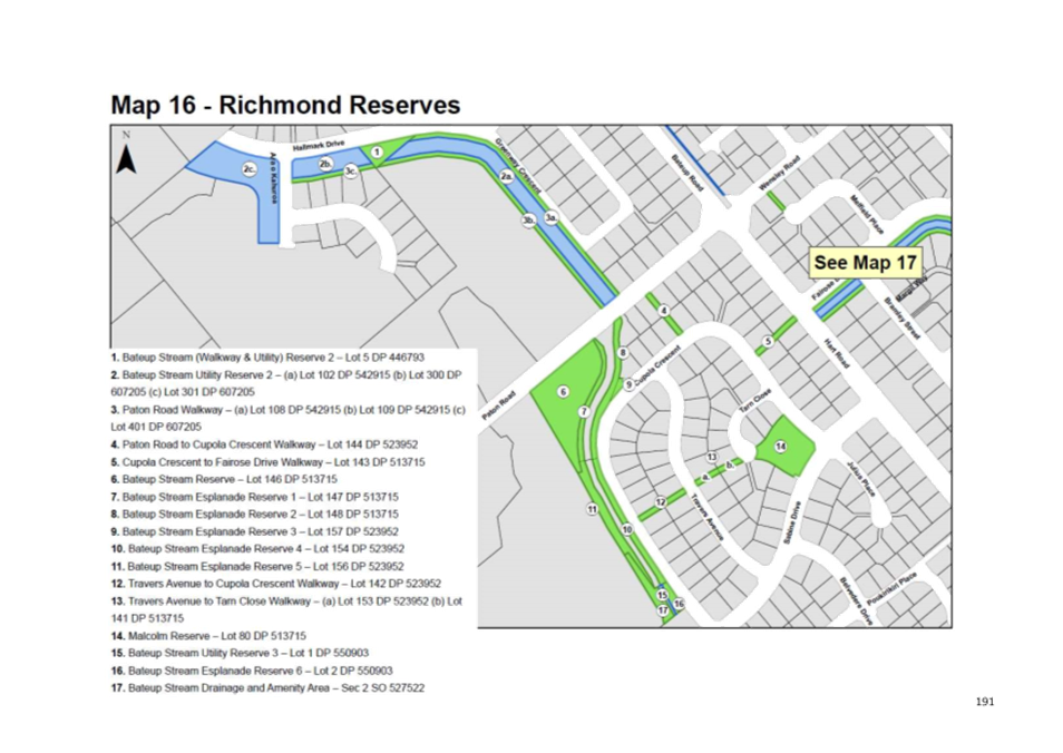
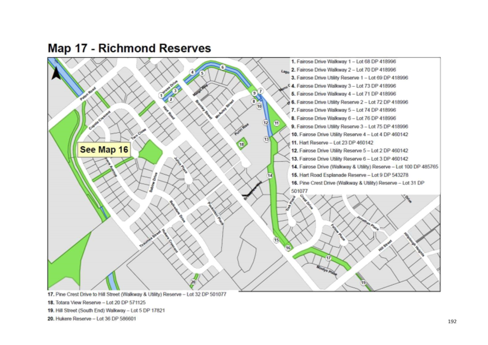
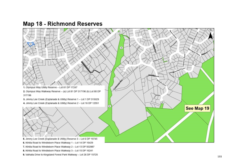
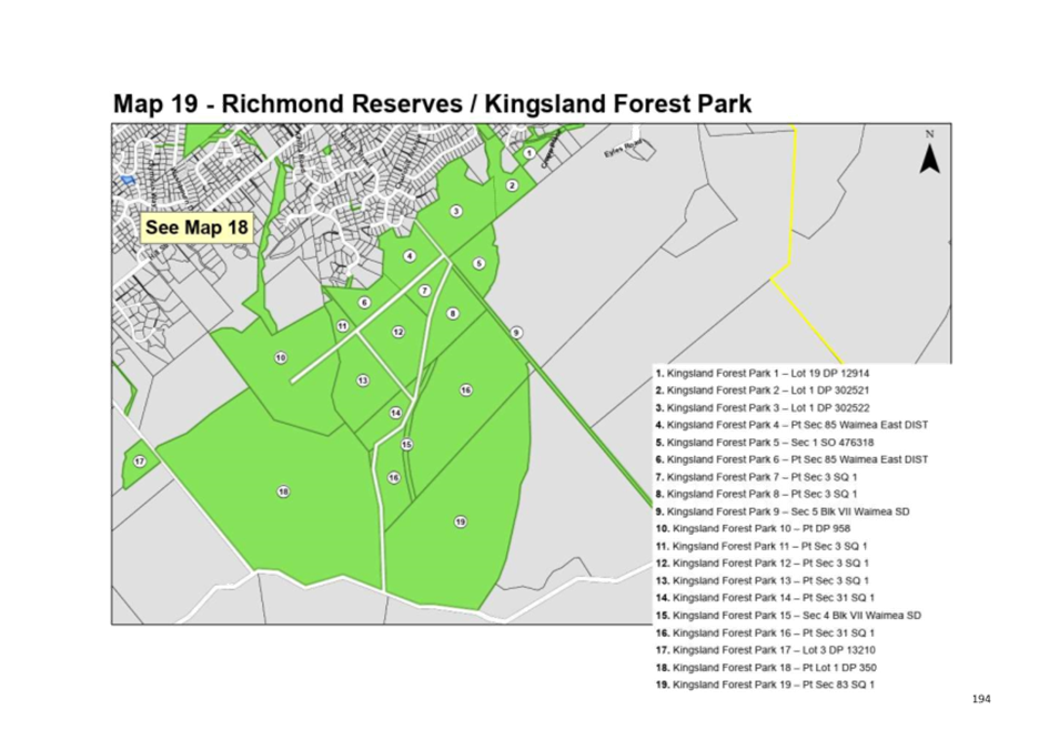
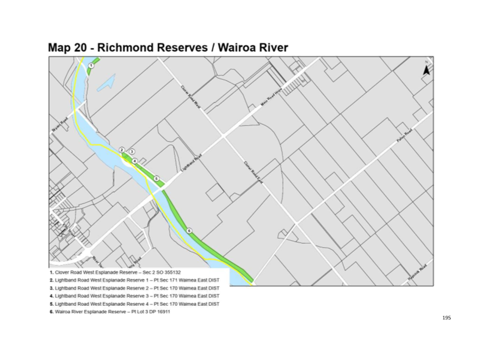
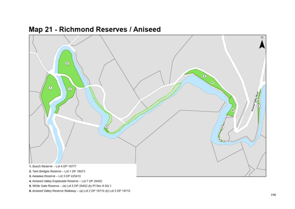
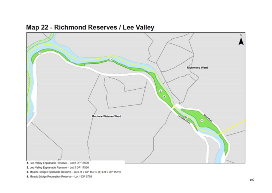
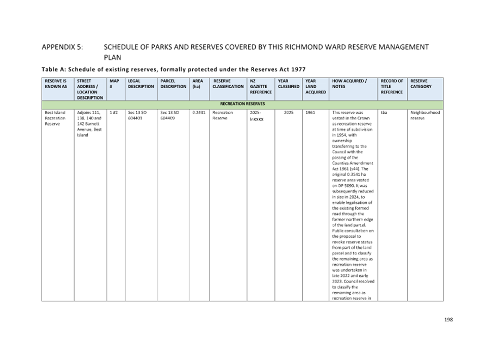
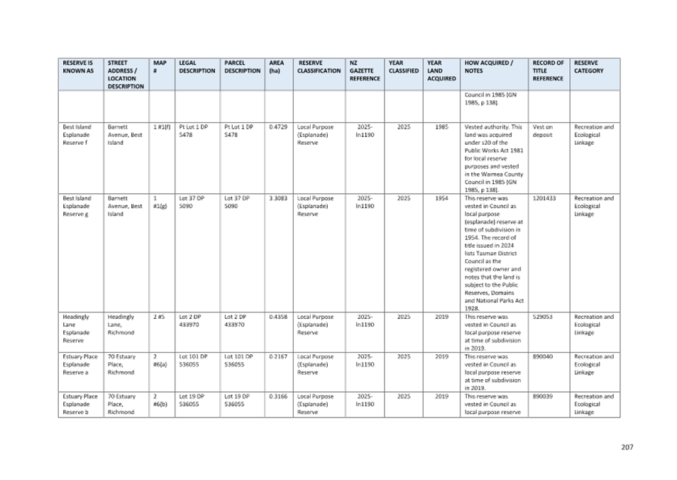
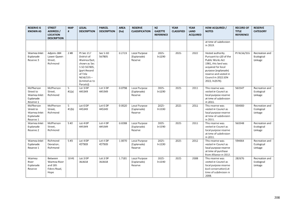
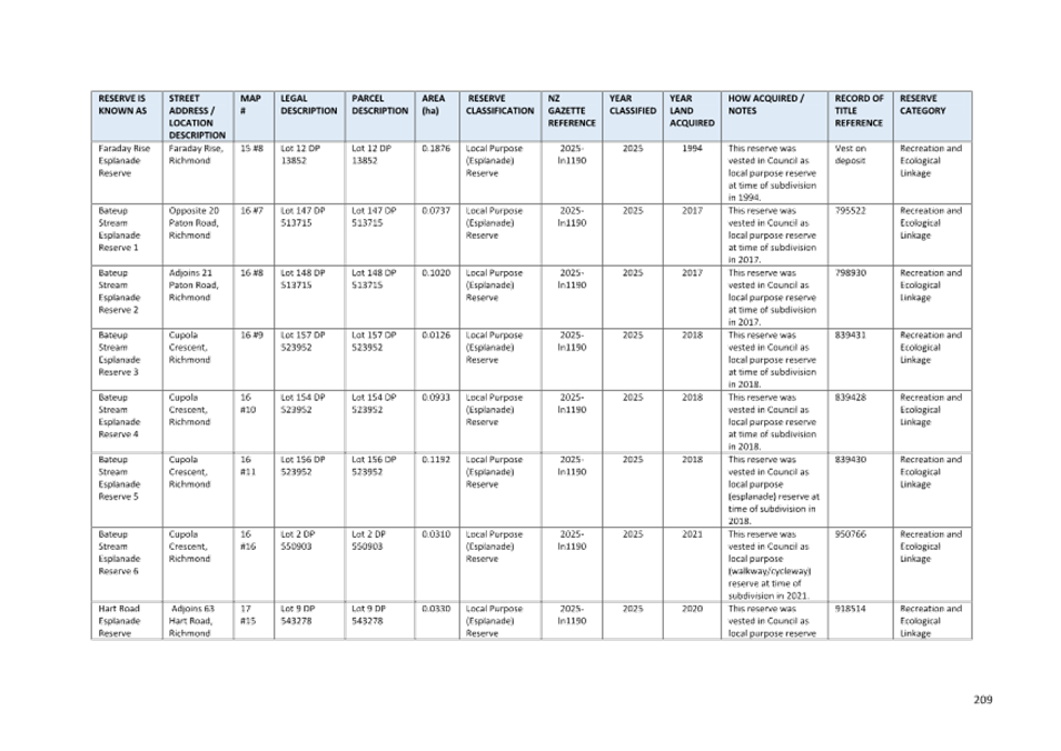
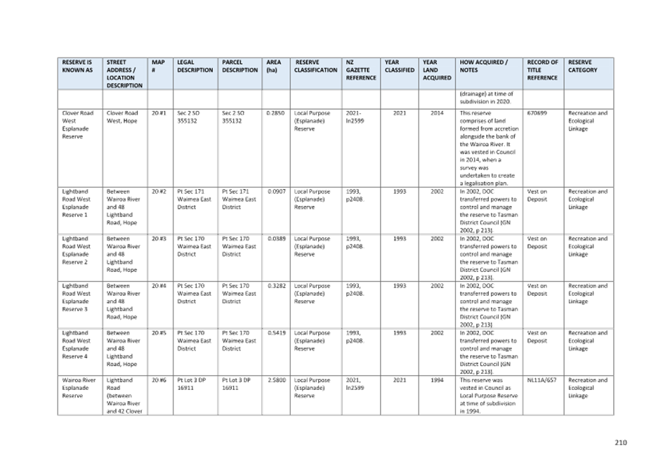
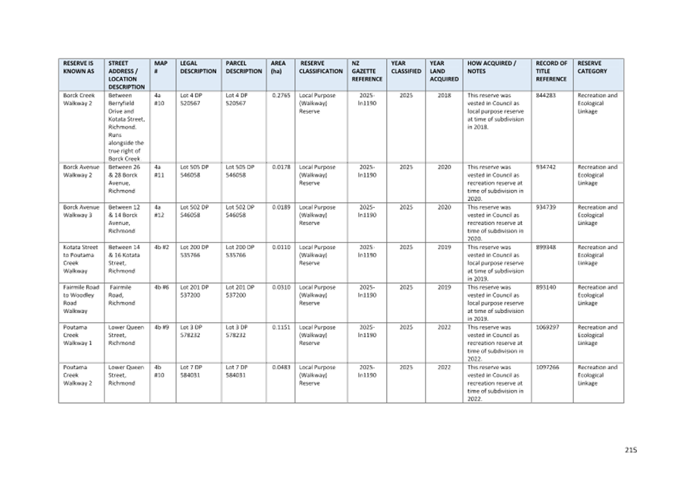
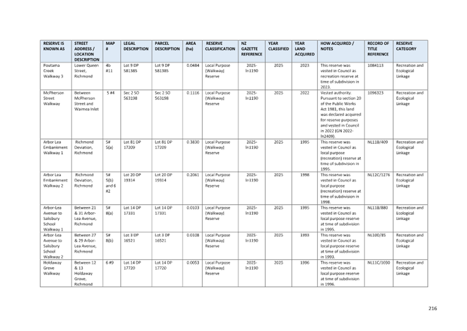
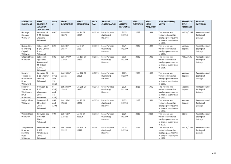
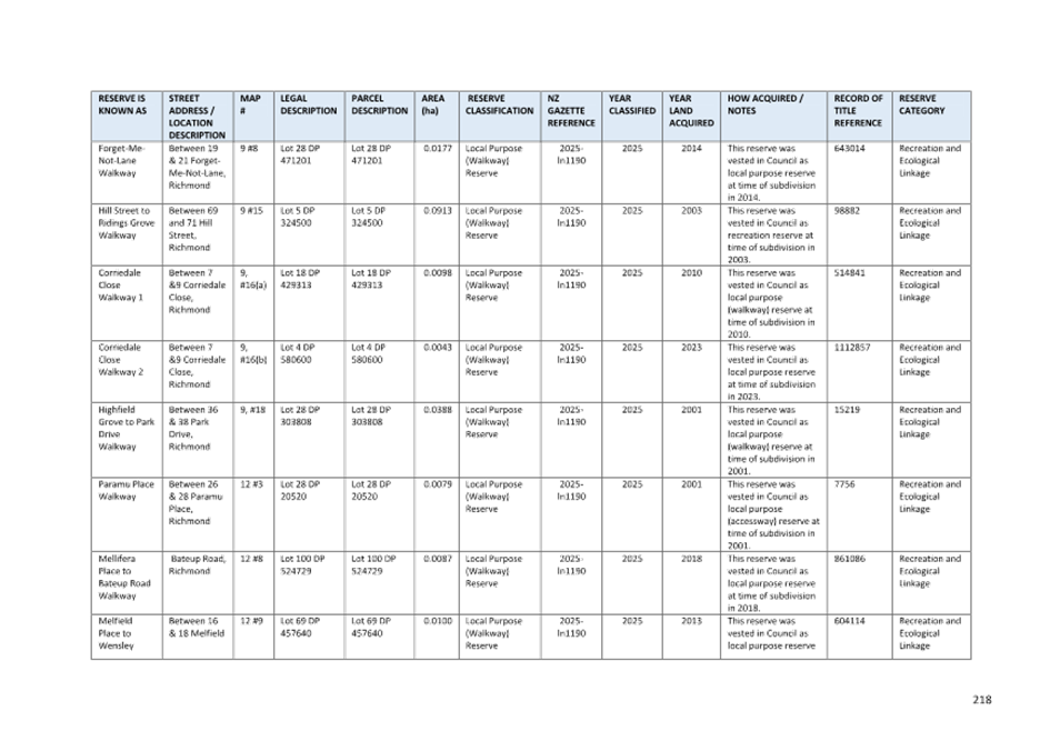
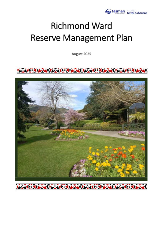
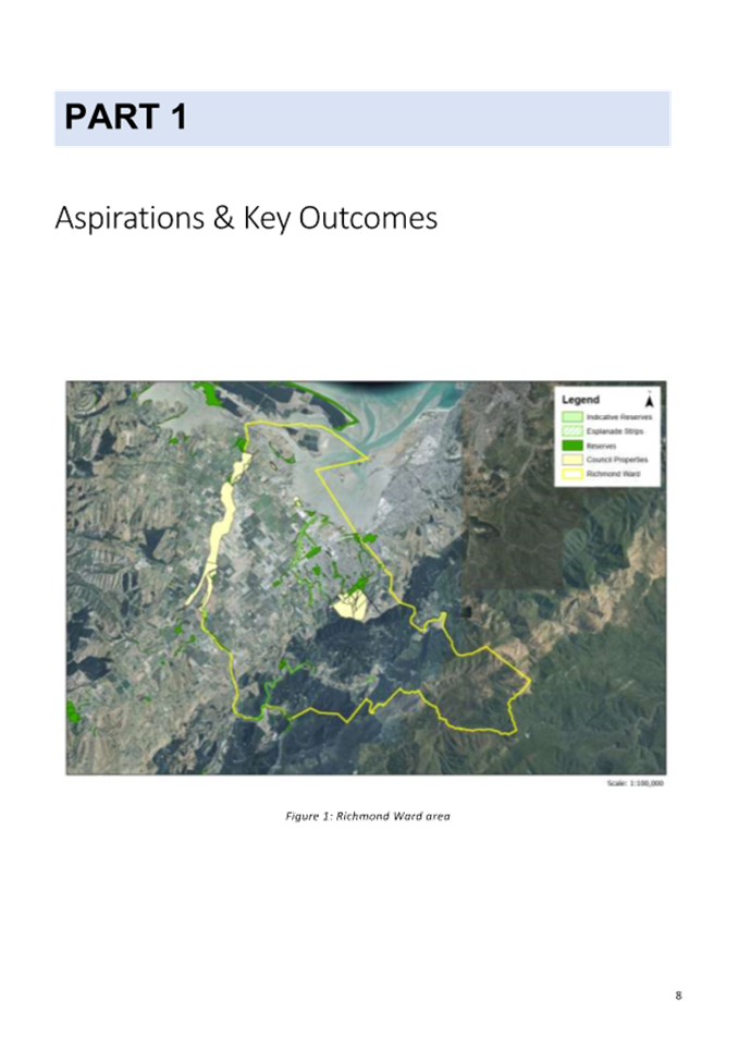
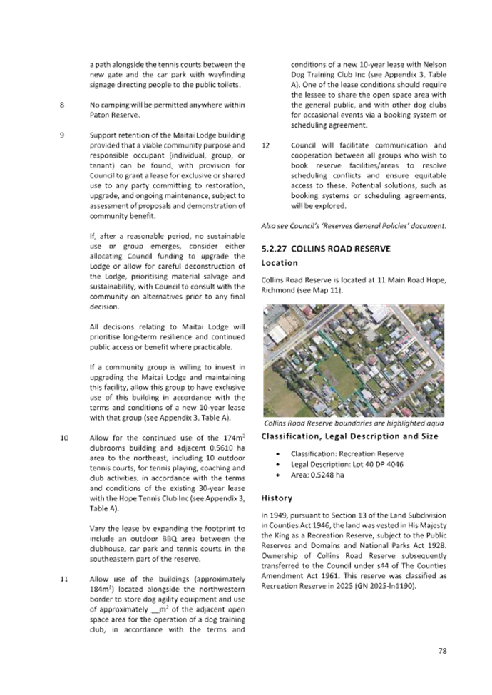
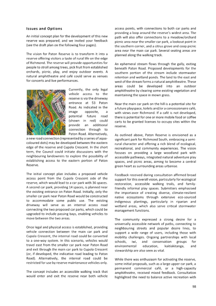
7.3 Adoption of the Richmond Ward Reserve Management
Plan
Decision Required
|
Report
To:
|
Tasman
District Council
|
|
Meeting
Date:
|
14
August 2025
|
|
Report
Author:
|
Anna
Gerraty, Senior Community Policy Advisor
|
|
Report
Authorisers:
|
Alan
Bywater, Team Leader - Community Policy; Grant Reburn, Reserves and
Facilities Manager; John Ridd, Group Manager - Service and Strategy
|
|
Report
Number:
|
RCN25-08-3
|
1. Purpose
of the Report / Te Take mō te Pūrongo
1.1 The
purpose of this report is for the Council to:
1.1.1 consider the recommendations of the Hearing Panel
appointed to hear submissions on the Draft Richmond Ward Reserve Management
Plan (Draft Plan) (see
Attachment 1); and
1.1.2 adopt the amended Plan (see Attachment 2) as the
final Richmond Ward Reserve Management Plan.
2. Summary
/ Te Tuhinga Whakarāpoto
2.1 The
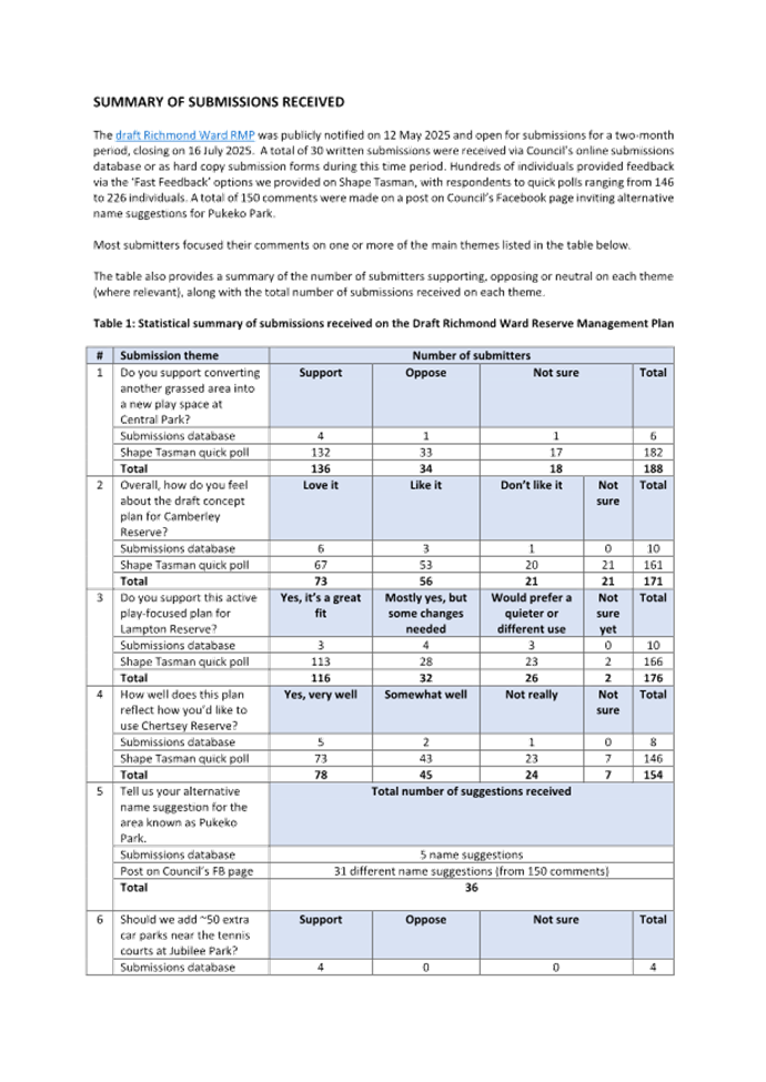
Draft Richmond Ward Reserve Management Plan was publicly notified on 12 May
2025 and open for submissions for two months. We received 30 submissions via
the Council’s online submissions database and hardcopy submission forms.
Hundreds of individuals also provided feedback on several reserves via a
‘Fast Feedback’ option we provided on Shape Tasman. Two submitters
spoke to the Panel in support of their submissions at the hearing held on 29
July 2025.
2.2 In
general, the submissions received focused on the key consultation questions
proposed in the Draft Plan. Other submission points related to resilient design
in response to climate change, habitat restoration, shoreline reserves, inclusion of cultural interpretation features, such as pouwhenua,
bilingual signage, and partnerships with iwi to reflect local history, requests
for greater shade provision, differentiation across nearby playgrounds, to
provide unique experiences rather than duplicated play equipment, and
other general comments.
2.3 Staff
have amended the text of the Draft Plan as per the Hearing Panel’s
recommendations.
3. Recommendation/s
/ Ngā Tūtohunga
That the Tasman
District Council
1. receives
the Adoption of the Richmond Ward Reserve Management Plan report, RCN25-08-3;
and
2. agrees
to amend the wording of the Richmond Ward Reserve Management Plan, as per the
Hearing Panel recommendations included as Attachment 1 to the agenda report,
noting that all amendments have been incorporated into the version included as
Attachment 2 to this report; and
3. adopts
the Richmond Ward Reserve Management Plan dated August 2025 as contained in
Attachment 2 to the agenda report, in accordance with Section 41 of the
Reserves Act 1977 and delegated authority from the Minister of Conservation
(dated 12 June 2013); and
4. delegates
authority to the Panel Chair, Councillor Daikee, to approve any minor
amendments to the Richmond Ward Reserve Management Plan, prior to publication.
4.1 Background to the drafting of the
Richmond Ward Reserve Management Plan (the Plan), the development process, and
a copy of the Draft Plan were provided in report RSCP25-05-3 at the 9
May 2025 Strategy and Policy Committee meeting.
4.2 At that meeting, the Committee resolved
– pursuant to Section 41 of the Reserves Act 1977 – to adopt the
Draft Plan for public notification. The Committee appointed Councillors Daikee
(Chair), Maling, Ellis and Greening to the Hearing Panel to consider
submissions on the Draft Plan. The Committee also agreed that the Mayor could
appoint at least one Mātauranga Māori expert panel member to the
Hearing Panel. The Mayor subsequently appointed Renée Love (nominated by
Te Ātiawa) and Ursula Passl (nominated by Ngāti Rārua) to the
Panel.
4.3 On 12 May 2025, the Draft Plan was publicly notified and the draft
document and consultation information was published on Shape Tasman. An article calling for submissions was included in the 16 May 2025
edition of Newsline. We emailed each of the eight Te Tauihu iwi and all
people who had sent in ideas for inclusion in the Draft Plan, along with Hope
Reserve Management Committee and other stakeholder groups in the Ward, to let
them know that it was open for submissions. Submissions on the Draft Plan
closed on 16 July 2025.
4.4 We received 30
submissions via the Council’s online submissions database and hardcopy
submission forms. Hundreds of individuals also provided feedback on several
reserves via a ‘Fast
Feedback’ option we provided on Shape
Tasman.
4.5 Two submitters spoke in support of their
submissions at the hearing on 29 July 2025.
4.6 Report RSH25-07-6 provided the
Hearing Panel with:
· a list of all submitters;
· submissions from those who requested to speak at the Hearing on 29
July 2025;
· all submissions sorted by theme; and
· detailed submissions.
4.7 A second report (RSH25-07-5),
provided the Hearing Panel with a summary of all submissions and staff comments
to assist deliberations. The Hearing Panel considered all the submissions at
their deliberations on 29 July 2025 and provided staff with directions to amend
the Draft Plan.
4.8 Due to the large number of submissions
received, submission points were grouped into similar themes/topics to assist
the Hearing Panel with their deliberations. These themes included:
a) the key questions proposed by the Draft Plan (these
key questions were published on Shape Tasman and in hard copy at the time the Draft Plan was publicly notified);
and
b) various other comments.
4.9 A summary of the number of submitters
supporting, opposing or neutral on each theme (where relevant), along with the
total number of submissions received on each theme, is presented in Attachment
3 to this report.
4.10 During deliberations, the Hearing Panel made
detailed recommendations for amending the Draft Plan (see the minutes of the
hearing and deliberations meeting held on 29 July 2025).
4.11 Staff have amended the Richmond Ward Reserve
Management Plan as per these Hearing Panel directions and recommendations.
4.12 The Hearing Panel has reviewed the amended text and
recommends that the Council considers and adopts the amended Plan as the final
Richmond Ward Reserve Management Plan.
5. Analysis
and Advice / Tātaritanga me ngā tohutohu
5.1 A copy of the amended Richmond Ward
Reserve Management Plan is included as Attachment 2 to this report. A
tracked-change version of the amended Plan is available on request.
5.2 The significant amendments that the
Hearing Panel recommended be incorporated into the final Richmond Ward Reserve
Management Plan (RMP) are summarised below:
5.2.1 Section 5.2.5 ‘Central
Park’ has been amended to provide for the development of a third
playground in the smaller of the two oval areas, in response to strong submitter
support for more diverse and age-appropriate play opportunities.
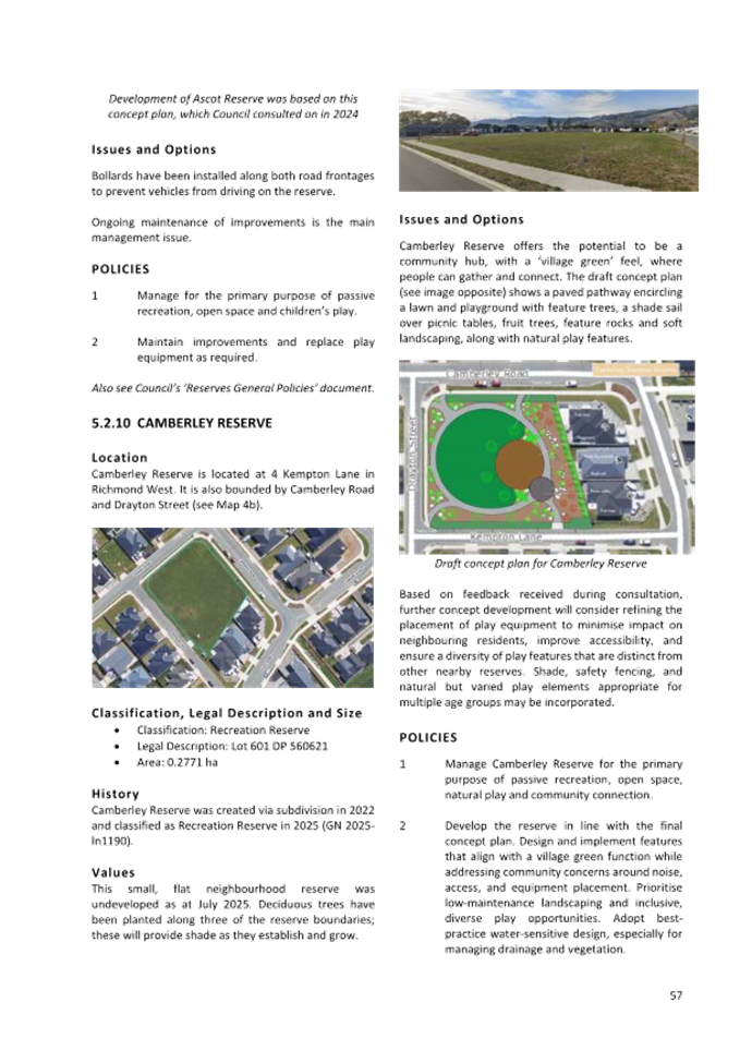
5.2.2 Section 5.2.6 ‘Rosales Park’ has been
amended to include the final concept design and update the description of this
within the Values subsection.
5.2.3 Written descriptions of concept
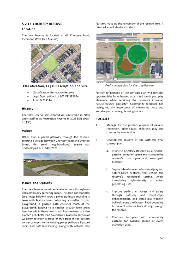
plans and policies for Camberley Reserve (section 5.2.10), Lampton Reserve
(section 5.2.11), and Chertsey Reserve (section 5.2.12) have been refined to
address community feedback, including changes to improve accessibility, respond
to concerns about play equipment placement and noise, and maintain the informal
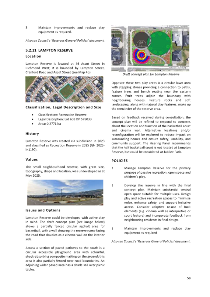
or low-impact character of certain reserves. The Hearing Panel recommended, for
example, that the proposed half basketball court not be constructed at Lampton
Reserve but could be considered at Jubilee Park.
5.2.4 Section 5.2.15 ‘Pukeko Park’ has been
amended to initiate a renaming process in partnership with iwi, based on
community support for a name that reflects local identity and values. Policies
now support collaborative naming and development of interpretive signage.
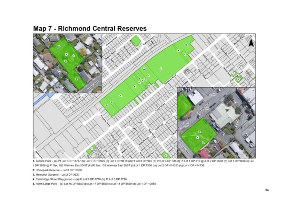
5.2.5 Amendments to Jubilee Park (section 5.2.17) and
Cambridge Street Playground (section 5.2.20) reflect submitter support for
additional on-site parking, retention and upgrade of the skatepark, a potential
half basketball court, and formal protection of both sites under the Reserves
Act 1977. Policies have been amended or added accordingly.
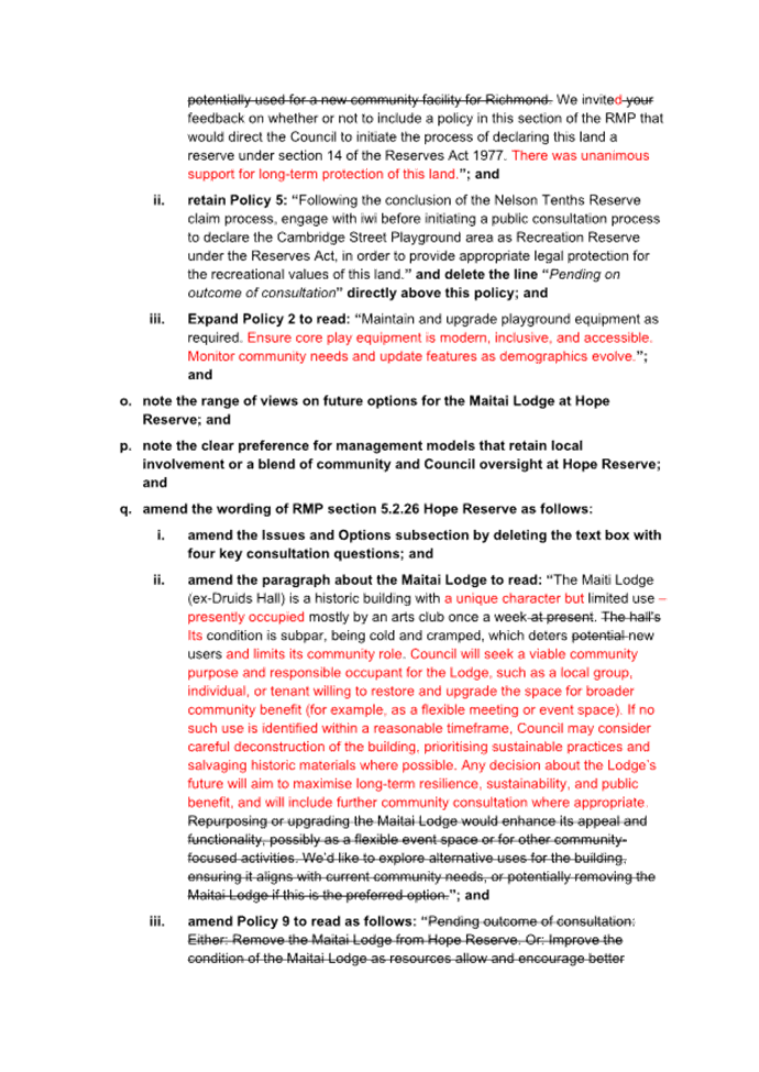
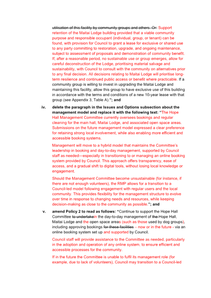
5.2.6 Section 5.2.26 ‘Hope
Reserve’ has been substantially revised to address the future use of the
Maitai Lodge building and outline a hybrid management model. Amendments reflect
a desire to retain local involvement while transitioning to more accessible
booking systems, and to explore adaptive reuse and lease of the Lodge or
deconstruction of the building if no sustainable use is found.
5.2.7 The Issues & Options and
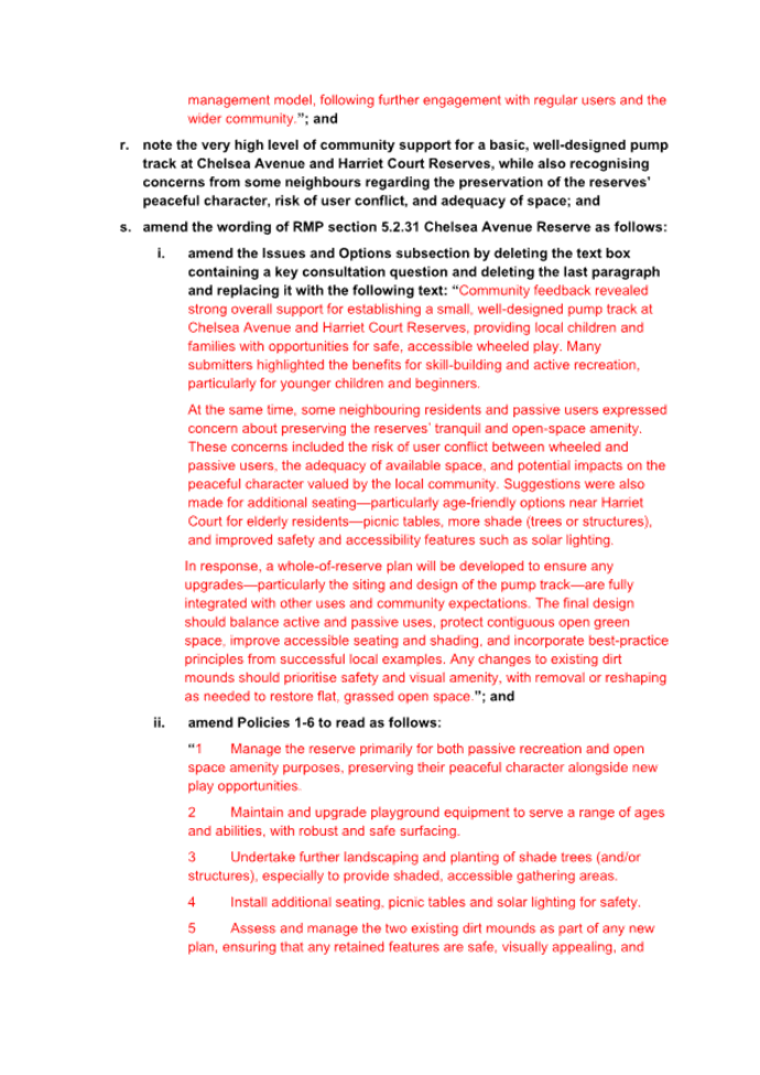
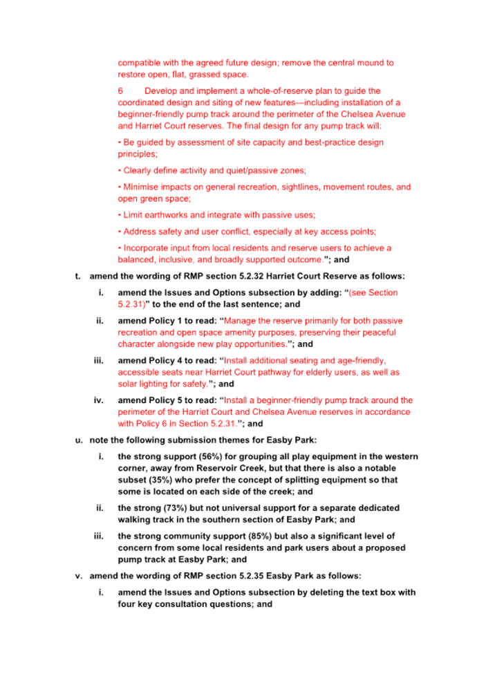
policies subsections for Chelsea Avenue (section 5.2.31) and Harriet Court
(section 5.2.32) reserves have been amended to support the installation of a
beginner-friendly pump track. A whole-of-reserve planning approach will be used
to ensure upgrades are integrated with existing uses, maintain open green
space, and minimise impacts on the peaceful character of the reserves.
Additional seating, shade, and safety features will also be considered.
5.2.8 Section 5.2.35 ‘Easby
Park’ has been amended to consolidate play equipment in the park’s
western corner, improve separation of pedestrian and cycling traffic, and allow
for installation of a modest pump track in the southern area. Several policies
were amended or added to address flood resilience, heritage play features, and
coordination with stormwater projects.
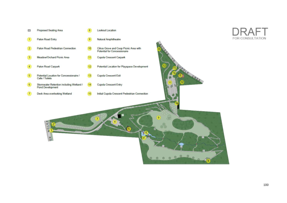
5.2.9 Section 5.2.37 ‘Paton
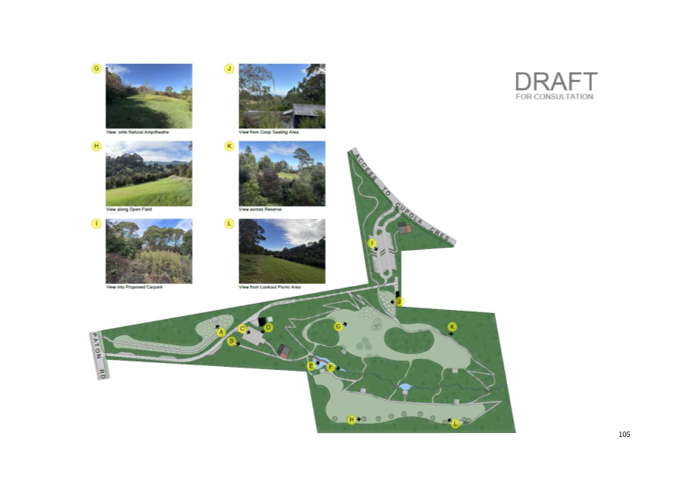
Reserve’ has been amended to reflect feedback on the draft concept plan
and clarify that future development will occur in a phased manner. The policies
for this reserve were extensively rewritten to align with the preferred
approach outlined in submissions.
Additional amendments based on feedback received on other
aspects of the Draft Plan
5.3 Further
refinements have been made to the Plan to strengthen commitments across a range
of management themes, and to enhance clarity, practicality, and alignment with
iwi, community, and stakeholder expectations. These additional edits address:
5.3.1 Part 1, Key Outcomes Sought: Expanded the
‘Environmental Outcomes’ subsection by adding this paragraph:
“Biodiversity protection and ecological connectivity are
paramount across Richmond Ward reserves of all sizes. Each reserve contributes
uniquely to the network of habitats providing for native species and ecosystem
functions. Management reflects an unequivocal commitment to safeguarding and
restoring ecological values everywhere reserve land exists.”
5.3.2 Part
1, Legislative Context: Added a new section 1.4 ‘National Policy
Statement for Indigenous Biodiversity (NPS-IB)’ to note that the Plan
will give effect to the NPS-IB.
5.3.3 Part
3, Te Ao Māori Worldview (Section 1.1): Included an additional policy:
“Encourage use of mātauranga Māori frameworks and narratives in
educational materials for reserves to foster a deeper public understanding of
place and whakapapa connections.”
5.3.4 Part
3, Overview of the Ecology (Section 1.2): An additional objective was added to
prioritise the protection, enhancement, and restoration of indigenous
biodiversity and ecological connectivity throughout the Richmond Ward reserves
network, including smaller and less prominent reserves. Five supporting
policies were introduced to recognise all reserves as important for
biodiversity, promote comprehensive protection and restoration efforts, enhance
habitat connectivity, prevent activities that fragment or degrade ecological
values, and foster collaborative ecological monitoring with iwi and community
groups.
5.3.5 Part
3, Naming of Parks and Reserves (Section 2.3): Expanded the Issues &
Opportunities section to add: “Council acknowledges that the naming and
interpretation of parks and reserves is a continuing, evolving process that
must be sensitive to tikanga Māori and respond to iwi aspirations.”
5.3.6 Part
3, Visitor Use & Management (Section 3.1): Expanded the Issues &
Opportunities section by:
i. Adding a
subsection on ‘Dog exercise and recreation areas’ to more
comprehensively recognise dog walking as a valued recreational activity, while
clearly integrating references to the Council’s Dog Control Bylaw. The
revised text emphasises the provision of designated off-leash areas away from
ecologically sensitive zones alongside the importance of clear signage and
ongoing public education to encourage responsible dog ownership.
ii. Expanding
the subsection on ‘Amenities, accessibility and accommodating a growing
and aging population’ to emphasise the incremental enhancement of
accessible and age-friendly amenities—including toilets, shelters, picnic
areas, rubbish facilities, and wayfinding signage—across not only major
parks but also well-used neighbourhood reserves and urban greenways. Wayfinding
improvements include bilingual signage (English and te reo Māori),
universally accessible fonts and symbols, and interpretive materials promoting
ecological and cultural values.
5.3.7 Visitor
Use & Management (Section 3.1): Nine new policies have been added. The
new policy text gives effect to 5.2.11.1 (ii) and encourages investment in
placemaking and programmed community activities in underused smaller parks to
strengthen local identity, reduce anti-social behaviour, and increase community
pride. The potential for edible landscapes and inclusive, universally
accessible design features that align with ecological and cultural goals is
actively promoted.
5.3.8 Community
Engagement (Section 3.3.): This new section has been added under
“3.0 Recreational Use of Parks and Reserves” to expressly promote
and support active community stewardship across the Richmond Ward reserve
network. This includes encouragement of “friends of” groups, school
partnerships, and volunteer restoration and maintenance events—especially
focused on smaller and less-developed reserves. Policies now suggest
consideration of volunteer training, materials, and ongoing support, supporting
sustainable community involvement in reserve care.
5.3.9 Coastal
Reserves (Section 5.1): A new objective has been added to
explicitly prioritise protection and enhancement of the ecological integrity of
reserves adjoining the Waimea/Waimeha Inlet and other estuarine/saltmarsh
margins, with an emphasis on native biodiversity and ecosystem resilience. Four
new policies (9–12) have been introduced to establish and maintain
eco-sourced buffer planting along these sensitive margins, prioritise habitat
protection including restoration of degraded areas, and implement pathway and
fencing controls to minimise disturbance to vulnerable wildlife, especially
during critical seasonal periods. Additionally, targeted education and
interpretation initiatives have been added to raise public awareness about the
ecological values and promote responsible visitor behaviour. Policy 6 has been
rewritten to strengthen adaptive dog control measures through the
Council’s five-yearly Dog Control Bylaw review process, ensuring
consideration of dog prohibitions or restrictions on all coastal reserves
adjoining the Inlet. This revision specifically ties access control to
ecological monitoring, seasonal wildlife needs, and stakeholder feedback, while
committing to clear public communication to support the protection of
vulnerable species and community compliance.
5.3.10 Overview
and Policies for Local Purpose (Esplanade) Reserves and Local Purpose
(Esplanade & Utility) Reserves in Richmond Ward (Section 5.3.1): Policy 4
has been expanded to require utilisation of eco-sourced native species for
revegetation and restoration plantings, and a new policy has been added
recommending use of nature-based solutions for stormwater management, such as
constructed wetlands, riparian buffers and biofiltration, where practical.
5.4 These
additional edits reinforce the RMP’s holistic approach to ecological
protection, cultural partnership, active and inclusive recreation, and
community partnerships, reflecting both the Hearing Panel’s recommendations
and detailed stakeholder advice received during the final stages of plan
development.
6. Financial
or Budgetary Implications / Ngā Ritenga ā-Pūtea
6.1 The Council has provided the budget for
preparation of the Richmond Ward Reserve Management Plan in its Long Term Plan
2024-2034.
6.2 The costs associated with development of
the Plan have been absorbed within the Service and Strategy Group.
6.3 There will be costs associated with
implementing some of the recommended changes in the final Plan. Provision for
some of these will come from existing reserve budgets, while others will need
to be considered during future Council annual and long term planning processes.
6.4 By adopting the Plan, the Council is not
committing to funding all projects identified, or to fund them by a particular
date. Some of the projects may involve contributions from volunteers
(particularly in terms of time and labour), thereby reducing the financial
costs associated with plan implementation. Where funding is required,
allocation of funds will be subject to the Council’s annual and long term
planning processes – i.e. will be balanced alongside all projects planned
within the District each year.
7.1 At the 29 July 2025 hearing and
deliberations meeting, the Hearing Panel considered all submissions and
feedback received on the Draft Plan. The Panel also formed recommendations on
how the document should be amended in response to submission points that they
accepted in full or in part. The Hearing Panel recommendations are summarised
in section 5 of this report and further details are included within the minutes
of the deliberations meeting.
7.2 The Hearing Panel recommendations of 29
July 2025 have been given effect to in the wording of the amended Plan (see Attachment
2). The Council is being asked to consider the amended document and then
adopt this as the final Richmond Ward Reserve Management Plan.
7.3 The options are outlined in the
following table:
|
Option
|
Advantage
|
Disadvantage
|
|
1.
|
Agree to all the changes recommended by
the Hearing Panel and adopt the amended Plan (see Attachment 2) as the
final Plan.
|
This option shows that submitter views
have been considered by the Hearing Panel and, where appropriate, amendments
have been made to the Plan.
|
Not every submission point has been
accepted. Some submitters may therefore be disappointed that their
suggestions were not given effect to in the amended Plan. However, this is
part of the public submission process, and not all suggestions will be appropriate
or can be adopted.
|
|
2.
|
Agree to some of the changes recommended
by the Hearing Panel, reject other changes and/or make further amendments to
the Plan text before finalising and adopting the Plan.
|
Option 2 has similar advantages to Option
1. An additional advantage is that it would enable the Council to make
amendments to the Plan before it is finalised if not all the Hearing
Panel’s recommendations are accepted.
|
Option 2 has similar disadvantages to
Option 1. Additionally, not all elected members were present to hear
submitter views and were not part of the deliberations.
|
|
3.
|
Adopt the Draft Plan as the final Plan
without amendment, other than the amendments necessary to change the Plan
from a “draft” to a “final” Plan.
|
Limited/no advantages.
|
The Council will be open to criticism for
not listening to the community’s views through the public consultation
process.
|
7.4 Option 1 is recommended.
8.1 The Council has followed the correct
procedure for preparing the Plan, as required under the Reserves Act 1977.
Detailed descriptions of this process, including engagement with iwi and the
initial consultation round undertaken during the summer of 2023/2024, were
included in previous reports on this matter.
9. Iwi
Engagement / Whakawhitiwhiti ā-Hapori Māori
9.1 Iwi actively engaged in the Plan review
throughout the whole process. Two of the five Hearing Panel members were
mātauranga Māori experts nominated by iwi.
10. Significance
and Engagement / Hiranga me te Whakawhitiwhiti ā-Hapori Whānui
10.1 The Richmond Ward Reserve Management Plan is
moderately significant for our community as it impacts on their use and
enjoyment of parks and reserves. The public consultation procedure enabled the
public to provide us with their views about the appropriateness or otherwise of
the Draft Plan. The amendments proposed are in line with submissions made on
the Draft Plan and are not of high significance. Therefore, the Council can
adopt the recommendations of the Hearing Panel without undertaking further
consultation.
|
|
Issue
|
Level of
Significance
|
Explanation of
Assessment
|
|
1.
|
Is there a high level
of public interest, or is decision likely to be controversial?
|
Medium
|
The Plan is of medium
significance to residents and visitors to the Richmond Ward because it sets
policy direction for the use and management of approximately 133 parks and
reserves.
|
|
2.
|
Are there impacts on
the social, economic, environmental or cultural aspects of well-being of the
community in the present or future?
|
Low
|
Implementation of the
Plan will enhance future well-being.
|
|
3.
|
Is there a
significant impact arising from duration of the effects from the decision?
|
Medium
|
The Plan is likely to be in
place for 10 years.
|
|
4.
|
Does the decision
relate to a strategic asset? (refer Significance and Engagement Policy for
list of strategic assets)
|
N/A
|
|
|
5.
|
Does the decision
create a substantial change in the level of service provided by Council?
|
Low
|
The Plan will enhance the levels
of service at a number of parks and reserves, however no major changes are
proposed.
|
|
6.
|
Does the proposal,
activity or decision substantially affect debt, rates or Council finances in
any one year or more of the LTP?
|
Low
|
The Plan outlines several
development plans for specific parks and reserves. However, budget
allocation decisions will be made separately, as part of future annual and
long term plan processes. See paragraph 6.4 above.
|
|
7.
|
Does the decision
involve the sale of a substantial proportion or controlling interest in a CCO
or CCTO?
|
N/A
|
|
|
8.
|
Does the
proposal or decision involve entry into a private sector partnership or
contract to carry out the deliver on any Council group of activities?
|
N/A
|
|
|
9.
|
Does the proposal or
decision involve Council exiting from or entering into a group of
activities?
|
N/A
|
|
|
10.
|
Does the proposal
require particular consideration of the obligations of Te Mana O Te Wai
(TMOTW) relating to freshwater or particular consideration of current
legislation relating to water supply, wastewater and stormwater
infrastructure and services?
|
Low
|
Sections 5.3 to 5.6
of the draft RMP provide management guidance for Local Purpose Reserves of
various types, including many that have a stormwater management function. The
management guidance provided includes reference to TMOTW principles.
|
11. Communication
/ Whakawhitiwhiti Kōrero
11.1 Communication has been covered in previous reports.
Consultation on the Draft Plan was advertised and promoted on the
Council’s website, social media channels, Shape Tasman and Newsline. Iwi,
stakeholders and those who had previously submitted ideas for the Draft Plan
were directly notified via email when the document was publicly notified.
11.2 Once the final document is adopted, staff will
publish the Plan on the Council’s website, update the Shape Tasman project page and
write to all submitters to advise them of the outcome.
12.1 Risks associated with the matters contained in the
Plan have been addressed in previous reports.
13. Climate
Change Considerations / Whakaaro
Whakaaweawe Āhuarangi
13.1 The Plan includes objectives and policies that
align with the Tasman Climate Response and Resilience Strategy and Action Plan
2024-2035.
14. Alignment
with Policy and Strategic Plans / Te Hangai ki ngā aupapa Here me ngā
Mahere Rautaki Tūraru
14.1 In 2013, the Minister of Conservation delegated a
number of responsibilities under the Reserves Act 1977 to local authorities,
including the ability to adopt reserve management plans under section 41 of
that Act.
15. Conclusion
/ Kupu Whakatepe
15.1 The Council has undertaken an extensive public
consultation process, initially seeking ideas for inclusion in the draft
document during the summer of 2023/2024. The Hearing Panel has then heard and
deliberated on written and oral submissions on the drafts that were publicly
notified on 12 May 2025.
15.2 The Hearing Panel recommends that the Council adopt
the amended Plan (Attachment 2), incorporating numerous amendments made
in response to matters raised by submitters.
16. Next
Steps and Timeline / Ngā Mahi Whai Ake
16.1 The
final Richmond Ward Reserve Management Plan will come into effect following
adoption by the Council.
16.2 Staff
will publish the final Plan on the Council’s website and make hard copies
available in our offices and libraries.
16.3 Staff
will also respond to all submitters in writing, advising them of the
Council’s decisions on the matters they raised.
16.4 Staff
will work with iwi, community groups and others to implement the objectives and
policies outlined in the final Plan. The Council will consider budget
requirements for specific projects via annual plan and long term plan
processes.
|
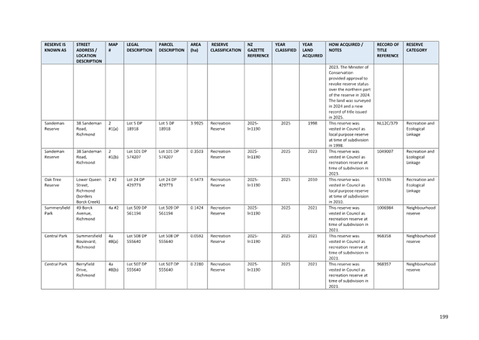
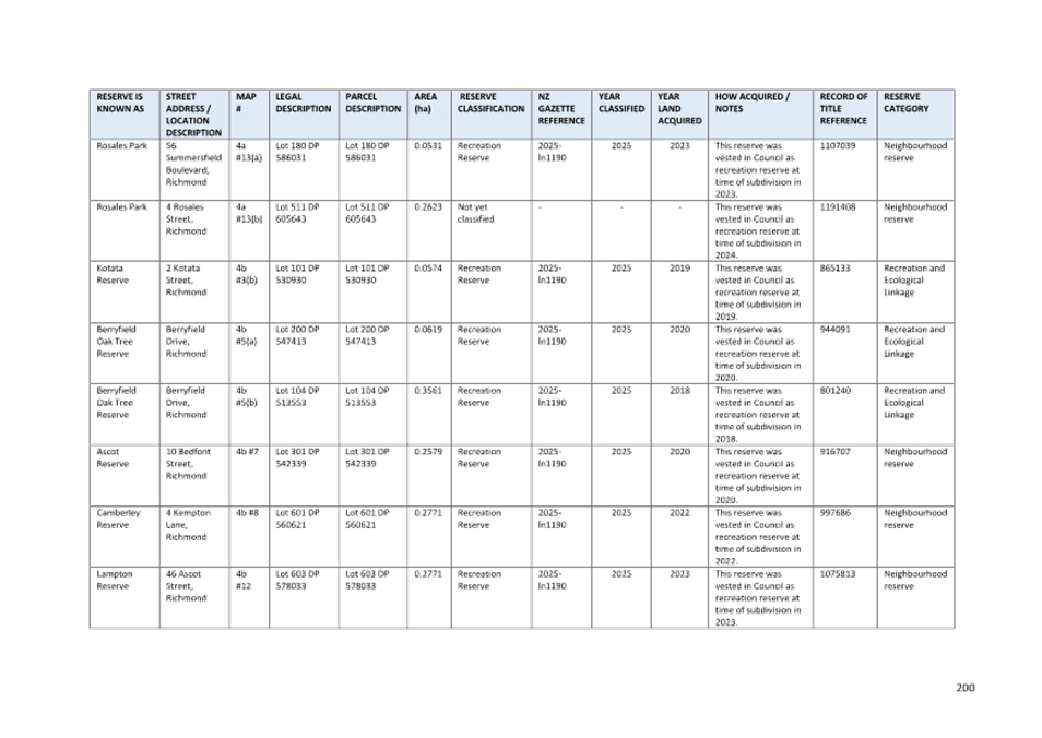
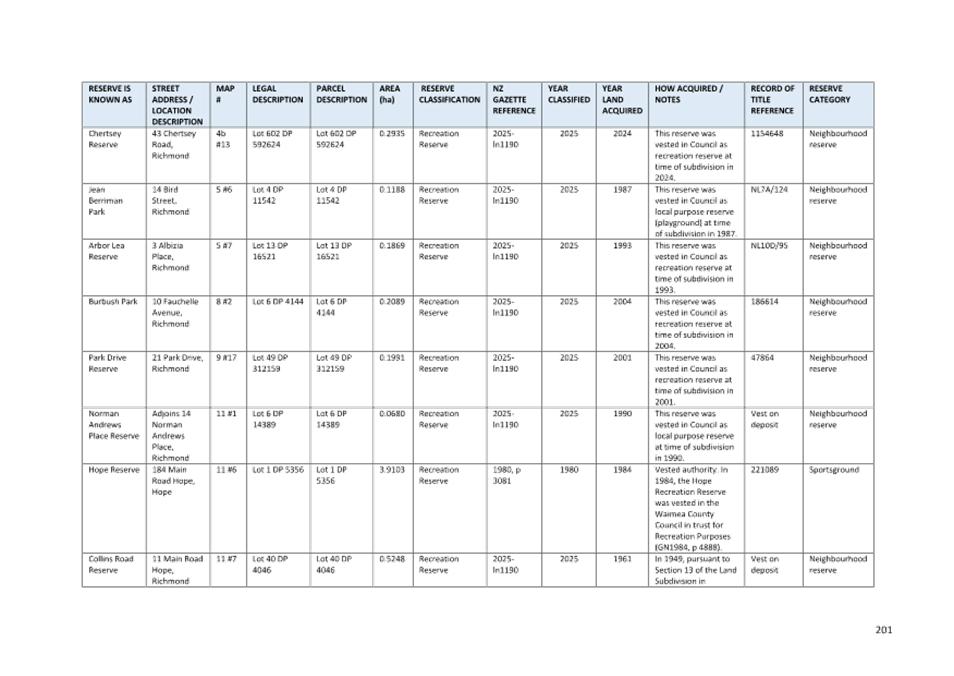
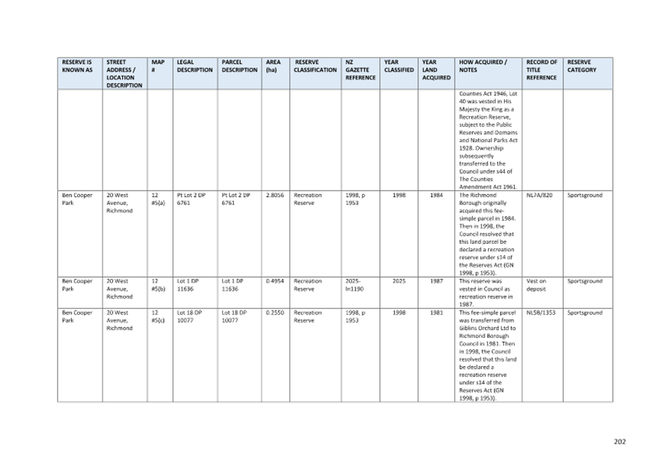
1.⇩
|
Hearing
Panel recommendations for Richmond Ward RMP
|
181
|
|
2.⇩
|
Richmond
Ward RMP (August 2025)
|
199
|
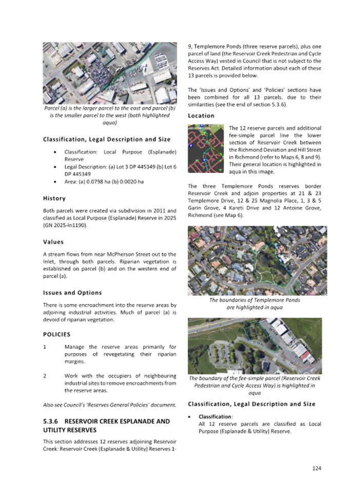
|
3.⇩
|
Statistical
summary of submissions received on the draft Richmond Ward RMP
|
441
|
Tasman District
Council
Agenda – 14 August 2025

Tasman District Council Agenda – 14 August 2025


Tasman District Council Agenda – 14 August 2025
Tasman District Council Agenda – 14 August 2025
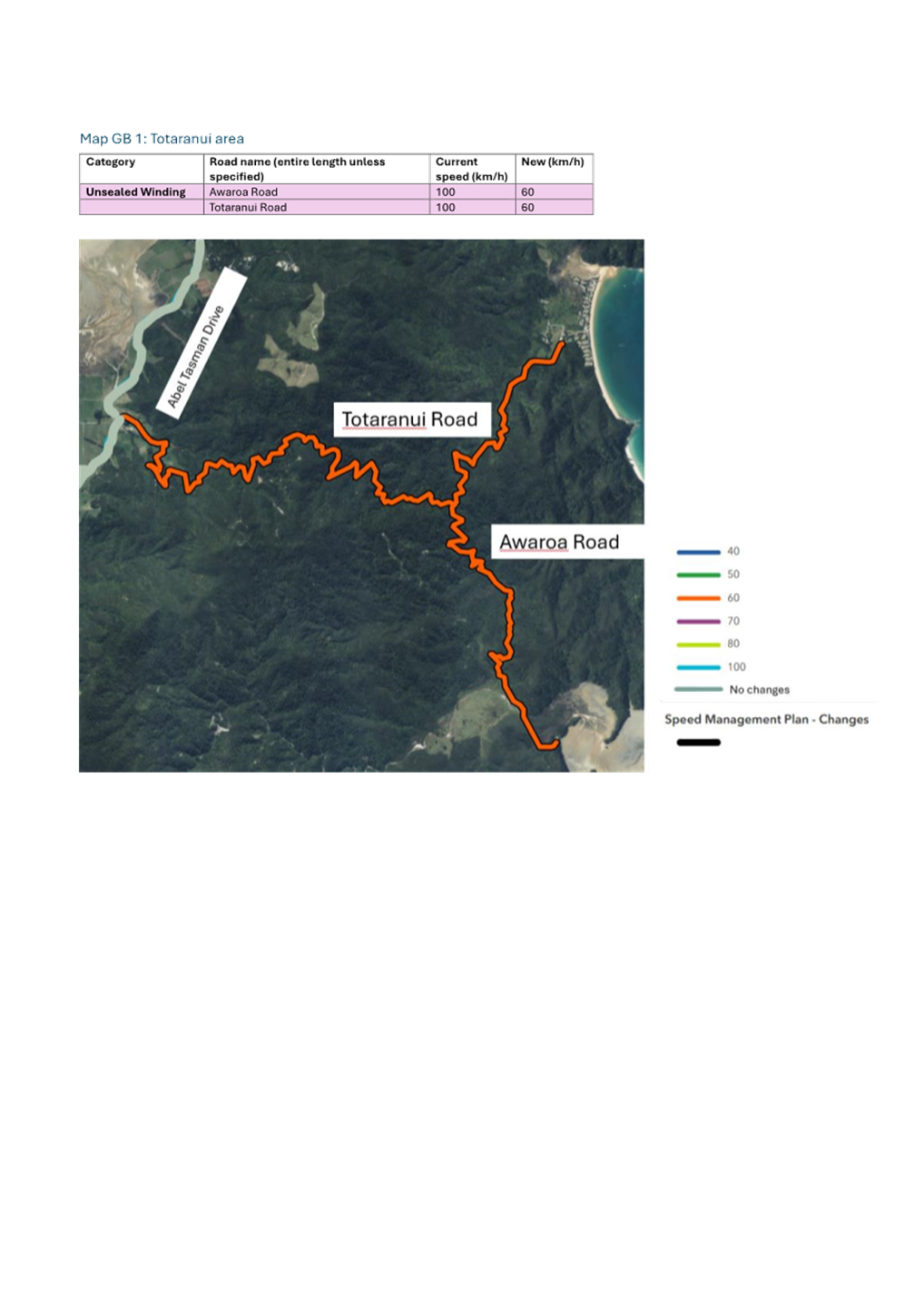
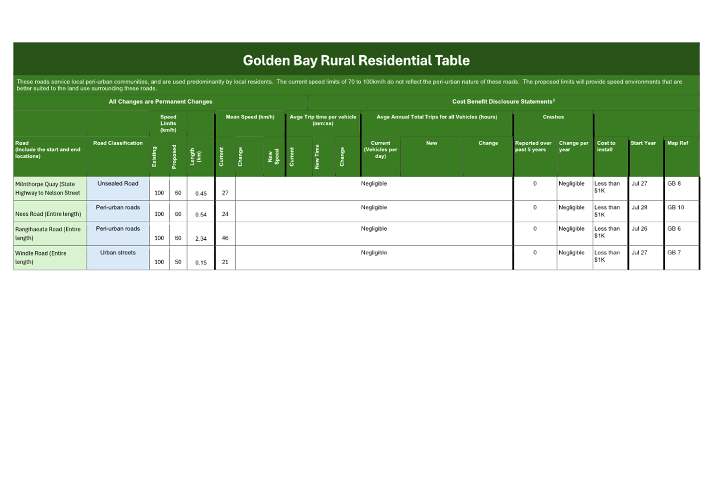
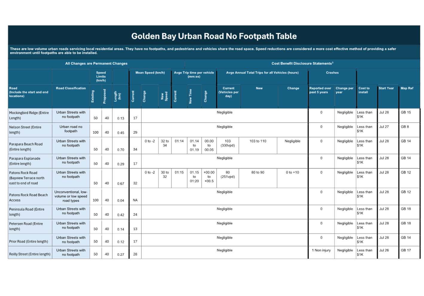
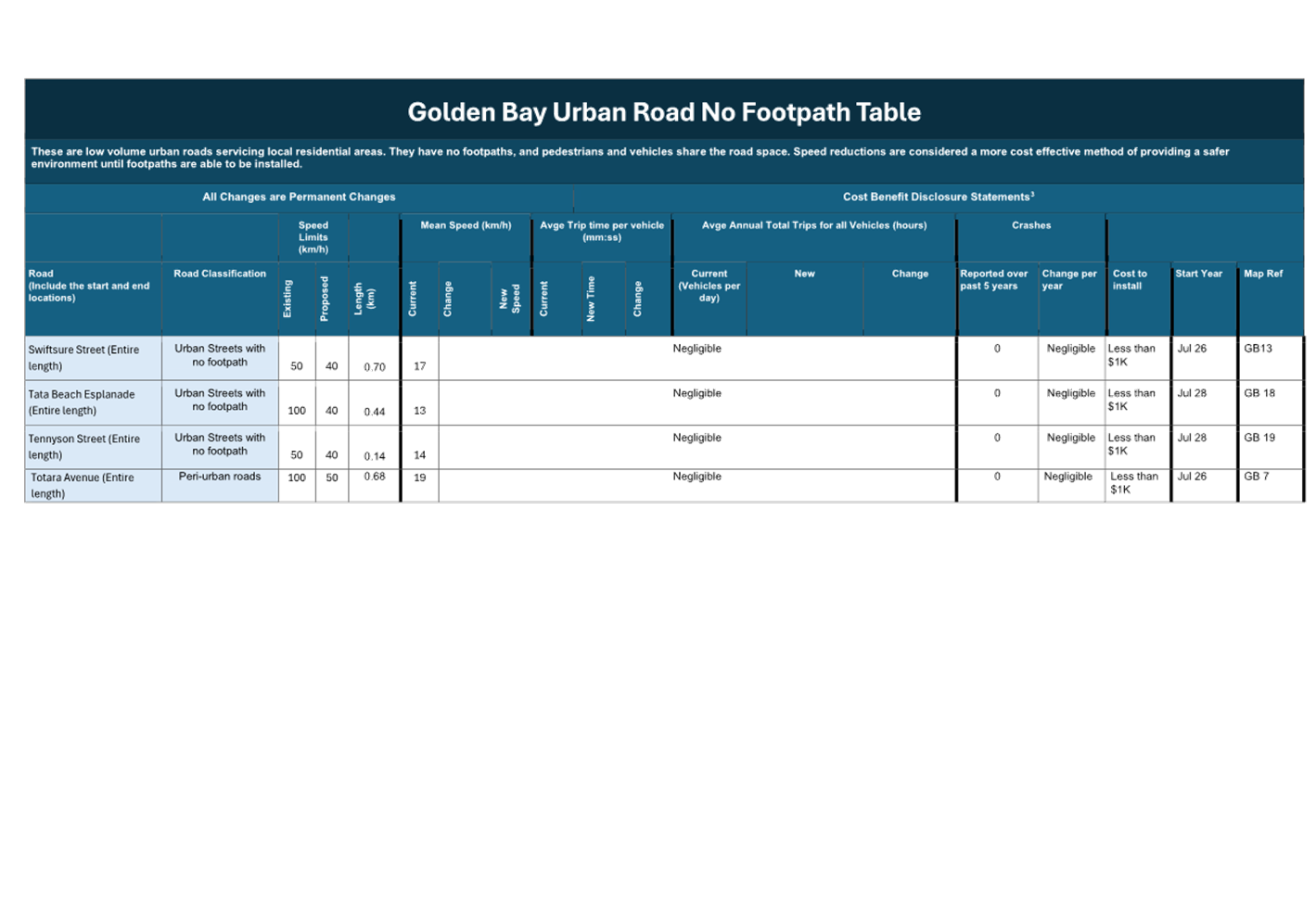
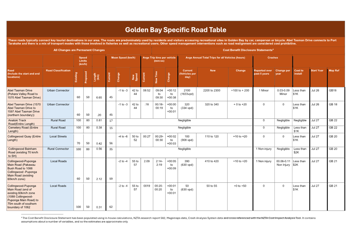
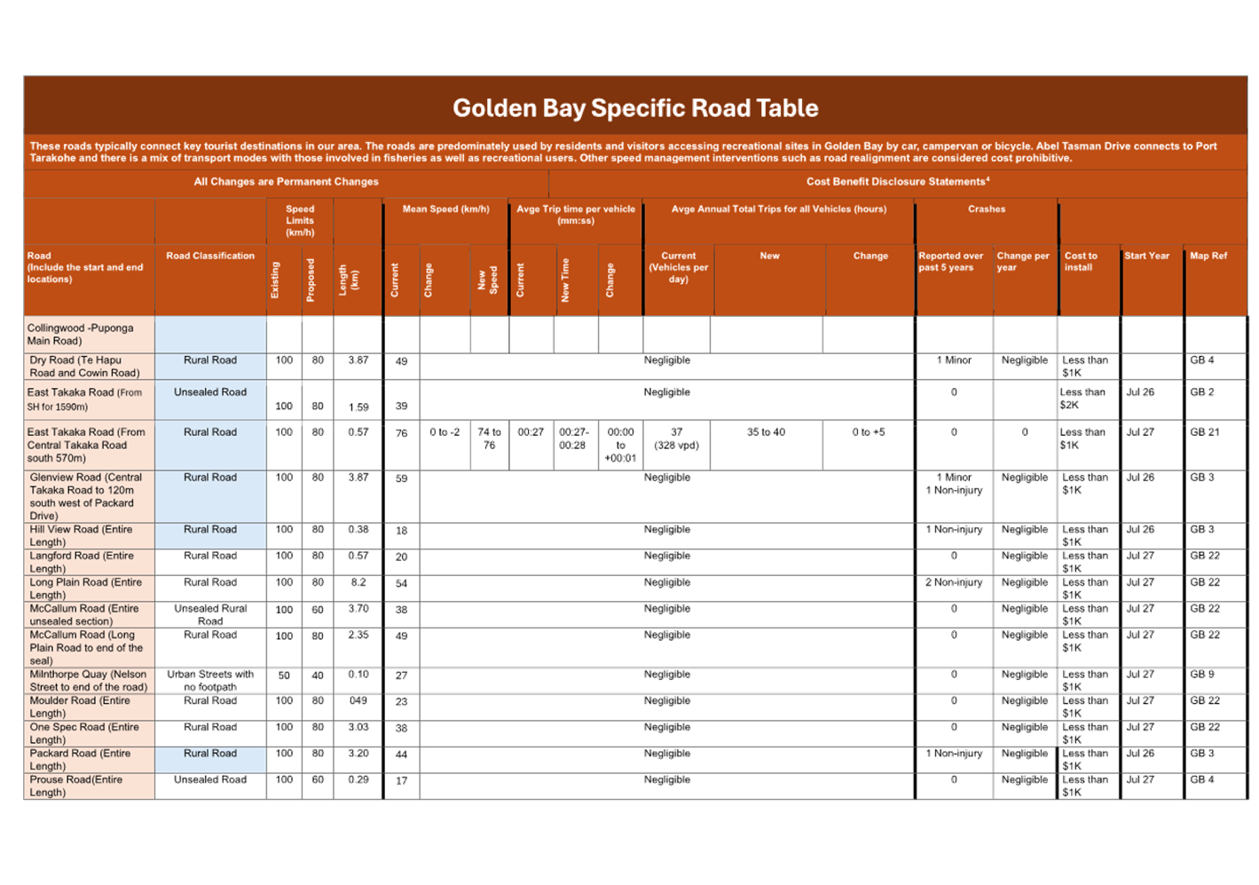
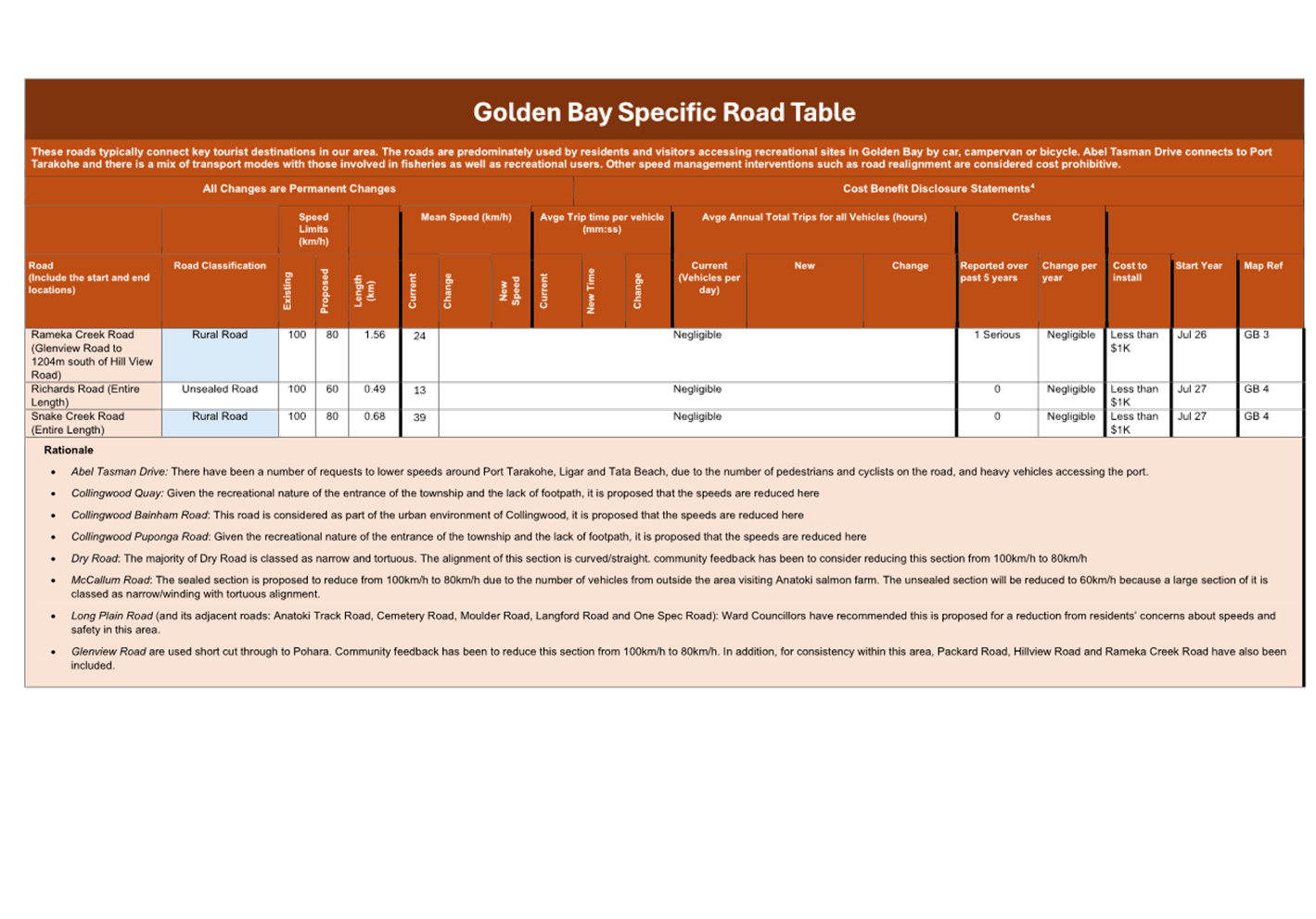
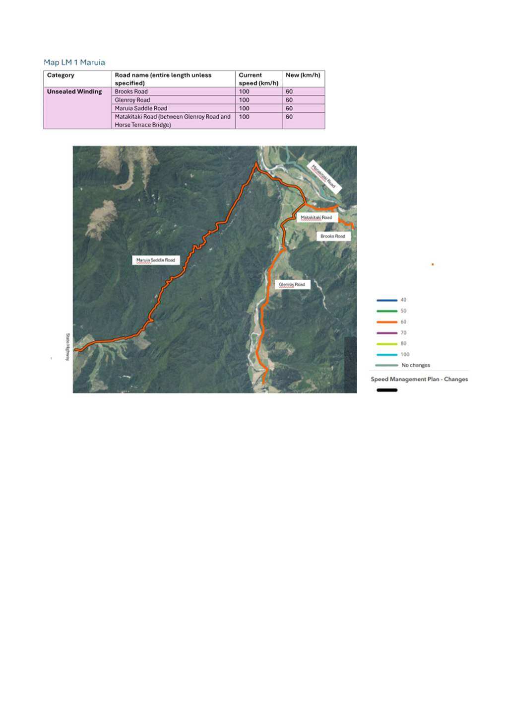
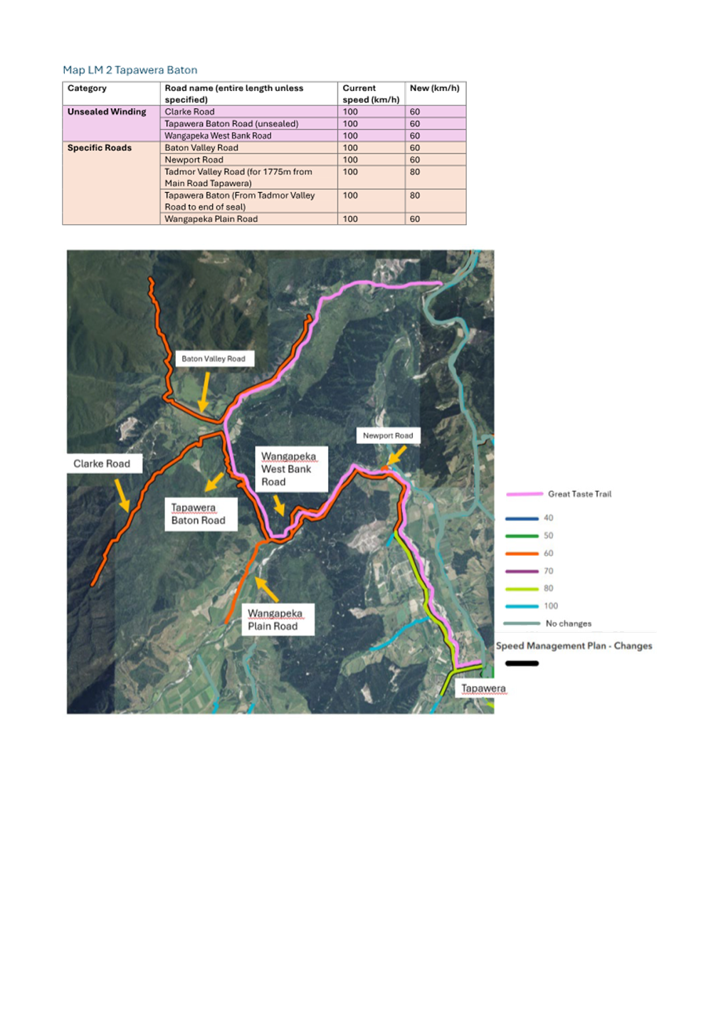
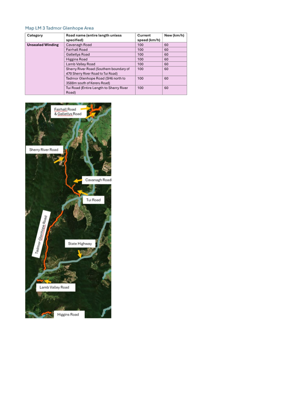
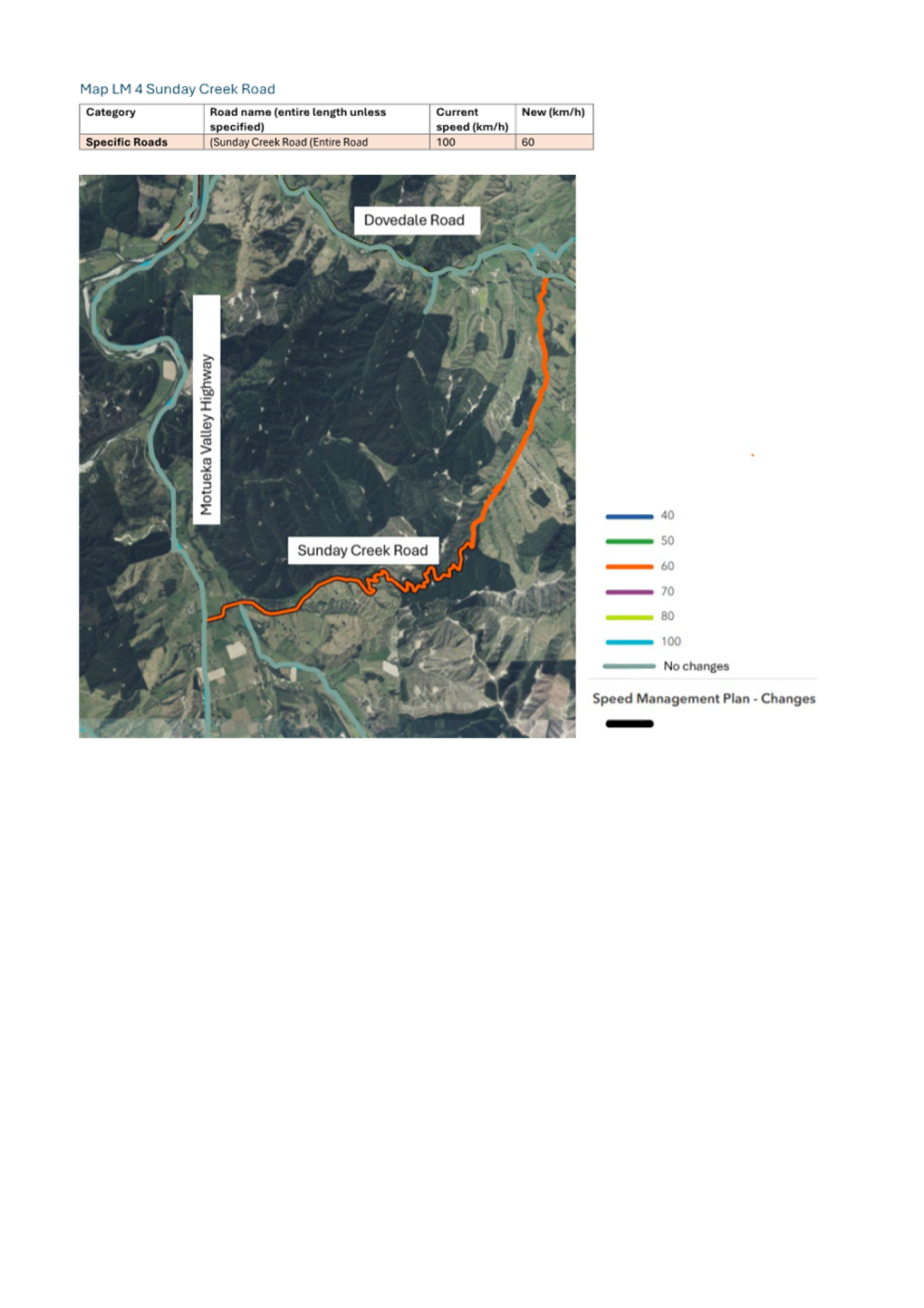
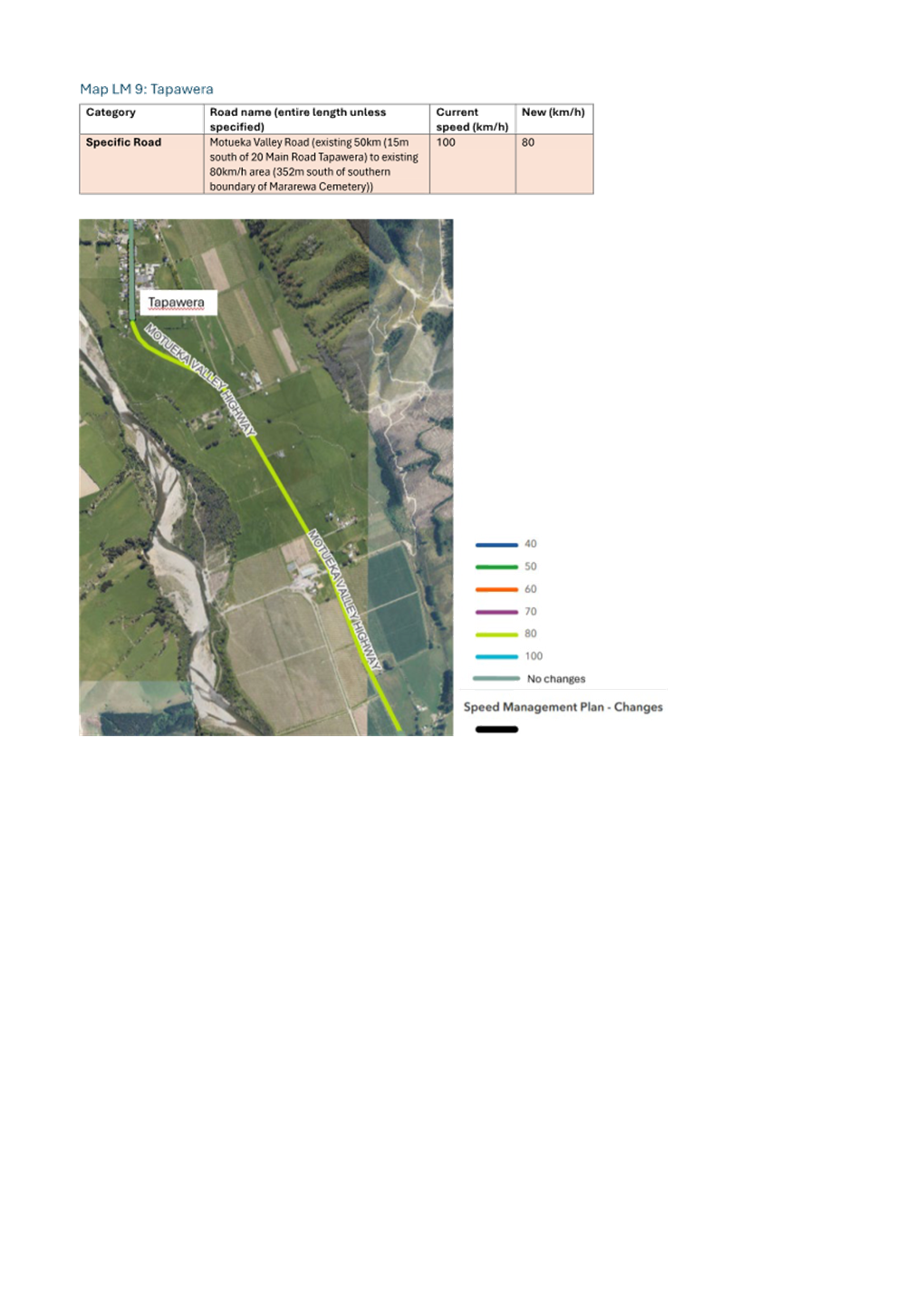
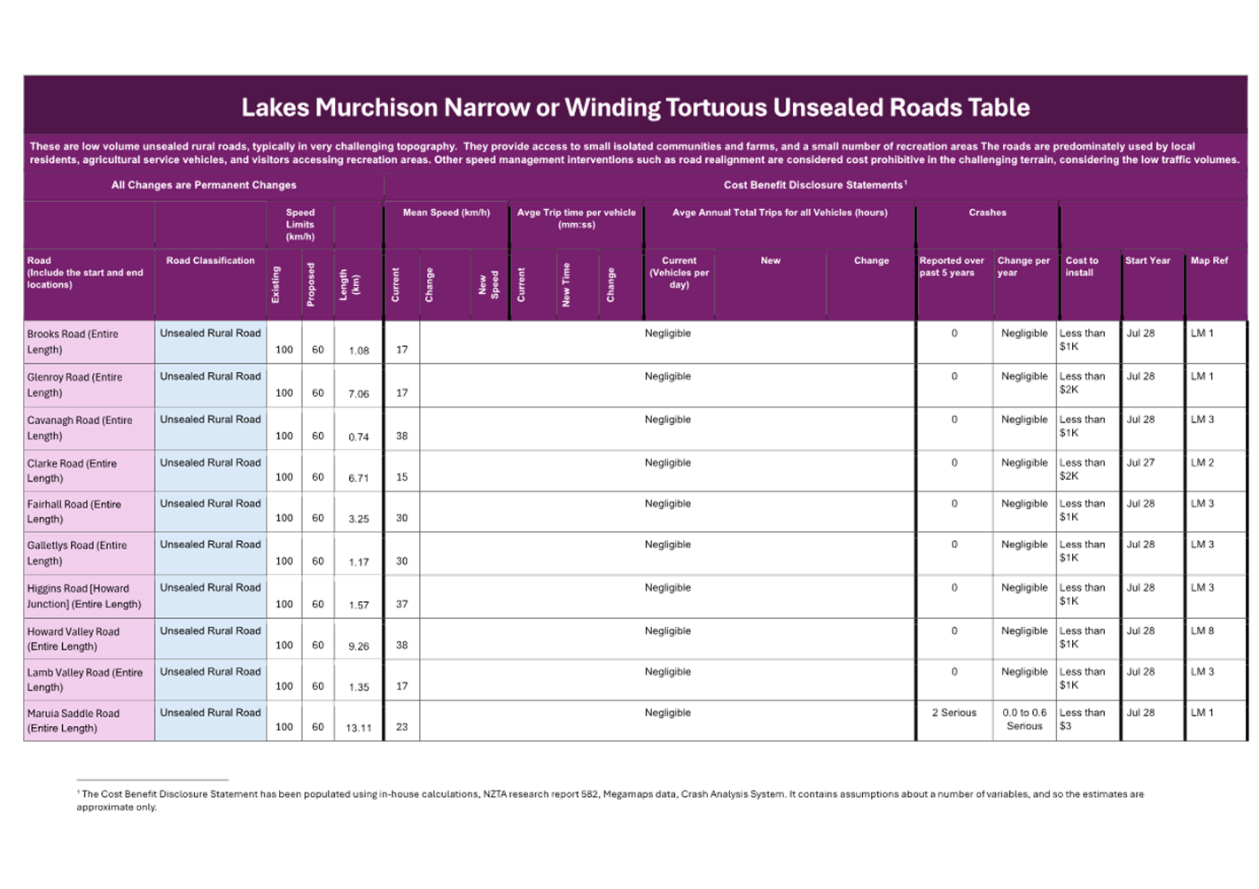
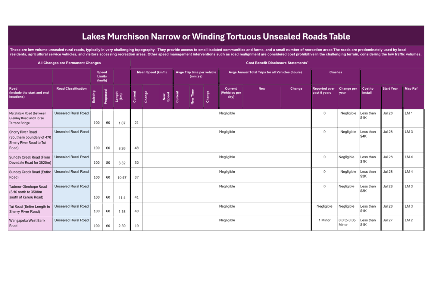
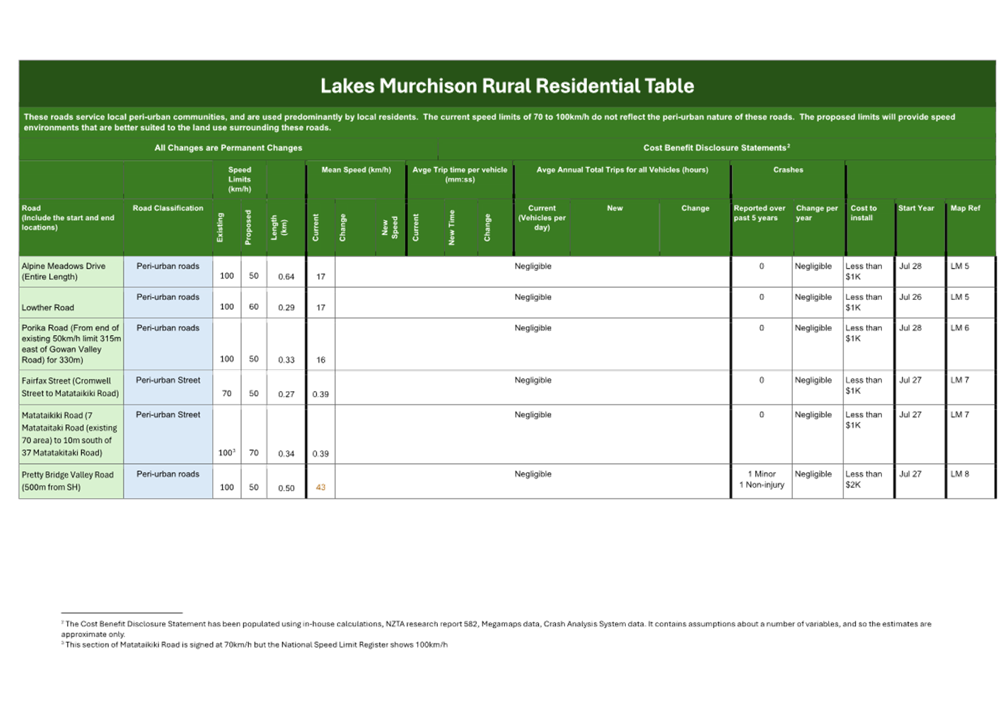
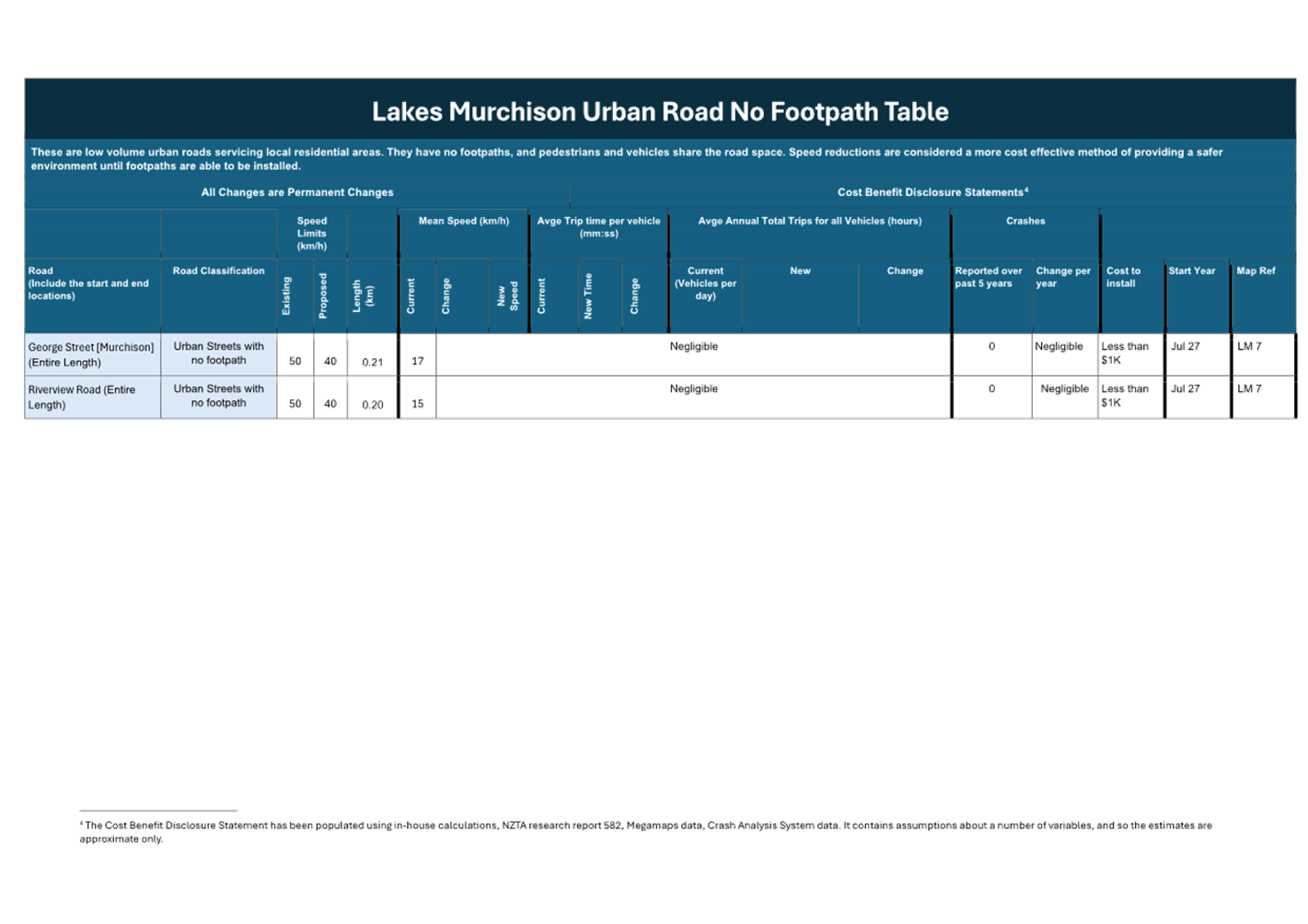
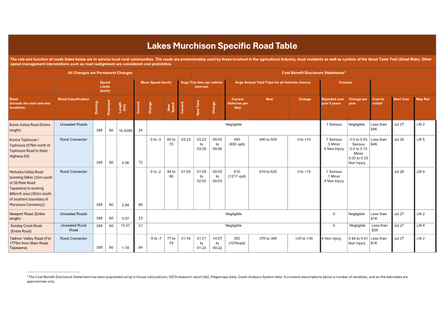
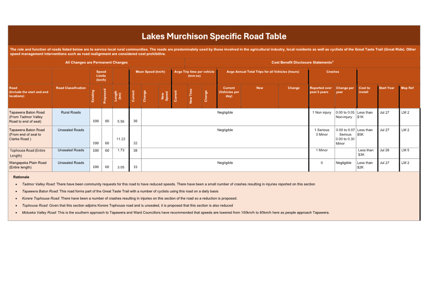
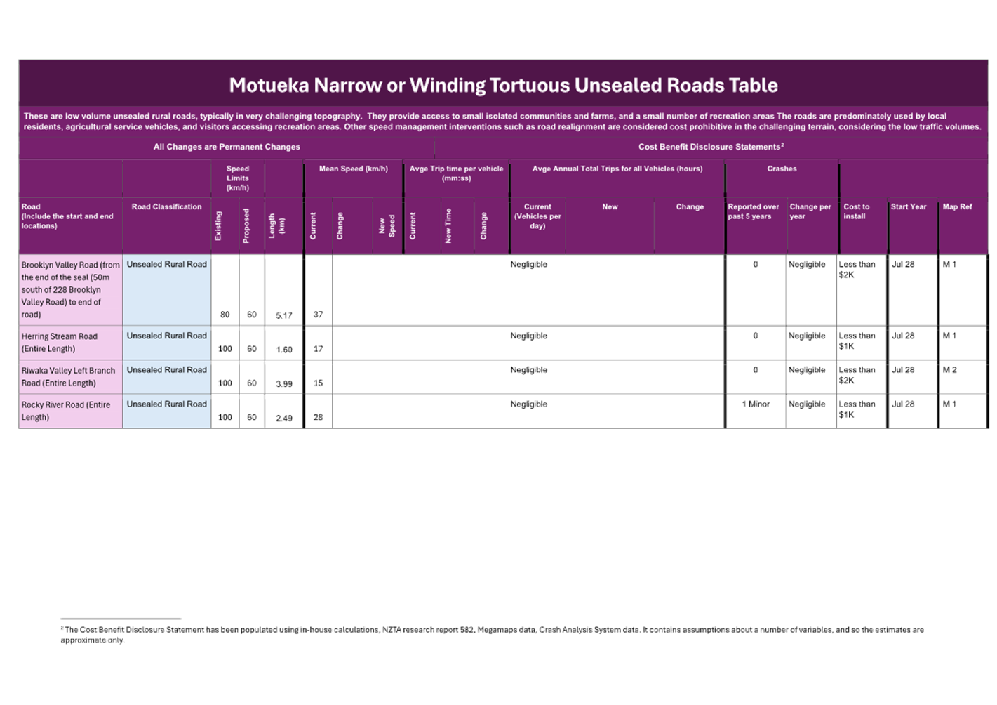
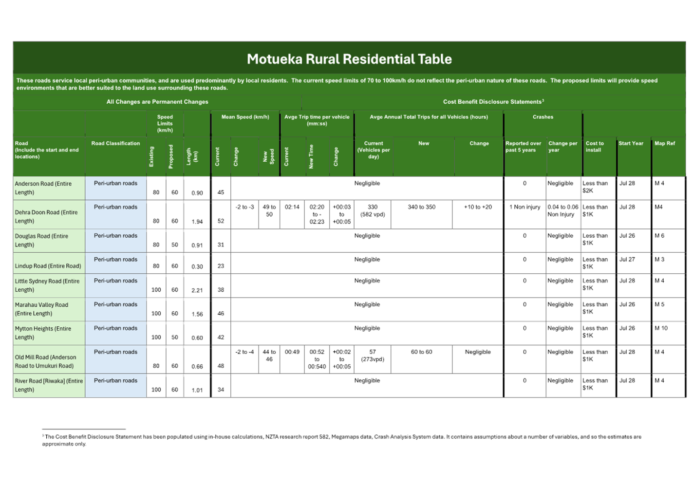
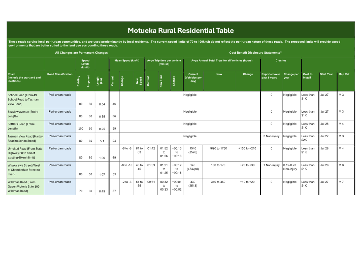
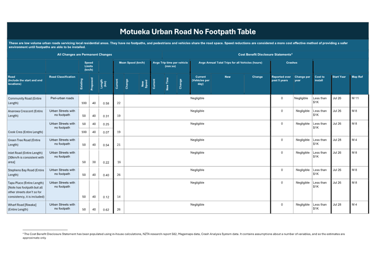
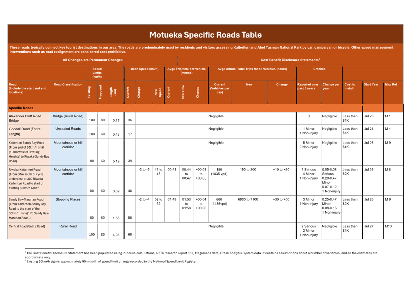
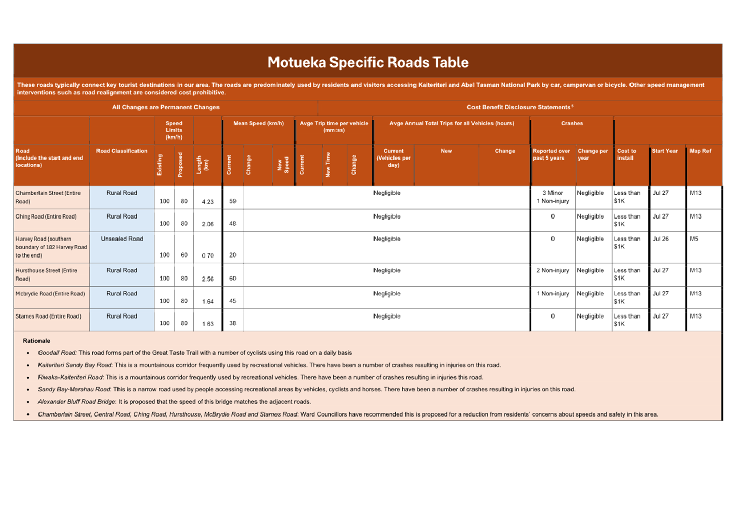
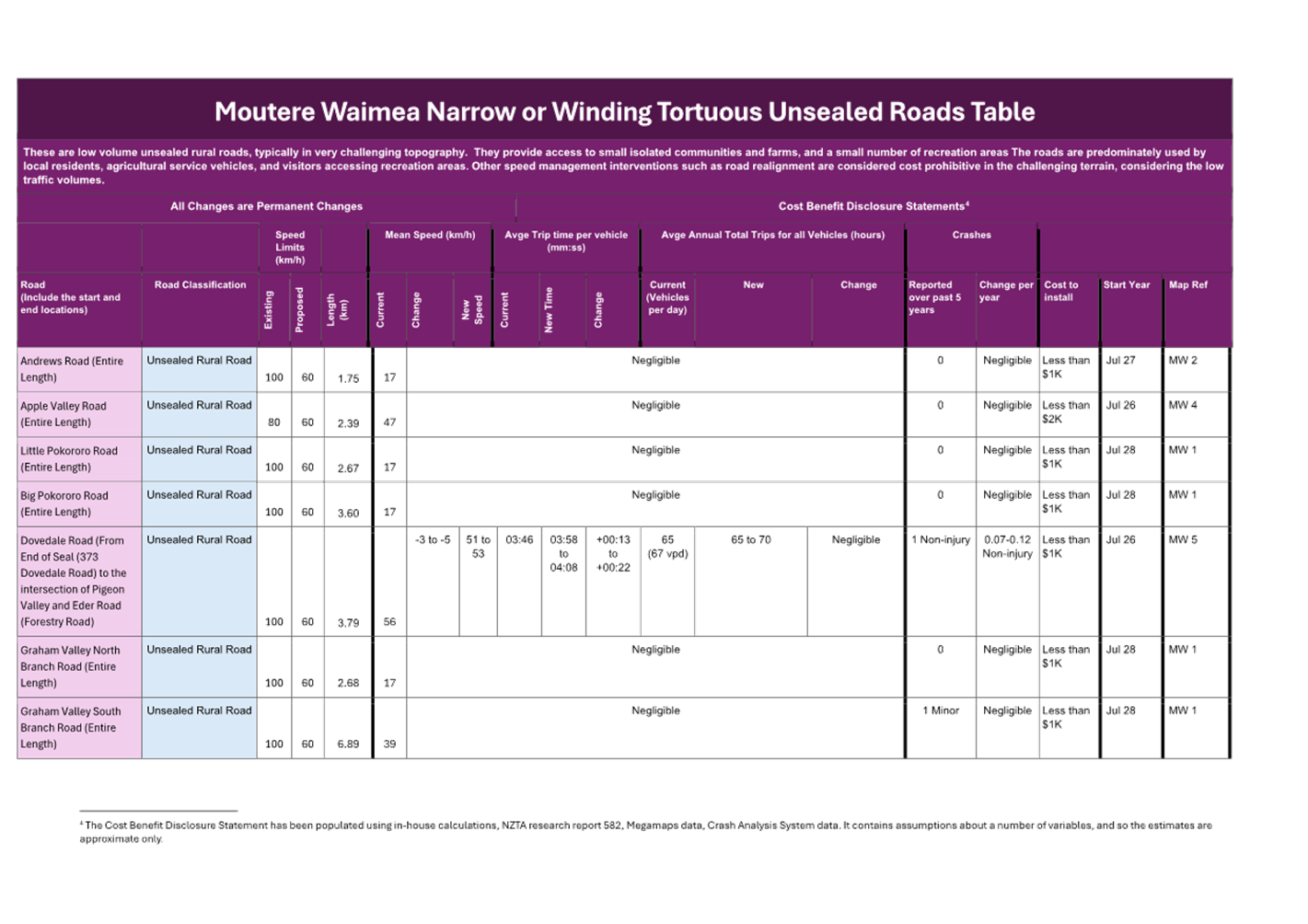
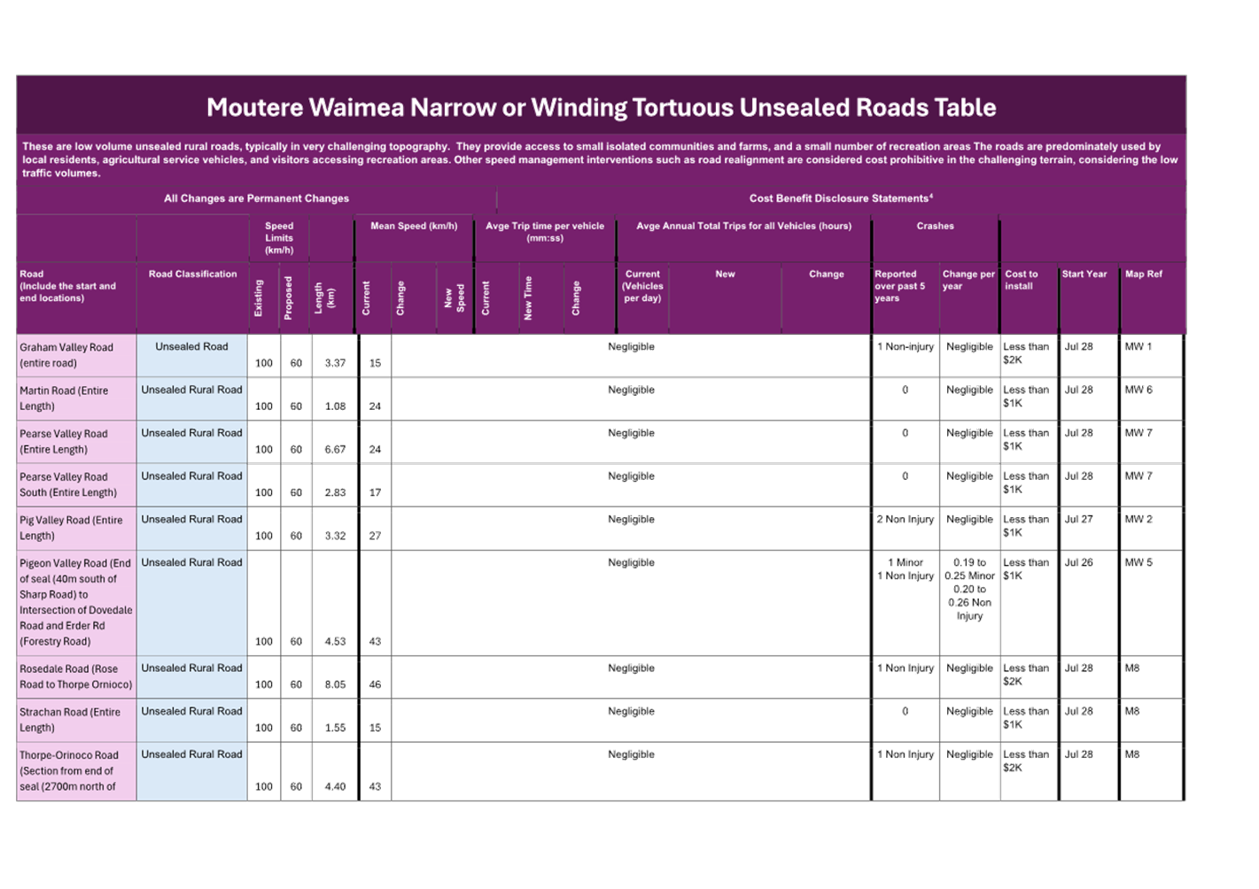
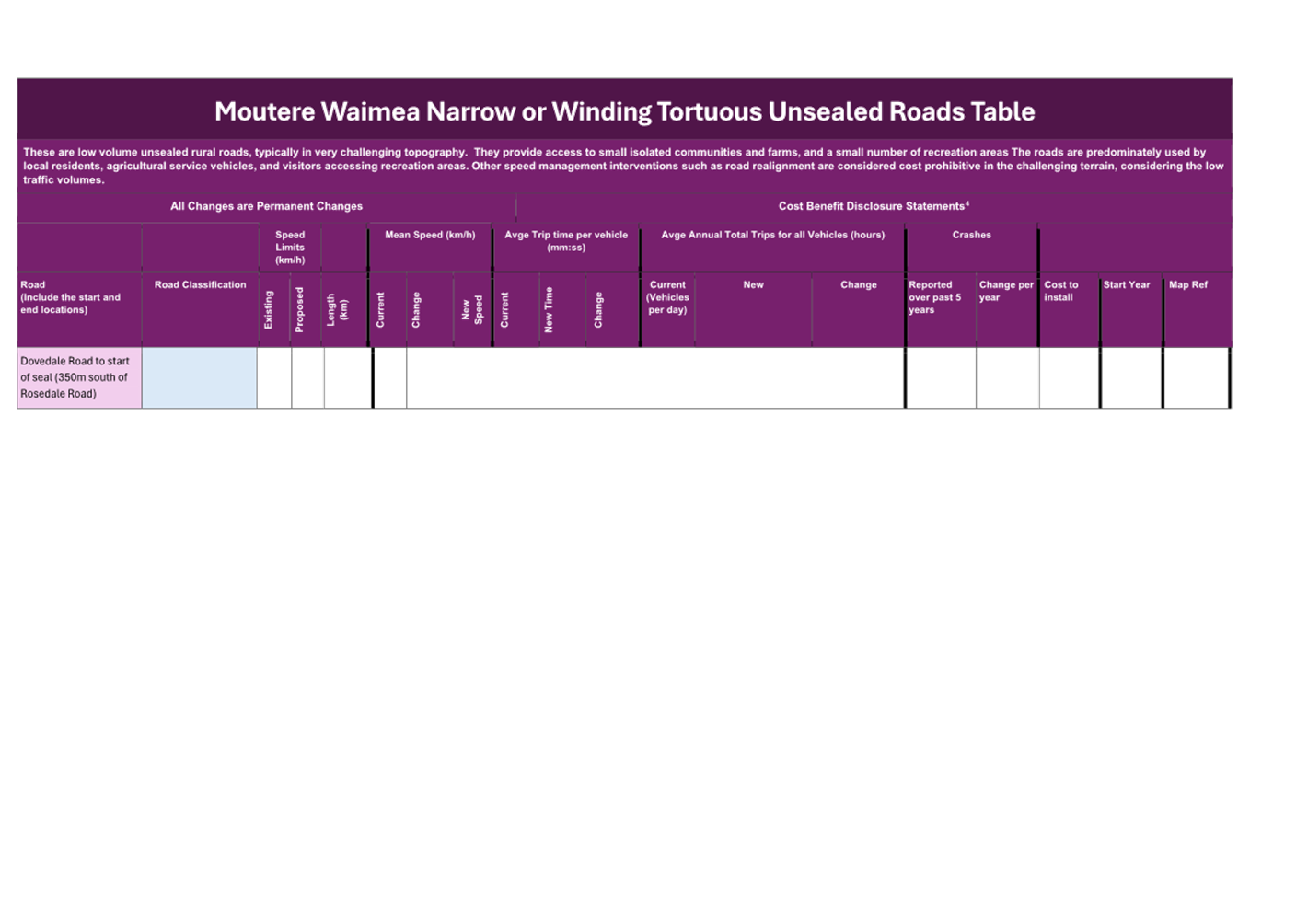
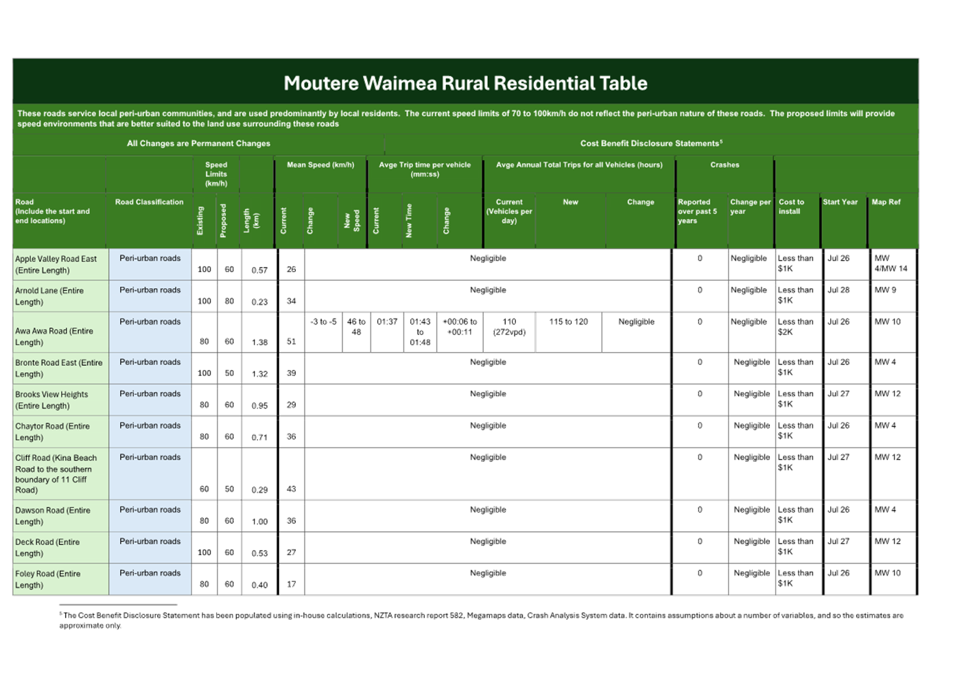
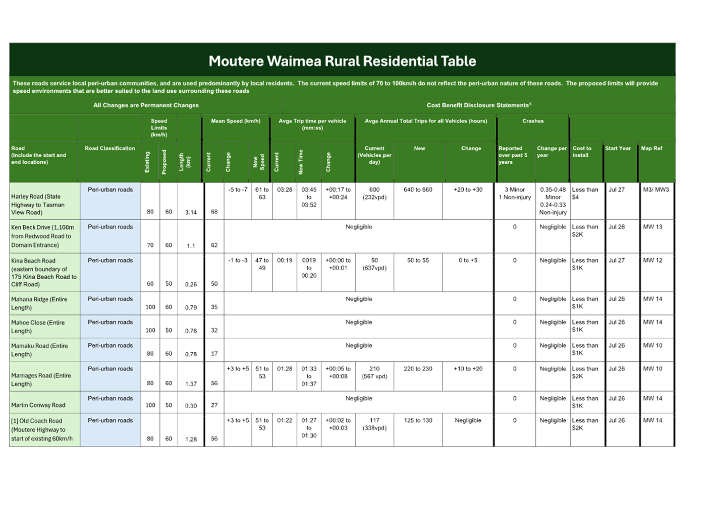
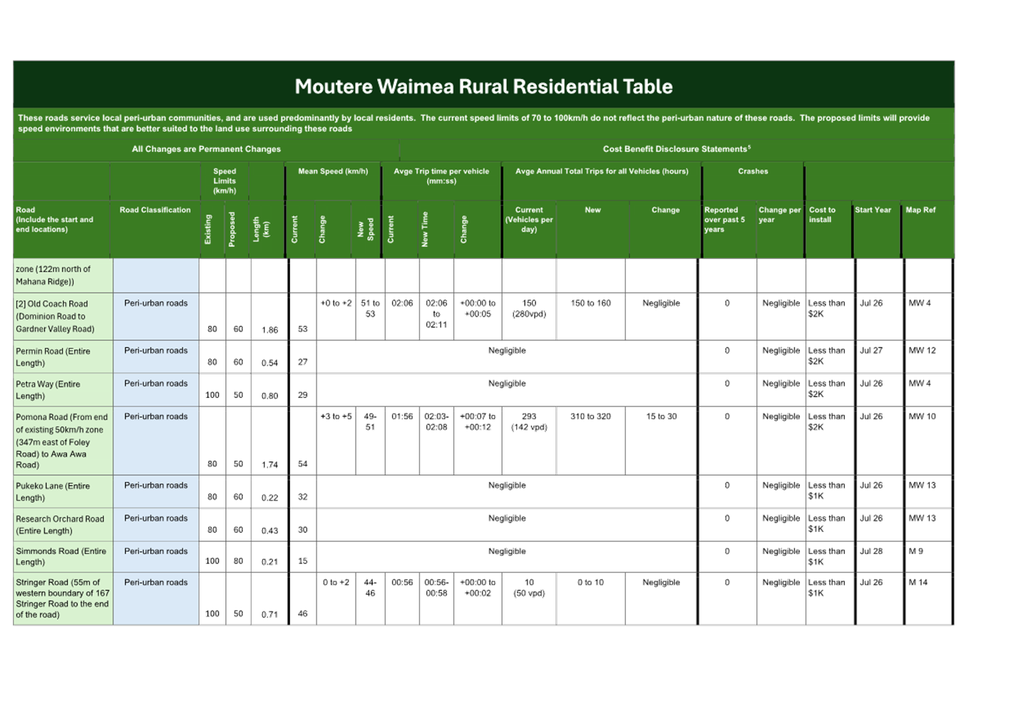
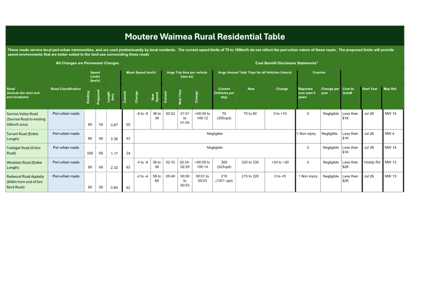
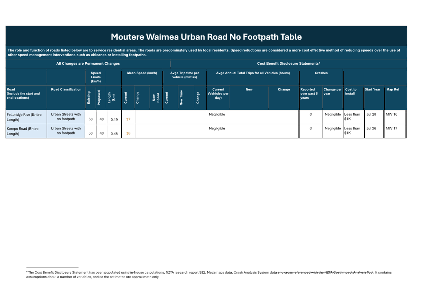
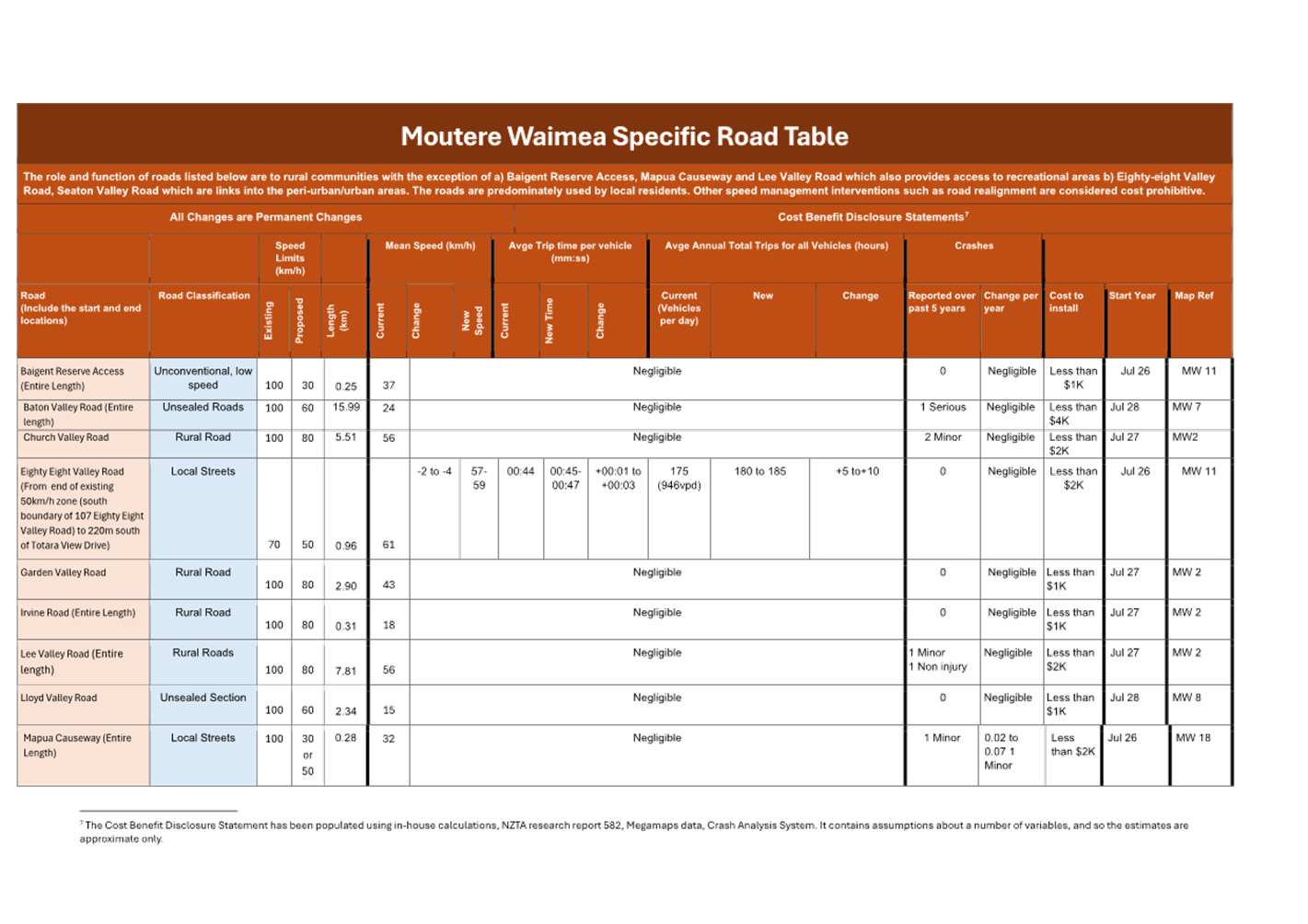
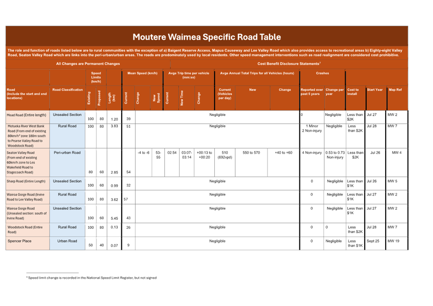
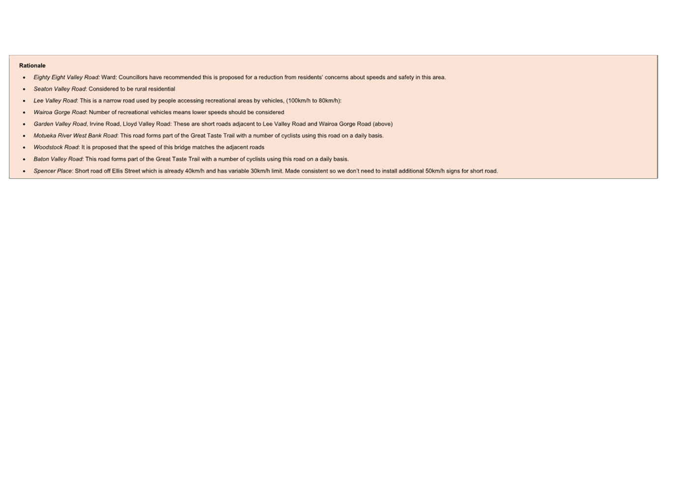
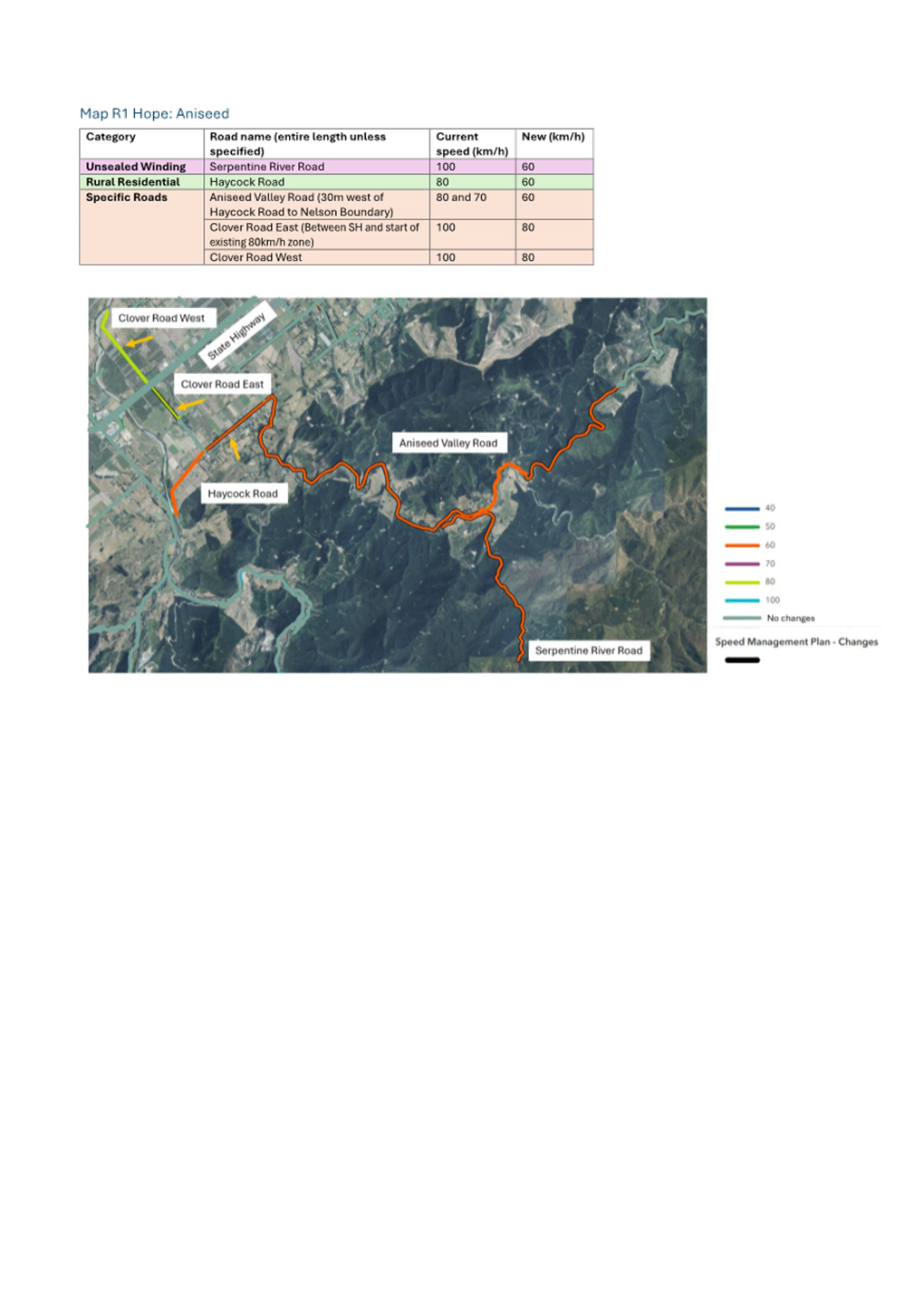
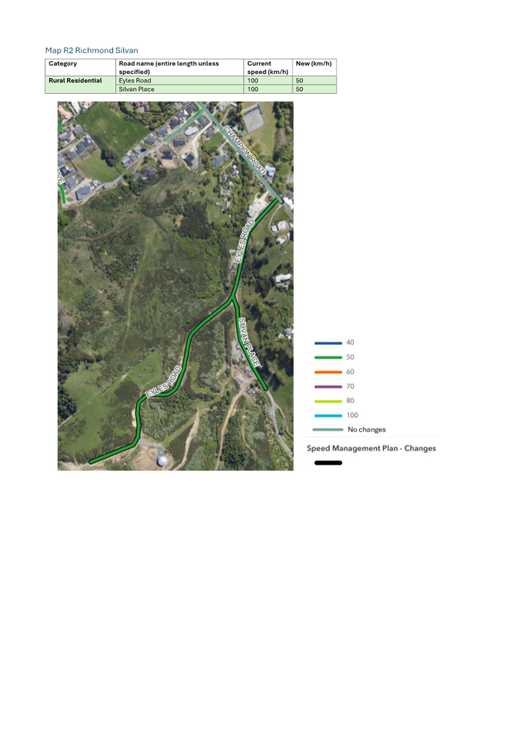
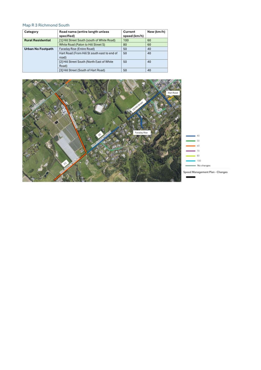
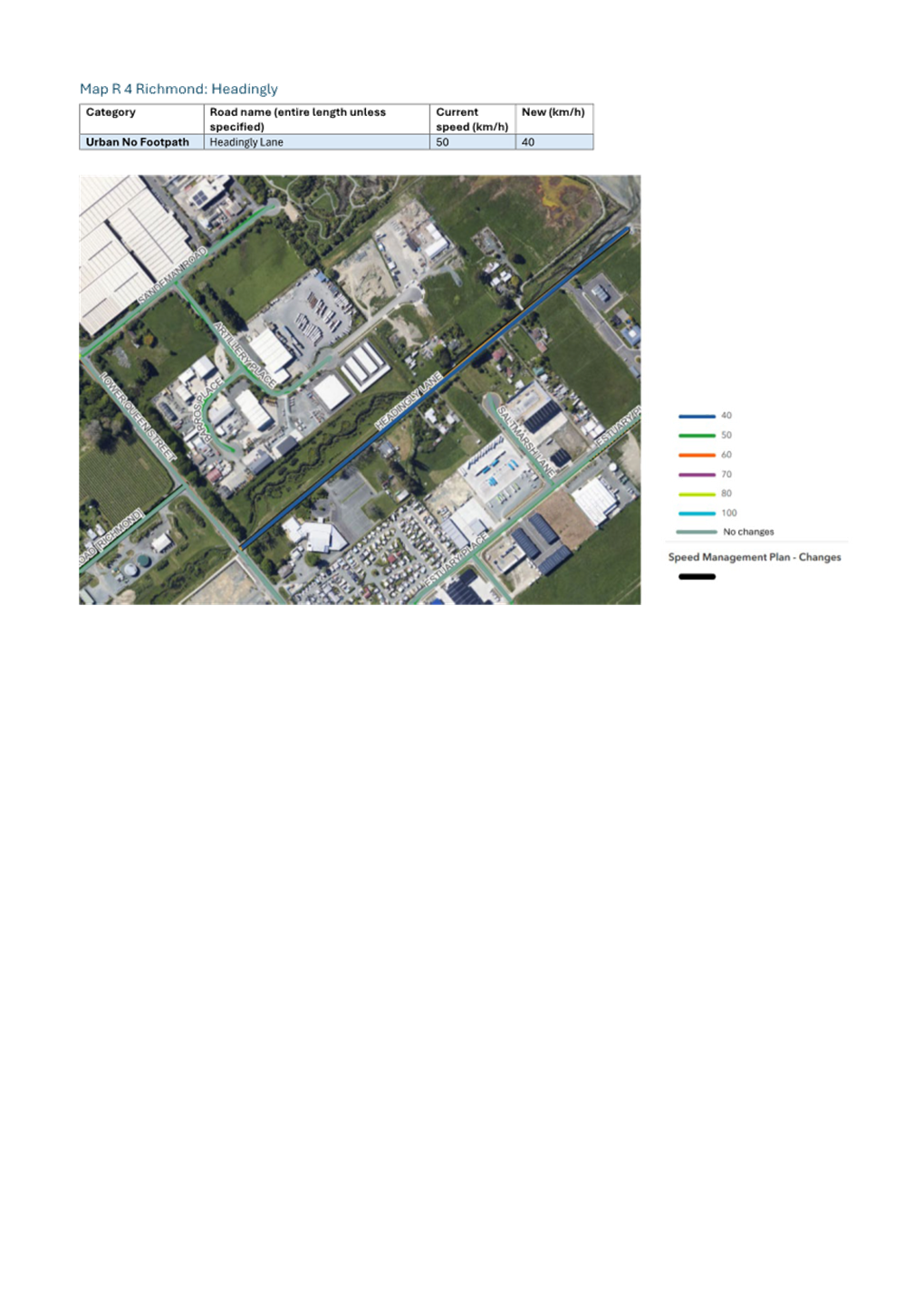
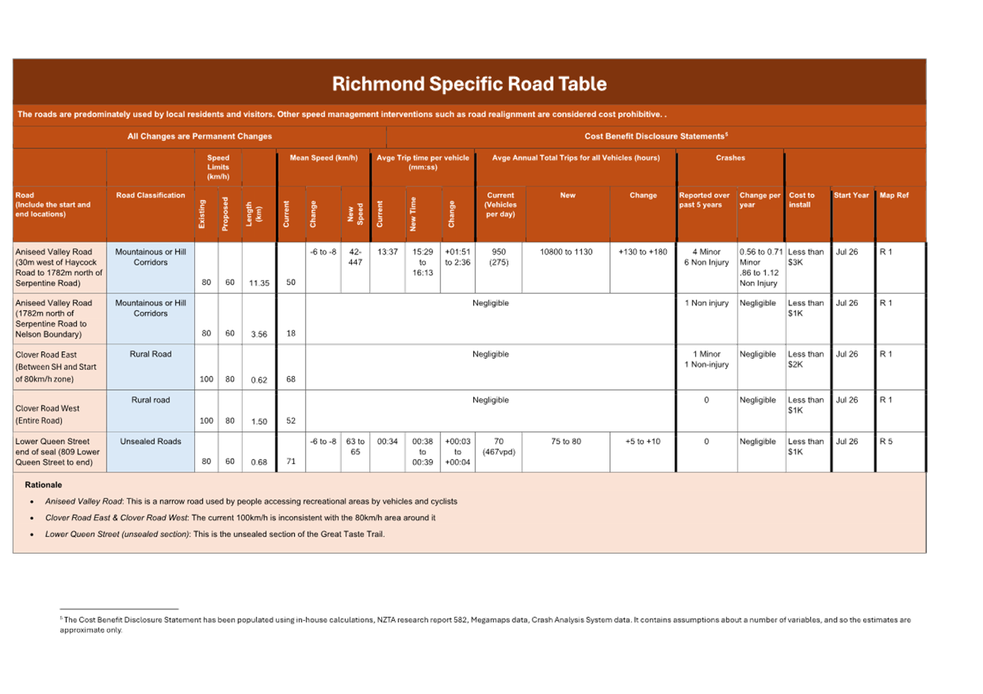
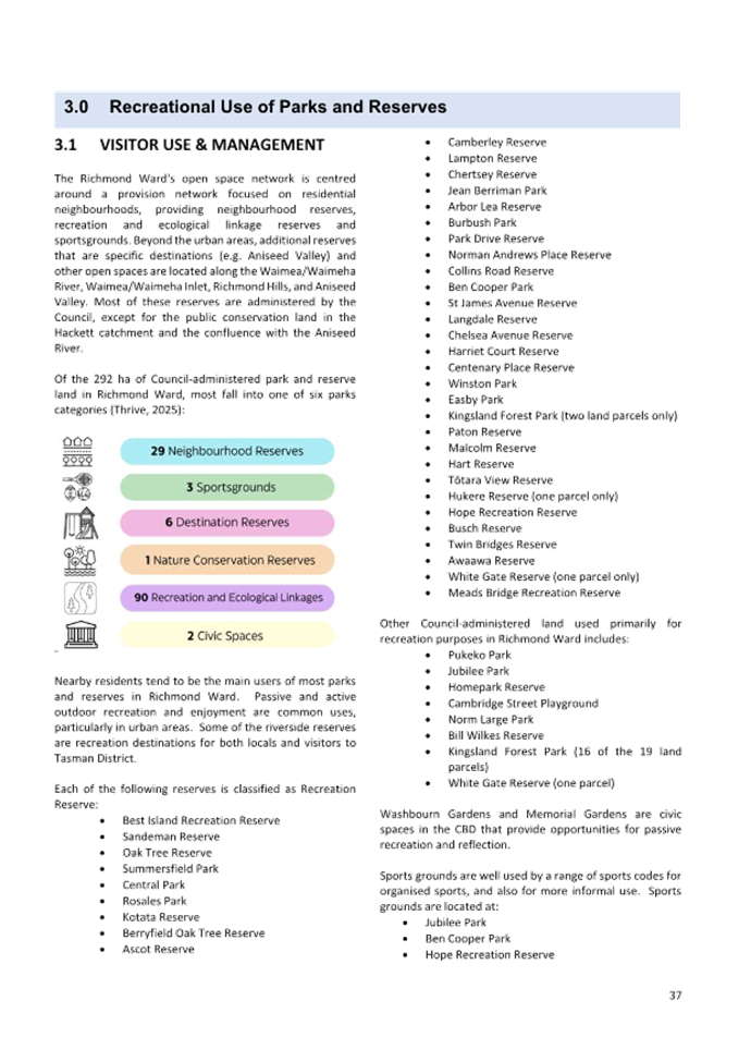
7.4 Phase Two - Speed Management Decision
Decision Required
|
Report
To:
|
Tasman
District Council
|
|
Meeting
Date:
|
14
August 2025
|
|
Report
Author:
|
Jane
Murray, Transportation Planning Advisor
|
|
Report
Authorisers:
|
Dwayne
Fletcher, Strategic Policy Manager
|
|
Report
Number:
|
RCN25-08-4
|
1. Purpose
of the Report / Te Take mō te Pūrongo
1.1 To
seek the Council’s approval of specific speed limit reductions.
2. Summary
/ Te Tuhinga Whakarāpoto
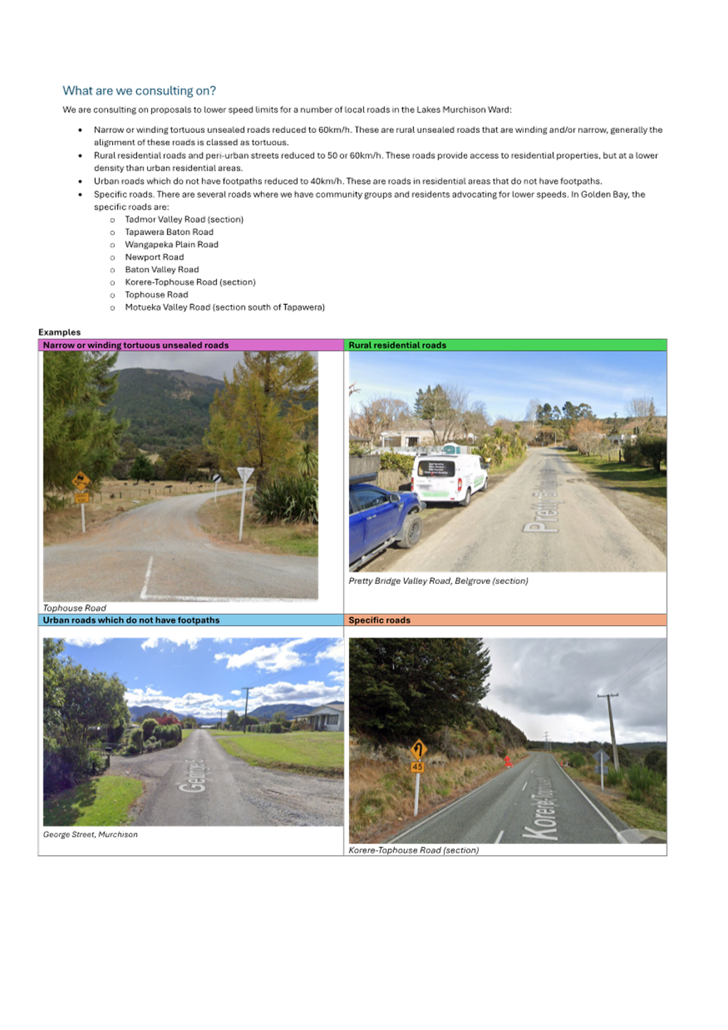
2.1 Between 9 June and 21 July 2025, the
Council consulted on speed limit reductions on the following five types of
roads:
· Narrow or winding
tortuous unsealed roads reduced to 60km/h
· Rural residential
roads and peri-urban streets reduced to 50-60km/h
· Urban roads which
do not have footpaths reduced to 40km/h
· Specific roads
2.2 We
received a total of 236 submissions during this consultation phase. We had five
ward-based surveys and received between 30-73 submissions in each ward.
2.3 The
submission results were collated with the submissions we received through the
2023/2024 submission phase. There was division amongst the general feedback
between the degree of support/opposition we received. We received conditional
organisational support from Transporting NZ and the Automobile Association. The
report shows a breakdown of the types of support and opposition that we have
received.
2.4 Following
consultation, staff recommend:
· Advisory
signs are used rather than speed reductions (with some exceptions) for the
proposals relating to Narrow and Unsealed Roads and Urban Roads without
footpaths.
· Speed
limit changes as proposed are made for rural residential roads (except for
Umukuri and Anderson Roads) and specific roads, as staff consider that the
safety benefits of reducing speed outweigh arguments regarding travel times and
efficiency.
3. Recommendation/s
/ Ngā Tūtohunga
That the Tasman
District Council
1. receives
the Phase Two - Speed Management Decision report, RCN25-08-4; and
2. receives and accepts submissions on the speed limit
changes; and
3. approves the reduction of speed limits in Attachment 1
to the agenda report: Phase Two Reductions:
3.1 Golden
Bay Rural Residential Roads
3.2 Golden
Bay Specific Roads
3.3 Lakes
Murchison Rural Residential Roads
3.4 Lakes
Murchison Specific Roads
3.5 Motueka
Rural Residentials Roads
3.6 Motueka
Specific Roads
3.7 Moutere
Waimea Rural Residential Roads
3.8 Moutere
Waimea Specific Roads
3.9 Richmond
Rural Residential Roads
3.10 Richmond
Specific Roads; and
4. agrees that the speed limit for all other roads
consulted on through Phase Two Reductions do not change, and that
advisory signs are used instead; and
5. notes that the speed limit signs on Waimea West Road
will be moved to the eastern end of the bridge to align with the National Speed
Limit Register and Council resolution in 2016.
4.1 The Regional Land Transport Plan has a
regional objective that “Communities have access to a safe transport
system regardless of mode”. The indicators for this objective are:
(a) the number of deaths and serious injuries; and
(b) deaths and serious injury as a proportion of all
crashes.
4.2 Tasman is currently not meeting the
performance target for this indicator. The figure below shows the deaths and
serious injuries (DSIs) on local roads in the Tasman District over the past 12
years.
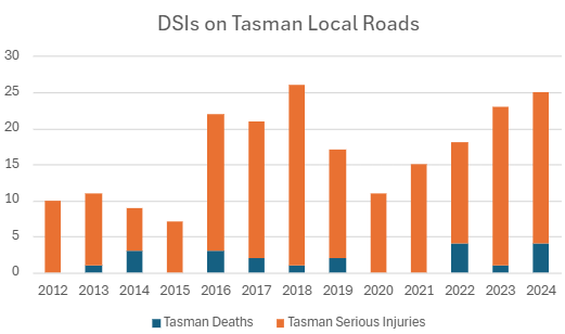
4.3 Speed management is one tool the Council
has to reduce deaths and serious injuries on our network.
4.4 Extensive
consultation on speed limits was carried out in Nelson-Tasman from 29 November
2023 to 29 February 2024, with 23 engagement sessions and 2,247 submissions.
Feedback informed both Phase One and Phase Two consultations.
4.5 The draft Setting of Speed Limits rule
was introduced on 13 June 2024. The Nelson Tasman Speed Management Plan (SMP)
was approved by the Joint Committee of Nelson City and Tasman District Councils
on 23 July 2024.
4.6 The final Setting of Speed Limits Rule
came into force on 30 October 2024. Changes in the
final Rule meant many previously approved speed limits could not be implemented
without further consultation, including cost–benefit disclosure
statements.
4.7 Due to these
requirements, consultation was split into two phases. Phase One (27 January
– 2 March 2025) focused on McShane Road, rural roads near schools, and
high-risk rural roads. The Council approved these changes on 27 March 2025, and
the New Zealand Transport Agency (NZTA) certified them on 30 May 2025. The
storm events of June-July 2025 meant that implementation was delayed by two
weeks and will occur between 28 July to 11 August 2025.
4.8 Phase Two consultation took place
between 9 June and 21 July 2025.
4.9 The Phase Two proposed changes focus on
five types of roads staff propose to change the speed limit for:
· Narrow or winding
tortuous unsealed roads (reduced to 60km/h)
· Rural residential
roads and peri-urban streets (reduced to 50-60km/h)
· Urban roads which
do not have footpaths (reduced to 40km/h)
· Specific roads
(identified by feedback or risk)
4.10 These
changes are all consistent with the approved Speed Management Plan.
4.11 Shape Tasman, Newsline and Facebook were used to
promote the consultation and targeted emails to key stakeholders such as the
Automobile Association.
4.12 The consultation document and the Ward specific
books (Attachment 7-12) shows maps of all areas.
5. Analysis
and Advice / Tātaritanga me ngā tohutohu
5.1 Since the last speed limit review in
2019, the Council has received numerous requests for reductions. Legislative
changes have delayed implementation of speed limit changes. Attachment 1:
Schedule 1: Phase Two Reductions lists the roads where changes are proposed.
Each road has been individually assessed based on the surrounding environment
and considering safety concerns and community feedback. For example, Tata Beach
Esplanade is currently 100km/h but is an urban area with a high number of
recreational visitors and no footpath, making a lower limit appropriate.
Overall feedback on our consultation:
5.2 We split the consultation by ward,
tailoring questions for each of the five areas. Submissions were received
through Shape Tasman.
|
|
# of overall respondents
|
Respondents who live in this specific ward
|
|
Golden Bay
|
30
|
77%
n= 23
|
|
Lakes Murchison
|
73
|
79%
n= 56
|
|
Motueka
|
42
|
74%
n=31
|
|
Moutere Waimea
|
48
|
71%
n=34
|
|
Richmond
|
40
|
85%
n=34
|
5.3 Some groups or individuals may not have
submitted in this round as they had already provided views in earlier
consultations.
5.4 Key themes from the submission
commentary:
The general themes
from the submissions have echoed the key themes from our two previous speed
consultations.
|
Support speed limit
reductions: Topics
|
|
General support
|
Non-specific comments about
safety, road conditions, and mixed users (e.g. cyclists, elderly, tourists).
|
|
Support for specific sites
|
Requests for lower speeds at
named locations.
|
|
Reductions improve safety
|
Belief that lower
speeds reduce crash severity
|
|
Safer for vulnerable users
|
Concerns about
cyclists, children, walkers, pets, horses.
|
|
Mismatch between road
environment and current speed limit
|
Comments relating to
increased development and tourism require lower speeds. Also, respondents
thought that there was inappropriate vehicle speeds in built-up or unsealed
areas.
|
|
Against speed changes
|
|
General opposition
|
Belief that
reductions are unnecessary, costly, ineffective, or poorly enforced.
|
|
Driver education preferred
|
Calls for more training and
better driver behaviour instead of changing speed limits.
|
|
Costs
|
Calls to spend money elsewhere:
on road surface quality
|
|
Road conditions dictate speed
|
Many submitters said people
should just adjust their speed based on factors like weather, road
conditions, visibility.
|
|
Other road
infrastructure
|
Engineering fixes (e.g.,
realigning corners, more passing bays)
|
|
Reductions cause
frustration
|
Concerns about driver
fatigue, risky overtaking, and non-compliance.
|
|
Other
|
|
Signage
|
Many submitters argue
that advisory speed signs, warning signs, or corner-specific signage are more
effective than blanket speed limit changes with Drunks Hill (Korere-Tophouse
Road) being frequently mentioned.
Golden Bay and
Motueka respondents highlight a need for clear signage near tourist areas,
one-lane bridges, and shared roads (walkers, cyclists, horses)
|
5.5 Most opposition
was general in nature, focusing on concerns about overregulation or driver
frustration, rather than objections to specific roads (with the exception of
Korere-Tophouse Road). A smaller but notable group supported speed reductions
in principle, while a minority engaged with site-specific proposals in detail.
5.5.1 Transporting NZ supports a risk-based approach to speed management and most proposed
reductions, particularly where current speeds are already low. However, they
stress that lower limits alone won’t improve safety without consistent
Police enforcement, especially on key freight routes. They urge the Council to
avoid unnecessary reductions where crash history is minimal, and safety
benefits are negligible. Several roads across Richmond, Lakes-Murchison, Golden
Bay, Moutere-Waimea, and Motueka are highlighted where proposed changes are not
justified by data or road conditions.
Attachment 6: Transporting NZ Submission shows the full submission.
Response: Transporting NZ focuses heavily on mean vehicle travel speeds but
overlooks the presence of more vulnerable road users – such as cyclists
on roads like Goodall Road, Tadmor Valley Road, Redwood Road (Appleby) which
form part of Tasman’s Great Taste Trail. It is estimated that these users
contribute $34 million to the Nelson/Tasman economy.[1]
This economic benefit has been considered in the speed limit recommendations
pertaining to these roads. The submission also focuses on the additional travel
times which are very low for the roads (between one to 14 seconds).
5.5.2 Nelsus responded to the
Richmond and Motueka surveys and supported all changes except for a section of
Umukuri Road.
5.5.3 Response: Umukuri Road and Anderson Road have been removed from the list of
recommended speed limit changes.
5.5.4 Motueka Community Board
supported recommended safe speed signs and warning signs of road curves. They
suggested consistent implementation of 40km/h, 60km/h, 80km/h, 100km/h rather
than 30km/h, 50km/h and 70km/h zones. They support using road improvements,
road safety education and speed guidance. They recommended direct consultation
with affected residents.
Attachment 5: Motueka Community Board submission: shows the full submission
Response: Staff support a consistent, rule-aligned approach to speed
management. The Board’s recommended speed limits do not align with the
new Setting of Speed Limits Rule.
While direct
consultation with residents on affected streets would have been ideal, budget
and staff resource constraints made this unfeasible. However, the consultation
did ask whether respondents lived on affected streets, as shown in Attachment
3: Phase 2 Feedback 2024 to 2025 Consultations. Collecting detailed
demographic or mode-of-transport data was not possible due to the length of the
survey.
Police: No response.
5.6 Narrow or winding tortuous unsealed
roads:
5.6.1 Context:
Many narrow or
winding unsealed roads in Tasman have 100km/h speed limits. As part of our speed management review, we considered reducing
these limits to improve safety and consistency for drivers. This aligns with
the Safe and Appropriate Speed principles in the 2022 Rule. Although the 2024
Rule does not have a legal requirement to reduce speeds on these roads, it
requires that any new speed limits on all unsealed roads be 60–80 km/h.
5.6.2 Crash data:
Crash records
show few crashes on these roads, but minor and non-injury crashes are often
under-reported, particularly in the remote locations typical of these roads.
Combined with low traffic volumes, this suggests the actual crash rate per
kilometre travelled may be higher than the data suggests.
5.6.3 Phase Two consultation options:
Two options
were presented
· Reduce the speed to 60km/h
· Use advisory speed signs.:
5.6.4 Narrow or Winding Tortuous Unsealed Results by Ward
|
|
Support
|
|
Against
|
|
|
|
Support Lower Limit
|
Support lower limits plus signs
|
More signs only
|
Status Quo
|
|
Golden Bay – Mangarakau &
Whanganui Inlet (6 roads)
|
24% n=17
|
24% n=7
|
7% n=2
|
45% n=13
|
|
Golden Bay (not in Mangarakau area) (8
roads)
|
22% n=6
|
22% n=6
|
11% n=3
|
46% n=13
|
|
Lakes Murchison (17 roads)
|
19% n=13
|
16% n=11
|
22% n=15
|
42% n=28
|
|
Motueka (4 roads)
|
43% n=17
|
23% n=9
|
10% n=4
|
25% n=10
|
|
Moutere Waimea – Motueka River West
Bank Area (8 roads)
|
24% n=10
|
26% n=11
|
12% n=5
|
38% n=16
|
|
Moutere Waimea – (Not River West
Bank Area) (9 roads)
|
30% n=13
|
23% n=10
|
9% n=4
|
39% n=17
|
|
Richmond (1 road)
|
30% n=11
|
16% n=6
|
8% n=3
|
46% n=12
|
*Note: “Support column”
includes both “Lower limit and “Lower limit plus Signs”
categories
5.6.5 Summary of Support:
Motueka and
Moutere Waimea wards showed the strongest support for lower limits. Golden Bay
respondents preferred lower speeds for Mangarakau and Whanganui but were more
divided for speeds elsewhere. Richmond respondents were equally divided. Lakes-
Murchison, which has the highest number of narrow winding unsealed roads, only
had 35% of respondents supporting lower speeds.
In a 2020 survey, 91% of respondents supported speeds below 100 km/h—59%
favoured
60 km/h, and 32% preferred 80 km/h. Lower participation in 2025 may reflect
consultation fatigue.
5.6.6 Road Specific Feedback:
We received
very few comments specifically about narrow & winding unsealed roads with
four comments supporting reduced speed on Tophouse Road.
Ten respondents
specifically stated that they supported all proposed changes on the narrow
winding unsealed roads. Two respondents did not support any changes, two others
requested reductions on all unsealed roads, and one preferred a reduction to
80km/h rather than 60km/h. Several respondents also expressed support for
changes at specific locations:
Lakes
Murchison: Tophouse Road n=4, Wangapeka Plain Road n=1,
Golden Bay:
Mangarakau/Wanganui n=3, Rameka Creek n=2
Motueka: Rocky
River Road n=1, Pokororo n=1
Moutere Waimea:
Pig Valley Road n=1, Wairoa Gorge Road, n=1 [Thorpe-Orinoco Road received 6
requests for reductions]
Richmond:
Aniseed Valley Road n=5
5.6.7 Funding and Signage:
Under the
previous 2022 Rule, co-funding from NZTA was expected. The 2024 Rule and new
Government Position Statement limit funding to speed changes near schools. In
response, the Council has considered advisory signs as a more cost-effective
alternative. Advisory signs are less expensive and need fewer
installations—one every 8 km vs every
2 km for formal speed limit signs. The speed management guide states
that repeater signs are not usually necessary if the nature of a particular
length of road is such that a road user would reasonably understand that the
speed limit displayed on the last speed limit sign remains the speed limit on
the road throughout the whole of that length of road.” This applies
to most of our tortuous unsealed roads
Advisory signs
are not legally enforceable but help guide safe speeds, especially where police
presence is limited. Some of these roads already lack posted speed limits.
Recommended
Approach
Advisory signs are recommended for
roads in this category, except for Totaranui Road and Awaroa Road. These roads
provide access to Abel Tasman National Park and are heavily used by visitors.
The roads have been moved to the Specific Roads section. The Lee Valley
and Wairoa Gorge area were included for 80km/h limits in the Specific Road
section. Pig Valley Road and Andrews Road, which are narrow and winding roads,
nearby, are now also proposed to be 80km/h to create a consistent speed zone
across the area.
5.6.8 Weather
impacted Roads:
Some roads
(e.g. Pigeon Valley, Wangapeka West Bank) have been affected by storm damage.
Advisory signs provide flexibility to adjust or delay installation as needed,
based on site conditions.
5.6.9 Recommendation
Use advisory
signs on these roads, except for the four listed in the Specific Roads section
[Totaranui Road, Awaroa Road, Andrews Road, Pig Valley Road], where formal
speed reductions are recommended. See Attachment 1: Schedule 1: Phase
Two Reductions and Attachment 2: Advisory Signs List
5.6.10 Estimated Costs by Ward
|
Ward
|
Speed limit reductions
Only
|
Advisory Signs
Only
|
Preferred option:
Advisory signs (except
Totaranui Awaroa, Andrews, Pig Valley Roads)
|
|
Golden
Bay
|
$32,000
|
$13,000
|
$11,000
(+2 speed limit reductions = $4,000)
|
|
Lakes
Murchison
|
$25,000
|
$16,000
|
$16,000
|
|
Moutere Waimea
|
$20,000
|
$13,000
|
$11, 000
(+2 speed limit reductions = $2,000)
|
|
Motueka
|
$7,000
|
$3,000
|
$3,000
|
|
Richmond
|
$1,000
|
Less
than $1,000
|
Less than
$1,000
|
|
Total
|
$85,000
|
$46,000
|
$44,000
Advisory signs
$4,000 Speed limit reductions
$48,000
Total
|
|
Note: Additional treatment
may be needed on some roads with known safety risks.
|
5.7 Rural residential roads:
5.7.1 Context:
Many rural residential streets
in Tasman have speed limits of 80–100 km/h, which are too high for their
function. These roads serve low-density housing, lack
footpaths, and are used for walking, cycling, and recreation. Residents
frequently request lower speeds. Under the Speed Limit Setting Rule, limits of
50–80 km/h are permitted for these roads.
5.7.2 Community
Feedback:
We were unable to directly
target residents due to budget constraints, but the consultation asked if
respondents lived on roads proposed for speed reductions. Of 71 people who did,
83% supported the reductions, and 17% did not.
· Mārahau
Valley Road: 12 supported
· Fairfax
Road: 10 supported, 1 opposed
More detail is in Attachment
3: Phase 2 Feedback 2024 to 2025 Consultations.
5.7.3 Rural
Residential Results by Ward
|
|
Support
|
|
Against
|
|
|
Yes to All
|
Support in part
|
Neutral
|
No to All
|
|
Golden Bay (13 roads)
|
43% n=13
|
10% n=3
|
3% n=1
|
43% n=13
|
|
Lakes-Murchison (6 roads)
|
43% n=29
|
7% n=5
|
15% n=10
|
35% n=24
|
|
Motueka - not Brooklyn (8 roads)
|
54% n=21
|
0% n=0
|
13% n=5
|
33% n=13
|
|
Motueka – Brooklyn/Riwaka Area (8
roads)
|
45% n=18
|
5% n=2
|
15% n=6
|
35% n=14
|
|
Moutere Waimea – Not Kina, Ruby
Bay, Seaton or Westdale) (32)
|
44% n=19
|
0%
|
9% n=4
|
47% n=20
|
|
Moutere-Waimea – Kina Beach (5
roads)
|
46% n=21
|
9% n=4
|
9% n=4
|
37% n=17
|
|
Moutere-Waimea – Ruby Bay (5 roads)
|
48% n=21
|
0% n=0
|
11% n=5
|
41% n=18
|
|
Moutere-Waimea – Seaton Valley
|
38% n=16
|
-
|
14% n=6
|
48% n=20
|
|
Moutere-Waimea – Westdale, Rabbit
Island (5 roads)
|
33% n=14
|
2% n=1
|
26% n=11
|
40% n=17
|
|
Richmond n=5
|
46% n=17
|
11% n=4
|
5% n=2
|
38% n=14
|
5.7.4 Summary
of Feedback
· Over half of
respondents in Golden Bay, Motueka, Lakes Murchison, and Richmond wards
supported speed limit reductions.
· Moutere-Waimea
which has the highest number of rural residential roads, had five questions
relating to this type of road.
o Support was highest for
Kina Beach (54%) and Ruby Bay (48%) areas
o Support was lower for
Seaton Valley (38%) and Westdale Rabbit Island (35%).
o In 2024, 15 specifically
requested reductions on Bronte East Road and spoke at the hearings.
· Across other
rural residential areas in Moutere-Waimea, 44% supported reductions, while 47%
did not.
5.7.5 Written
Feedback on Rural Residential Roads
5.7.6 For this round of consultation, there were very few people with
specific comments supporting reductions on rural residential roads. Fairfax
Road and Mārahau Valley Road received the most responses.
· Golden
Bay: Rangihaeta area n=6
· Lakes
Murchison: Fairfax Street n=10, Matakitaki n=3
· Motueka:
Mārahau Valley Road and Harvey Road n=9, Starnes Road n=3
· Moutere
Waimea: Kina Beach Road & Cliff Road n=5
· Richmond:
Haycock Road n=3
· Fairfax
Street n=10
· Mārahau
Valley Road n=9
5.7.7 Two submissions asked that Umukuri Road be excluded from
the rural residential section, noting it is mostly straight, has few houses,
and serves as a bypass for Riwaka. Staff agree and recommend no changes to
Umukuri or Anderson Roads. In 2024, we ran more engagement sessions and had
increased media coverage, which led to higher public participation in the
consultation process and more requests for speed limit reductions on rural
residential roads. especially in the following areas:
· Golden Bay: Glenview Road n=10, Rangihaeta Road n=4,
· Motueka
Whakarewa Street n=8, Douglas Road n=4
· Moutere
Waimea: Bronte East Road n=15, Old Coach Road n=4, Westdale Road, n=4, Pomona
Road n=3, Marriages Road n=3,
· Richmond:
Haycock Road n=3
5.7.8 Recommendation:
Although posted
limits are 80–100 km/h, average speeds on these roads are between
35–45 km/h due to road width, lack of markings, poor visibility, and
shared use.
Formal reductions to 50 or 60 km/h better reflect how these roads are used and
improve safety for all users.
We recommend
proceeding with the proposed speed limit reductions for rural residential
roads, based on:
· Community feedback
· Current road use and design
· Alignment with national guidance and observed speeds.
We recommend all rural residential roads
are reduced except for Umukuri Road and Anderson Road.
5.7.9 Estimated
Costs by Ward of recommended option
|
Ward
|
Speed
Limit Reductions
|
|
Golden
Bay
|
$15,000
|
|
Lakes-Murchison
|
$10,000
|
|
Moutere-Waimea
|
$65,000
|
|
Motueka
|
$20,000
|
|
Richmond
|
$10,000
|
5.8 Urban roads which do not have footpaths:
5.8.1 Context
Some urban
residential streets in Tasman lack footpaths, creating safety risks for
pedestrians and cyclists. Nelson Tasman Regional Transport Committee advocated
for these types of urban streets to have a new category in the 2024 Rule. While the committee recommended 30 km/h, the final Speed Setting
Rule requires 40 km/h when a new limit is set, but there is no requirement to
change existing limits.
5.8.2 Phase Two Consultation Options
Two options
were presented:
· Reduce the speed limit to 40km/h
· Use advisory signs.:
Advisory signs have been used successfully on short or low-traffic
streets. These signs are not enforceable but help guide safer driving.
|
|
Support
|
|
Status Quo
|
|
|
Lower
|
Lower speeds & add signs
|
More signs
|
Status Quo
|
|
Golden Bay
|
29% n=8
|
21% n=6
|
4% n=1
|
46% n=13
|
|
Lakes-Murchison*
|
37% n=25
|
3% n=2
[support in part]
|
16% n=11 [neutral]*
|
44% n=30
|
|
Motueka
|
39% n=15
|
26% n=10
|
5% n=2
|
29% n=11
|
|
Moutere-Waimea - General
|
32% n=13
|
20% n=8
|
10% n=4
|
39% n=16
|
|
Richmond*
|
36% n=13
|
6% n=2
[support in part]
|
8% n=3 [neutral]*
|
50% n=18
|
|
*There
was an error in the questions for the Lakes Murchison and Richmond where the
question asked was stated as (Support/Neutral/Against) instead of the
standard four options.
|
5.8.3 Summary of Feedback
Golden Bay and
Motueka Wards supported speed reductions for these types of roads. Richmond and
Lakes Murchison were not in support although these two wards have very few of
these types of roads compared with Golden Bay and Motueka.
We only
received three comments, one supporting reductions on Headingly Lane, one
supporting reductions on Green Tree Road and Wharf Rod (Riwaka), and one
requesting that Rangihaeta Road be reduced to 40km rather than 50km.
In 2024, more
feedback was received from areas like Tata Beach (Golden Bay, n=4). Golden Bay:
Tata Beach area n=4.
5.8.4 Recommended Approach:
The rationale
for the inclusion of urban roads without footpaths in the joint Nelson Tasman
Speed Management Plan was to have a consistent approach across the region
including both Nelson and Tasman. However, many of Nelson’s urban roads
without footpaths were reduced to 30km/h prior to the Speed Management Plan,
and the 2024 Setting of Speed Limits Rule only allows for new limits of 40km/h
for these streets, and allows existing limits to remain unchanged. It is
therefore not possible to achieve consistency across the region as originally
intended.
In 2020, 86% of
survey respondents supported limits below 50 km/h on streets without footpaths.
Many of these roads are short, with low volumes of traffic, and already have
average speeds below 50 km/h. To manage safety and costs, we propose a
three-tiered approach.
Tier one:
Use cautionary signs
Default option
unless road meets Tier Two criteria.
Tier two:
Reduced speed limit to 40km/h if the road
a. Has posted speed limit above 50km/h or
b. Is in, or adjacent to, a recreational area, or
town centre or
c. Has no berms for pedestrians or
d. Has crashes
Tier three:
No signs needed if:
a. Road is shorter than 200m or
b. No crash history and average speeds are below
40km/h
It is considered
that this approach balances safety with cost-effectiveness.
Tier
Two roads are listed in the Specific Roads section.
Tier Two Urban
Roads Recommended for Speed Limit Reduction (to 40km/h)
|
|
Road
|
Rationale
|
|
Golden Bay
40km/h
|
· Junction Road
|
In town centre,
higher number of walkers
|
|
· Reilly Street
|
In town centre,
higher number of walkers, adjacent to the playground. One non-injury crash
|
|
· Kendal Street
|
Recreational area,
higher number of walkers, currently 100km/h
|
|
· Nelson Street
|
Recreational area,
higher number of walkers, currently 100km/h
|
|
· Totara Avenue
|
Residential street,
currently 100km/h
|
|
50km/h
No sign needed
|
· Harwood Place
|
Currently 100km/h,
change to 50km/h [no sign needed]
|
|
· Patons Rock Road Beach Access
|
Currently 100km/h
change to 50km/h [no sign needed]
|
|
· Tata Beach Esplanade
|
Currently 100km/h
change to 50km/h [no sign needed]
|
|
Lakes-Murchison
|
None Identified
|
|
|
Motueka
|
Anerewa Crescent
|
Recreational area
|
|
Cook Crescent
|
Recreational area
|
|
· Stephens Bay Road
|
Recreational area
|
|
· Tapu Place
|
Recreational area
|
|
· Community Road
|
Half of this road
is privately owned. Tasman’s Great Taste Trail runs the length of the
road with the Riverside community adjacent. (2024: Average daily use 60
cyclists at Pine Hill Road). Riverside section is signposted at
30km/h and we recommend the road is consistent with this..
|
|
· Inlet Road
|
Inconsistent with
30km/h area around it
|
|
Moutere- Waimea
|
· None identified
|
|
|
Richmond
|
· Headingly Lane
|
Recreational area
and has section of Tasman’s Great Taste Trail
|
Tier three
(no signage required)
Golden Bay: Tennyson Street, Prior Road, Patons Rock Road, Parapara Beach Road
Lakes
Murchison: George Street
5.8.5 Recommendation
Use advisory
signs on these roads, except for the Tier Two Road listed above, where formal
speed reductions are recommended. See Attachment 1: Schedule 1: Phase Two
Reductions and Attachment 2: Advisory Signs List
Cost
Estimate by Ward
|
Ward
|
Speed limit reductions
|
Advisory Signs*
|
Preferred option: Advisory
signs with some exceptions
|
|
Golden
Bay
|
$24,000
|
$20,000
|
$7,000
(+5 speed limit reductions = $7,000)
|
|
Lakes
Murchison
|
$2,000
|
$2,000
|
$1,000
|
|
Moutere Waimea
|
$2,000
|
$2,000
|
$2,000
|
|
Motueka
|
$10,000
|
$7,000
|
$2,000(+6
speed limit reductions = $8,000)
|
|
Richmond
|
$6,000
|
$5,000
|
$3,000 (+
1 speed limit reductions = $1,000)
|
|
Total
|
$44,000
|
$36,000
|
$15,000
Advisory signs
$16,000 Speed limit reductions
$31,000
Total
|
|
Some roads may need further
treatment should safety concerns emerge
|
5.9 Specific
Roads
5.10 Overview
This section
covers roads that don’t fit into other categories. Speed limit reductions
are proposed due to specific factors unique to each road—such as
mismatched speed limits, safety concerns raised by residents or the Council,
high numbers of walkers or cyclists, or changes to the road environment.
This table below summarises
proposed speed limit changes for individual roads, including:
· Road length
· Current and proposed speed limits
· Average (mean) operating speed
· Number of reported injuries (2019–2024)
· General support from consultation
· Comments from the 2024 and 2025 consultations
· Rationale for the change
Note: One crash may involve multiple
injuries, and many minor crashes go unreported, particularly in remote areas.
5.11 Recommended
approach
The Urban Roads without
Footpaths Tier Two list and the four roads from the Narrow/Winding Unsealed
Roads have been moved to the Specific Roads section. It is recommended that all
these speed limit reductions are approved.
|
Golden Bay
|
|
Injury code: F = Fatal, S=Serious Injury, M= Minor Injury, NI=
Non Injury
|
|
|
Speed (km/h)
|
|
Feedback
|
Requests to reduce
|
Commentary
|
|
Road name
|
Posted
|
New
|
Mean
|
Length
(km)
|
Crash
|
Yes
|
Neutral
|
No
|
|
|
Abel Tasman Drive
(Pohara Valley Road to 1570 Abel Tasman Drive(southern boundary))
|
60
|
50
|
45
|
6.65
|
1M
|
43%
n=12
|
7%
n=2
|
50%
n=14
|
2025 n=1
2024: n=5
No change n=1
|
Multiple requests to
lower speeds around Port Tarakohe, Ligar and Tata Beach, due to high
pedestrians/ cyclists use and heavy vehicles accessing the port. Wainui
section is narrow.
Golden Bay Community
Board requested a reduction in 2024 and 2025
|
|
Abel Tasman Drive (1570
Abel Tasman Drive to 1597 Abel Tasman Drive (northern boundary))
|
60
|
50
|
45
|
0.20
|
0
|
43%
n=12
|
7%
n=2
|
50%
n=14
|
2024: n=1
|
Rural residential area
which is adjacent to an area where we are recommending a reduction to 50km/h
|
|
Anatoki Track Road
(Entire Length)
|
100
|
80
|
17
|
0.81
|
0
|
36%
n=10
|
18%
n=5
|
46%
n=13
|
0
|
Residents’ safety
concerns have been raised with Ward Councillors.
|
|
Awaroa Road (Entire
Road)*
*Feedback from general
question: Unsealed, narrow, winding roads
|
100
|
60
|
16
|
4.03
|
0
|
43%
n=12
|
More
signs
11%
n=3
|
46%
n=13
|
0
|
This is narrow winding
road which has torturous alignment. Used to access key recreational areas.
This section is included for consistency with Totaranui Road.
|
|
Cemetery Road (Entire
Length)
|
100
|
80
|
15
|
0.38
|
0
|
36%
n=10
|
18%
n=5
|
46%
n=13
|
0
|
Residents’ safety
concerns have been raised with Ward Councillors.
|
|
Collingwood Quay (Entire
Length)
|
70
|
50
|
56
|
0.42
|
0
|
46%
n=13
|
4%
n=1
|
50%
n=14
|
0
|
Because the area is
recreational and has no footpaths, a lower speed limit is proposed.
|
|
Collingwood Bainham Main
Road (existing 70 km/h to SH)
|
70
|
50
|
35
|
0.56
|
1NI
|
46%
n=13
|
4%
n=1
|
50%
n=14
|
0
|
This road is considered
as part of the urban environment of Collingwood, a lower speed limit is
proposed
|
|
Collingwood-Puponga Main
Road (Pakawau Bush Road to 1088 Collingwood -Puponga Main Road (existing
60km/h zone)
|
60
|
50
|
59
|
2.12
|
1M
1NI
|
43%
n=12
|
4%
n=1
|
54%
n=15
|
2024: n=1
No change n=1
|
The reduction is
proposed due to the area’s urban and recreational use, and the absence
of a footpath.
|
|
Collingwood-Puponga Main
Road (end of existing 60km/h zone (1088 Collingwood-Puponga Main Road) to 75m
south of southern boundary of 1062 Collingwood -Puponga Main Road)
|
100
|
50
|
62
|
0.31
|
0
|
43%
n=12
|
4%
n=1
|
54%
n=15
|
2024: n=5
|
The reduction is
proposed due to the area’s urban and recreational use, and the absence
of a footpath. The township has grown in size and this is a 310m extension of
the urban area
|
|
East Takaka Road (From
Central Takaka Road south 570m)
|
100
|
80
|
76
|
0.57
|
0
|
32%
n=9
|
25%
n=7
|
43%
n=12
|
0
|
Residents safety
concerns have been raised with Ward Councillors.
|
|
Glenview Road (Central
Takaka Road to 120m south west of Packard Drive)
|
100
|
80
|
59
|
3.87
|
1M
1NI
|
32%
n=9
|
25%
n=7
|
43%
n=12
|
2024: n=4
|
Used as a the shortest
route between Central Takaka and Pohara, There have been two accidents.
|
|
Harwood Place (Entire
Road)
*Feedback
from general question: Urban Roads with No Footpath
|
100
|
50
|
12
|
0.17
|
0
|
50%
n=8
|
More signs
4%
n=1
|
46%
n=13
|
0
|
Current speed limit is 100km/h,
make 50km/h because it is an urban area.
|
|
Hill View Road (Entire
Length)
|
100
|
80
|
18
|
0.38
|
1NI
|
32%
n=9
|
25%
n=7
|
43%
n=12
|
0
|
Consistency with
Glenview & Rameka Creek Roads.
|
|
Langford Road (Entire
Length)
|
100
|
80
|
20
|
0.57
|
0
|
36%
n=10
|
18%
n=5
|
46%
n=13
|
0
|
Consistency with Long
Plain Road
|
|
Long Plain Road (Entire
Length)
|
100
|
80
|
54
|
8.2
|
2NI
|
36%
n=10
|
18%
n=5
|
46%
n=13
|
2024: n=8
|
Residents’ safety
concerns have been raised with Ward Councillors.
|
|
Junction Street (Entire Road)
*Feedback
from general question: Urban Roads with No Footpath
|
50
|
40
|
10
|
0.15
|
0
|
50%
n=8
|
More signs
4%
n=1
|
46%
n=13
|
0
|
Urban Road with No
Footpath. In town centre, high number of pedestrians.
|
|
Kendal Street (Entire Road)
*Feedback
from general question: Urban Roads with No Footpath
|
100
|
40
|
46
|
0.15
|
0
|
50%
n=8
|
More signs
4%
n=1
|
46%
n=13
|
2024: n=2
|
Urban Road with No
Footpath. Recreational area, higher number of walkers, currently 100km/h
|
|
McCallum Road (Entire
unsealed section)
|
100
|
60
|
38
|
3.70
|
0
|
36%
n=10
|
18%
n=5
|
46%
n=13
|
2024: n=8
|
The unsealed section is
proposed to be reduced to 60km/h because a large section of it is classed as
narrow/winding with tortuous alignment.
|
|
McCallum Road (Long
Plain Road to end of the seal)
|
100
|
80
|
49
|
2.35
|
0
|
36%
n=10
|
18%
n=5
|
46%
n=13
|
2024: n=8
|
Limit is proposed to
drop to 80km/h because of traffic to the Anatoki salmon farm. In 2024,
Anatoki Salmon Farm has requested a 60km/h limit on this section.
|
|
Milnthorpe Quay (Nelson
Street to end of the road)
|
100
|
40
|
27
|
0.10
|
0
|
50%
n=13
|
8%
n=2
|
42%
n=11
|
2024: n=2
|
This narrow road leads
to the wharf and is used by many recreational visitors.Consistent with
proposed limit on Nelson Street
|
|
Moulder Road (Entire Length)
|
100
|
80
|
23
|
0.49
|
0
|
36%
n=10
|
18%
n=5
|
46%
n=13
|
0
|
Consistency with Long
Plain Road.
|
|
Nelson Street (Entire Road)
*Feedback
from general question: Urban Roads with No Footpath
|
100
|
40
|
29
|
0.45
|
0
|
50%
n=8
|
More signs
4%
n=1
|
46%
n=13
|
2024: n=2
|
Urban Road with No
Footpath. Recreational area, higher number of walkers, currently 100km/h
|
|
One Spec Road (Entire Length)
|
100
|
80
|
38
|
3.03
|
0
|
36%
n=10
|
18%
n=5
|
46%
n=13
|
2024 n=1
|
Consistency with Long
Plain Road .
|
|
Packard Road (Entire Length)
|
100
|
80
|
44
|
3.20
|
1NI
|
32%
n=9
|
25%
n=7
|
43%
n=12
|
0
|
Residents’ safety
concerns have been raised with Ward Councillors.
|
|
Patons Rock Road Beach
Access (Entire Road)
*Feedback
from general question: Urban Roads with No Footpath
|
100
|
50
|
NA
|
0.04
|
0
|
50%
n=8
|
More signs
4%
n=1
|
46%
n=13
|
0
|
Recreational area,
higher number of walkers. Currently 100km/h. Recommend making 50km/h so it is
consistent with surrounding area.
|
|
Rameka Creek Road
(Glenview Road to 1204m south of Hill View Road)
|
100
|
80
|
24
|
1.56
|
1S
|
32%
n=9
|
25%
n=7
|
43%
n=12
|
2025 n=2
2024 n=2
|
Consistency with
Glenview Road.
|
|
Reilly Street (Entire Road)
*Feedback
from general question: Urban Roads with No Footpath
|
50
|
40
|
28
|
0.15
|
1NI
|
50%
n=8
|
More signs
4%
n=1
|
46%
n=13
|
2024 n=1
|
Urban Road with No
Footpath. In town centre, high number of pedestrians.
|
|
Tata Beach Esplanade
(Entire Road)
*Feedback
from general question: Urban Roads with No Footpath
|
100
|
50
|
13
|
0.14
|
0
|
50%
n=8
|
More signs
4%
n=1
|
46%
n=13
|
2024 n=3
|
Currently 100km/h.
Recommend making 50km/h so it is consistent with surrounding area
|
|
Totara Avenue (Entire
Road)
*Feedback
from general question: Urban Roads with No Footpath
|
100
|
40
|
19
|
0.68
|
0
|
50%
n=8
|
More signs
4%
n=1
|
46%
n=13
|
2024 n=3
|
Urban Road with No
Footpath, residential street. Currently 100km/h
|
|
Totaranui Road (Entire
Lengh)
|
100
|
60
|
26
|
10.5
|
1M
1N
|
43%
n=12
|
More
signs
11%
n=3
|
46%
n=13
|
2024 n=1
|
Narrow and tortuous.
Route to a popular recreational area.
|
|
|
|
|
|
|
|
|
|
|
|
|
|
|
|
Lakes-Murchison
|
|
|
Speed (km/h)
|
|
Feedback
|
Requests to reduce
|
Commentary
|
|
Road name
|
Posted
|
New
|
Mean
|
Length
(km)
|
Injury
|
Yes
|
Neutral
|
No
|
|
|
Korere Tophouse /
Tophouse (570m north of Tophouse Road to State Highway 63)
|
100
|
80
|
72
|
4.06
|
1S
3M
5NI
|
26%
n=19
|
22%
n=16
|
51%
n=37
|
2025: n=5
No change n=11
2024: n=1 (straight
section)
No change n=1
|
While some respondents
opposed a speed reduction, there have been multiple injury crashes on this
section of road. The nearby state highway is already 80km/h, so this change
ensures consistency.
|
|
Motueka Valley Highway
(existing 50km/h (15m south of 20 Main Road Tapawera) to existing 80km/h area
(352m south of southern boundary of Mararewa Cemetery))
|
100
|
80
|
86
|
2.84
|
1S
1M
4NI
|
21%
n=14
|
38%
n=26
|
41%
n=28
|
2024: n=1 (straight
section)
No change n=1
|
Southern approach to
Tapawera. Residents safety concerns have been raised with Ward Councillor
(six recorded crashes). Not supported by Transporting NZ.
|
|
Tadmor Valley Road (For
1775m from Main Road Tapawera)
|
100
|
80
|
84
|
1.78
|
4NI
|
19%
n=13
|
46%
n=32
|
36%
n=25
|
0
|
Western approach to
Tapawera. 80km/h recommended due to four crashes. Not supported by
Transporting NZ.
|
|
Tophouse Road (Entire
Length)
|
100
|
80
|
38
|
1.73
|
1M
|
26%
n=19
|
22%
n=16
|
51%
n=37
|
2024: n=1
|
A long section of this
road is narrow and tortuous. An 80km/h limit is recommended for consistency
with State Highway and Korere Tophouse
|
|
|
|
|
|
|
|
|
|
|
|
|
|
Motueka
|
|
Injury code: F = Fatal, S=Serious Injury, M= Minor Injury, NI=
Non Injury
|
|
|
Speed (km/h)
|
|
Feedback
|
Requests to reduce
|
Commentary
|
|
Road name
|
Posted
|
New
|
Mean
|
Length
(km)
|
Crash
|
Yes
|
Neutral
|
No
|
|
|
Alexander Bluff Road
Bridge
|
100
|
80
|
36
|
0.17
|
0
|
44%
n=18
|
29%
n=12
|
27%
n=11
|
2024 n=2
|
Bridge limit is proposed
to be aligned with limit on Motueka Valley Highway.
|
|
Anarewa Crescent (Entire Road)
|
50
|
40
|
19
|
0.31
|
0
|
59%
n=24
|
15%
n=6
|
27%
n=11
|
2024 n=1
|
Urban Road with No
Footpath. Used by local walkers and cyclists, holiday area
|
|
Central Road (Entire
Road)
|
100
|
80
|
60
|
4.98
|
2S
2M
1NI
|
44%
n=17
|
28%
n=11
|
28%
n=11
|
2024 n=2
|
Residents’ safety
concerns have been raised with Ward Councillors. (five recorded
crashes)
|
|
Chamberlain Street
(Entire Road)
|
100
|
80
|
59
|
4.23
|
3M
1NI
|
44%
n=17
|
28%
n=11
|
28%
n=11
|
2024 n=5
|
Residents’ safety
concerns have been raised with Ward Councillors. (four recorded
crashes)
|
|
Ching Road (Entire Road)
|
100
|
80
|
48
|
2.06
|
0
|
44%
n=17
|
28%
n=11
|
28%
n=11
|
2025 n=1
|
Consistency with Central
Road and Chamberlain Street
|
|
Community Road (Entire
Road)
*Feedback from general
question: Urban Road no Footpath
|
100
|
30 or 40
|
22
|
0.58
|
0
|
66%
n=25
|
More Signs 5%
n=2
|
29%
n=11
|
2024 n=1
|
Urban Road with No
Footpath. Used by Riverside community and Great Taste Trail cyclists (60
cyclists/daily at Pine Hill Road). Half of road is private and Riverside
section is signposted at 30km/h. Riverside Community have advocated for lower
speeds here. Recommend making the road 30km/h to be consistent with the rest
of the road but if NZTA do not agree then we could make it 40km/h
|
|
Cook Crescent (Entire Road)
|
100/ 50
|
40
|
19
|
0.32
|
0
|
59%
n=24
|
15%
n=6
|
27%
n=11
|
0
|
Urban Road with No
Footpath. Recreational users. Part of the road is currently 100km/h
|
|
Goodall Road (Entire Length)
|
100
|
60
|
17
|
0.48
|
1M
2NI
|
446
n=18
|
23%
n=9
|
31%
n=12
|
2025 n=1
2024 n=1
|
Part of the Great Taste
Trail (85 cyclists/daily)
Nelson Tasman Cycling
Trust requested a reduction
|
|
Harvey Road (southern
boundary of 182 Harvey Road to the end)
|
100
|
60
|
20
|
0.70
|
0
|
71%
n=22
|
0%
n=0
|
29%
n=9
|
2025 n=6
2024 n=20
|
Many local requests to
reduce this road. Will be consistent with rest of Harvey Road
|
|
Hursthouse Street
(Entire Road)
|
100
|
80
|
60
|
2.56
|
2NI
|
41%
n=11
|
44%
n=17
|
28%
n=11
|
2025 n=1
2024 n=2
|
Consistency with Central
Road.
|
|
Inlet Road (Entire Road)
|
50
|
30
|
16
|
0.22
|
0
|
56%
n=23
|
44%
n=17
|
28%
n=11
|
2024 n=1
|
Urban Road with No
Footpath. In town centre. Current speed limit is inconsistent with current
30km/h zone in Kaiteriteri
|
|
|
|
|
|
|
|
|
|
|
|
|
|
|
Kaiteriteri Sandy Bay
Road (From end of 30km/h limit (100m west of Rowling Heights) to Riwaka-Sandy
Bay Road)
|
80
|
60
|
39
|
5.19
|
5M
2NI
|
56%
n=23
|
15%
n=16
|
29%
n=12
|
2024 n=3
|
This is a mountainous
corridor with high recreational use. Multiple injury crashes.
|
|
Mcbrydie Road (Entire
Road)
|
100
|
80
|
45
|
|
1NI
|
41%
n=11
|
44%
n=17
|
28%
n=11
|
2025 n=1
2024 n=4
|
Consistency with Central
Road.
|
|
Riwaka-Kaiteriteri Road
(From 50m south of cycle underpass at 300 Riwaka-Kaiteriteri Road to start of
existing 50km/h zone[2]
|
80
|
60
|
46
|
0.69
|
1S
4M
1NI
|
59%
n=24
|
15%
n=6
|
27%
n=11
|
2024 n=4
|
This is a mountainous
corridor with high recreational use. There are a number of cyclists who
prefer this route to Kaiteriteri rather than using the mountain bike tracks.
Multiple injury crashes.
|
|
Sandy Bay-Marahau Road
(From Kaiteriteri-Sandy Bay Road to the start of the 30km/h zone(173
Sandy Bay-Marahau Road))
|
80
|
60
|
56
|
1.68
|
3M
1NI
|
56%
n=23
|
15%
n=16
|
29%
n=12
|
0
|
Narrow road used by
cars, cyclists and horses to access recreation areas. Several injury crashes.
|
|
Starnes Road (Entire
Road)
|
100
|
80
|
38
|
|
0
|
41%
n=11
|
26%
n=7
|
33%
n=9
|
2025 n=2
1 request = 50km/h
2024 n=1
|
Consistency with Central
Road.
|
|
Stephens Bay Road (Entire Road)
|
50
|
40
|
26
|
0.40
|
0
|
59%
n=24
|
15%
n=6
|
27%
n=11
|
0
|
Urban Road with No
Footpath. Recreational users.
|
|
Tapu Place (Entire Road)
|
50
|
40
|
14
|
0.12
|
0
|
59%
n=24
|
15%
n=6
|
27%
n=11
|
0
|
Urban Road with No
Footpath. Recreational users. [Note has footpath but all other streets
don’t so for consistency, it is included]
|
|
Moutere-Waimea
|
Injury code: F = Fatal,
S=Serious Injury, M= Minor Injury, NI= Non Injury
|
|
|
Speed (km/h)
|
|
Feedback
|
Requests to reduce
|
Commentary
|
|
Road name
|
Posted
|
New
|
Mean
|
Length
(km)
|
Crash
|
Yes
|
Neutral
|
No
|
|
|
Andrews Road
|
100
|
80
|
17
|
1.75
|
0
|
53%
n=13
|
9%
n=14
|
39%
n=17
|
0
|
Narrow and winding
unsealed road. Consistency with Wairoa Gorge Road.
|
|
Baigent Reserve Access
(Entire Length)
|
100
|
30
|
37
|
0.25
|
0
|
30%
n=13
|
32%
n=14
|
39%
n=17
|
2024 n=1
|
Short access road to a recreational
area.
|
|
Church Valley Road
|
100
|
80
|
56
|
5.51
|
2M
|
31%
n=14
|
33%
n=15
|
36%
n=16
|
2025 n=1
2024 n=1
|
Consistency with Wairoa
Gorge Road.
|
|
Eighty Eight Valley Road
(From end of existing 50km/h zone (south boundary of 107 Eighty Eight
Valley Road) to 220m south of Totara View Drive)
|
70
|
50
|
61
|
0.96
|
0
|
30%
n=13
|
32%
n=14
|
39%
n=17
|
2025
No change n=1
2024 n=1
|
Residents’ safety
concerns have been raised with Ward Councillors.
|
|
Garden Valley Road
|
100
|
80
|
43
|
2.90
|
0
|
31%
n=14
|
33%
n=15
|
36%
n=16
|
2024 n=2
|
Consistency with Lee
Valley Road and Wairoa Gorge Road.
|
|
Irvine Road (Entire
Length)
|
100
|
80
|
18
|
0.31
|
0
|
31%
n=14
|
33%
n=15
|
36%
n=16
|
0
|
Consistency with Lee
Valley Road and Wairoa Gorge Road.
|
|
Lee Valley Road (Entire
length)
|
100
|
80
|
56
|
7.81
|
1M
1NI
|
31%
n=14
|
33%
n=15
|
36%
n=16
|
2025 n=1
2024 n=1
|
This is a narrow road
used by people accessing recreational areas by vehicles
|
|
Lloyd Valley Road
|
100
|
60
|
15
|
2.34
|
0
|
29%
n=12
|
36%
n=15
|
36%
n=15
|
0
|
Consistency with Lee
Valley Road and Wairoa Gorge Road.
|
|
Mead Road (Entire
length)
|
100
|
80
|
39
|
1.20
|
0
|
31%
n=14
|
33%
n=15
|
36%
n=16
|
0
|
Consistency with Lee
Valley Road and Wairoa Gorge Road.
|
|
Motueka River West Bank
Road (From end of existing 80km/h[3] zone 180m south to Pearse Valley Road
to Woodstock Road)
|
100
|
80
|
51
|
3.83
|
1M
2NI
|
31%
n=11
|
31%
n=13
|
38%
n=16
|
0
|
Part of the Great Taste
Trail with a number of cyclists using this road on a daily basis.
2024: 1 request to
reduce speeds.
Nelson Tasman Cycle
Trust requested a reduction
|
|
Pig Valley Road
|
100
|
80
|
17
|
1.75
|
0
|
53%
n=13
|
9%
n=14
|
39%
n=17
|
0
|
Narrow and unwinding
unsealed road. Consistency with Wairoa Gorge Road.
|
|
Seaton Valley Road
(Mapua Drive to
Stagecoach Road)
|
80
|
60
|
54
|
2.85
|
4NI
|
38%
n=16
|
14%
n=6
|
48%
n=20
|
2025 n=2
2024 n=5
|
Considered to be rural
residential. Currently signposted 50km/h from 100m north of Les Wakefield to
Mapua Drive but NSLR shows this section as 60km/h
|
|
Sharp Road (Entire
Length)
|
100
|
60
|
32
|
0.99
|
0
|
36% n=15
|
26%
n=11
|
38%
n=16
|
0
|
Consistency with Pigeon
Valley Road.
|
|
Wairoa Gorge Road
(Entire length)
|
100
|
80
|
57
|
9.07
|
0
|
31%
n=14
|
33%
n=15
|
36%
n=16
|
2025 n=1
2024 n=1
|
Number of recreational
vehicles accessing Wairoa Gorge Bike Park means lower speeds should be
considered. Unsealed section is 5.45km long).
|
|
Woodstock Road (Entire
Road)
|
100
|
80
|
26
|
0.13
|
0
|
31%
n=11
|
31%
n=13
|
38%
n=16
|
0
|
It is proposed that the
speed of this bridge matches the adjacent roads (Motueka River West Bank Road
& Motueka Valley Highway)
|
|
Spencer Place
|
50
|
40
|
9
|
0.07
|
0
|
30%
n=6
|
55%
n=11
|
15%
n=3
|
0
|
The speed is proposed to
be 40km/h which is consistent to Ellis Street which has a 40km/h limit and 30km/h
variable limit. Aligning the limits means that an additional 50km/h sign is
not needed as part of the school changes.
|
|
|
30km/h
|
50km/h
|
|
|
Mapua Causeway (Entire Length)
|
100
|
30
|
32
|
0.28
|
1M
|
50%
n=22
|
50%
n=22
|
|
Part of the urban speed
area and has no footpath. 30km/h is recommended as it is consistent with
current operating speeds. 50km/h is consistent with existing signage
|
|
|
|
|
|
|
|
|
|
|
|
|
|
|
|
|
Richmond
|
Injury code: F = Fatal,
S=Serious Injury, M= Minor Injury, NI= Non Injury
|
|
|
Speed
|
|
Feedback
|
Requests to reduce
|
Commentary
|
|
Road name
|
Posted
|
New
|
Mean
|
Km
|
Injury
|
Yes
|
Neutral
|
No
|
|
|
Aniseed Valley Road (30m
west of Haycock Road to Nelson City Council Boundary
|
80
|
60
|
50
|
14.91
|
7
NI
4M
|
46%
n=18
|
13%
n=5
|
41%
n=16
|
2025 n=5
2024 n=6
No change n=1
|
This narrow road used by
both vehicles and cyclists to access recreational areas. There have been 11
accidents here.
|
|
Clover Road East
(Between SH and Start of 80km/h zone)
|
100
|
80
|
68
|
0.62
|
1
M
1
NI
|
42%
n=16
|
16%
n=6
|
42%
n=16
|
2025 n=3
2024 n=6
|
100km/h is inconsistent
with the surrounding 80km/h area.
|
|
Clover Road West (Entire
Road)
|
100
|
80
|
52
|
1.50
|
0
|
42%
n=16
|
16%
n=6
|
42%
n=16
|
0
|
Consistency with Clover
Road East.
|
|
Headingly Lane (Entire
Road)
*Feedback
from general question: Urban Road no Footpath
|
50
|
40
|
34
|
0.82
|
0
|
36%
n=13
Support
in part 6% n=2
|
8%
n=3
|
50%
n=18
|
2025 n=2
|
Urban Road with No
Footpath. Used by recreational users and includes part of the Great Taste
Trail.
School have requested
variable 30km/h.
|
|
Lower Queen Street (end
of seal (809 Lower Queen Street) to end)
|
80
|
60
|
71
|
0.68
|
0
|
43%
n=16
|
8%
n=3
|
49%
n=18
|
2025 n=1
No change n=1
2024 n=1
|
This road is part of the
Great Taste Trail and is used daily by many cyclists..
Nelson Tasman Cycle
Trust requested a reduction
|
|
|
|
|
|
|
|
|
|
|
|
|
Full details of the local and
organisational feedback can be found in Attachment 3: Phase 2
Feedback 2024 to 2025 Consultations and Attachment 4: Verbatim Feedback
5.12 Additional considerations:
5.12.1 Waimea West Road: The section between 107 Waimea West Road
and the bridge is signposted as 100km/h, but the National Speed Limit Register
classifies it as part of the Brightwater Urban Area, which has a 50km/h limit.
In 2024, we received seven requests from local residents and the Brightwater
Residents’ Committee to lower the speed limit to 50km/h, and five
submissions asking for more enforcement in this area. We propose to make this
change after deliberations. This section wasn’t included in the
current consultation, as the 50km/h limit has already been approved by Council
as part of setting the 50km/h urban boundary around Brightwater.
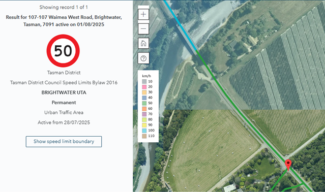
5.12.2 We propose that the speed signs are moved
to the eastern end of the bridge in line with the speed limits shown in the National
Speed Register.
5.12.3 Upper Moutere: Moutere Highway: In October
2024, the Moutere Hills Residents Association submitted a petition
a) to lower the speed on the Moutere
Highway to 80km/h,
b) to lower speeds in the village to 40km/h
and
c) install a pedestrian crossing near the
Upper Moutere School.
The speeds on
the Moutere Highway has since been reduced to 80km/h. However, staff initially
believed the new speed rule did not permit a 40km/h in the village so this was
not included in the consultation. Following further discussions with NZTA, it
appears the road may qualify as an “urban street with significant levels
of pedestrian and/or cycling activity” which could allow a future
reduction to 40km/h if supported by Council and subject to further
consultation.
5.12.4 Attachment 13 Phase
Three Corrections shows three corrections that need to be made in the National
Speed Limit Register. These are administrative changes and are for information
only.
5.12.5 Recommendation:
We recommend
proceeding with the proposed speed limit reductions in the Specific Roads table
above based on:
· Community feedback
· Current road use and design
· Alignment with national guidance and observed speeds.
5.13 Cost
by Ward
This table
includes all roads moved to this section from the Urban Roads without
Footpaths and Narrow/Winding Unsealed Roads categories.
|
Ward
|
Specific
Roads
Only
|
Plus
narrow and winding roads
|
Plus
urban roads with no footpaths
|
|
|
Golden
Bay
|
$40,000
|
$4,000
|
$7,000
|
|
|
Lakes
Murchison
|
$28,000
|
$0
|
0
|
|
|
Moutere Waimea
|
$40,000
|
$0
|
0
|
|
|
Motueka
|
$25,000
|
0
|
$8,000
|
|
|
Richmond
|
$11,000
|
$0
|
$1,000
|
|
|
Total
|
$144,000
|
$4,000
|
$16,000
|
$164,000
|
6. Financial
or Budgetary Implications / Ngā Ritenga ā-Pūtea
6.1 The Tasman District Council Long Term
Plan 2024-2034 provides budget for the implementation of the Speed Management
Plan. The annual budgets are $250,000 per annum. $210,000 is available from
NZTA for 2024/2025 and 2025/2026 toward speed limit changes around schools.
6.2 Phase One and Phase Two Speed reductions
will be over four years (Years One to Four) and are forecast to cost $800,000.
No annual year budget will be exceeded.
6.3 Phase Two funding will come from the
2026/2027 and 2027/2028 years.
6.4 The budgets also allow for future safety
improvements from 2028 onwards such as electronic variable signs around schools
or threshold treatments.
|
|
Option One
All
Changes
|
Option Two
Recommend by staff
Rural Residential & Specific Roads & small number of narrow
windy & urban roads with no footpath reduced (+advisory signs for all
other roads)
|
Option Three
Rural
Residential & Specific Roads (+ advisory signs for all other roads)
|
Option Four
No
changes
|
|
Narrow/Windy
Unsealed
|
$85,000
|
$48,000
|
$46,000
|
0
|
|
Rural
Residential
|
$120,000
|
$120,000
|
$120,000
|
0
|
|
Urban
Road No Footpath
|
$44,000
|
$31,000
|
$36,000
|
0
|
|
Specific
Roads
|
$144,000
|
$164,000
|
$144,000
|
0
|
|
Total
|
$393,000
|
$363,000
|
$346,000
|
0
|
6.5 Implementation would be over two years
and set for the 2026/2027 and 2027/2028 years.
7.1 The Council consulted on four types of
roads:
• Narrow
or winding tortuous unsealed roads reduced to 60km/h
• Rural
residential roads and peri-urban streets reduced to 50-60km/h
• Urban
roads which do not have footpaths reduced to 40km/h
• Specific
roads
7.2 The Council has several options: it can
reduce speeds on all roads in each category, make changes to selected roads, or
choose not to make any changes at all.
7.3 Below shows the high level options
available
|
Option
|
Advantage
|
Disadvantage
|
|
1.
|
All speed limit reductions are adopted
|
Reduces crash risk and harm
Enables rollout from 2026.
Avoids the need for further consultation
and cost benefit analysis
Aligns with 2024 Council decision
Consistent approach to narrow/windy
unsealed roads or to urban roads without footpaths.
|
May not satisfy submitters who opposed
changes
Highest cost
|
|
2.
|
Adopt some changes
[Recommended Option]
· Rural Residential Roads and Specific roads
· Four selected Narrow & Windy Unsealed Roads
(see Section 5.5.7)
· 15 selected Urban Roads with No Footpaths
(see Section 5.7.4)
· Use Advisory signs elsewhere
|
Responds to community concerns for speeds
limits in rural residential areas and specific areas
Consistent approach to rural residential
areas
Targets the specific roads with safety
risks (e.g. recreational areas, high crash rates, presence of cyclists)
Balances safety improvements and cost
savings
Advisory signs don’t require NZTA
certification
|
May require future consultation for roads
not changed now
Partial crash reduction now
May not satisfy all submitters
Inconsistent treatment across similar
road types
|
|
3
|
Rural residential and Specific Roads
only
|
Consistent approach to rural residential
areas
Addresses community concerns in key areas
Some crash reduction
Lower cost
Advisory signs don’t require NZTA
certification
|
Leaves out known risk roads (e.g.
unsealed roads)
Inconsistent approach
Some benefits not achieved
May not satisfy all submitters
May require future consultation for roads
not changed now
|
|
4
|
No proposals are adopted
|
May satisfy those opposed to reductions
No cost to implement
|
No safety improvement
Fails to address community concerns
Would require rework and re-consultation
for future changes
May not satisfy submitters who support
specific speed limit reductions.
Significant staff resources have already
been invested in this work.
|
7.4 Option 2 is recommended as it balances a
cost-effective response to safety and community concerns.
8.1 All proposed speed changes align with
the Setting of Speed Setting Rule 2024, with three exceptions –Inlet Road
(30km/h) Community Road (30km/h) and Tapu Place (40km/h) where reductions are
consistent with existing surrounding speed limits. They would not result in any
additional cost to the Council.
9. Iwi
Engagement / Whakawhitiwhiti ā-Hapori Māori
9.1 Staff engaged with Ngāti Tama, Te Ātiawa and Ngāti
Rārua in February 2025 and
have regularly updated the engagement portal. During the first consultation
phase in 2023-24, the speed management process was discussed at hui, and
feedback sought. It is now proposed additional signage will be used on
Pōhara Valley Road close to the marae rather than a speed reduction
originally proposed on Falconer Road.
10. Significance
and Engagement / Hiranga me te Whakawhitiwhiti ā-Hapori Whānui
10.1 Consultation has followed the requirements of the
Setting of the Speed Limits Rule 2024 (S3.8). The Council has consulted on each
proposed speed limit change and made reasonable efforts to engage with road
users, local communities, businesses on the affected roads and schools. This
Rule does not require consultation under section 83 of the Local Government Act
2002.
|
|
Issue
|
Level of
Significance
|
Explanation of
Assessment
|
|
1.
|
Is there a high level
of public interest, or is decision likely to be controversial?
|
High
|
Many people are
passionate about speed limit changes (for and against).
|
|
2.
|
Are there impacts on
the social, economic, environmental or cultural aspects of well-being of the
community in the present or future?
|
|
The proposed
reductions aim to improve safety on rural residential, unsealed, and urban
roads without footpaths, and on roads raised as concerns by the community.
|
|
3.
|
Is there a
significant impact arising from duration of the effects from the decision?
|
No
|
|
|
4.
|
Does the decision
relate to a strategic asset? (refer Significance and Engagement Policy for
list of strategic assets)
|
Low
|
The transport system
as a whole is a strategic asset. These changes affect a small proportion of
the system and have been subject to comprehensive consultation.
|
|
5.
|
Does the decision
create a substantial change in the level of service provided by Council?
|
No
|
|
|
6.
|
Does the proposal,
activity or decision substantially affect debt, rates or Council finances in
any one year or more of the LTP?
|
No
|
|
|
7.
|
Does the decision
involve the sale of a substantial proportion or controlling interest in a CCO
or CCTO?
|
No
|
|
|
8.
|
Does the
proposal or decision involve entry into a private sector partnership or
contract to carry out the deliver on any Council group of activities?
|
No
|
|
|
9.
|
Does the proposal or
decision involve Council exiting from or entering into a group of
activities?
|
No
|
|
|
10.
|
Does the proposal
require particular consideration of the obligations of Te Mana O Te Wai
(TMOTW) relating to freshwater or particular consideration of current
legislation relating to water supply, wastewater and stormwater
infrastructure and services?
|
No
|
|
11. Communication
/ Whakawhitiwhiti Kōrero
11.1 Consultation ran for six weeks from 9 June 2025 to
21 July 2025. We received 236 responses. An article was published in Newsline,
which is delivered across the Tasman District. Posts were also shared on
Facebook and information was made available on the Shape Tasman website.
11.2 Earlier consultation took place from 29 November
2023 and 29 February 2024 during which 2247 submissions were received.
12.1 If these speed limit reductions are not
implemented, Tasman District may continue to fall short of the safety
performance objectives in the Regional Land Transport Plan. These objectives
include reducing the number and proportion of deaths and serious injuries from
crashes.
12.2 There is a political risk that some community
members - whether for or against the changes - may be dissatisfied with the
Council’s decision.
12.3 Staff are aware of a Judicial Review filed in the
High Court challenging the Setting of Speed Limits Rule 2024. The applicant
sought to overturn the 2024 Rule and reinstate the 2022 version in the interim.
The High Court dismissed the interim injunction application in April 2025. The
substantive judicial review remains active, with no final decision yet. As
Tasman’s proposed speed limit reductions generally align with both the
2022 and 2024 Rules, the outcome of the review is expected to have minimal
impact on the proposed changes.
13. Climate
Change Considerations / Whakaaro
Whakaaweawe Āhuarangi
13.1 The
proposed speed limit reductions are expected to have minimal impact on climate
change overall.
13.2 However,
reducing rural speed limits from 100km/h may lead to lower fuel consumption,
and the 2024 cost benefit analysis shows this would contribute to a reduction
in greenhouse gas emissions.
14. Alignment
with Policy and Strategic Plans / Te Hangai ki ngā aupapa Here me ngā
Mahere Rautaki Tūraru
14.1 The proposed speed limit reductions support the
objective in the Regional Land Transport Plan that all communities have access
to a safe transport system regardless of mode.
15. Conclusion
/ Kupu Whakatepe
15.1 The
consultation received feedback from 236 individuals
15.2 Staff
have considered this feedback along with input from the 2023/24 consultation. We propose speed limit reductions on rural residential roads,
specific urban roads without footpaths, and narrow or winding roads identified
by the community.
15.3 These speed limit changes are a practical
and cost-effective way to make roads safer, using the approach allowed under
the new Speed Rule. The speed limit reductions present a pragmatic way to
improve road safety outcomes through safer speeds within the framework
allowable under the new Speed Rule
16. Next
Steps and Timeline / Ngā Mahi Whai Ake
16.1 Staff will submit the list of roads with speed limit changes to NZTA
for certification.
16.2 Once certified, staff will proceed with implementation (July 2026
onwards).
|
1.⇩
|
Schedule
1: Phase Two Reductions
|
477
|
|
2.⇩
|
Advisory
Signs List
|
499
|
|
3.⇩
|
Phase 2
Feedback 2024 to 2025 Consultations
|
503
|
|
4.⇩
|
Phase 2 -
Verbatim Feedback
|
521
|
|
5.⇩
|
Phase 2 -
Motueka Communitiy Board Submission
|
553
|
|
6.⇩
|
Phase 2 -
Transporting NZ submission
|
554
|
|
7.⇩
|
Phase 2 -
Consultation Material
|
562
|
|
8.⇩
|
Phase 2 -
Golden Bay Map Book
|
572
|
|
9.⇩
|
Phase 2 -
Lakes-Murchison Map Book
|
609
|
|
10.⇩
|
Phase 2 -
Motueka Map Book
|
627
|
|
11.⇩
|
Phase 2 -
Moutere Waimea Map Book
|
648
|
|
12.⇩
|
Phase 2 -
Richmond Map Book
|
681
|
|
13.⇩
|
Phase 2 -
Corrections
|
693
|
Tasman District
Council
Agenda – 14 August 2025


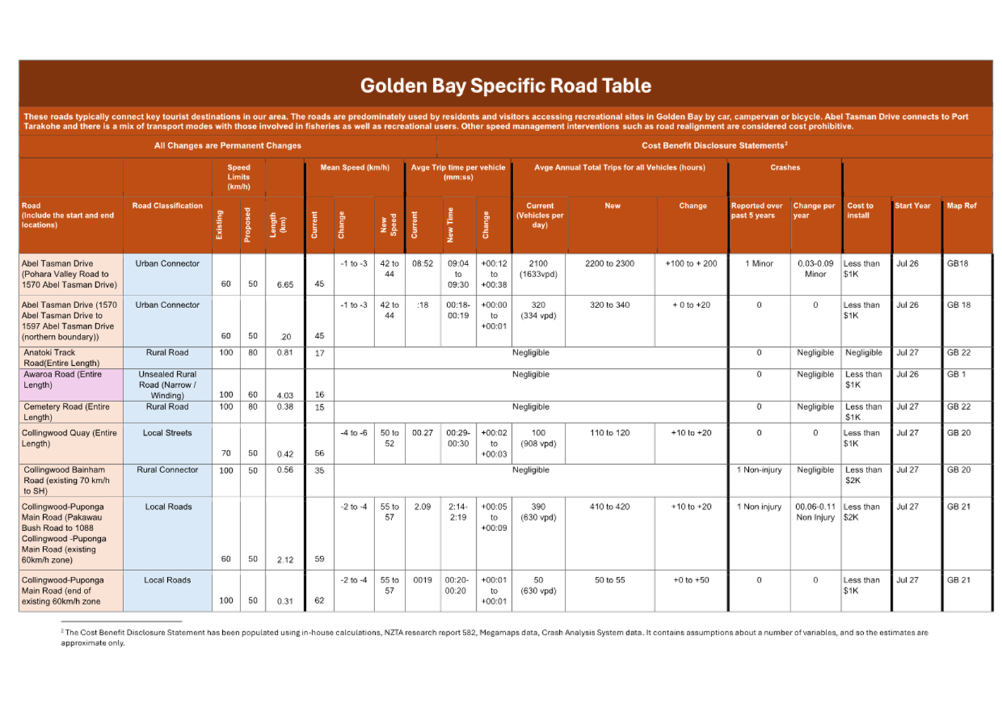
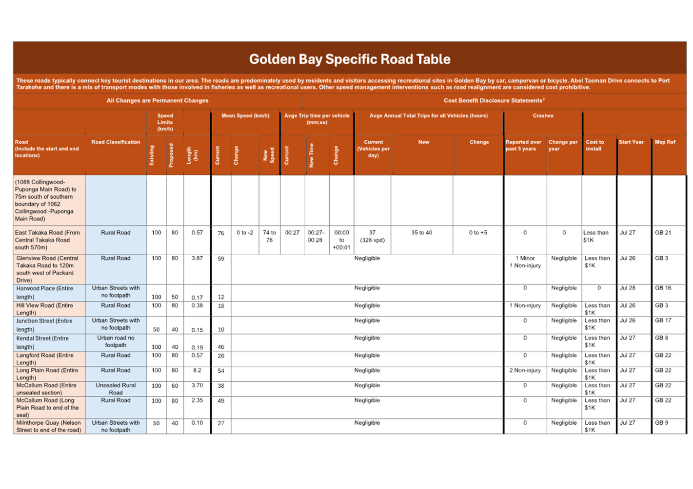
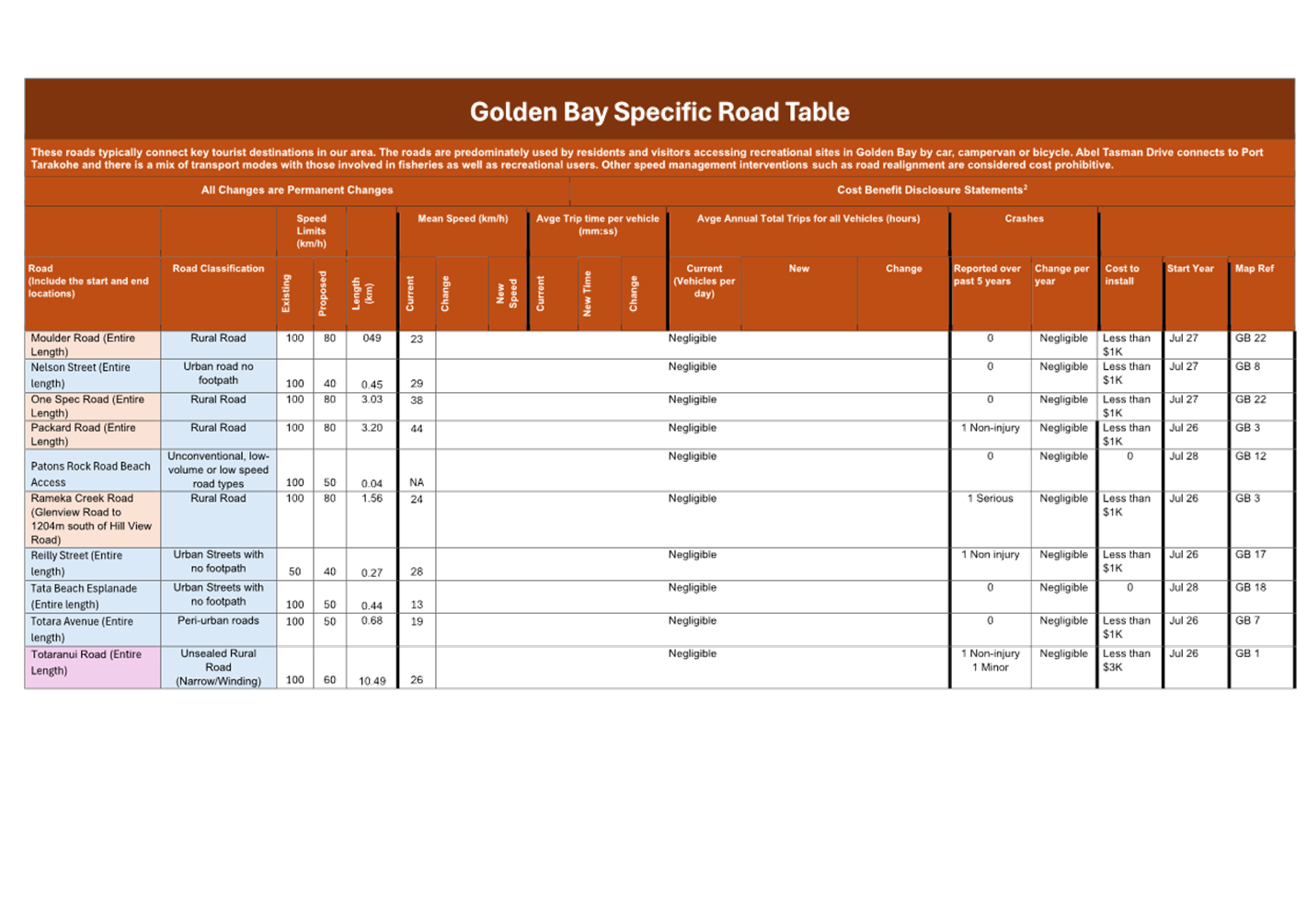
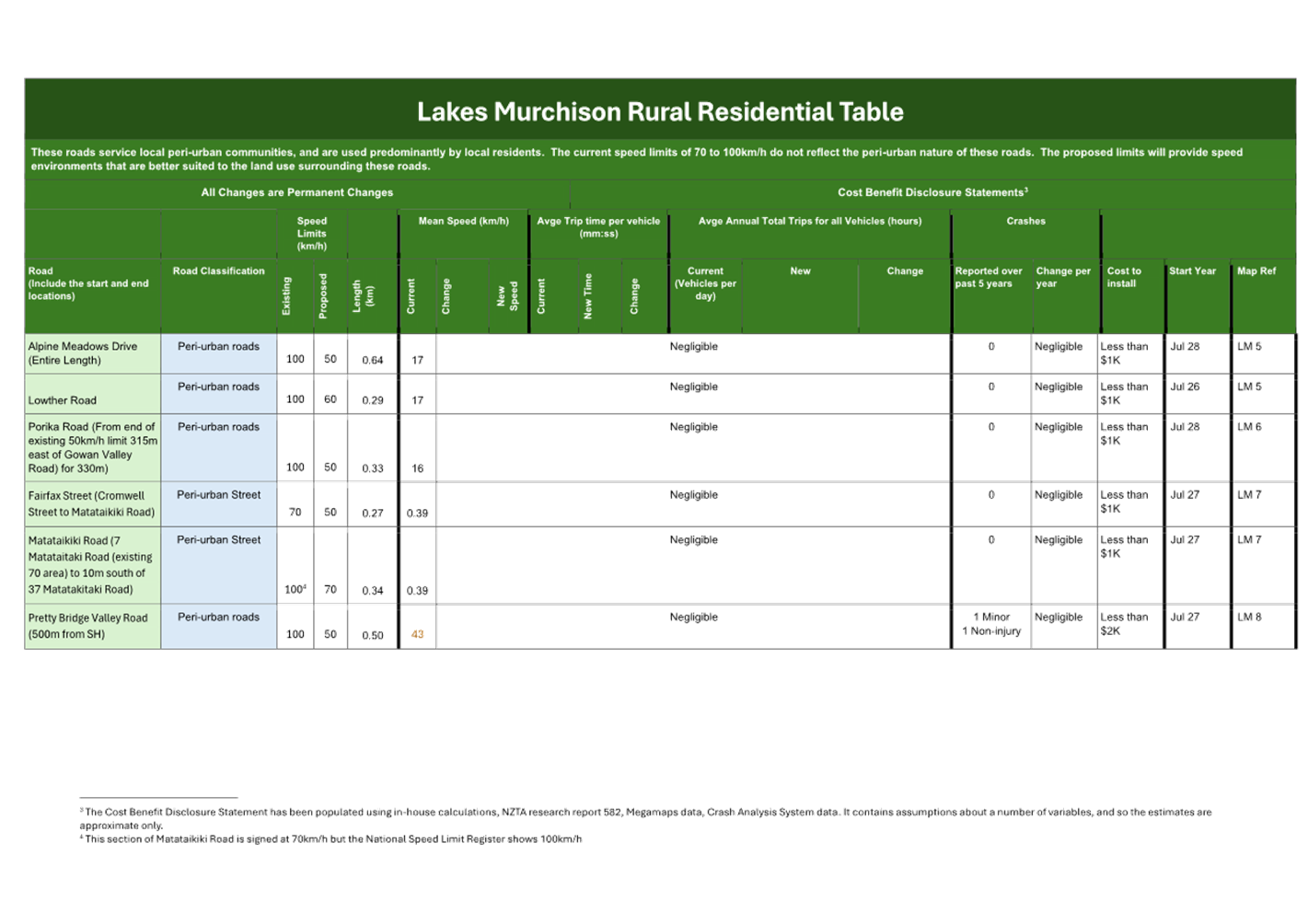
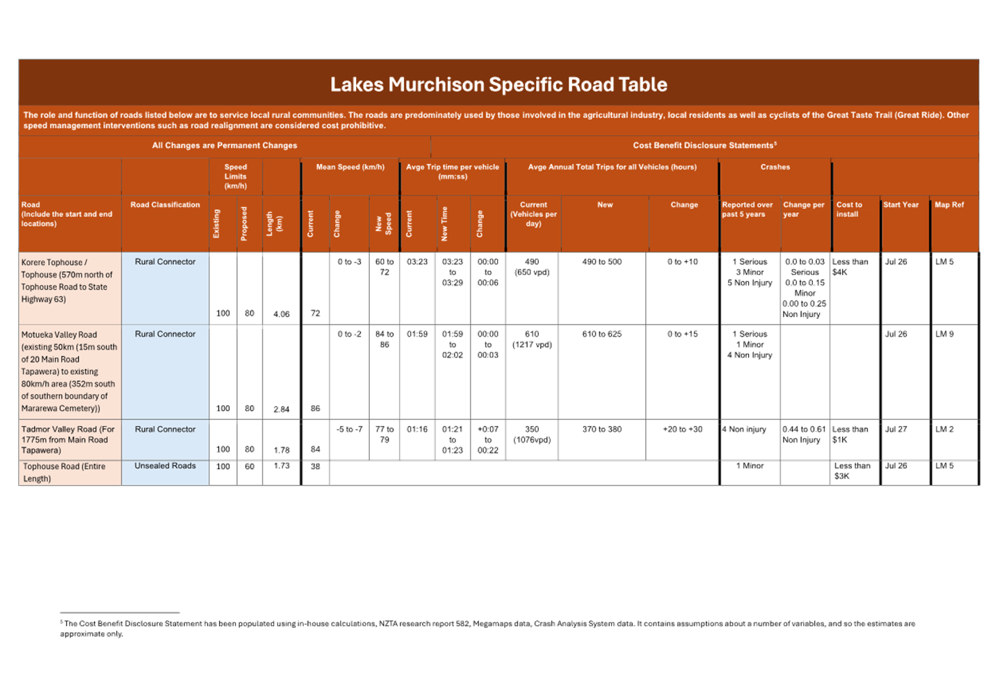
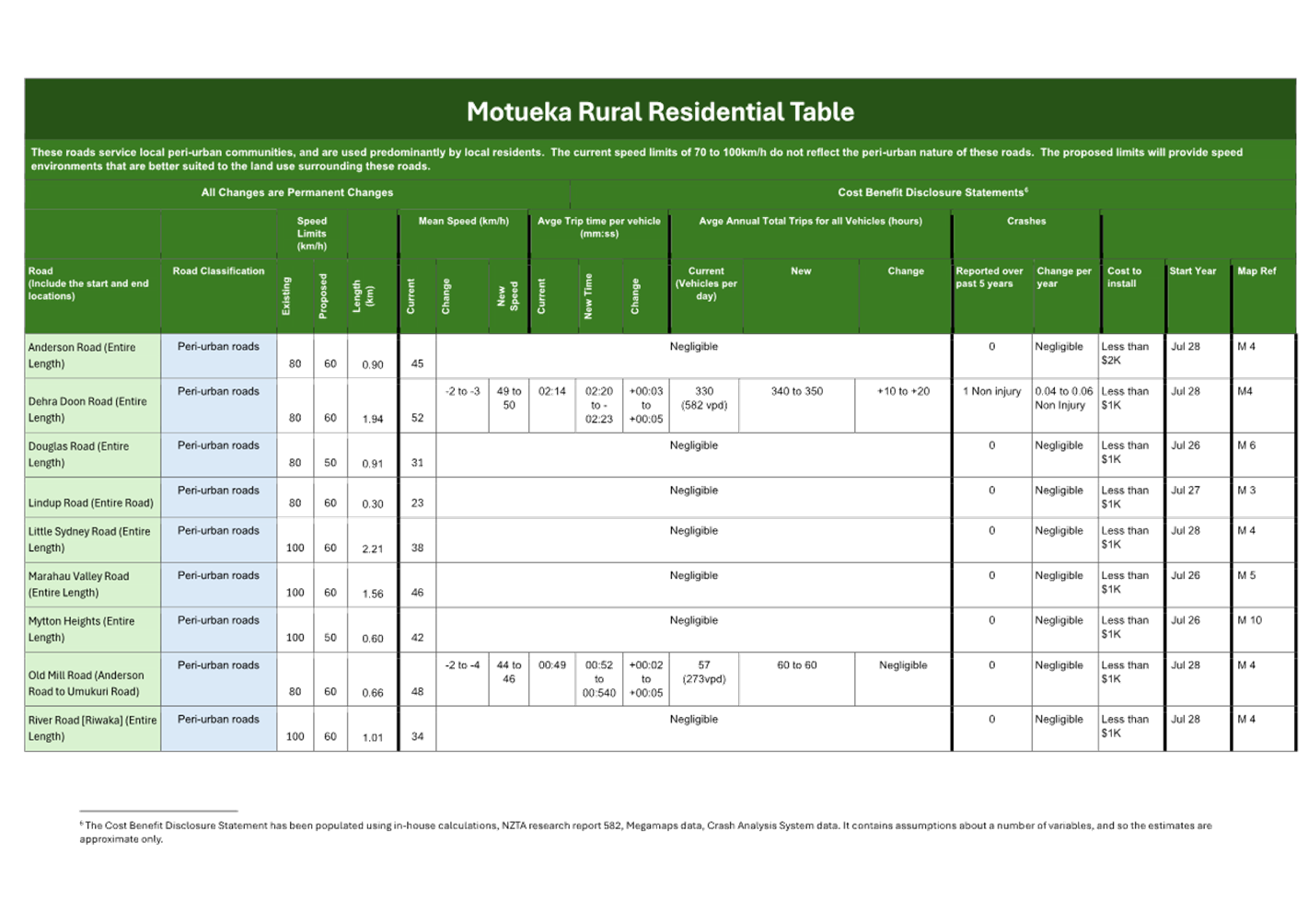
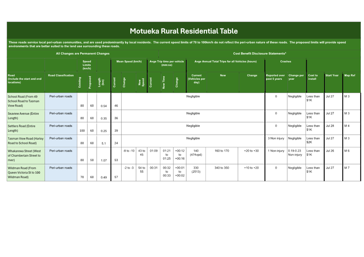
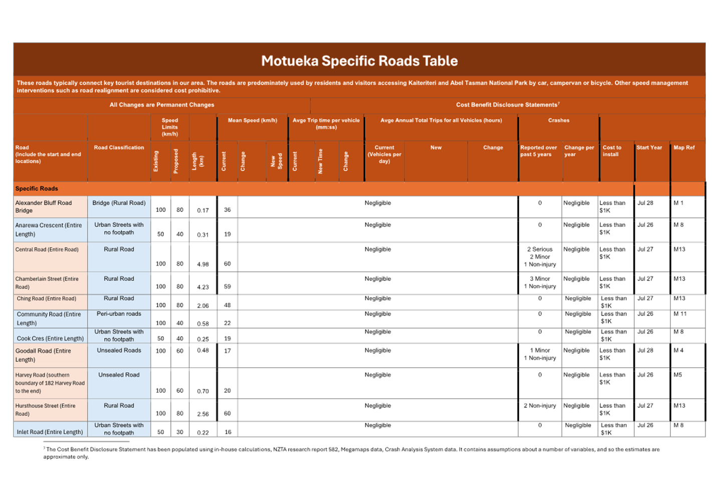
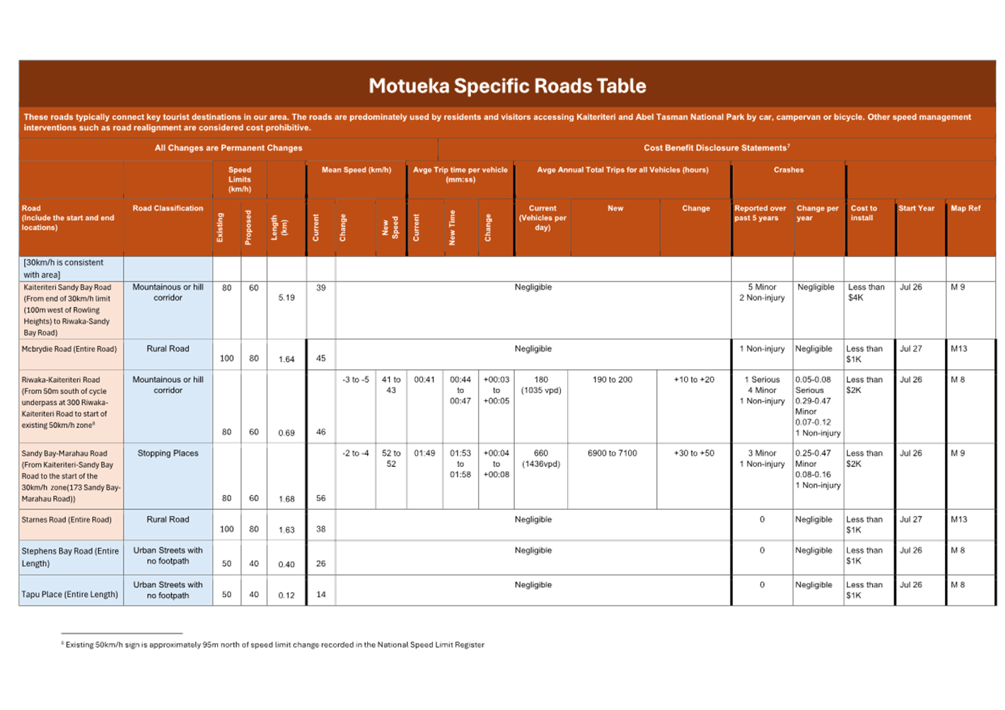
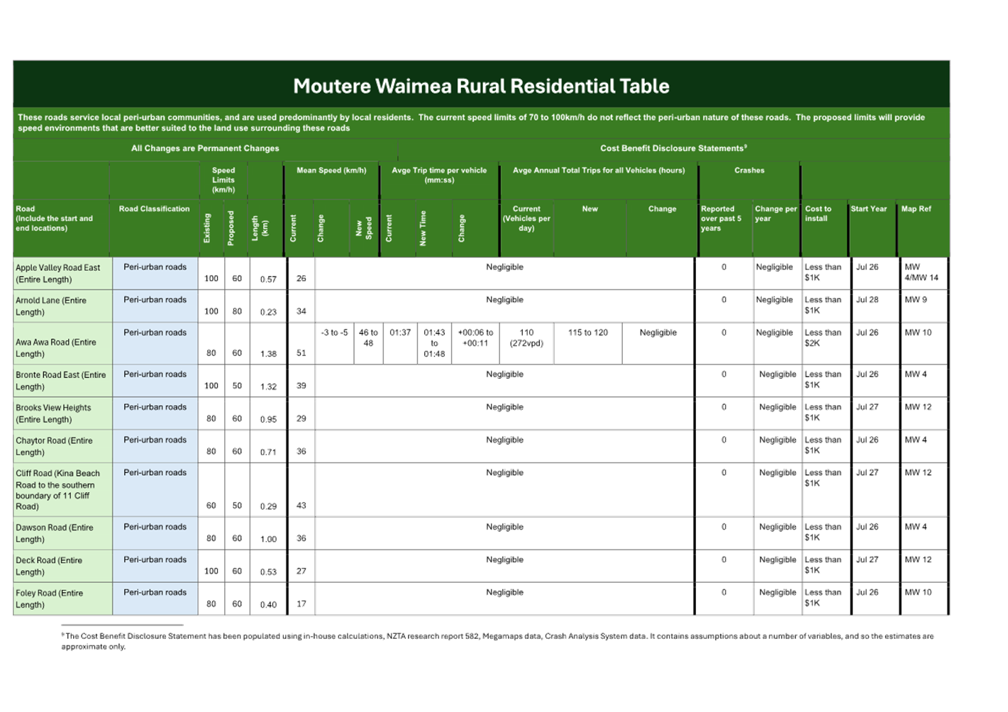
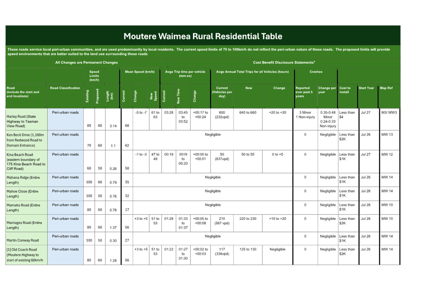
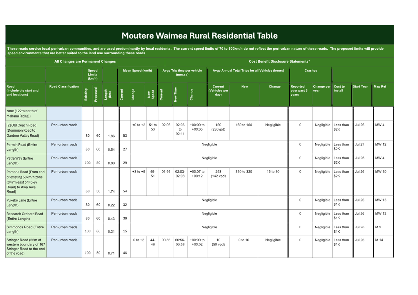
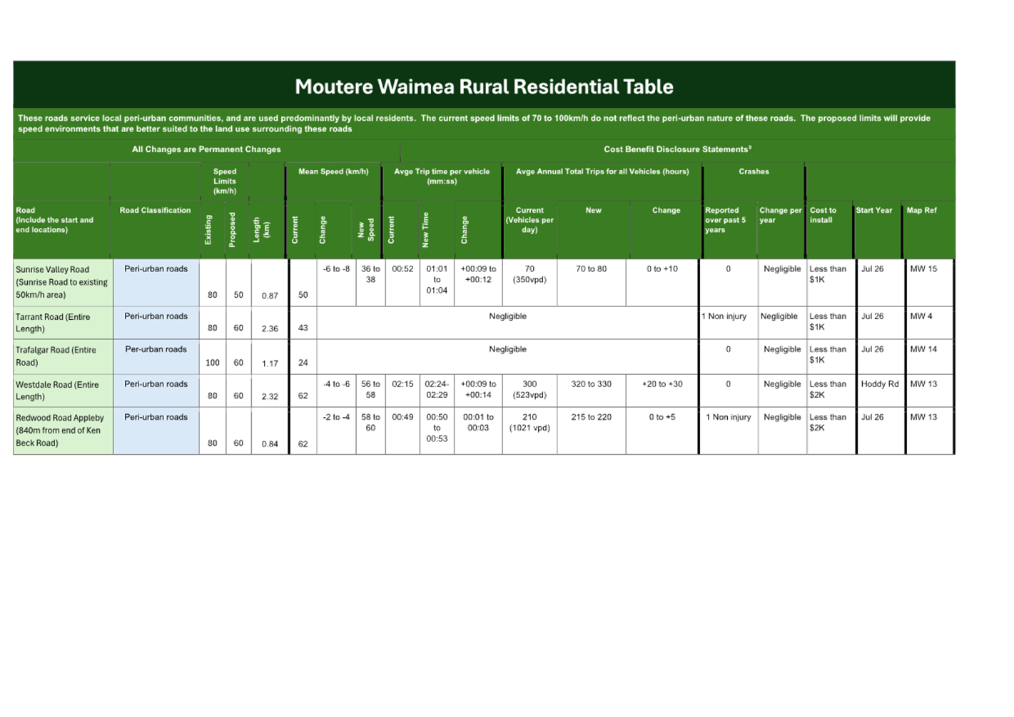
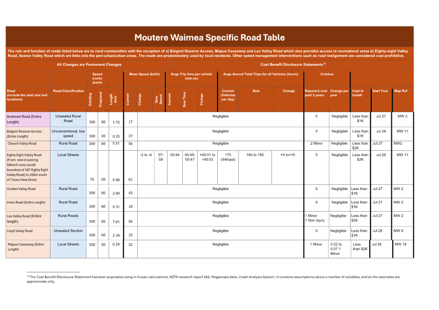
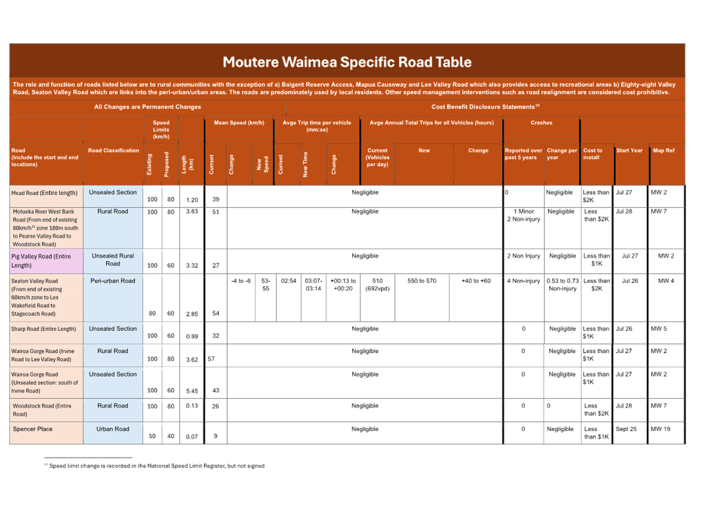
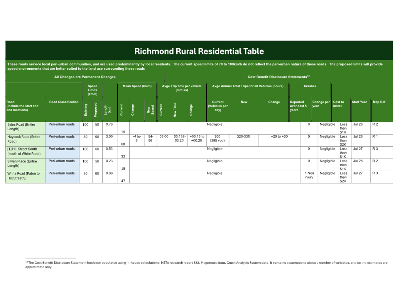
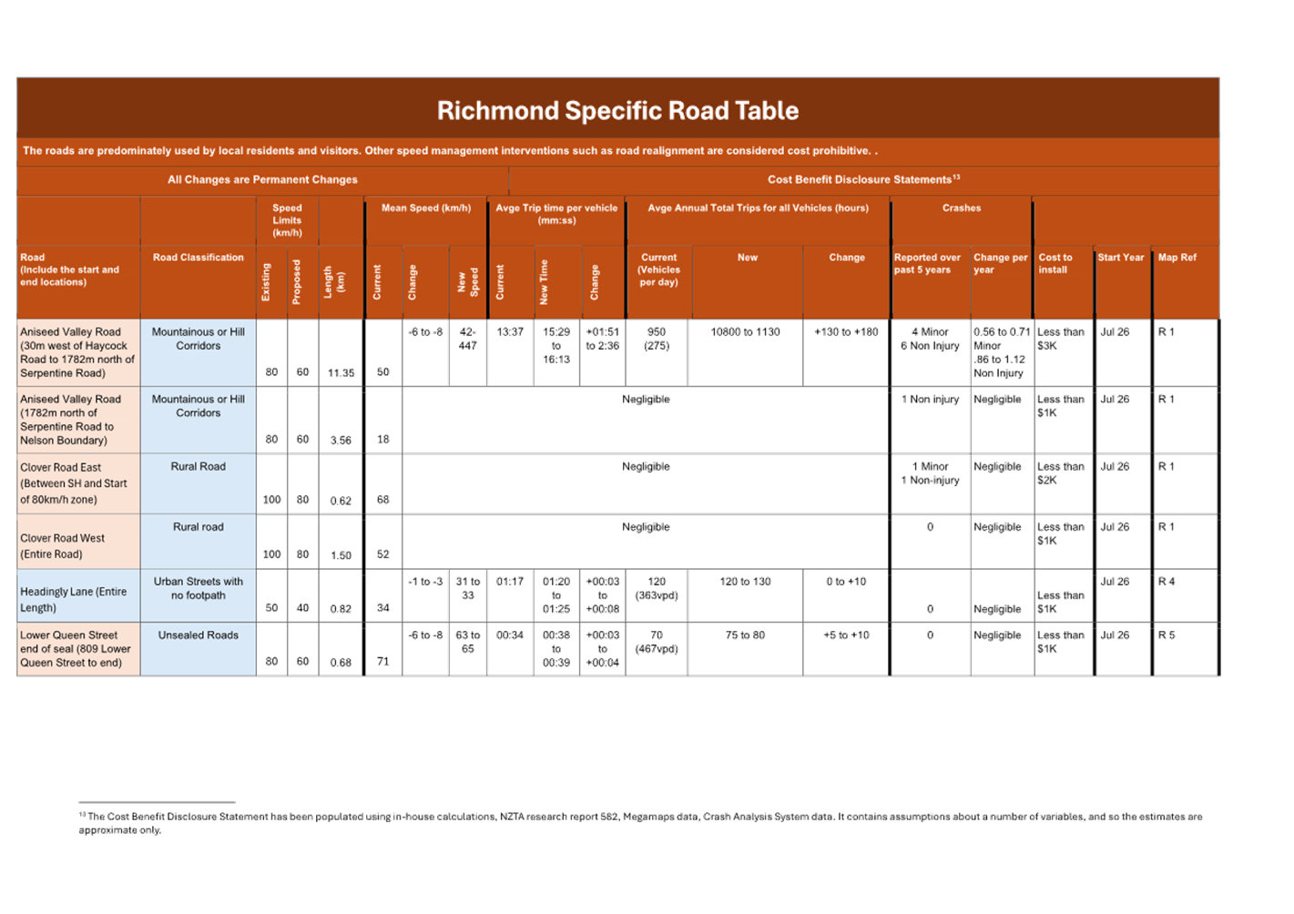
Tasman District Council Agenda – 14 August 2025
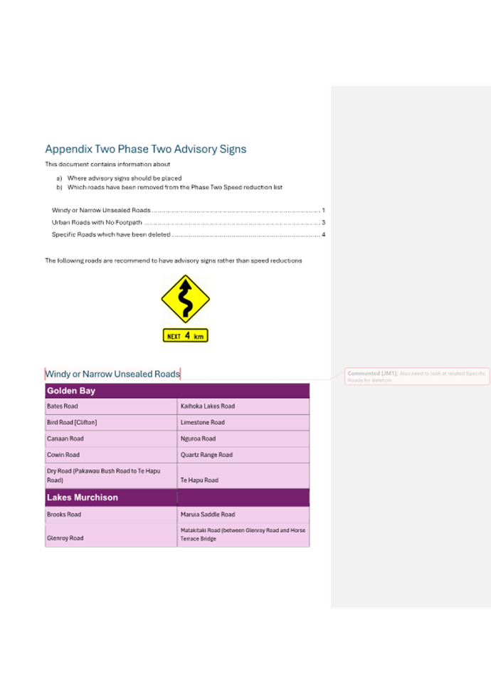
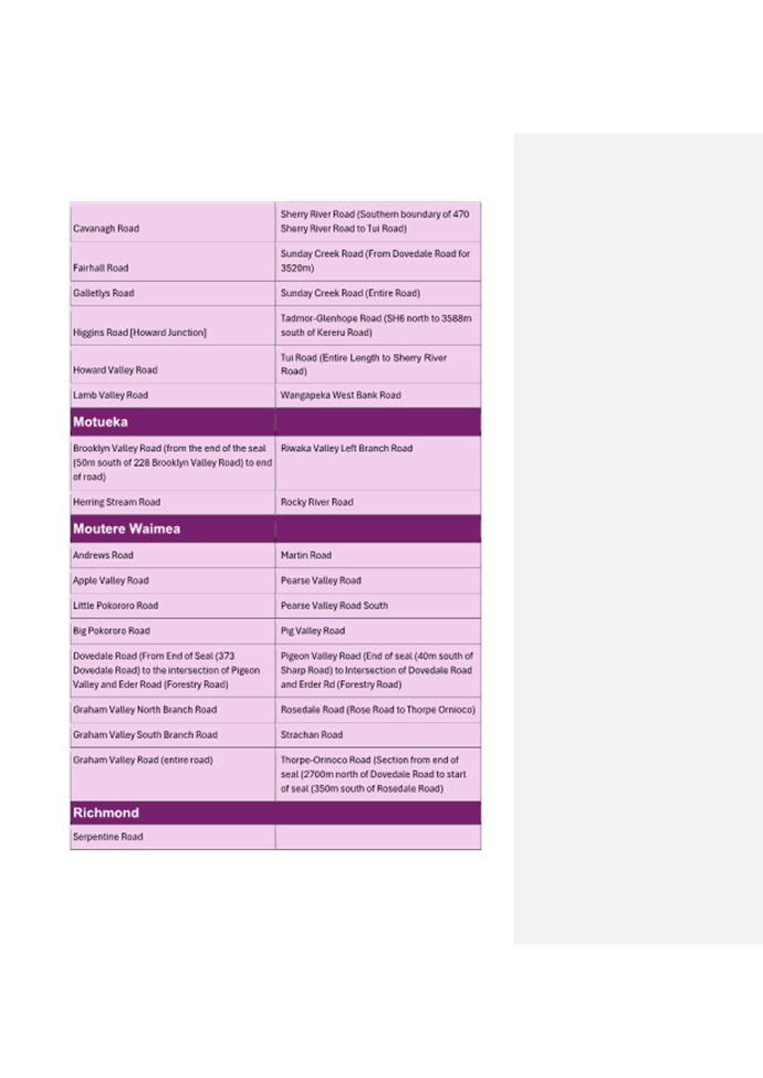
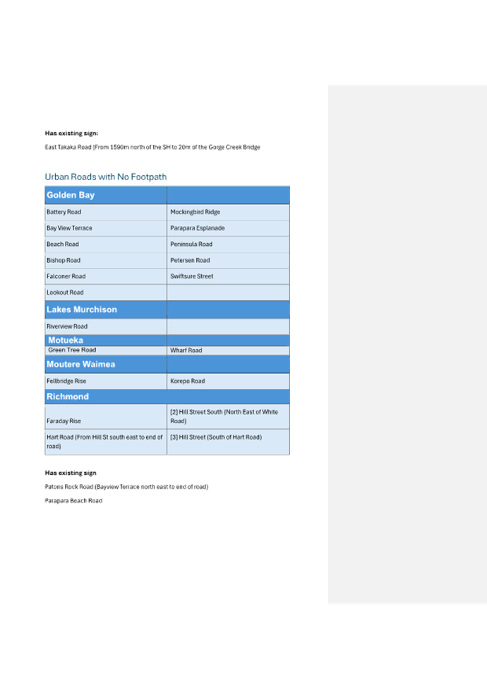
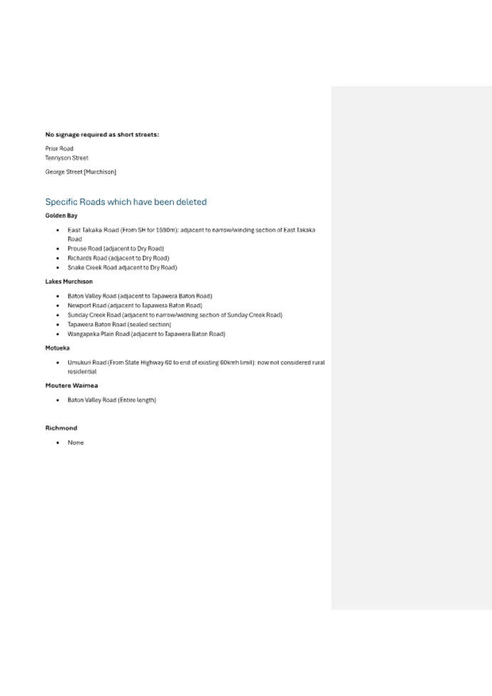
Tasman District Council Agenda – 14 August 2025
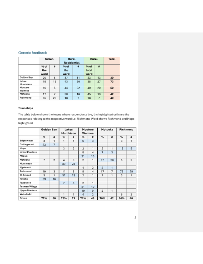
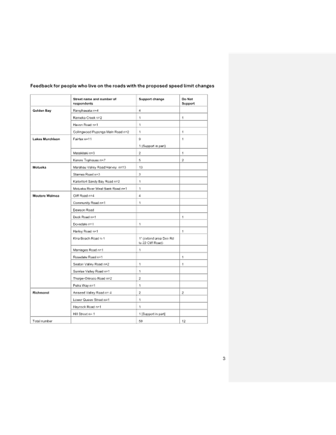
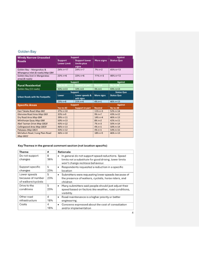
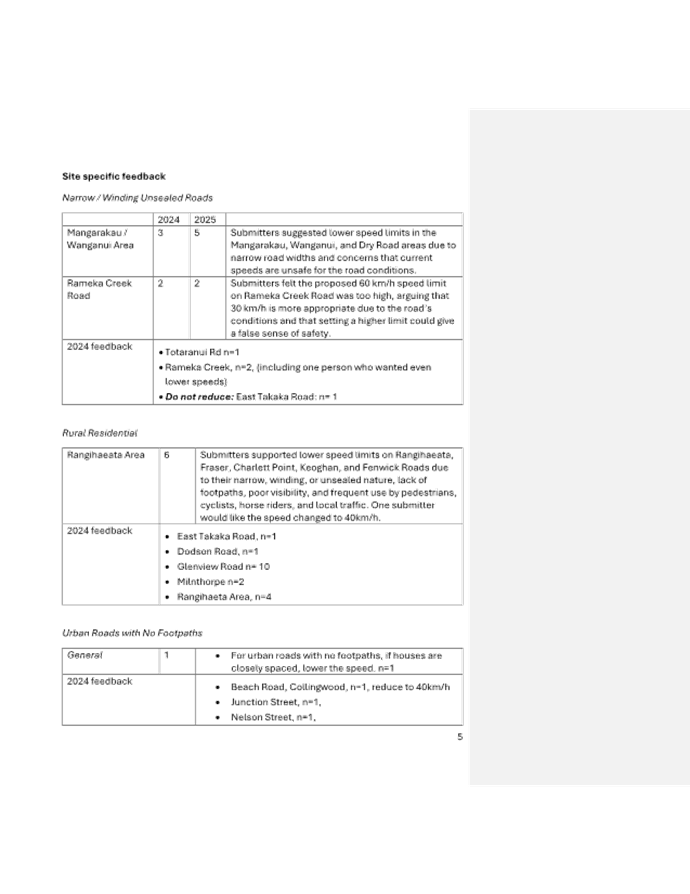
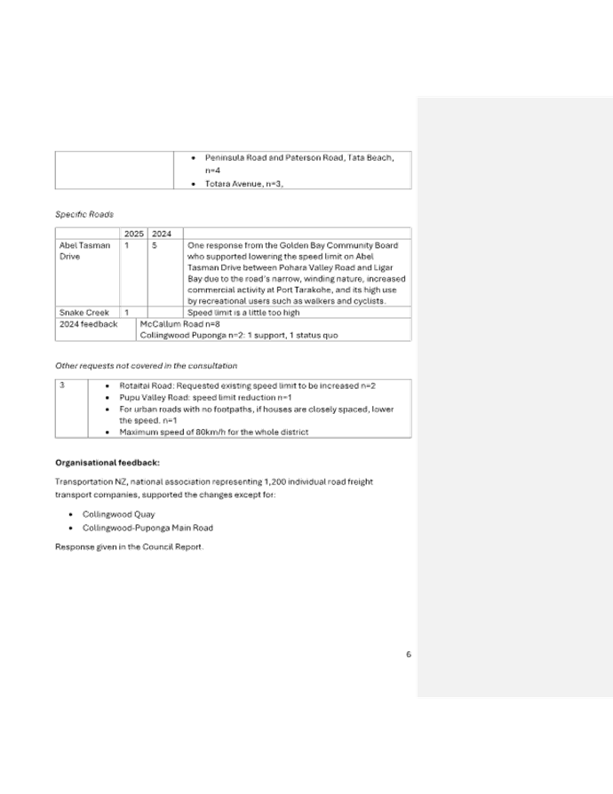
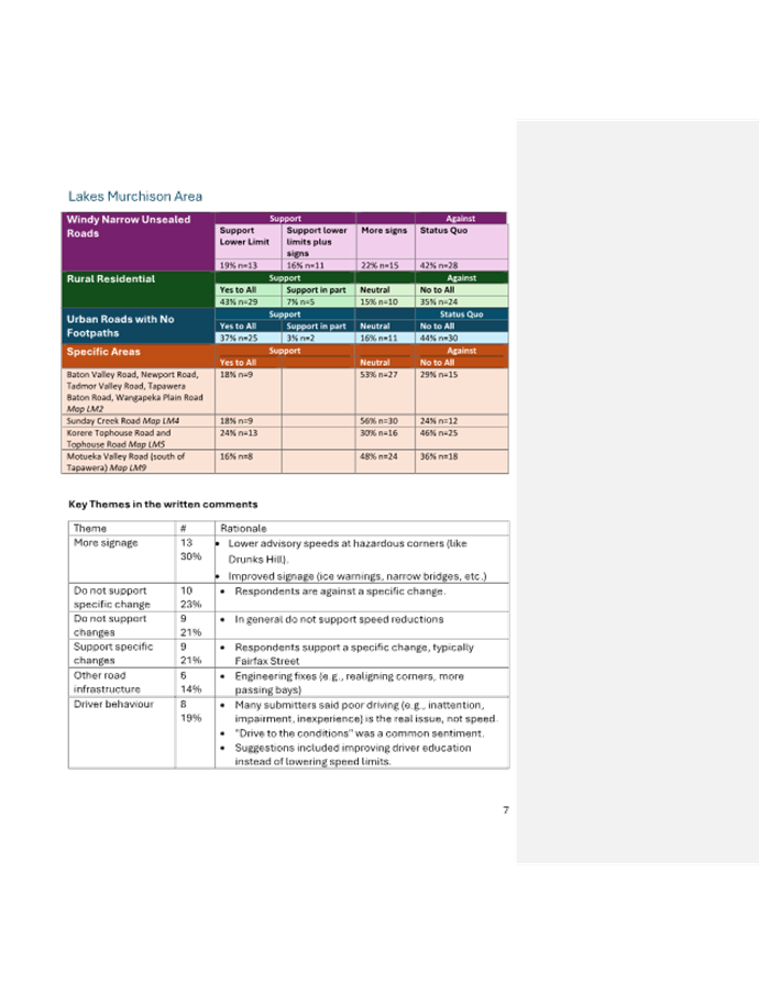
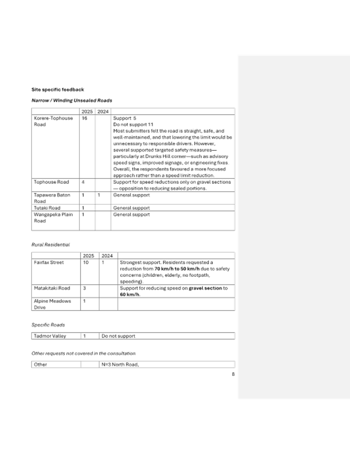
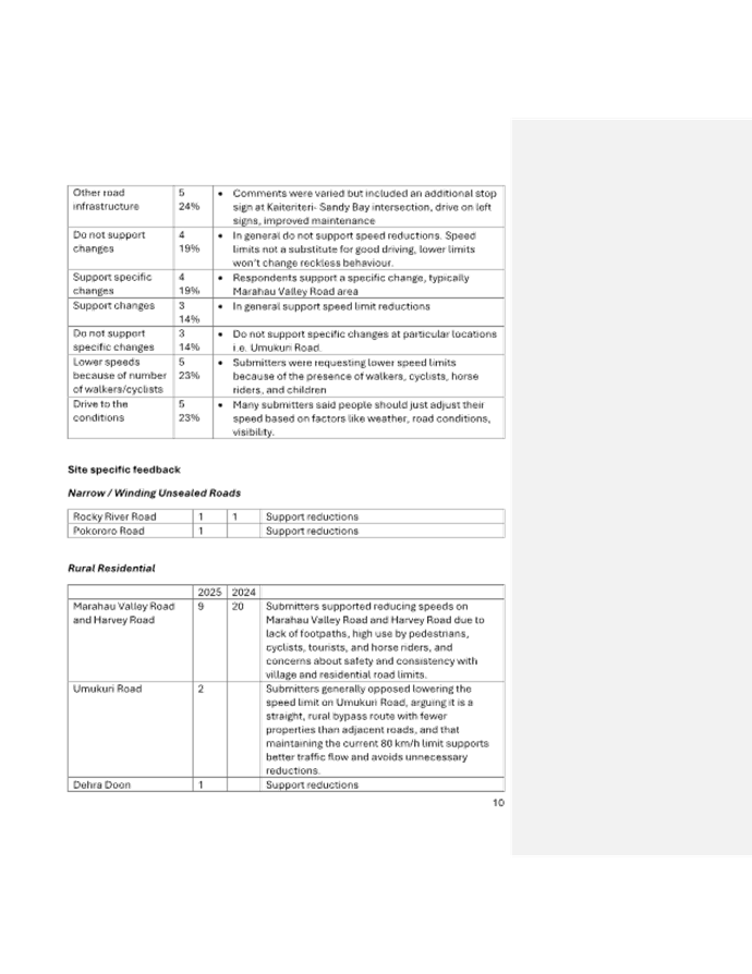
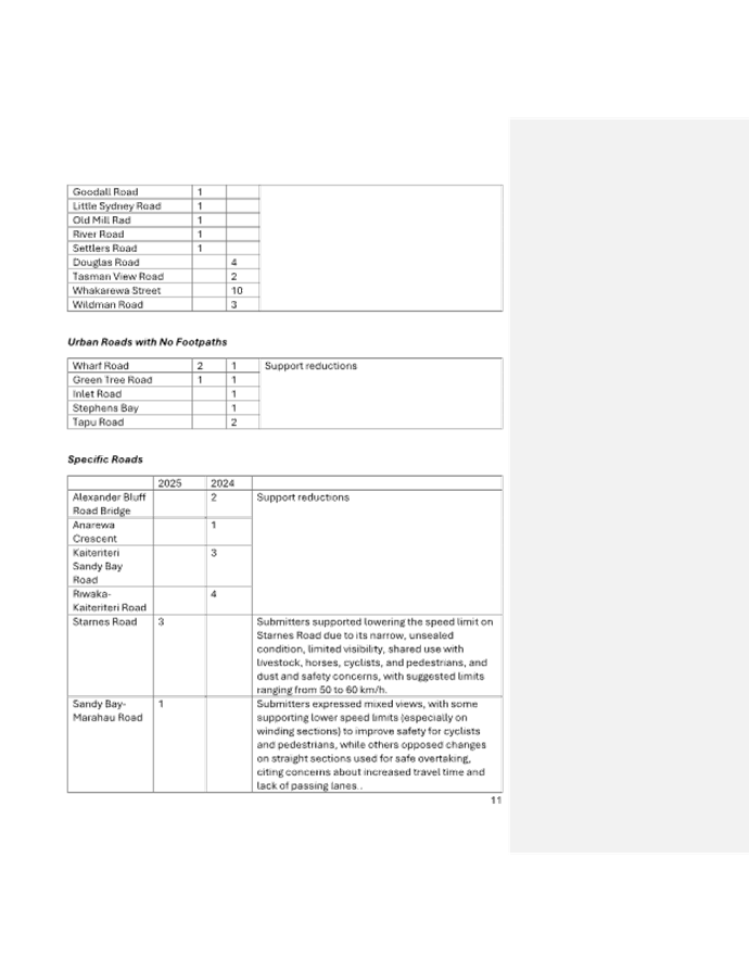
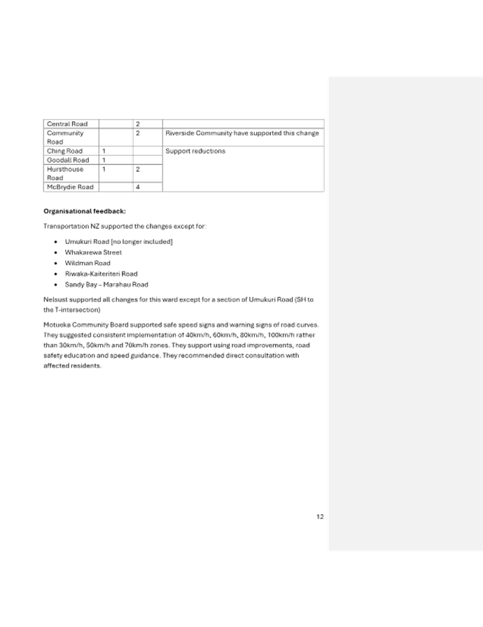
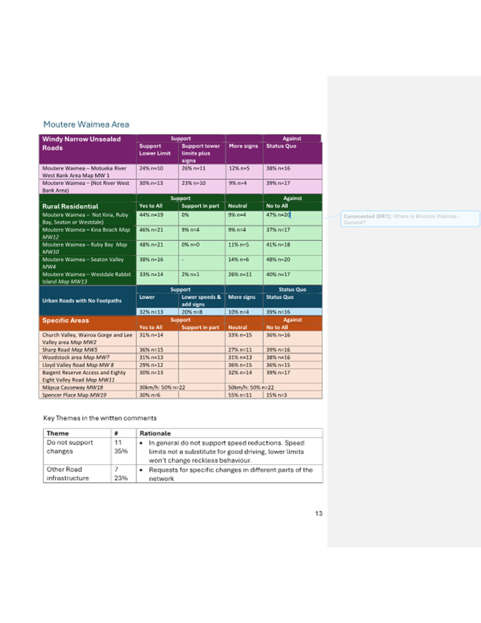
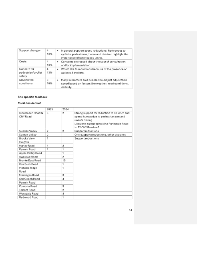
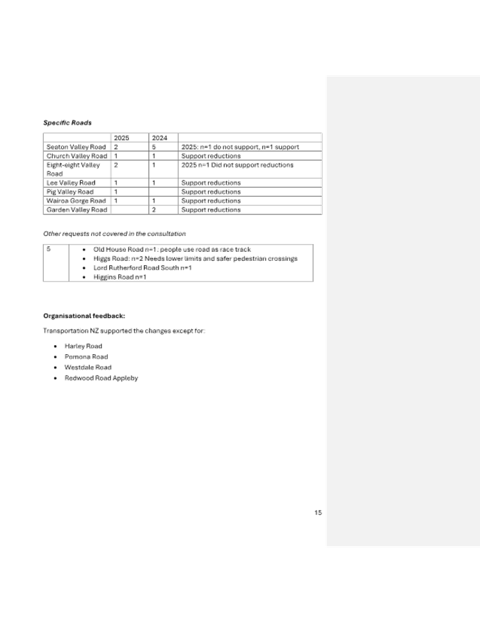
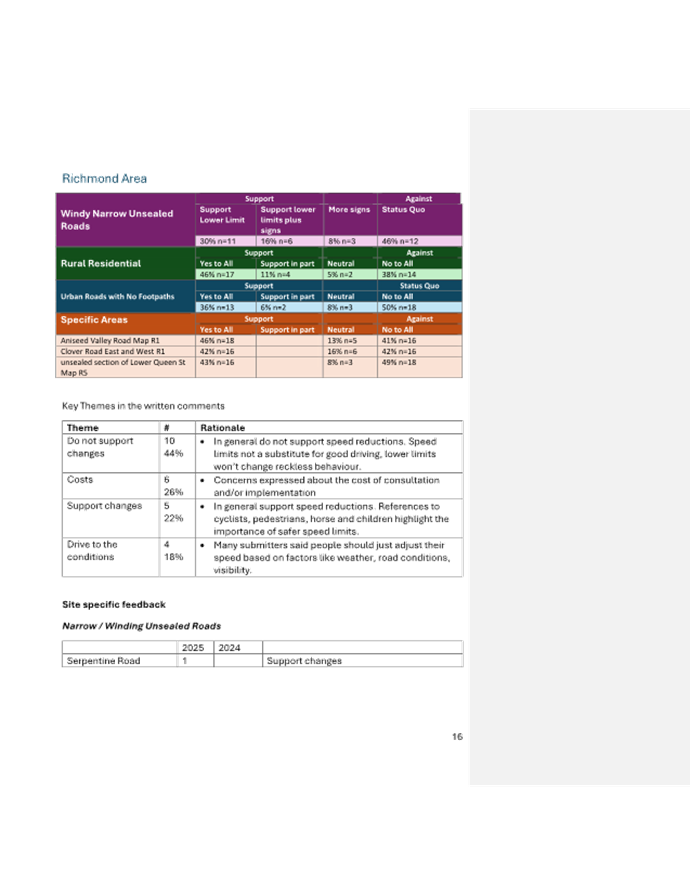
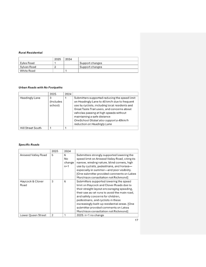
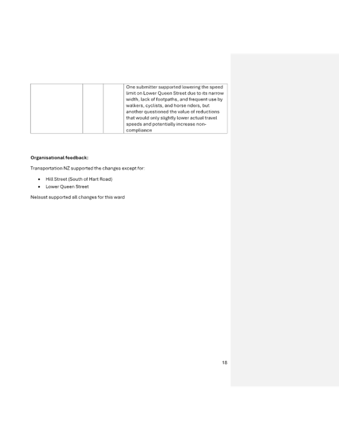
Tasman District Council Agenda – 14 August 2025
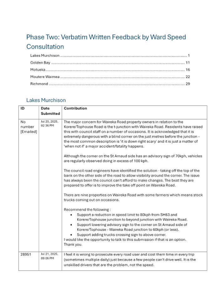
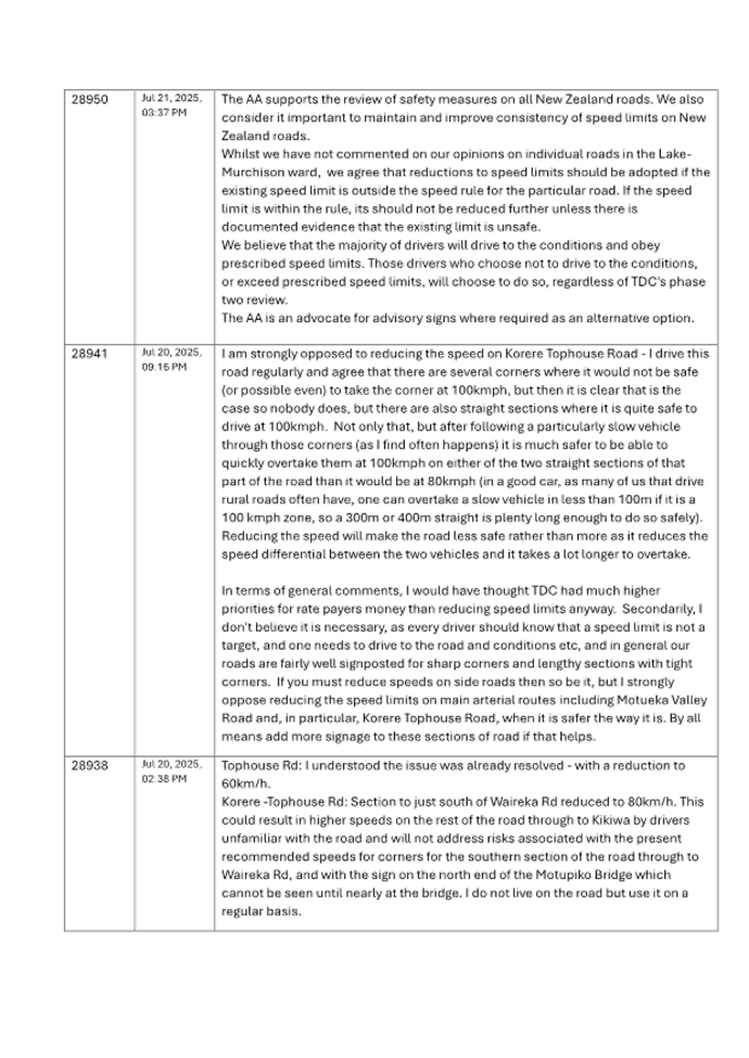
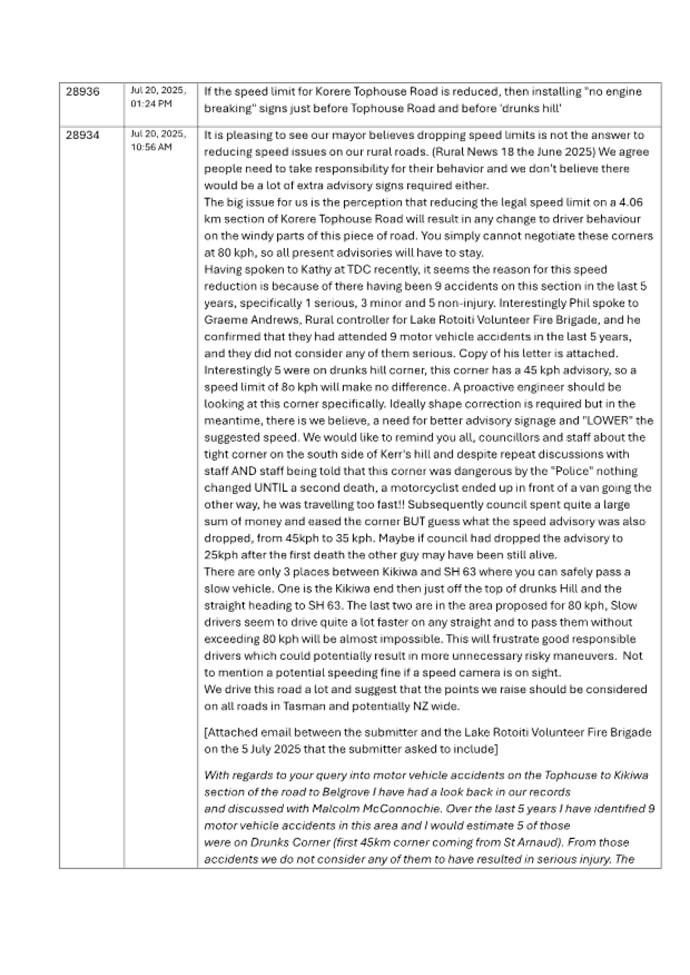
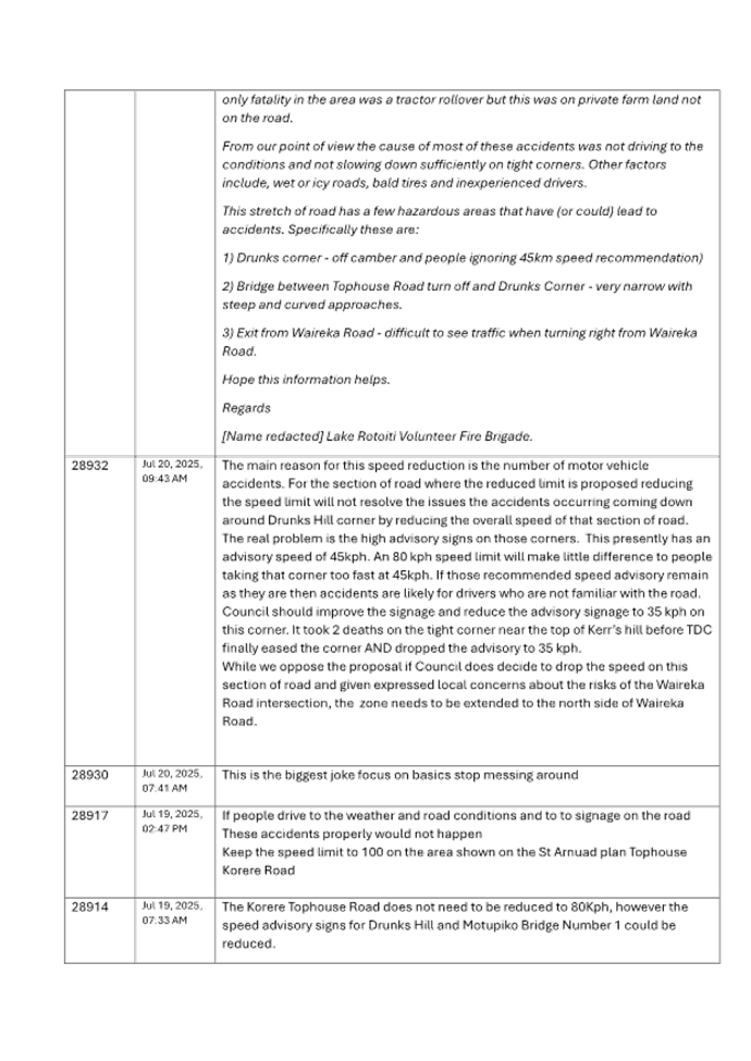
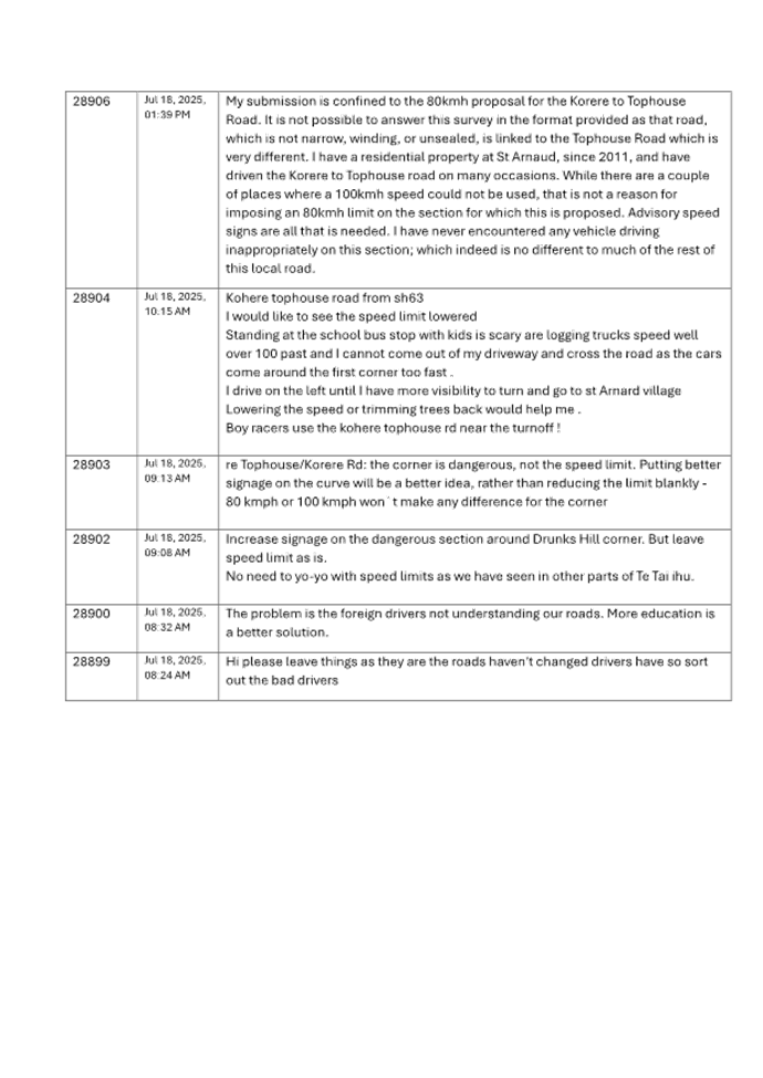
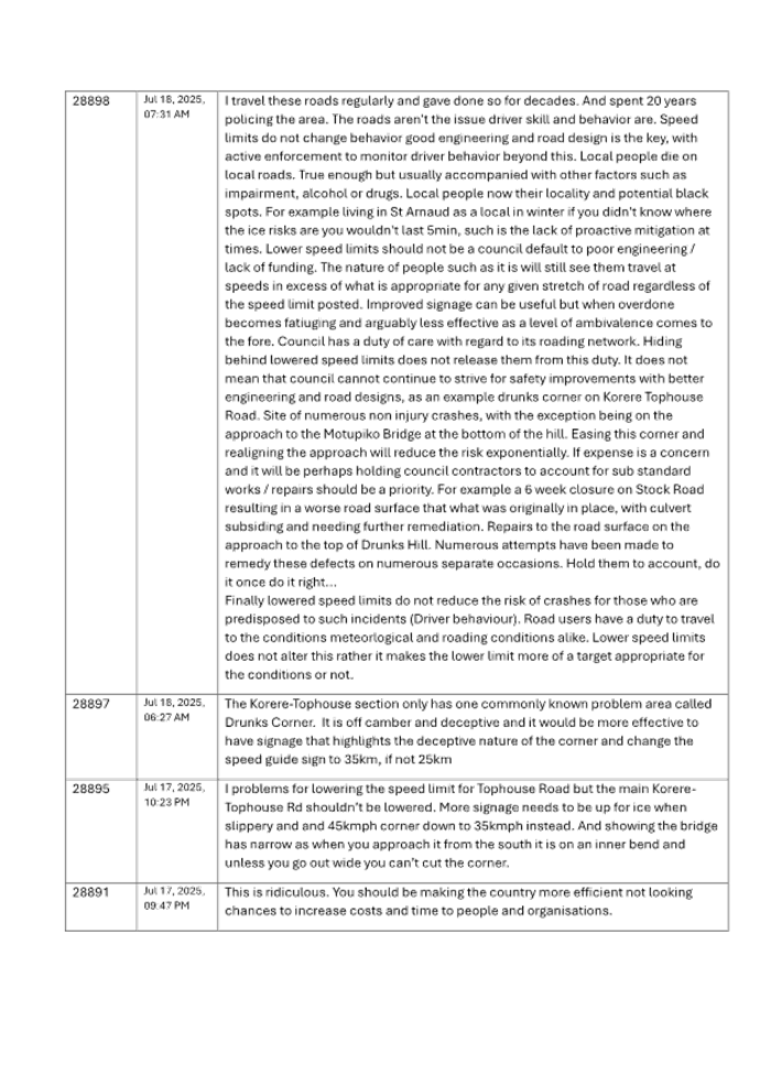
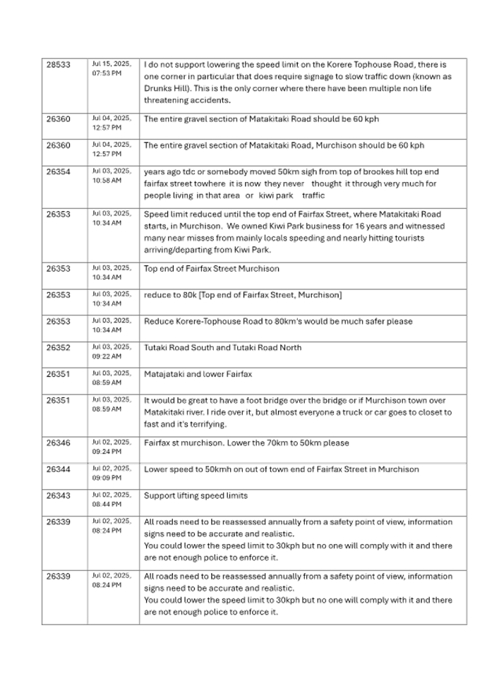
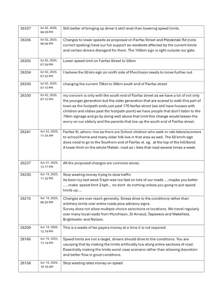
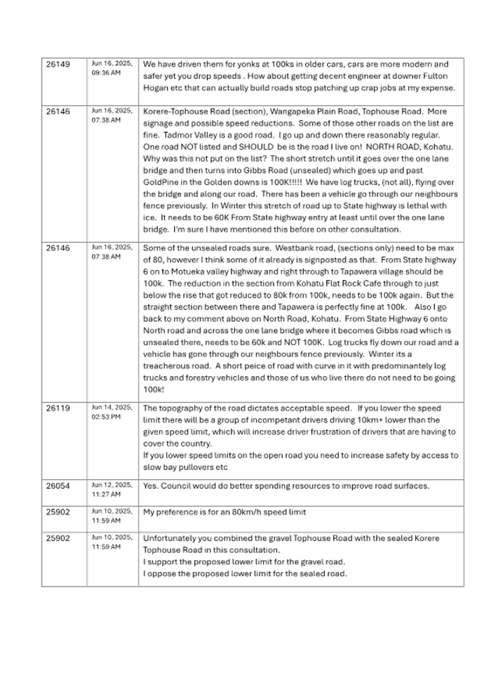

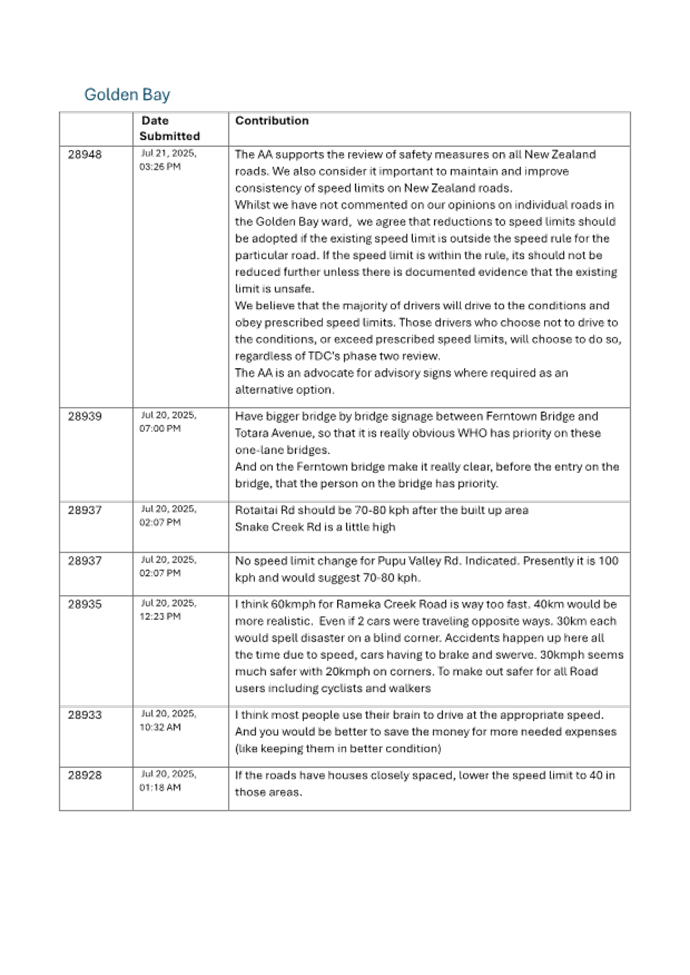
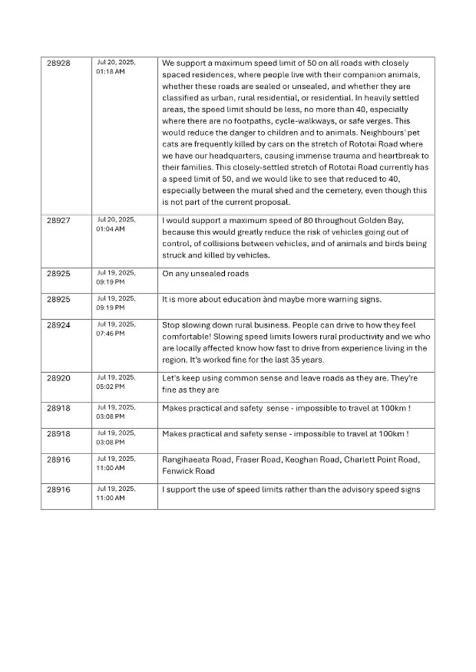
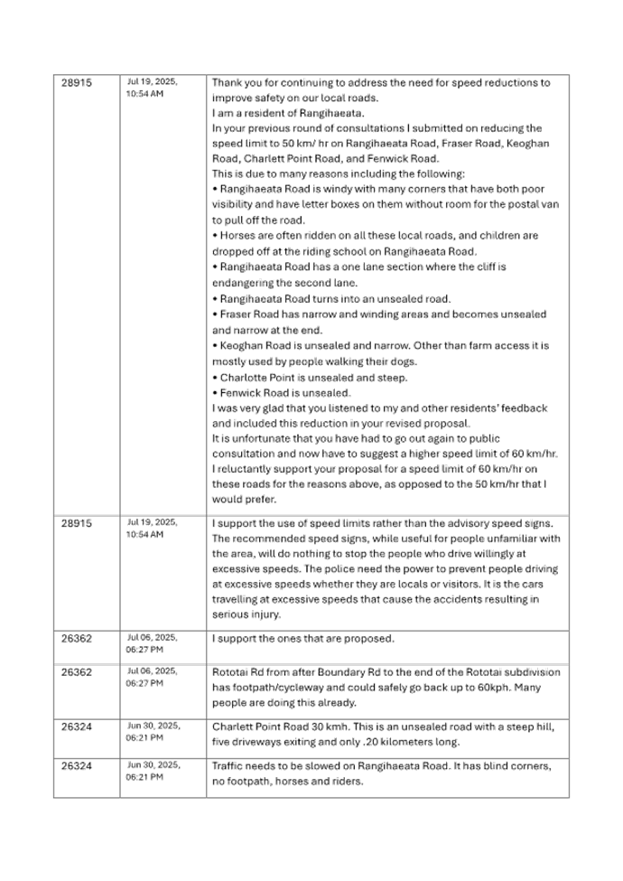
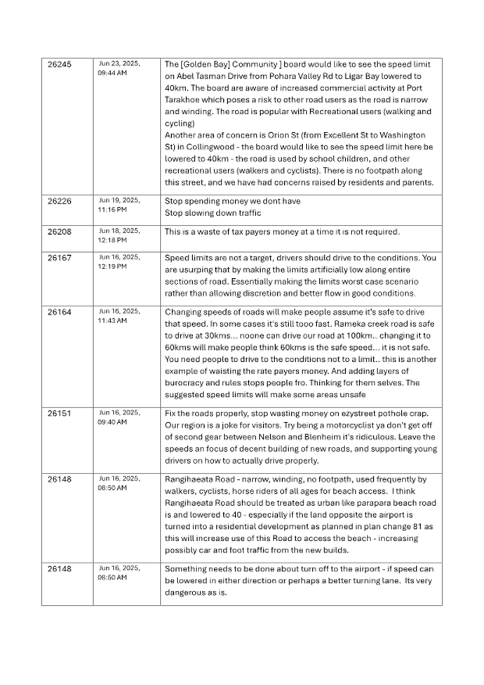
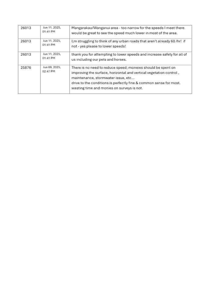
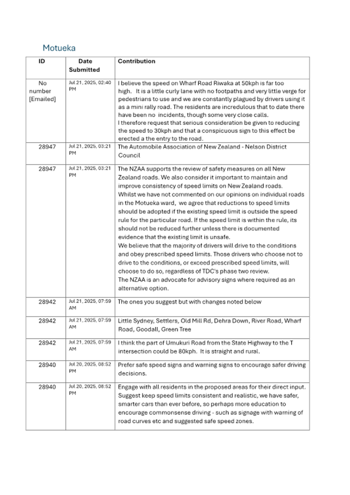
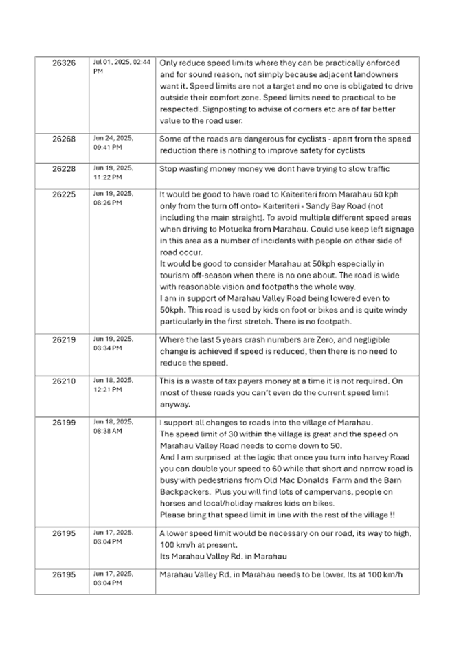
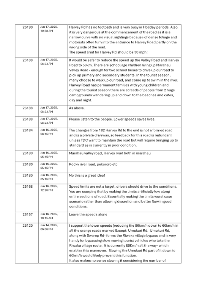
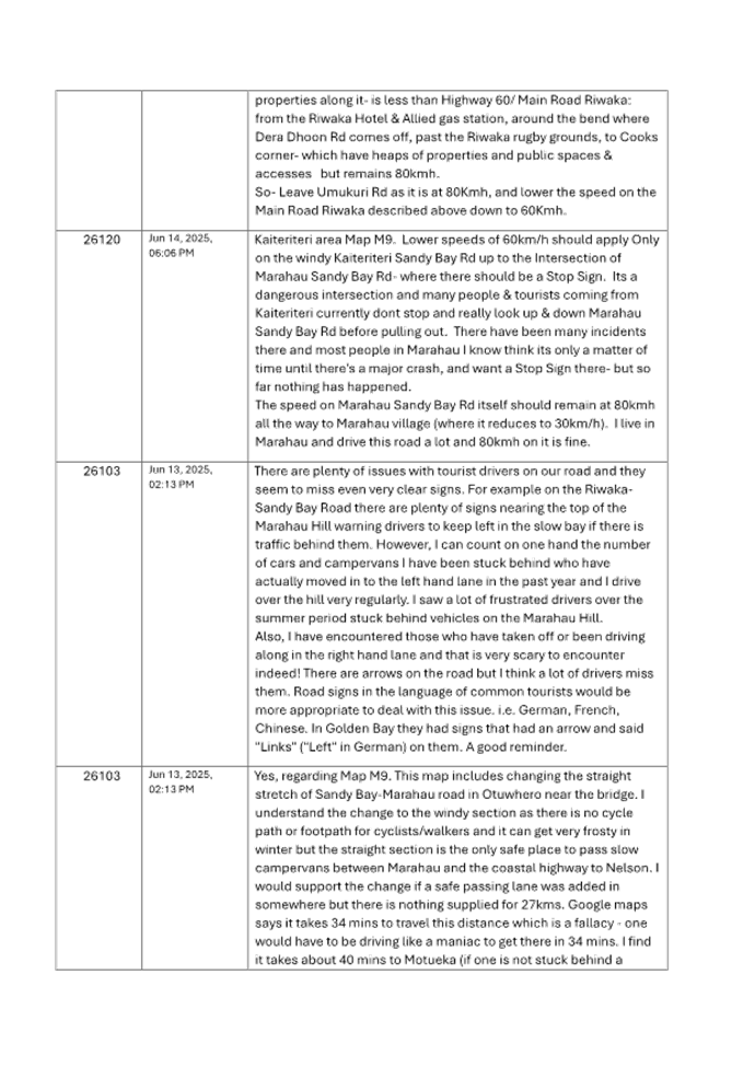
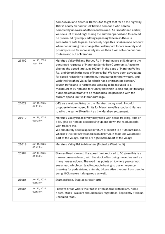


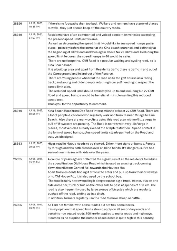
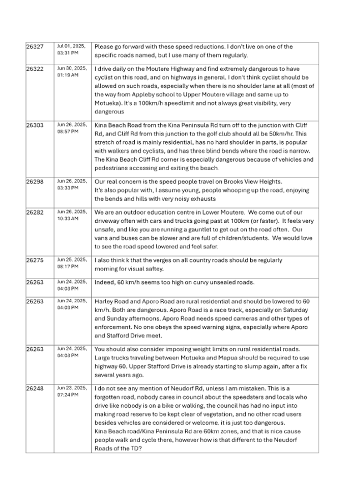
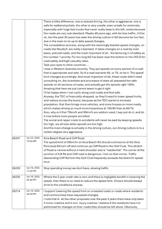
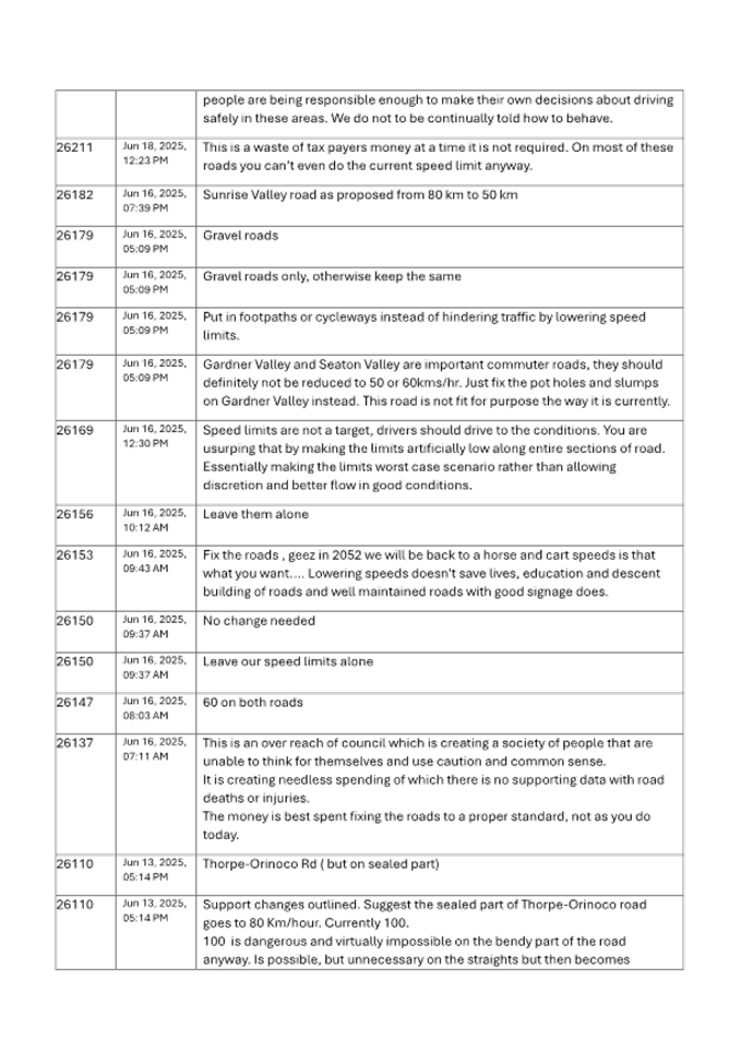
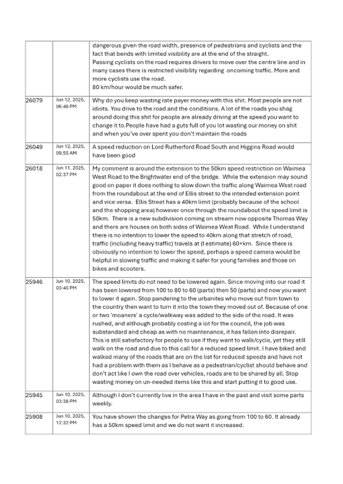
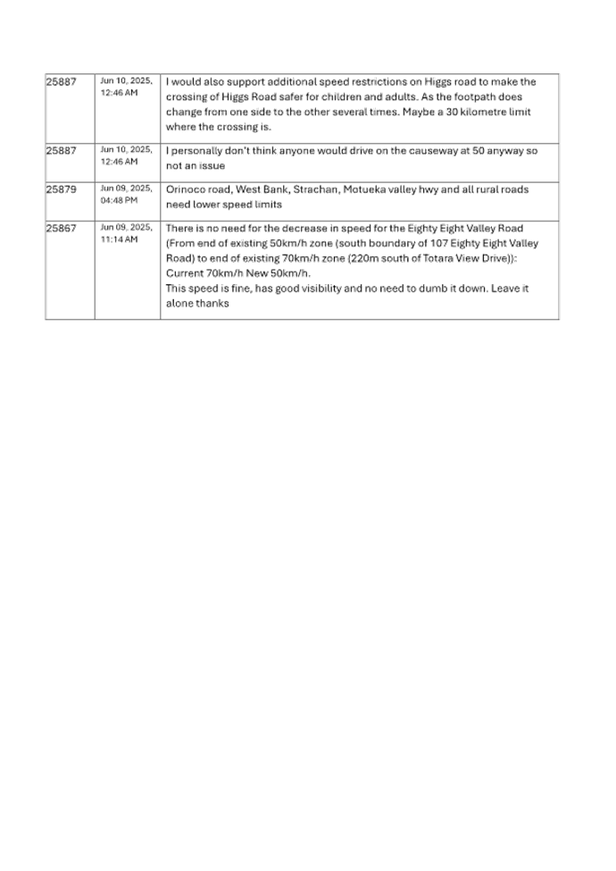
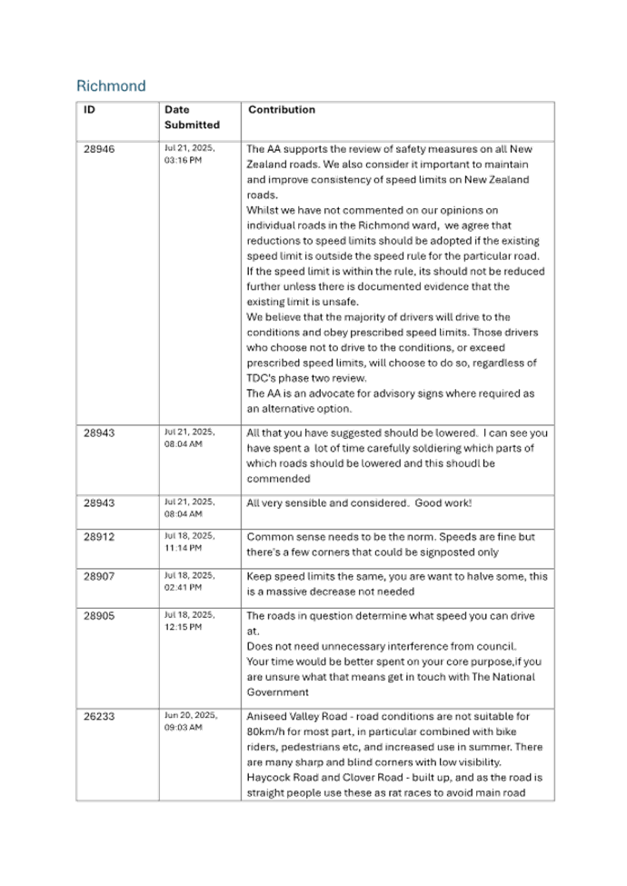
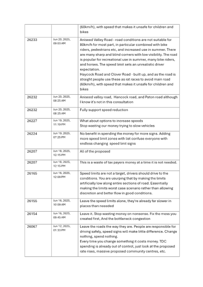
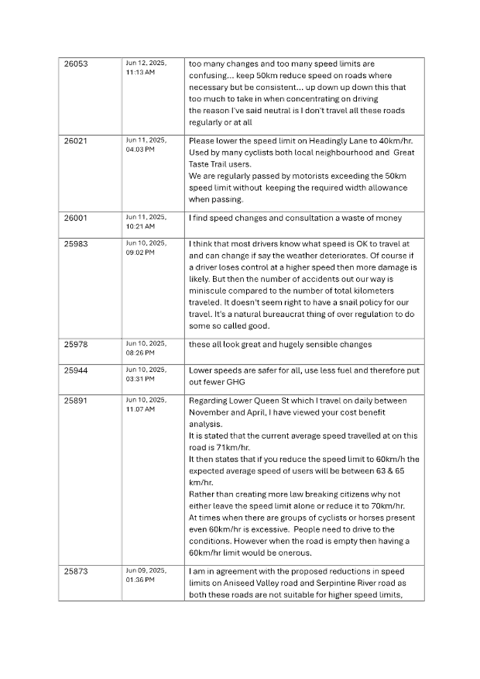
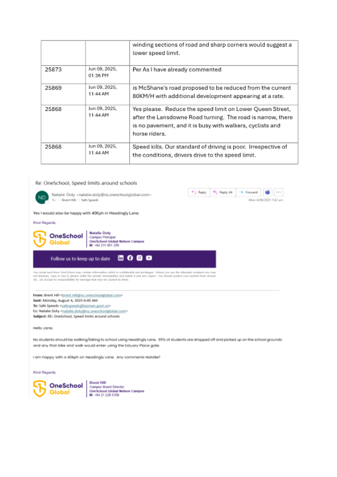
Tasman District Council Agenda – 14 August 2025
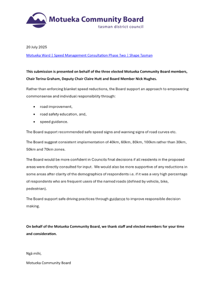
Tasman District
Council
Agenda – 14 August 2025

Tasman District Council Agenda – 14 August 2025
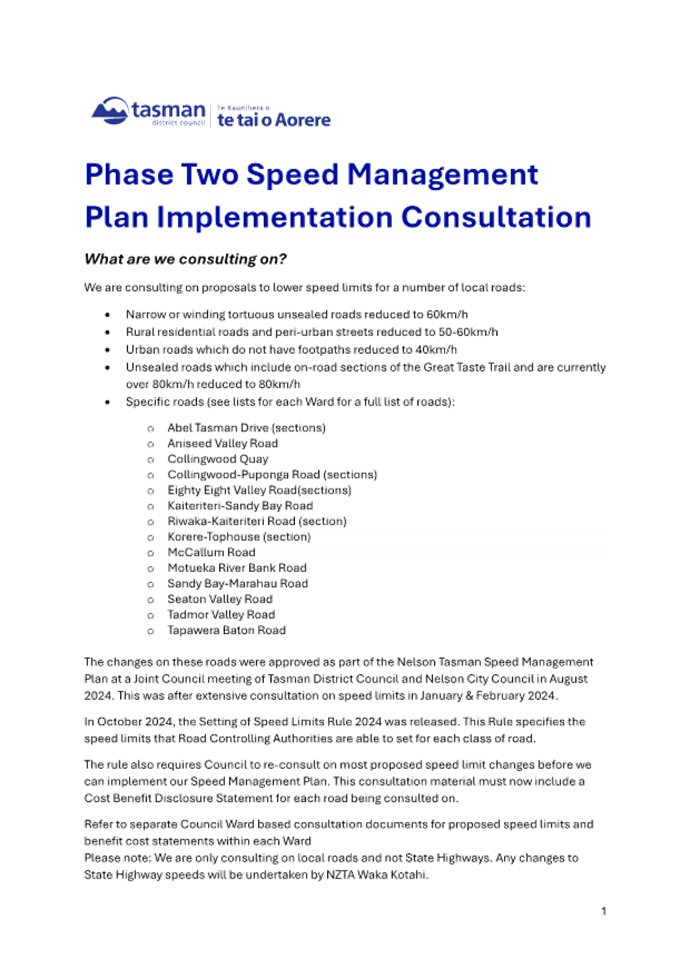
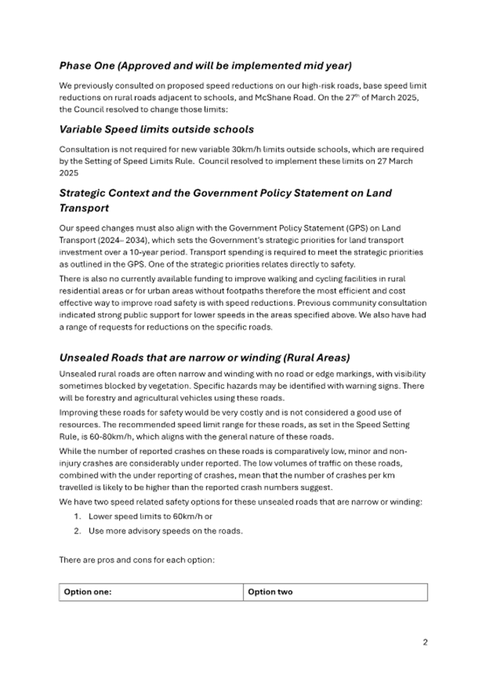
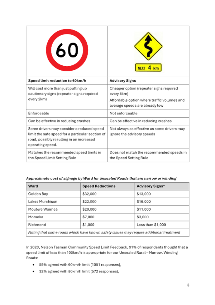
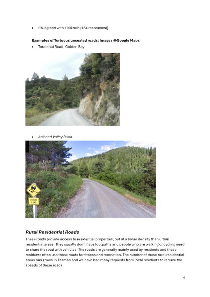
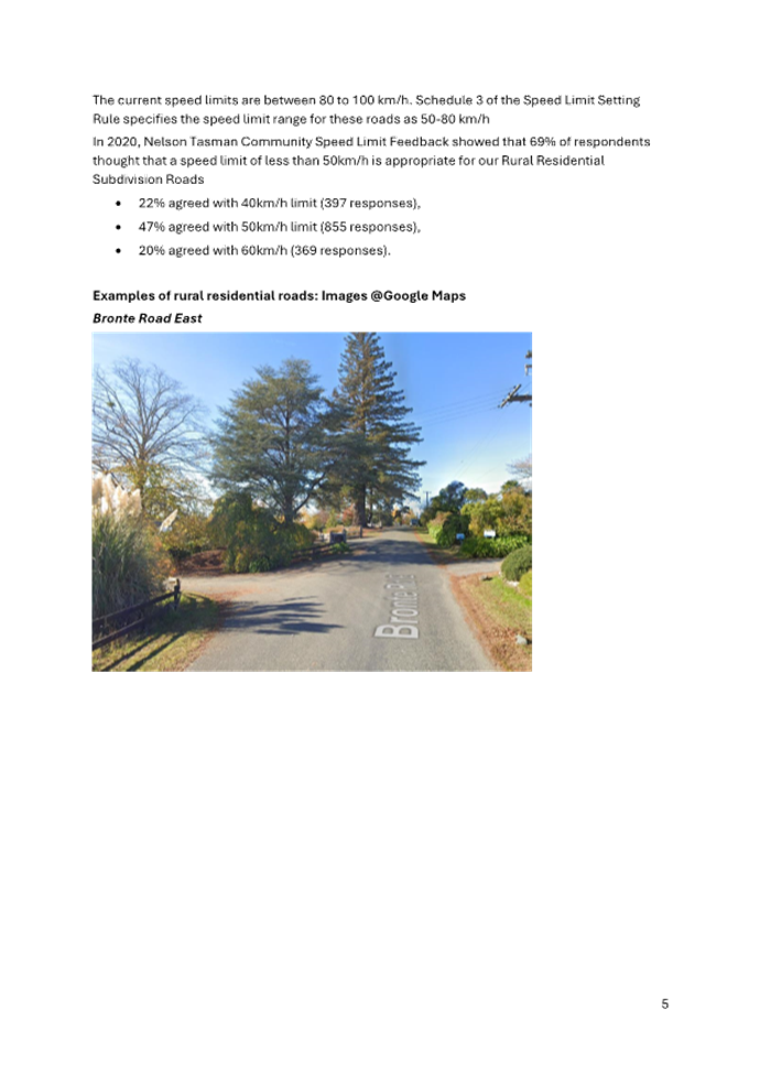
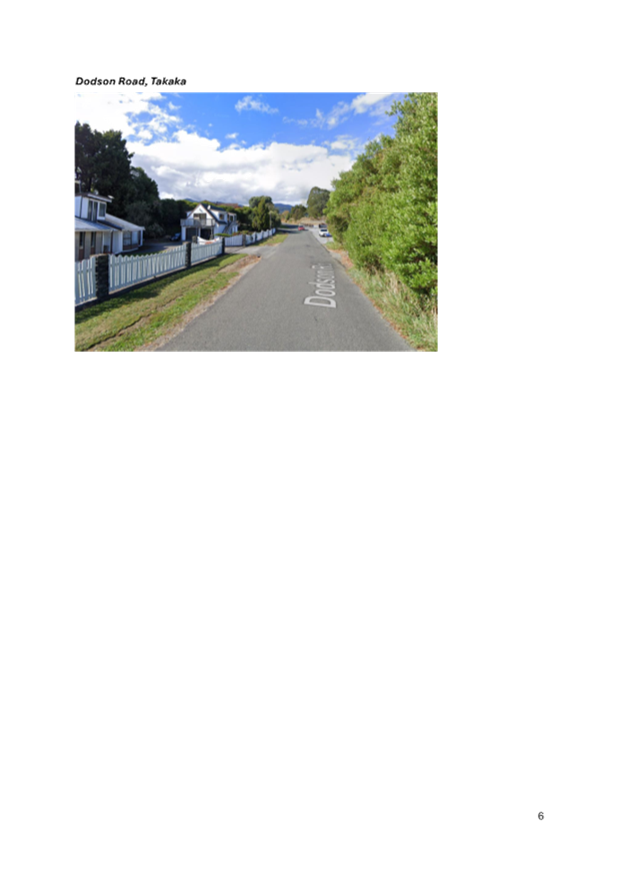
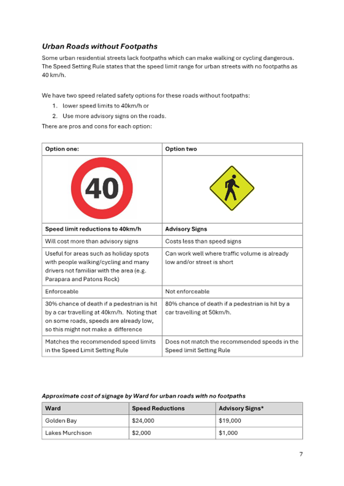
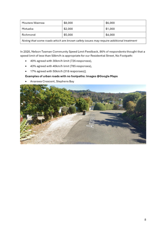
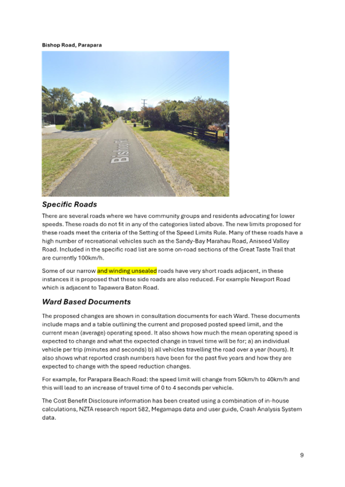

Tasman District Council Agenda – 14 August 2025

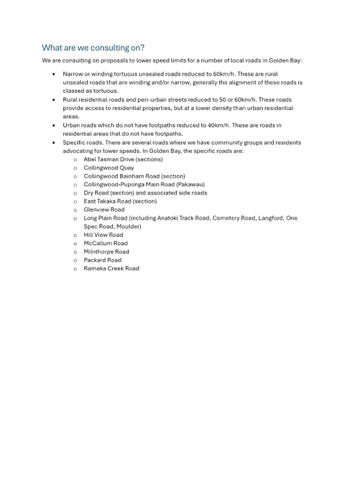
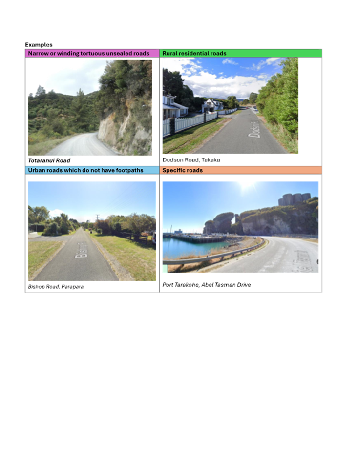
Tasman District Council Agenda – 14 August 2025
Tasman District Council Agenda – 14 August 2025
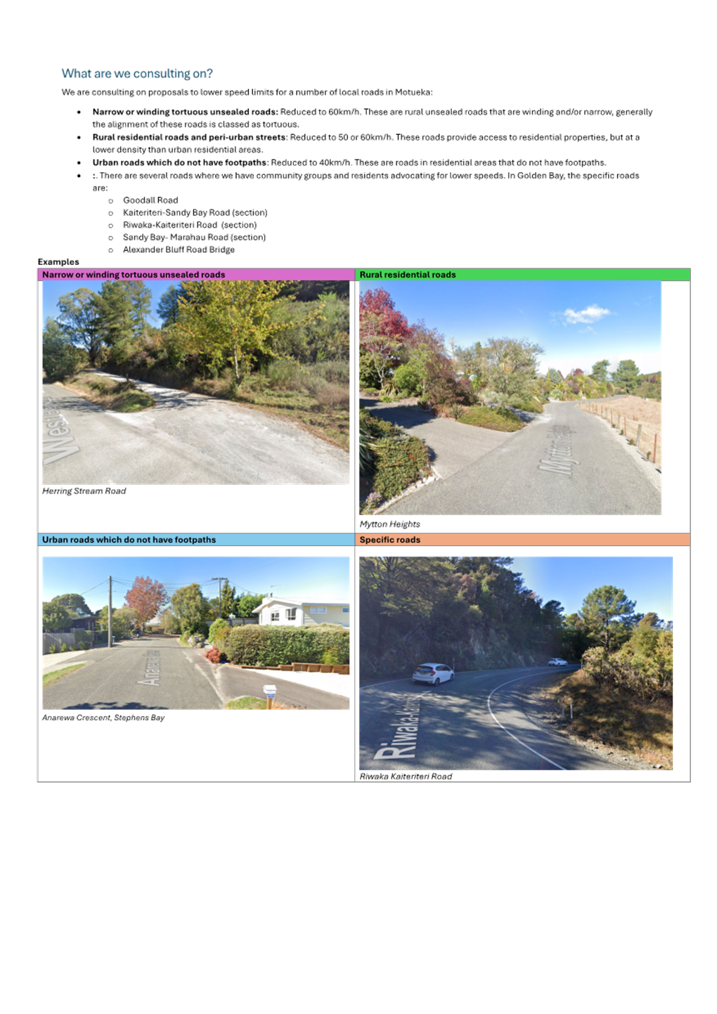
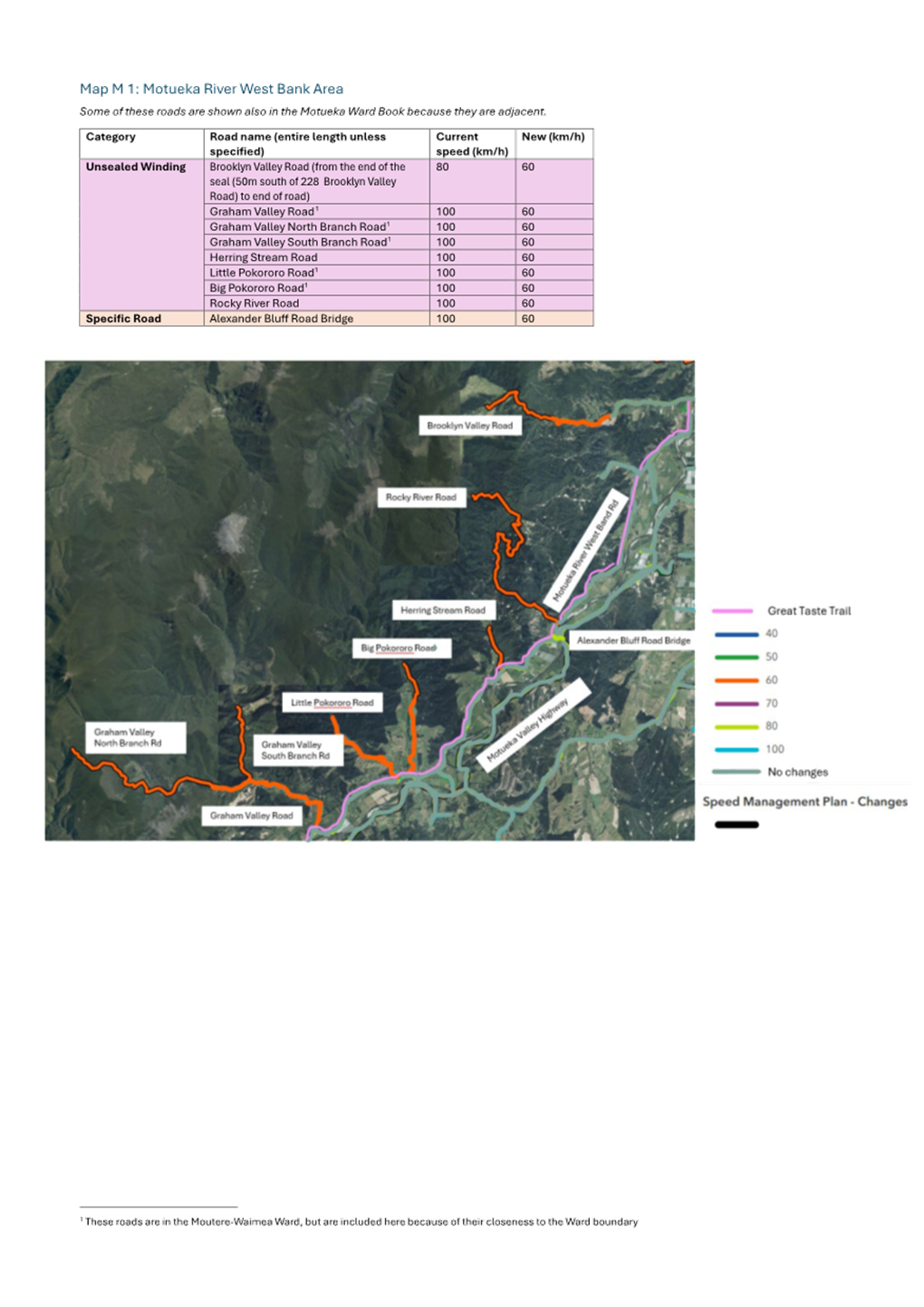
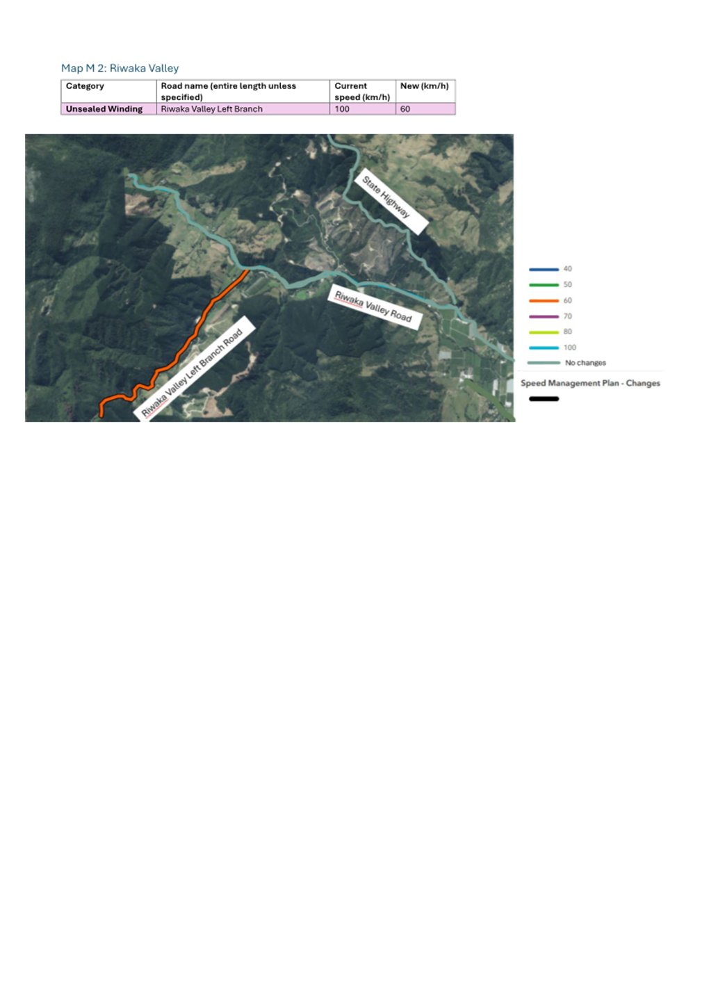
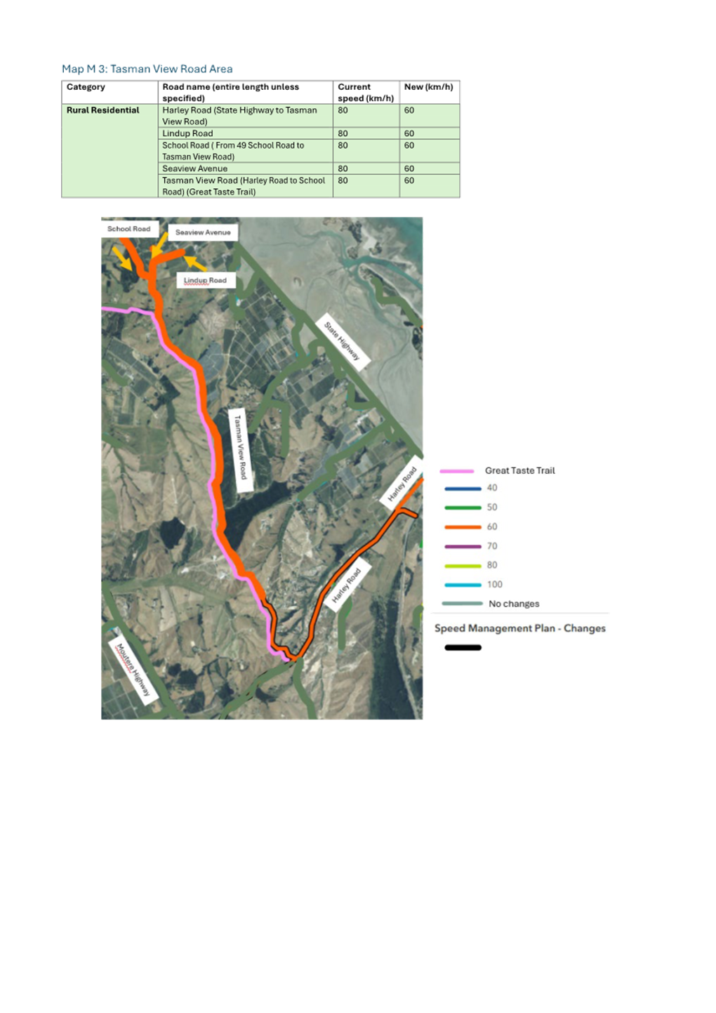
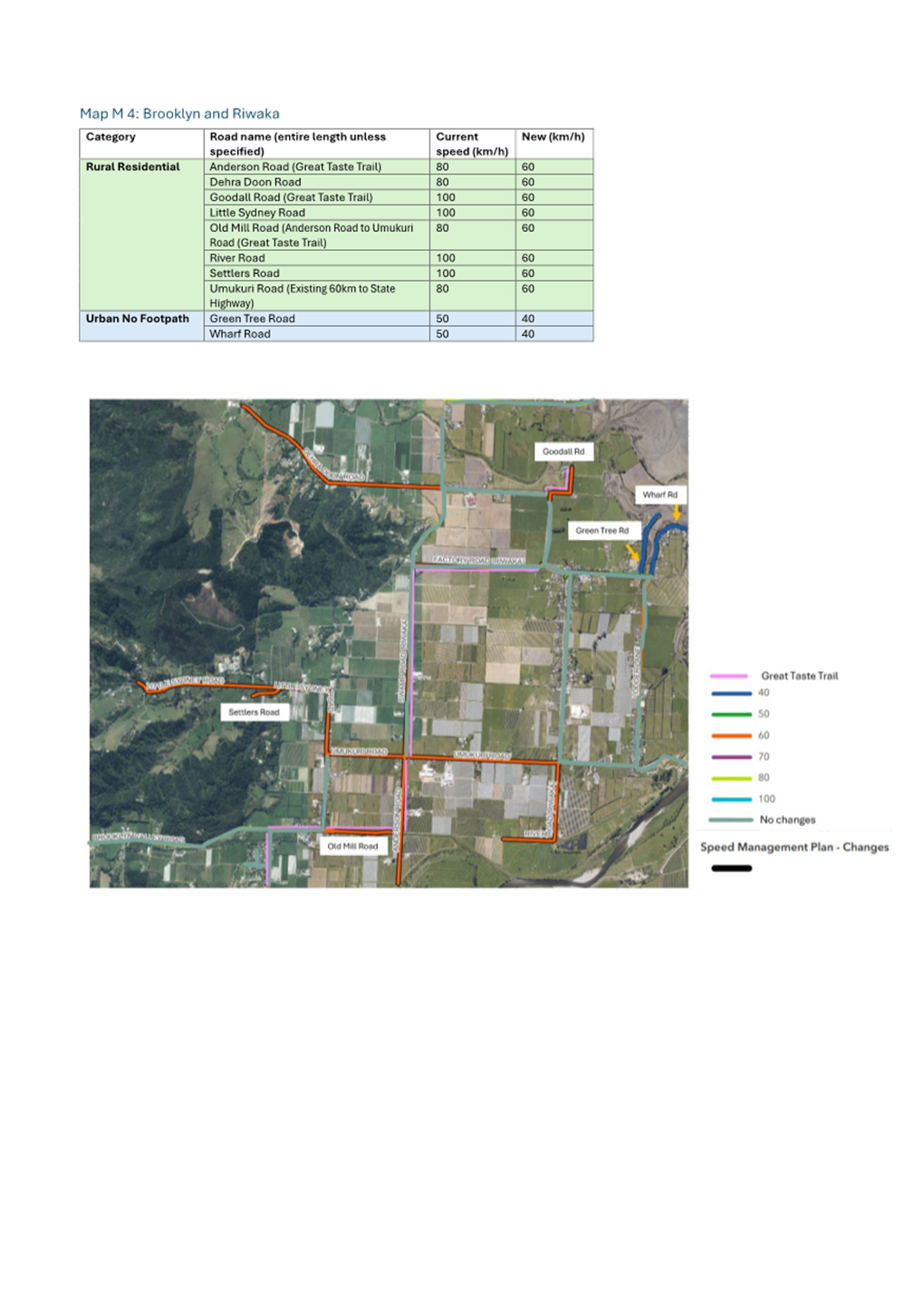
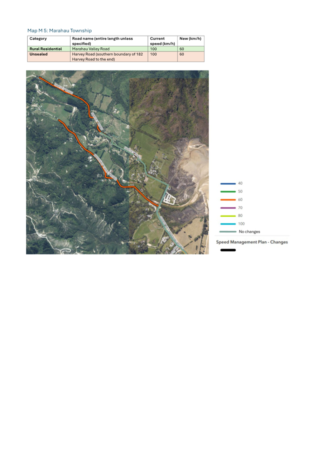
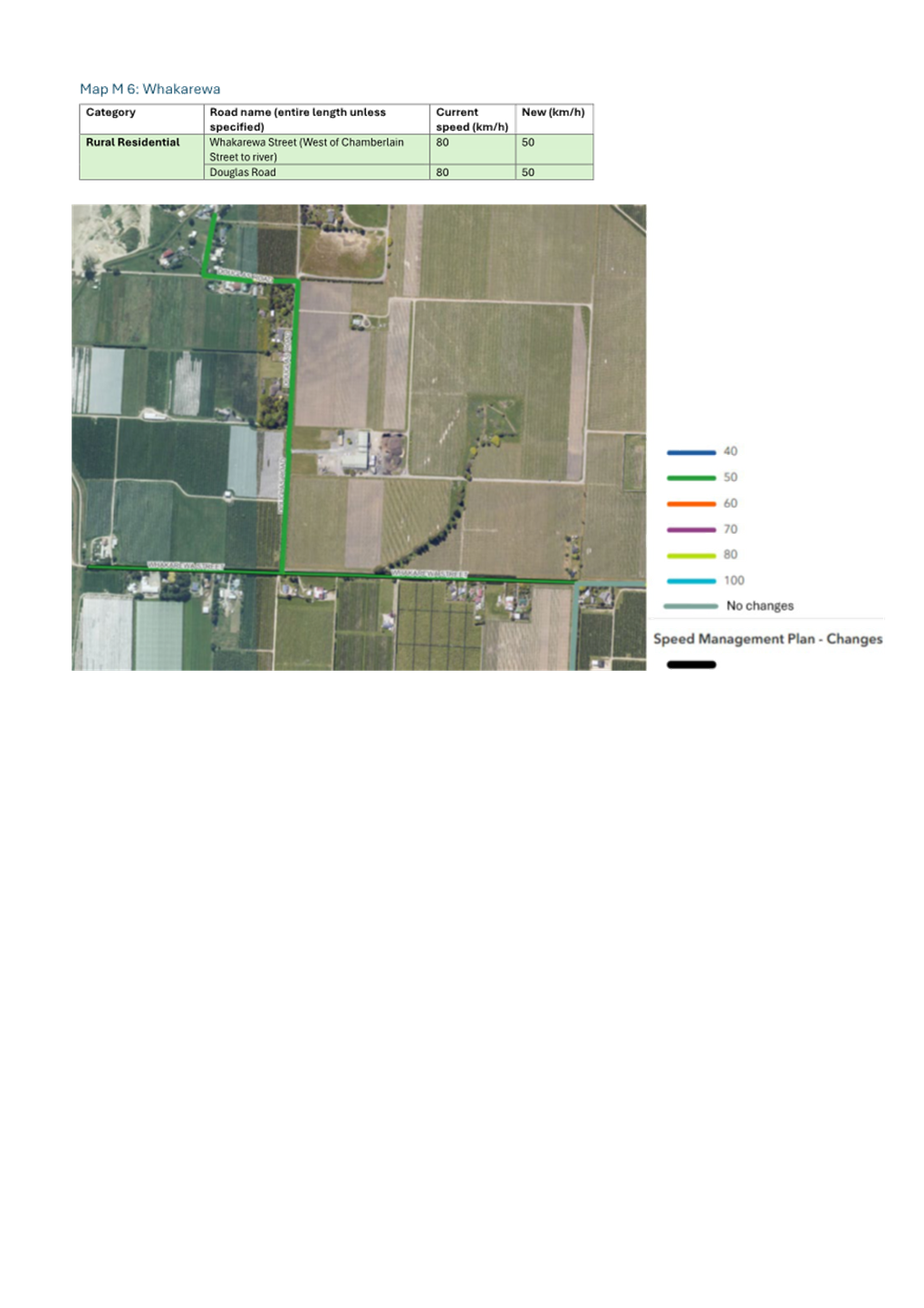
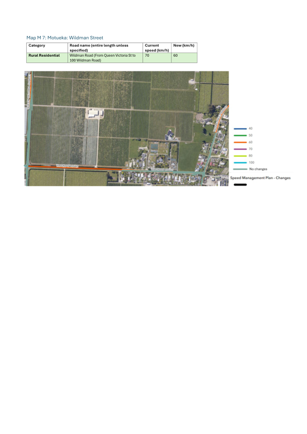
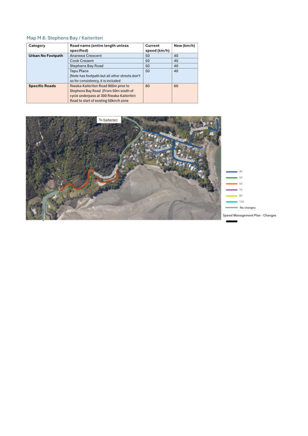
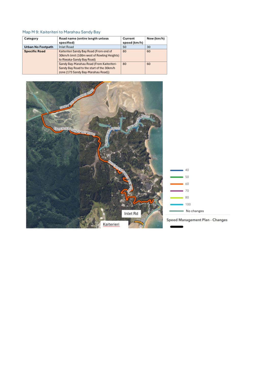
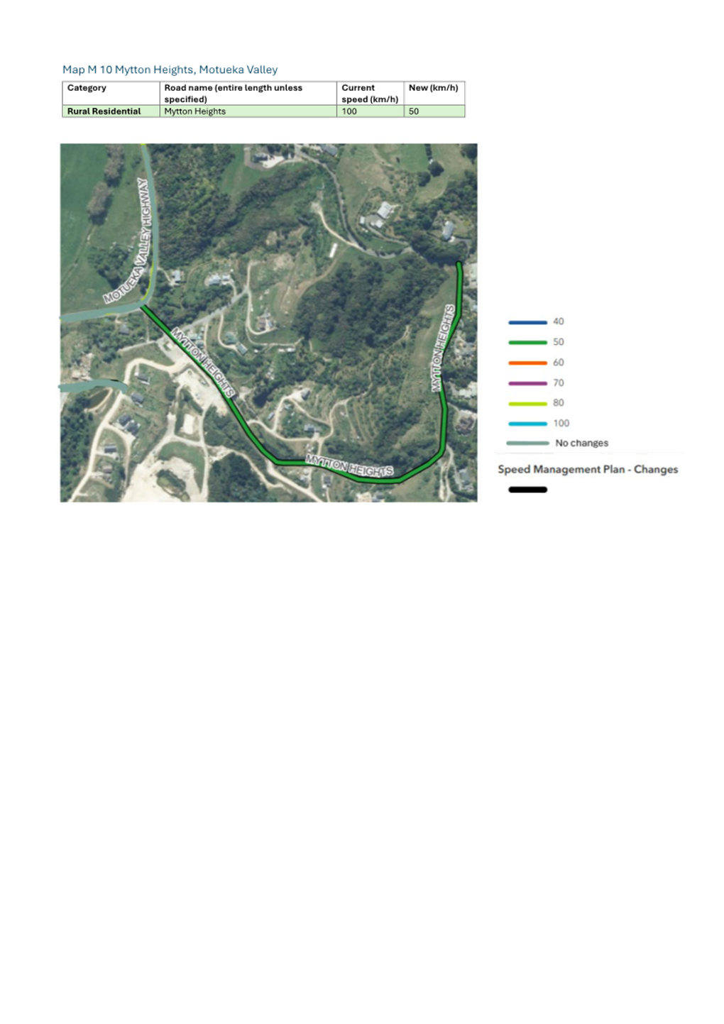
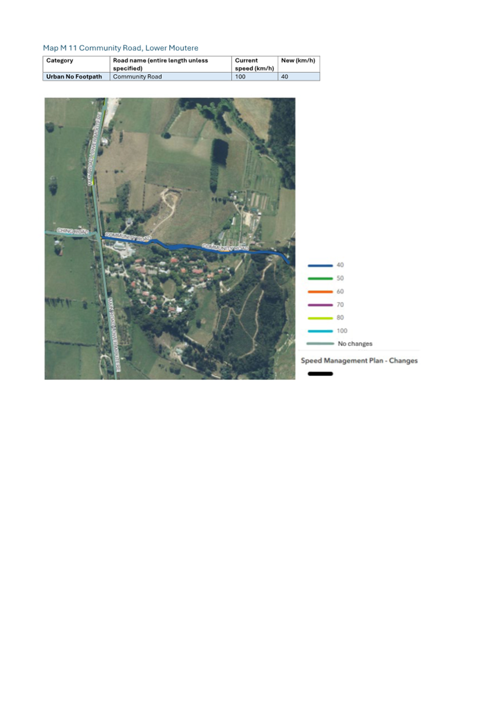
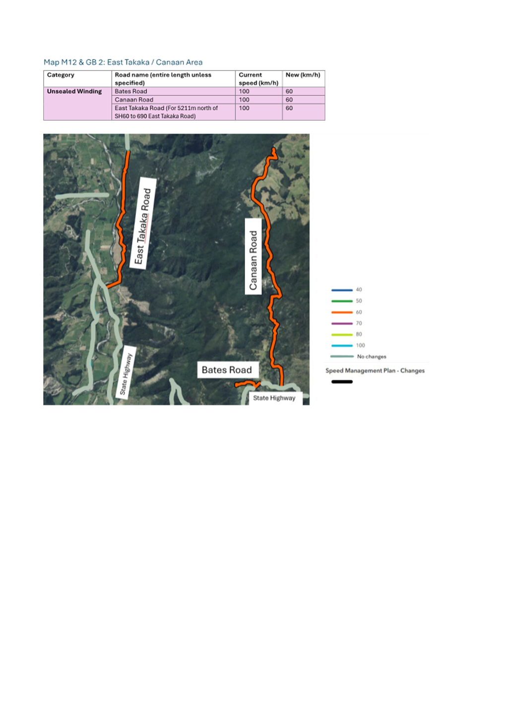
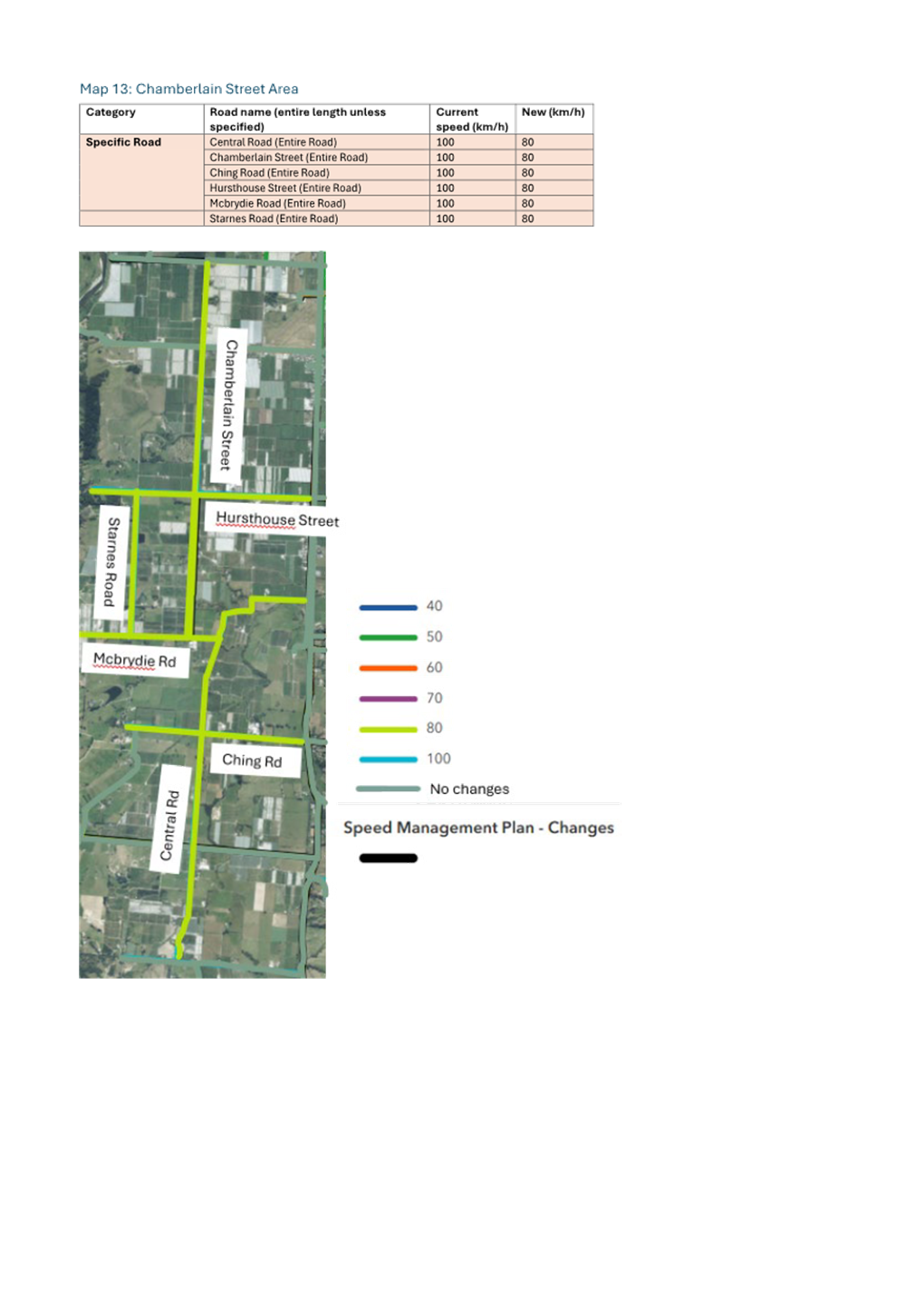
Tasman District Council Agenda – 14 August 2025
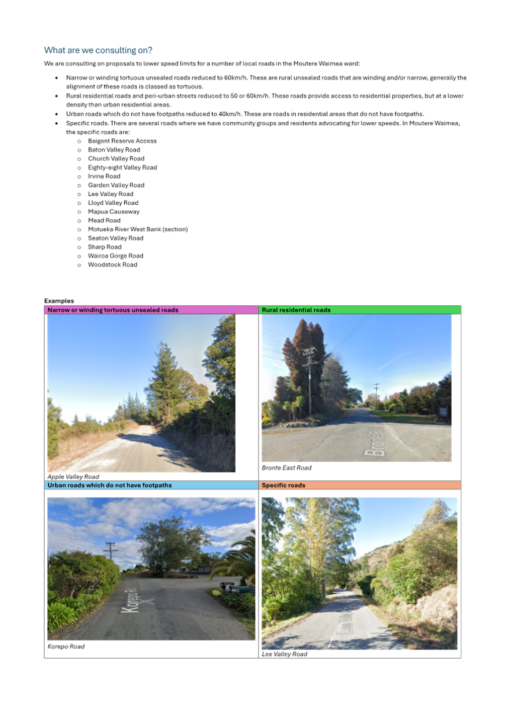
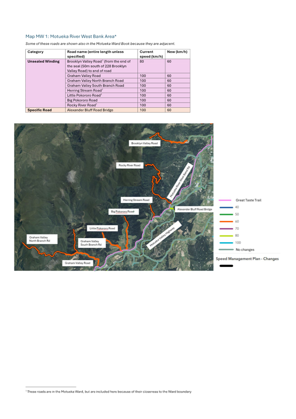
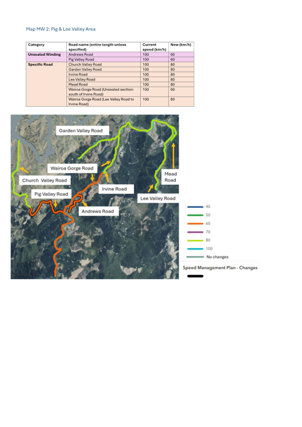
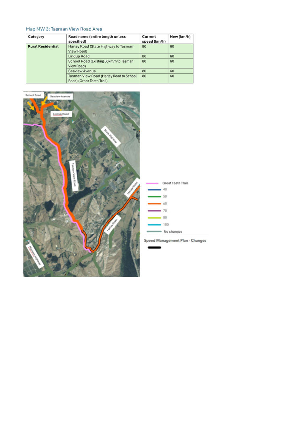
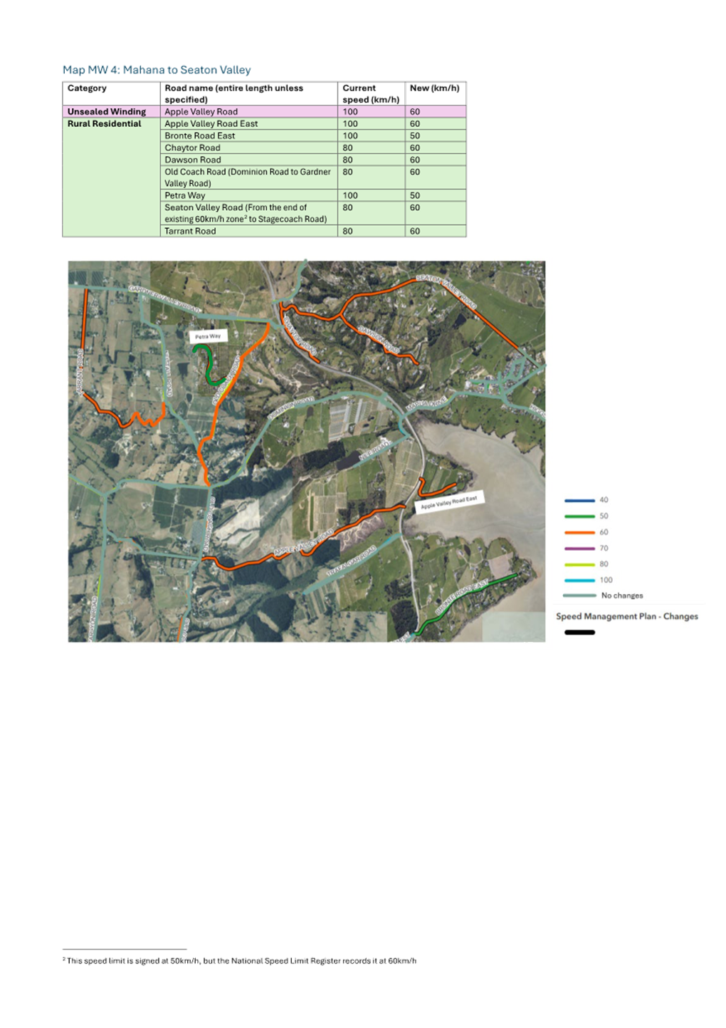
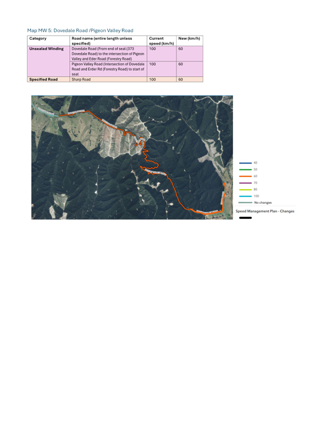
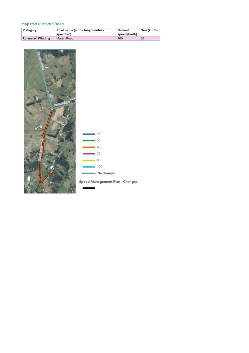
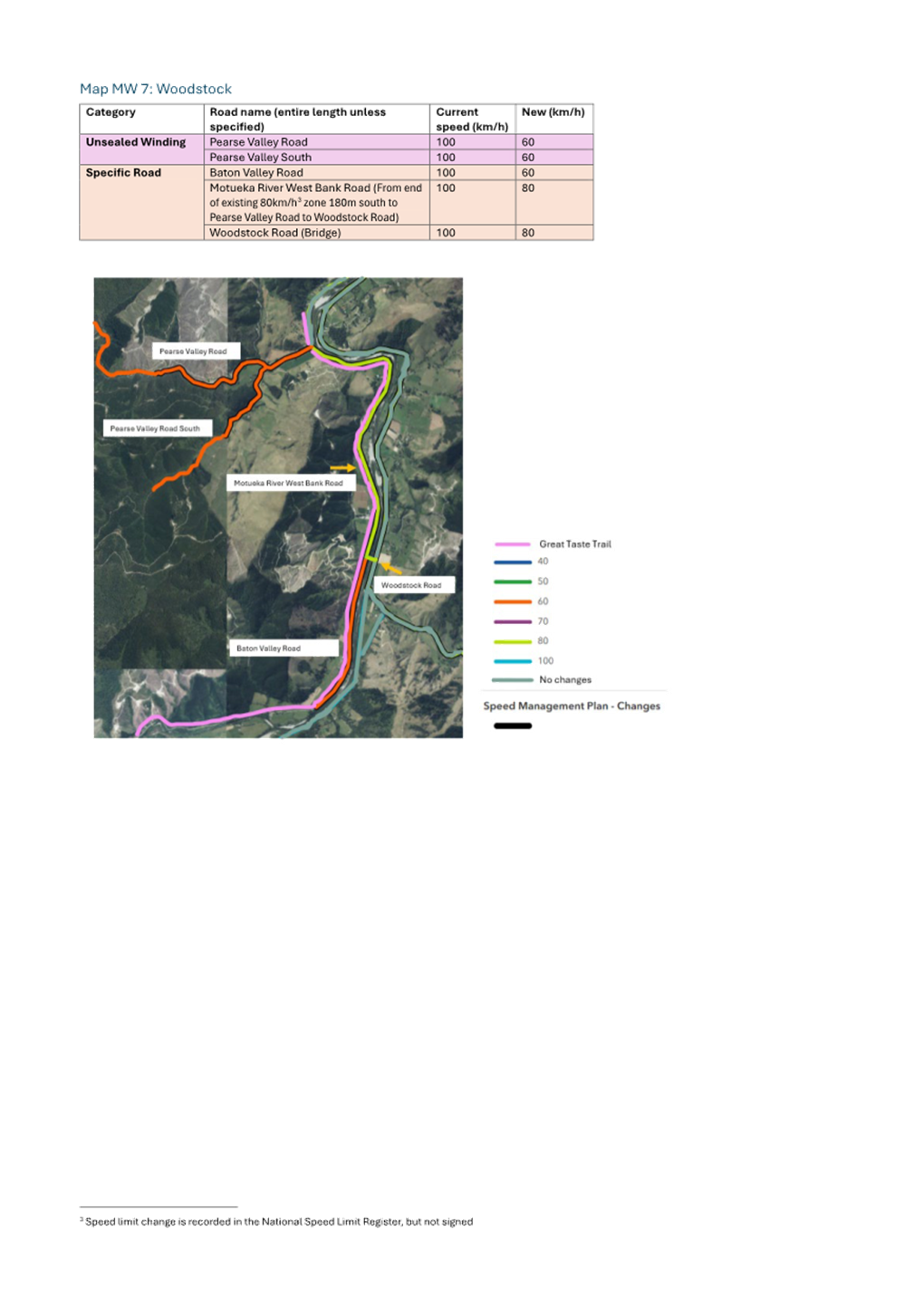
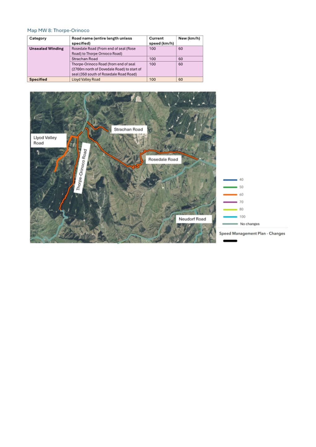
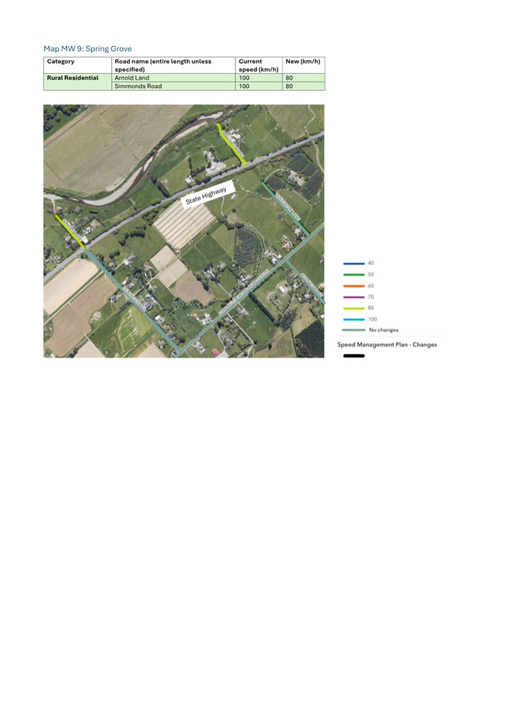
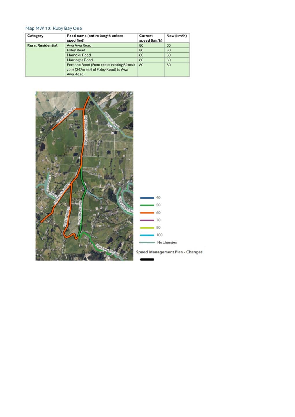
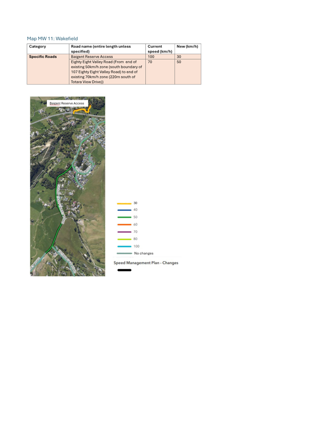
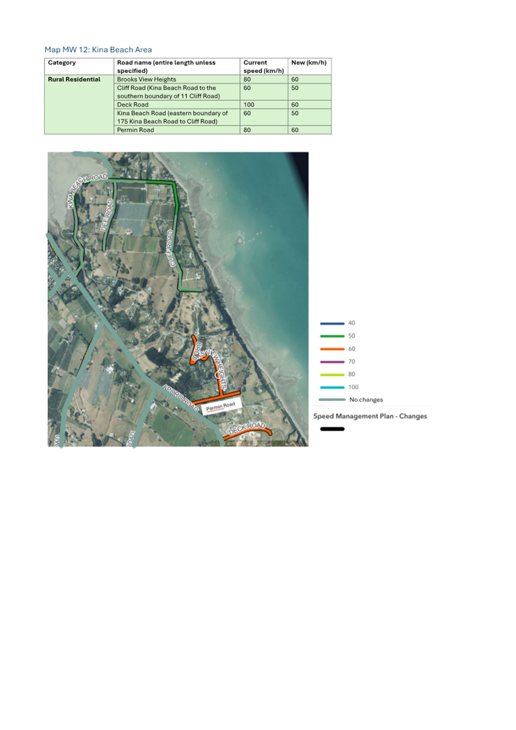
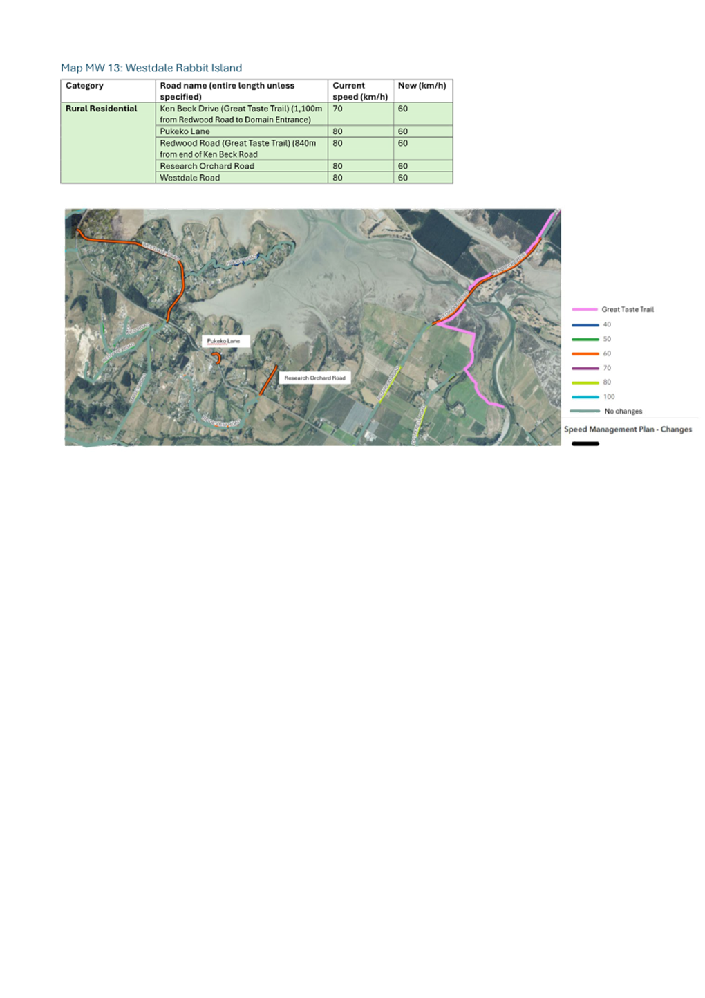
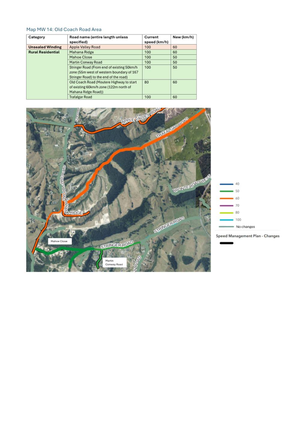
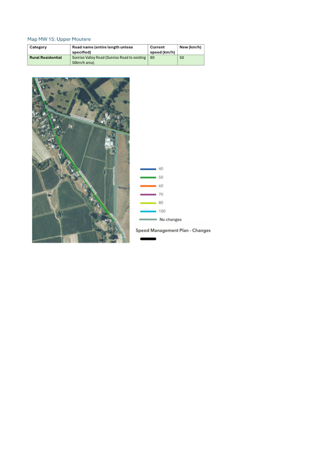
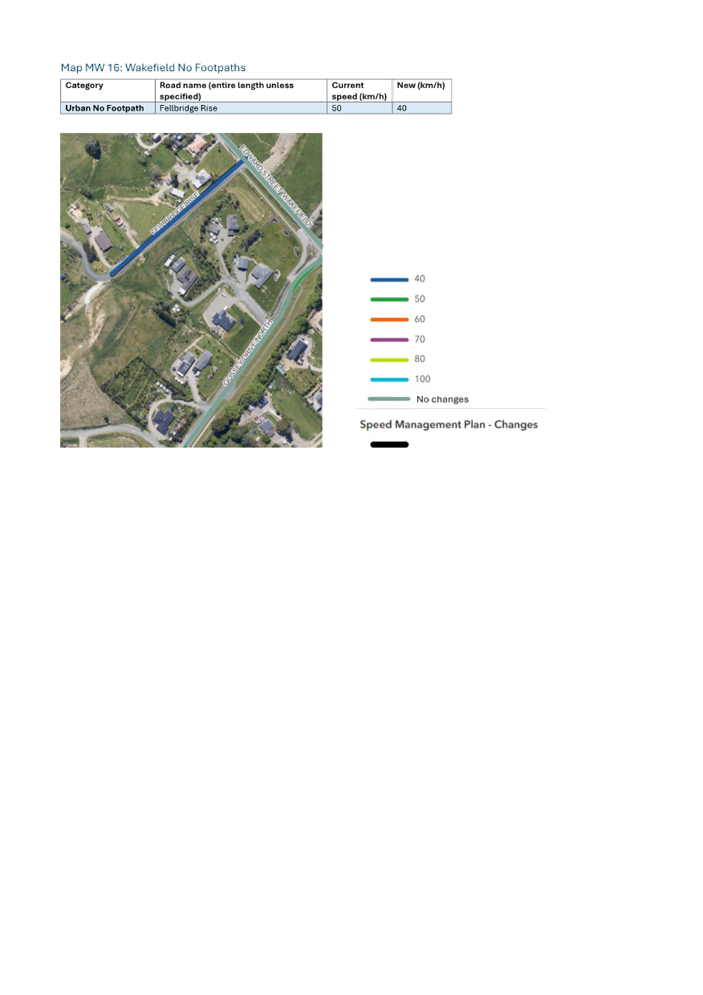
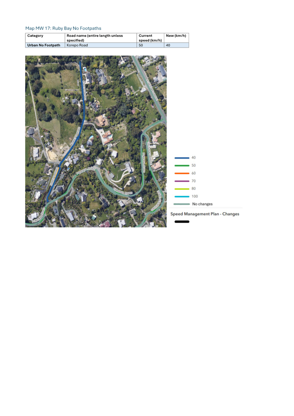
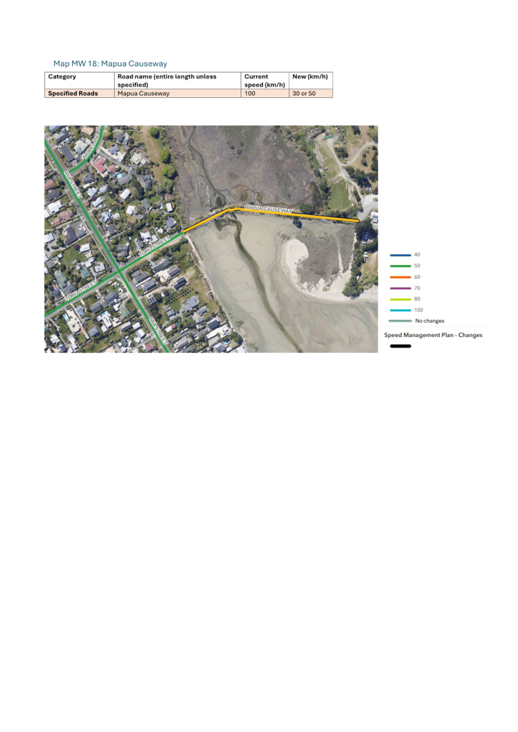
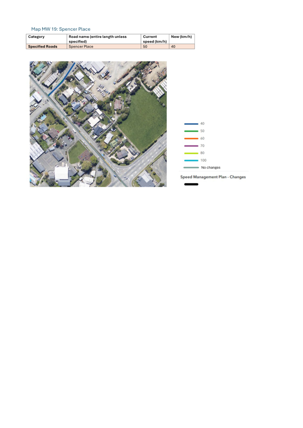
Tasman District Council Agenda – 14 August 2025
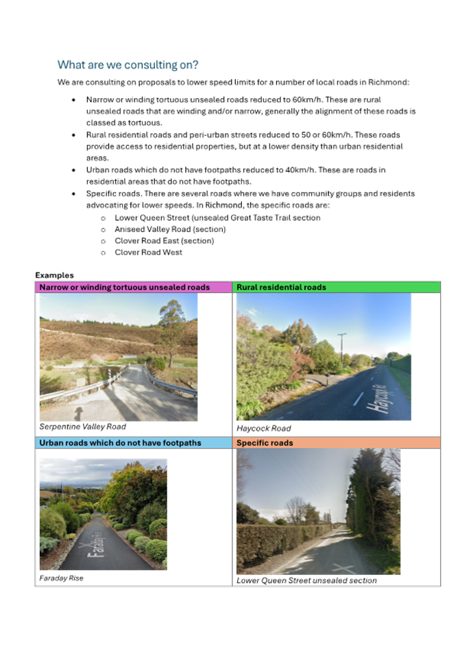
Tasman District Council Agenda – 14 August 2025
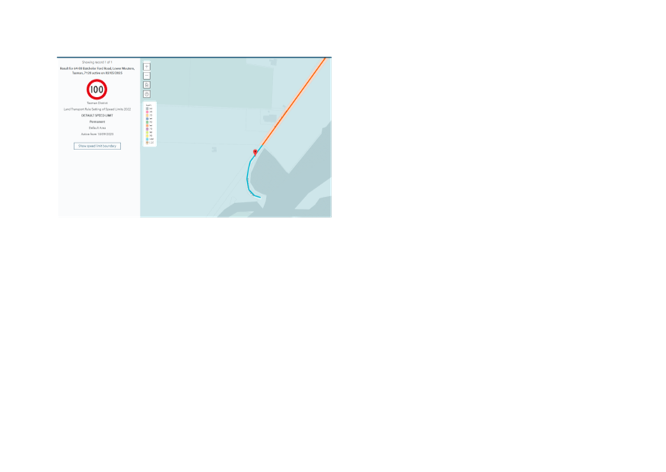
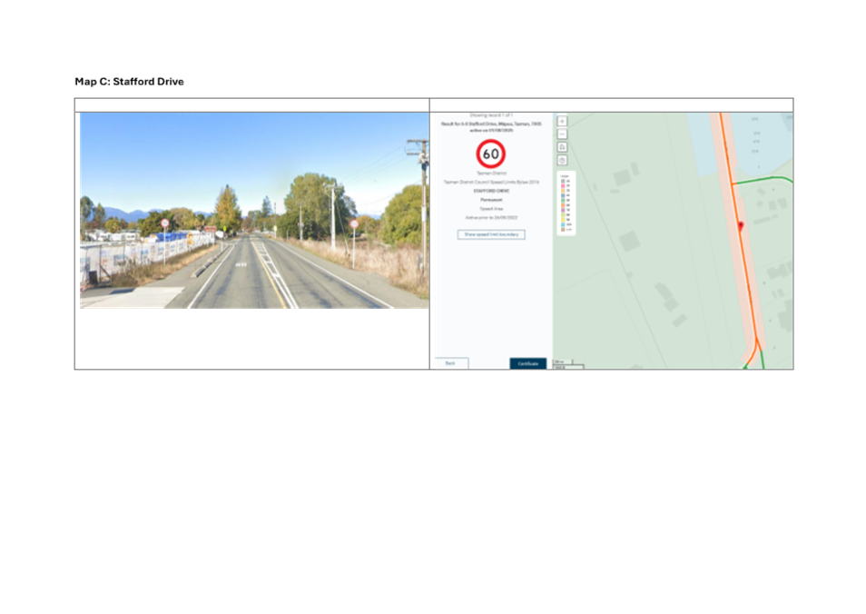
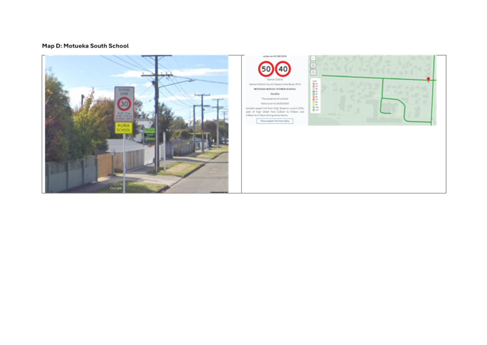
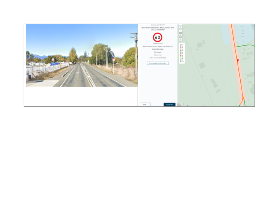
Tasman District Council Agenda – 14 August 2025
7.5 Māpua Masterplan
Decision Required
|
Report
To:
|
Tasman
District Council
|
|
Meeting
Date:
|
14
August 2025
|
|
Report
Author:
|
Anna
McKenzie, Principal Planner – Environmental Policy; Ian McComb, Senior
Infrastructure Planning Advisor - Stormwater, Rivers and Coasts
|
|
Report
Authorisers:
|
Dwayne
Fletcher, Strategic Policy Manager; Barry Johnson, Environmental Policy
Manager
|
|
Report
Number:
|
RCN25-08-5
|
1. Purpose
of the Report / Te Take mō te Pūrongo
1.1 The
purpose of this report is to:
1.1.1 provide the recommendations from the 5 June
2025 Māpua Masterplan deliberations meeting to the Council; and
1.1.2 seek the adoption of the Final Māpua
Masterplan including the Māpua Catchment Management Plan.
2. Summary
/ Te Tuhinga Whakarāpoto
2.1 Following
a nearly two-year process of engagement with the community, the Council
approved a draft Māpua Masterplan and Māpua Catchment Management Plan
for formal consultation. The Council received 128 submissions on the drafts and
at a public hearing on 26 March 2025, 24 submitters attended and presented
their submission.
2.2 On
5 June 2025, the Strategy and Policy Committee deliberated on changes to the
Masterplan (RSH25-06-1). The Committee resolved
to recommend that the Council adopt the masterplan, with several changes. The
meeting minutes can be found at Minutes
of Submissions Hearing - Thursday, 5 June 2025.
2.3 In
addition to the changes recommended during the deliberations, two minor changes
have been made since this meeting under delegated authority. These were:
2.3.1 A minor amendment has been made to the Higgs Road
greenfield land which is identified on the draft maps as ‘Future Open
Space’ (Part 120 Higgs Road). The Future Open Space Mapping has been
amended to ‘Future Stormwater Detention and Wetland’ to better
align with the expected future use of this area as shown in Figure 1.
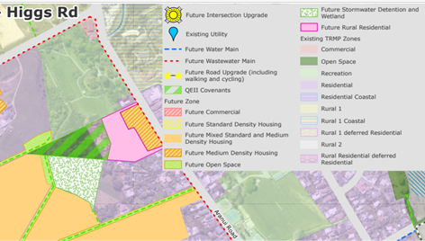
Figure 1: Extract of part Higgs Road Greenfield Land from
Final Masterplan document. Note – Future Stormwater Detention and Wetland
Area.
2.3.2 The second minor amendment includes the area of 49
Stafford Drive adjoining Stafford Drive which was excluded from the draft
Masterplan maps and is currently zoned Rural 1 deferred Rural Residential. It
is referenced in the final Masterplan as ‘Future Open Space’, this
is to recognise the cultural and ecological values associated with this parcel
of land. Figure 2 below illustrates the area.
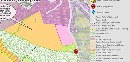
Figure 1: Extract of part 49 Stafford Drive from Final
Masterplan document. Note: Future Open Space Area
2.4 Having
incorporated these changes and the changes agreed through deliberations, staff
now seek approval of the final Māpua Masterplan.
3. Recommendation/s
/ Ngā Tūtohunga
That the Tasman District Council;
1. receives
the Tasman District Council Māpua Masterplan Report, RSC25-08-5; and
2. adopts the Māpua Masterplan, including the Māpua
Catchment Management Plan (Attachment 1 to the agenda report).
Tasman District
Council
Agenda – 14 August 2025
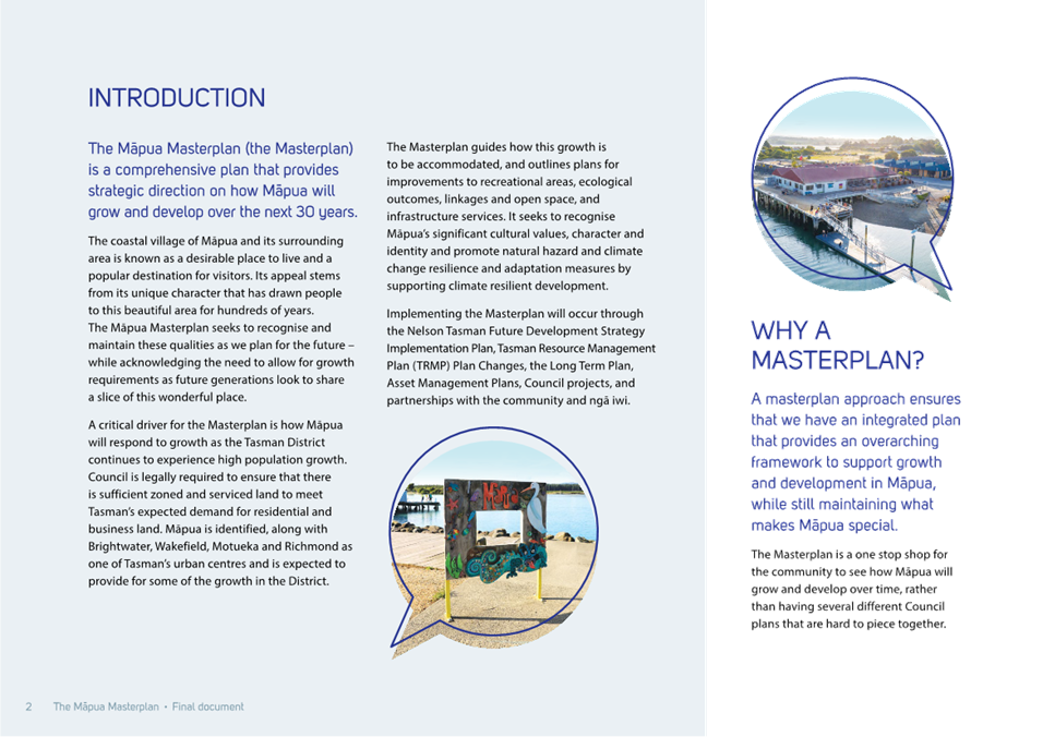
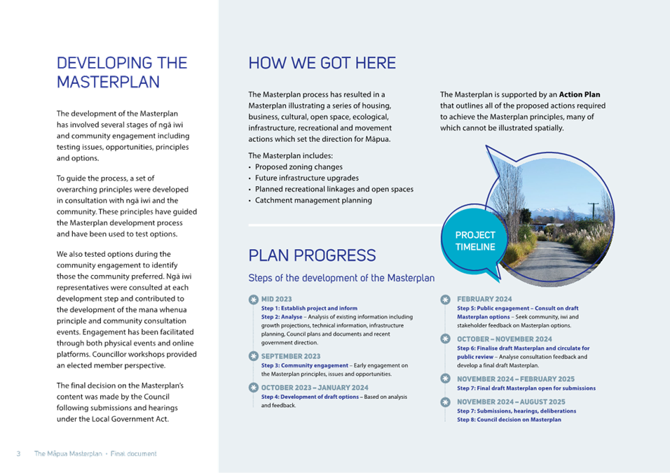
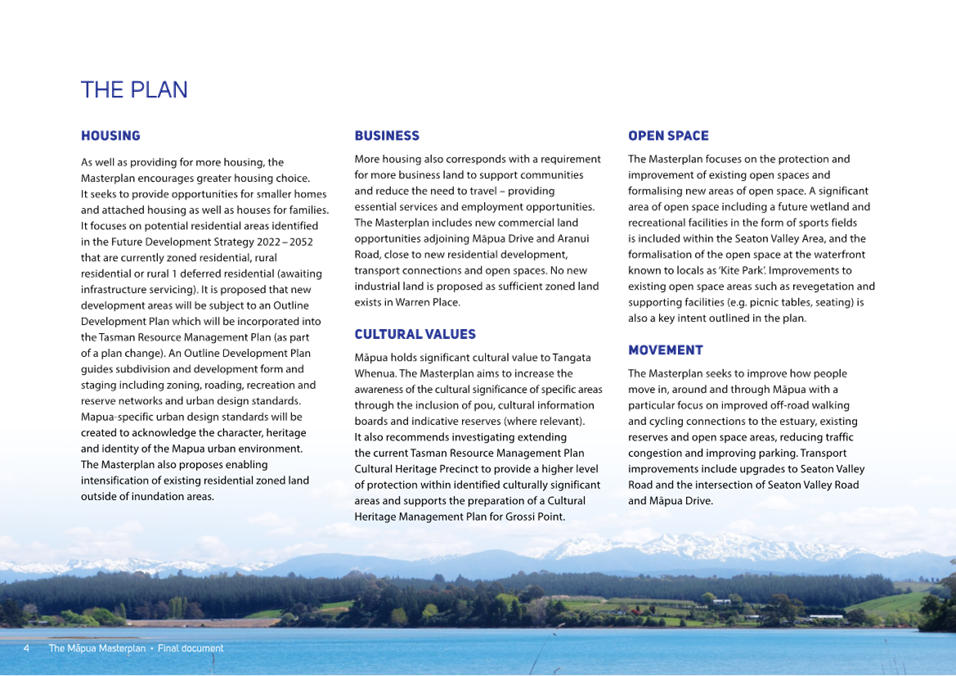
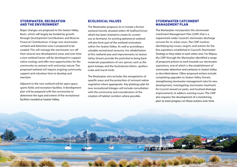
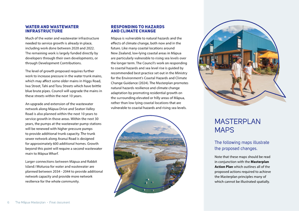
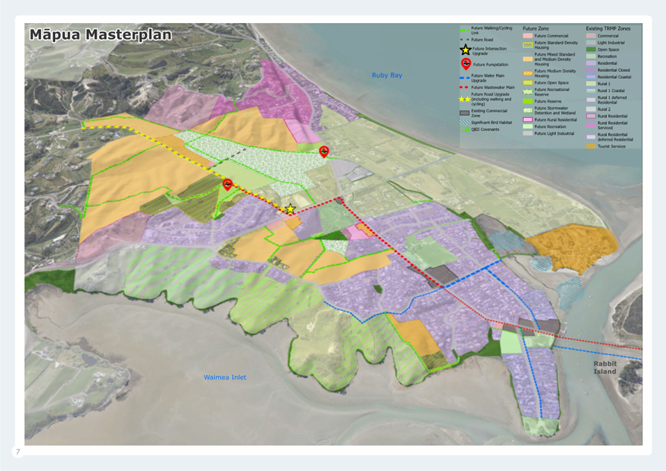
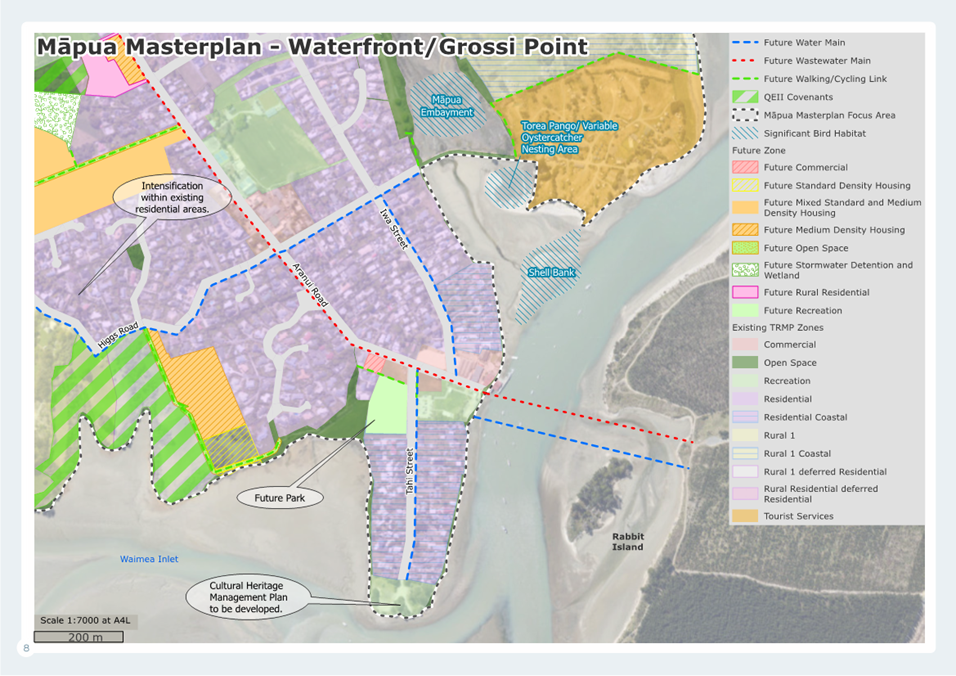
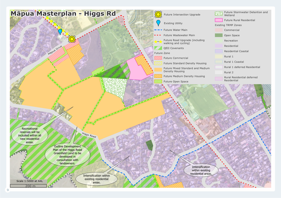
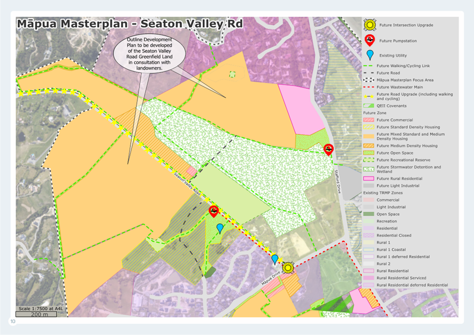
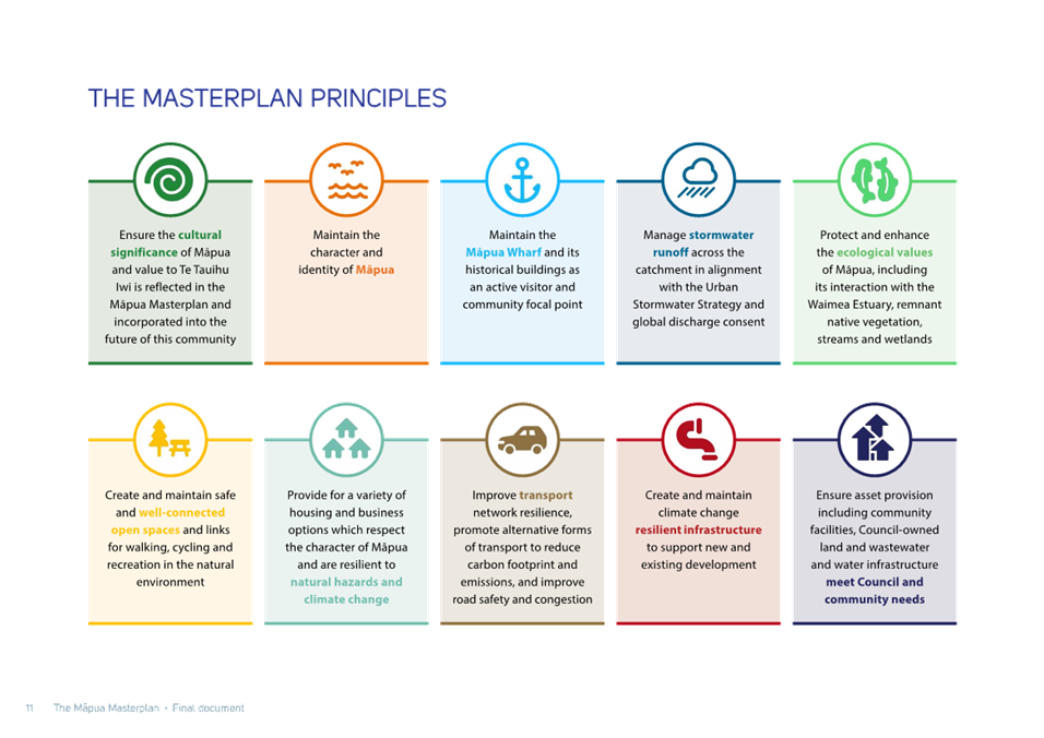
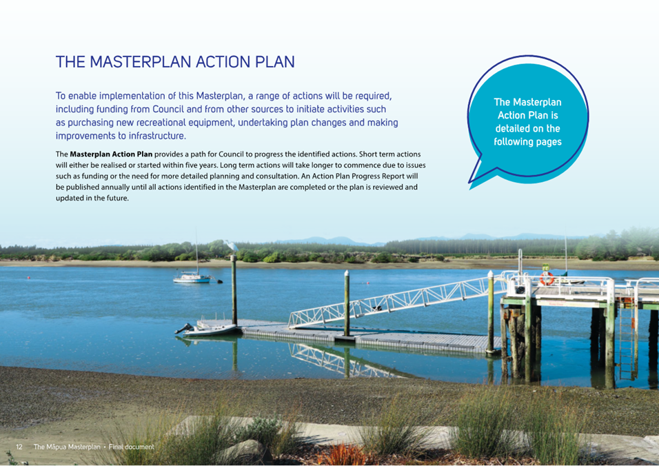
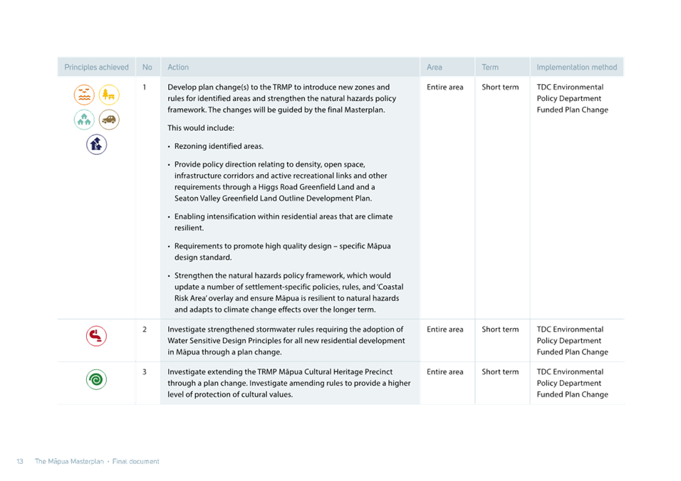
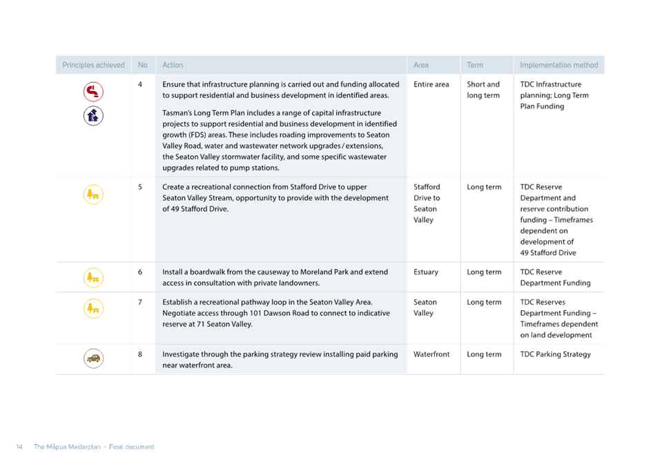
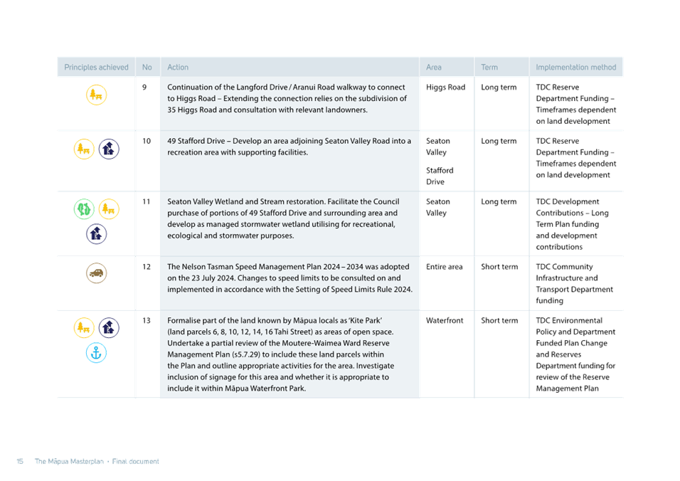
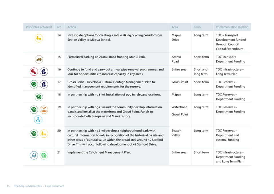
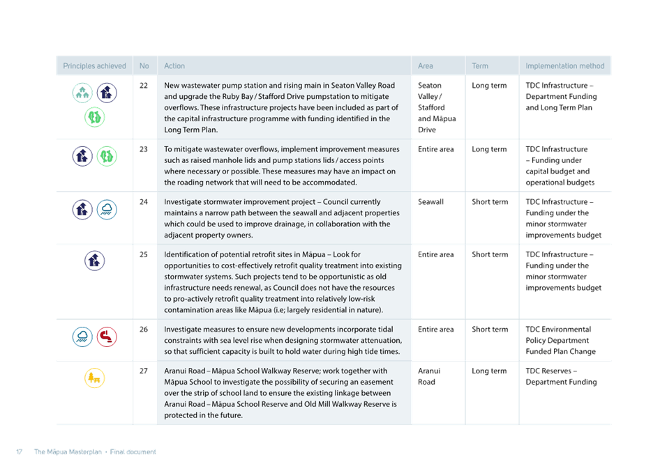
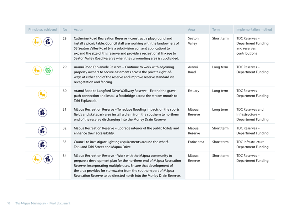
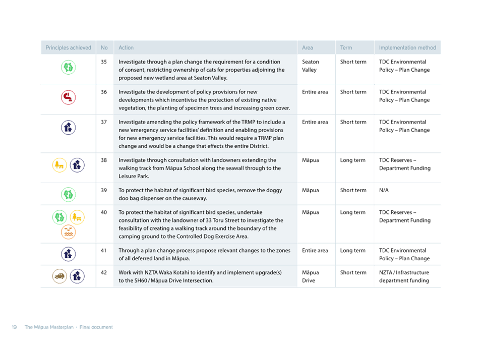
Tasman District
Council
Agenda – 14 August 2025
7.6 Private Plan Change Request - JL Palmer
Limited
Decision Required
|
Report
To:
|
Tasman
District Council
|
|
Meeting
Date:
|
14
August 2025
|
|
Report
Author:
|
Erin
Hawke, Policy Planner - Natural Resources
|
|
Report
Authorisers:
|
Barry
Johnson, Environmental Policy Manager
|
|
Report
Number:
|
RCN25-08-6
|
1. Purpose
of the Report / Te Take mō te Pūrongo
1.1 A
private plan change request to amend the boundary between the Wai-iti Dam
Service Zone and the Appleby Gravel Zone boundary, affecting Map 232B of the
Tasman Resource Management Plan (TRMP) has been lodged by JL Palmer Limited.
The Mayor and Councillors are asked to consider accepting the Private Plan
Change Request (PC86).
1.2 Approval
is also sought to notify PC86 within four months of agreeing to accept this
request as required by Schedule 1, Part 2 of the Resource Management Act, 2021
(RMA).
2. Summary
/ Te Tuhinga Whakarāpoto
2.1 Due
to the construction of the Waimea Community Dam water security within the
affiliated zones, including the Appleby Gravel Zone, has improved.
2.2 The
requester, J L Palmer Limited, owns land at 153 Palmer Road, Brightwater. His
bore WWD 24337 is located within the Wai-iti Dam Service Zone bordering the
Appleby Gravel Zone, shown in Figure 1 below.
Figure 1 - showing bore WWD24337 in
the Wai-iti Dam Service Zone and bore WWD24586 in the Appleby Gravel Zone
2.3 Bore
WWD 24337 is west of the confluence of the Wai-iti and Wairoa rivers. It is
approximately 360m from the Wai-iti River and 590m from the Wairoa River, shown
below in Figure 2.
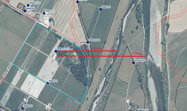
Figure 2 – showing the distances
of bore WWD24337 to the Wai-iti and Wairoa rivers
2.4 The
Wai-iti Dam Service Zone is not affiliated to the Waimea Dam. Instead the
Wai-iti Dam Service Zone is supplemented by releases from the Wai-iti (Kainui)
Dam using the same methods employed for the Waimea Community Dam and its zone
of benefit. The Wai-iti Dam Service Zone water supply is less secure. Water
users in the Wai-iti Dam Service Zone can experience frequent rationing and
cease takes during dry periods.
2.5 Over
time, the requester has noted that the water in bore WWD 24337 appears to be
influenced by the flow of the Wairoa River. It also appears to respond in a
similar way to another of the requester’s bores, bore WWD24586 which is
in the Appleby Gravel Zone approximately 210m to the north east of bore WWD
24337.
2.6 A
technical report by Aqualink validates these
observations. The Council’s Principal
Environmental Scientist for Water and Special Projects, Joseph Thomas, has
reviewed the Aqualink report and accepts that water from the Waiora River,
which is influenced by the Waimea Community Dam, likely extends underground to
bore WWD 24337.
2.7 The
current zone boundary follows Aldourie Road, which was drawn for the Waimea
West Zone boundary many years ago. The plan change requests that the Appleby
Gravel Zone boundary be redrawn along an old river terrace to provide some
hydrogeological control (see Attachment 2 - private plan change request map).
2.8 Written approvals to this
private plan change request (PC86) have been provided.
2.9 Council
staff have no concerns with the private plan change request and consider it
addresses the requisite statutory requirements to proceed to notification.
3. Recommendation/s
/ Ngā Tūtohunga
That the Tasman District Council
1. receives
the Private Plan Change Request - JL Palmer Limited report RCN25-08-6;
and
2. accepts Private Plan Change Request - JL
Palmer Limited pursuant to cl 25(2)(b),
Schedule 1 of the Resource Management Act 1991; and
3. approves public notification of Private
Plan Change Request JL
Palmer Limited within four months of this
decision.
The private plan change request
4.1 JL
Palmer Limited has lodged a request to amend Map 232B of the TRMP so that the
Appleby Gravel Zone extends southwest to encompass bore WWD24337. This would
enable JL Palmer Limited to take affiliated dam water from his bore WWD 24337
for which it holds water permit RM191377.
4.2 JL
Palmer Limited has observed that water levels are sustained within bore WWD 24337 even when the Wai-iti River runs dry, as
experienced in 2000/01 and 2018/2019 seasons.
4.3 Further
to this, they have noted that bore WWD 24337 responds similarly to their other
bore WWD 24586, located north of Aldourie Road, within the affiliated Appleby
Gravel Zone.
4.4 The
Aqualink report, which has been peer reviewed by Andrew Fenemor of Landcare
Research, validates these observations. The assessment is based on three
components:
4.4.1 bore stratigraphy and yields from five bores;
4.4.2 modelling of river flow responses in subject bores from
a fresh in the Wairoa River without influence from the Wai-iti River; and
4.4.3 modelling the zone of influence from modelled pumping of
bore WWD 24337.
4.5 Aqualink’s
technical assessment provides evidence of hydrological responses to Waimea
Community Dam flow releases in various bores that support an amendment to the
boundary of the affiliated Appleby Gravel Zone in the vicinity of Aldourie
Road. They consider this amendment would better portray the zone of effect from
flow releases from the Waimea Community Dam.
4.6 The
Council’s Principal Environmental Scientist for Water and Special
Projects, Joseph Thomas, has reviewed the Aqualink report and accepts that
water from the Waiora River, which is influenced by the Waimea Dam, likely
extends underground to bore WWD 24337.
4.7 The
Aqualink report recommends that the Appleby Gravel Zone boundary be redrawn
along an old river terrace to provide some hydrogeological control (see
attached private plan change request map).
4.8 Written
approvals to this private plan change request (PC86) have been provided by
Waimea Irrigators Limited, Waimea West Hops Limited, MG Group Holdings Limited,
Chaiman of the Wai-iti Dam Users Committee, and Ian Palmer. Written
approvals are not a requirement for plan change requests, however the requester
has been proactive in discussing the request with these parties and receiving
the approvals.
4.9 Fish
and Game New Zealand were approached but declined to provide their written
approval. They have concerns with what happens to the relinquished Wai-iti
water rights, which could easily be re-allocated further up the catchment.
4.10 The
Appleby Gravel Zone comprises the surface waters and groundwater in alluvial
gravels within the Waimea Plains in depths up to 15 metres and is affiliated to
the Waimea Community Dam.
4.11 In
Tasman, many of the shallow alluvial aquifers are replenished by leakage from
the rivers. This is the case with the Appleby Gravel Aquifer which is recharged
primarily by the Wairoa River and any dam releases from the Waimea Community
Dam.
Tasman Resource Management Plan
4.12 Resource
consents are required to take groundwater for irrigation and the relevant
Objectives and Policies relating to this are contained in Chapter 30 of the
TRMP. Relevant rules are within Chapter 31.
4.13 However, no changes are sought to any of the
written provisions in the Tasman Resource Management Plan (TRMP), only map
232B. Any changes to resource consents required to take water will be
addressed separately to the plan change.
4.14 The scope for the plan
change request is very narrow as the request only affects the Appleby Gravel
(affiliated) Zone. The boundary of the Wai-iti Dam Service Zone and the
(unaffiliated) Waimea West Zone will not change.
4.15 Any
changes to the unaffiliated zone boundaries can be considered when a full
review of the TRMP is undertaken once the resource management reforms and
national directions are gazetted, to rationalise the unaffiliated zone boundary
with the affiliated zone boundary.
4.16 If
the request is successful, the requester will require a new water permit under
the TRMP rules to take groundwater in the Appleby Gravel Zone from bore WWD
24337. In doing so he will be required to relinquish his access to groundwater
from the Wai-iti Dam Service Zone using the same bore.
Process for considering the private plan
change request (PC86)
4.17 The
requester has proposed that Part 2 of Schedule 1 of the RMA for private plan
changes be adhered to, rather than the freshwater planning process under s80A
of the RMA.
4.18 According
to the requester the basis for this request is:
Clause 6B(b)
of Section 80A states that a regional council may use the freshwater planning
process when preparing other provisions of a regional plan that relate to
freshwater.
Section 80A
clearly relates to plan process prepared or undertaken by a regional council
(clause 1). It does not provide for a plan change privately prepared and
requested.
4.19 Furthermore,
Section 80A relates to the freshwater planning process required to give effect
to the National Policy Statement for Freshwater Management 2020 (NPS-FM).
4.20 In
this instance, the plan change request seeks to change a water management zone
boundary. It does not seek to give effect to the NPS-FM. Consequently, the
general provisions for notifying a private plan change under Schedule 1, Part 2
of the RMA can be used.
Assessment of
environmental effects
4.21 The requester has provided
an assessment of environmental effects corresponding with the scale and
significance of the proposal and concludes there will be positive effects,
including:
4.21.1 more accurate data on the
use and allocation of water from the Waimea Community Dam, particularly on the
margins;
4.21.2 an additional
shareholder, and therefore additional funding for Waimea Irrigators Limited;
and
4.21.3 greater certainty and
reliability for the requester
in relation to a water supply for their orchard business.
5. Analysis
and Advice / Tātaritanga me ngā tohutohu
5.1 The
requester has provided a thorough plan change request including an Assessment
of Environmental Effects, s32 Evaluation Report, a Technical Assessment by
Aqualink, peer reviewed by Andrew Fenemor (Landcare Research) and Affected
Party Approvals.
5.2 Moving
the zone boundary will affect land owned by Tasman District Council (paper road
and river reserve), Waimea West Hops Limited and a strip of
unalienated crown land. It may have the effect of marginally increasing
rates for the land liable to rates but given the area is very small it may not
register a change.
5.3 Council staff have no concerns
with the private plan change request and recommend it be accepted by the
Council so that it can proceed to notification.
6. Financial
or Budgetary Implications / Ngā Ritenga ā-Pūtea
6.1 The
cost to progress this relatively minor private plan change request will be
borne by the requester if option 1 ‘Accept’ is chosen.
6.2 Staff
time required for administration, assessment of the application, and to assist
with the notification and submissions process can be charged to the requester
under option 1.
6.3 Time
for staff to assist with this private plan change request can be met from
within the current Environmental Policy team’s work schedule.
7.1 The options are outlined in the
following table:
|
Option
|
Advantage
|
Disadvantage
|
|
1.
|
Accept
|
· The Council administers the legal process and the costs are
largely borne by the requester.
· Accepting the request indicates that the
Council considers that there is enough information for it to be publicly
notified, not that the Council necessarily supports it.
· The s32 report, the Assessment of Environmental Effects and
description of the proposal have been completed by the requester and do not need replicating or
reworking.
· Is an example to other landowners who may want to proceed with a
similar type of private plan change, that the Council will not bear the costs
for these.
· Allows the Council to work with the requester to achieve the best
outcome.
· Ensures it remains a private plan change which is likely to be an
exemption to the Plan Stop being introduced in August via the
Government’s second RMA Amendment Bill when it is expected to pass into
law.
|
· The Council has less control to modify or
withdraw the request at a later stage, if required.
· Rules do not have effect until the plan is operative.[4]
|
|
2.
|
Adopt
|
· If the Council adopts a private plan change, it continues through
the process as if it was a Council-initiated plan change.
· Implies that the Council generally supports the proposal.
· Gives the Council greater control over what is notified.
· By gaining control of the process, it is possible to modify or
withdraw the request at a later stage, if required.
· Rules protecting or relating to water have an effect on
notification s86B RMA.[5]
|
· Implies the Council will bear the cost of managing the plan change
from the date that it adopts it.
· Councils only ‘adopt’ plan changes in rare
circumstances.[6]
· Works well when there is a component of
public benefit, because the ratepayers are bearing
the costs, but in this case the benefit is privately derived.
· Creates a precedent for future privately initiated plan changes.
|
|
3.
|
Reject
|
· There are no grounds for rejection as set out in Clause 25 (4) of
Schedule 1 of the RMA.
|
· Rejection would
expose the Council to a potentially successful legal challenge:
- it is
not frivolous or vexatious;
- the
substance of the change has not been dealt with by the local authority or the
Environment Court within the last two years;
- the
change is in accordance with sound resource management practice;
- the
change would not make the plan inconsistent with Part V (other policies and
plans); and
- the plan
to which the change is being made has been operative for more than two years.
|
|
4.
|
Resource consent
|
· No advantages
|
· The requested change could not be achieved through a resource
consent process as it relates to changing zone boundaries within the TRMP.
|
7.2 Option 1 is recommended.
8.1 The Council’s statutory
requirements in relation to a private plan change are contained within the
Schedule 1, Part 2, clause 25 of the RMA.
8.2 The two pragmatic options are to accept
or to adopt.
8.3 If PC86 is accepted it would follow the
procedures for notification set out in Schedule 1, Part 2, clause 26 and must
be notified within four months of the decision.
8.4 Following this procedure the plan change
will not have legal effect until it is operative, once any submissions or
appeals have been settled.
8.5 Recent
announcements by the Government indicate that they will put a stop to
unnecessary plan changes under the RMA. This will be done via an amendment to
the RMA Amendment Bill currently before the House.[7] However,
private plan changes are likely to be exempt.[8]
8.6 Despite
the announcements from Government, it was the Supreme Court’s finding in Fitzgerald
v Muldoon and Others that decisions must be made based on the law as it
currently stands, not on potential future legislative changes.
9. Iwi
Engagement / Whakawhitiwhiti ā-Hapori Māori
9.1 The Waimea
Plains area, including the waterways and coastal environment, holds significant
cultural, spiritual, historical and traditional values and associations for
Ngā Iwi o Te Tauihu.
9.2 Statutory
Acknowledgements over the Waimea, Wai-iti and Wairoa Rivers and their
tributaries are held by Ngāti Apa ki te Rā Tō, Ngāti Kuia,
Rangitāne o Wairau, Ngāti Kōata, Ngāti Rārua,
Ngāti Tama ki Te Tau Ihu and Te Ātiawa o Te Waka-a-Māui.
9.3 Ngāti Toa Rangatira hold a
Statutory Acknowledgement over the Waimea River and tributaries.
9.4 The requester has provided a
summary of the private plan change request to the eight Te Tauihu iwi.
9.5 On notification ngā iwi will
be provided with a copy of the full request. Clause 26, Part 2, Schedule 1 of
the RMA is silent on pre-notification regarding consultation for iwi
authorities.
10. Significance
and Engagement / Hiranga me te Whakawhitiwhiti ā-Hapori Whānui
10.1 The proposals in this paper have a relatively low
level of significance for the Waimea community. No significant community
involvement or consultation is required.
|
|
Issue
|
Level of
Significance
|
Explanation of
Assessment
|
|
1.
|
Is there a high level
of public interest, or is decision likely to be controversial?
|
Low
|
No
|
|
2.
|
Are there impacts on
the social, economic, environmental or cultural aspects of well-being of the
community in the present or future?
|
Low
|
Environment
By gaining water from
the Appleby Gravel affiliated zone the requester can
sell his shares in the Wai-iti Dam Service Zone. The zone is fully allocated
with a waiting list so this provides scope for new land in the Wai-iti to be
irrigated. This creates a minor cumulative effect to the groundwater resource
by adding a new user further up catchment. However, the groundwater resource
is protected by the allocation regime for both zones. The amount of allocated
water within the Wai-iti Dam Service Zone will not change. The Appleby Gravel
Zone is not fully allocated.
Cultural
There is unlikely to
be any cultural impacts or benefits, although part of the land being rezoned
is covered by Statutory Acknowledgements for Ngā Iwi o Te Tauihu.
Economic
There are economic
advantages for the requester and Waimea Irrigators Ltd. The requester will
gain more security of supply for his orchard business and potentially profit.
Waimea Irrigators Limited can sell their shares and help fund repayment of
the dam.
Social
There are unlikely to
be social impacts.
|
|
3.
|
Is there a
significant impact arising from duration of the effects from the decision?
|
Low
|
No
|
|
4.
|
Does the decision
relate to a strategic asset? (refer Significance and Engagement Policy for
list of strategic assets)
|
Low
|
The Waimea Community
Dam is a strategic asset. This proposal supports the Waimea Dam as another
investor is buying into the scheme.
|
|
5.
|
Does the decision
create a substantial change in the level of service provided by Council?
|
Low
|
No
|
|
6.
|
Does the proposal,
activity or decision substantially affect debt, rates or Council finances in
any one year or more of the LTP?
|
Low
|
No
|
|
7.
|
Does the decision
involve the sale of a substantial proportion or controlling interest in a CCO
or CCTO?
|
Low
|
No
|
|
8.
|
Does the
proposal or decision involve entry into a private sector partnership or
contract to carry out the deliver on any Council group of activities?
|
Low
|
No
|
|
9.
|
Does the proposal or
decision involve Council exiting from or entering into a group of
activities?
|
Low
|
No
|
|
10.
|
Does the proposal
require particular consideration of the obligations of Te Mana O Te Wai
(TMOTW) relating to freshwater or particular consideration of current
legislation relating to water supply, wastewater and stormwater
infrastructure and services?
|
Low
|
The allocation
regimes for the Appleby Gravel Zone and the Wai-iti Dam Service Zone protect
water for its ecological values and contributions to river flows. It
maintains a reservation for community drinking water. The remaining water is
then available for irrigation and consumptive use. Therefore, the obligations
of Te Mana o Te Wai are met.
|
11. Communication
/ Whakawhitiwhiti Kōrero
11.1 Environmental Policy staff have engaged with
Consents, Compliance, Environmental Science and Community Infrastructure in
deciding how to progress this plan change request.
11.2 The
requester has provided a summary of the application to Ngā Iwi o Te
Tauihu.
11.3 The
requester has also provided a description of the proposal to the following
parties, whom they consider to be affected by the request:
|
Name
|
Registration number
|
Address
|
|
Murray King (Director)
Waimea Irrigators Limited
|
6091410
|
|
|
Cameron Ealam (Chairman)
Wai-iti Dam Water Users Committee
|
|
|
|
Lawson Davey
Fish and Game New Zealand
|
|
|
|
Ian Palmer
|
|
155 Palmer Road
|
|
Ben Giesen (Director)
Waimea West Hops Limited
|
6854773
|
Lot 1 Aldourie Road
|
|
Kerry Wells
MG Group Holdings Limited
|
1544428
|
71 Aldourie Road, Waimea West
|
Table
1 – Affected parties identified by the requester
11.4 Notification
of PC86 will follow the prescribed timeframes and process under Schedule 1
clause 26 of the RMA.
11.5 No
prior communication with the public for this private plan change request is
required.
12.1 There are potential risks with Options 1 and 2 presented in this
paper.
12.2 In financial terms the risk is lower for
Option 1 than Option 2, as the requester will bear the cost of the private plan
change.
12.3 Environmentally the risks are low as the river
flows and groundwater levels are protected by limits and levels set in the TRMP
to protect ecological values and these will not change.
12.4 There is a waiting list for water permits in the
Wai-iti Dam Service Zone and if JL Palmer Ltd can utilise water from the Waimea
Dam, another user up-catchment may benefit from the Wai-iti Dam shares he will
no longer require.
12.5 The political risk of Option 1 is lower than
Option 2 as the Council is not seen as endorsing the proposal. During the
notification period the community has an opportunity to submit their views
through the submission, hearing and appeal process.
12.6 A private plan change is less likely to be
halted by Government under the indicative resource management reforms, which
lowers the potential risk for disruption to the process.
12.7 Once the zone boundary for the Appleby
Gravel Zone has moved south the requester will be required to apply for a water
permit or vary his existing water take permit RM191377.
12.8 A new permit will be a restricted
discretionary activity. A variation to a water permit is a discretionary
activity. Either way the takes can be conditioned so that the requester only
uses the water from bore WWD 24337 from one consent to irrigate the nominated
land area.
12.9 The aquifer boundary adjustment also
involves land owned by Waimea West Hops Limited. Waimea West Hops Limited
already has bores in the Appleby Gravel Zone with the associated benefits of
access to Waimea Dam water. It is unlikely they would seek another bore in this
area and if they did, a new water permit would be required.
12.10 The Appleby Gravel Zone is not fully allocated.
13. Climate
Change Considerations / Whakaaro
Whakaaweawe Āhuarangi
13.1 The private plan change
request requiring a decision in this report was considered by staff in
accordance with the process set out in the Council’s ‘Climate
Change Consideration Guide 2024’.
13.2 While greenhouse gas emissions are largely driven
by economic growth[9] the change to the Appleby Gravel Zone boundary will have little
impact. The change will enable JL Palmer Ltd to apply a more secure source of
water to their land, not necessarily enabling them to produce more apples.
13.3 Furthermore, the Council is committed to the Waimea
Community Dam and its associated water allocation regime. The effects on
climate change were presumably accounted for when the Dam and affiliated water
was consented.
13.4 When considering the effects of climate change on
the requester it appears that he is aiming to be more resilient by gaining
access to a secure water supply.
13.5 Consequently, this proposal does not detract from
the Council’s and Government’s plans, policies and legal
obligations relating to climate change (e.g. Tasman Climate Response Strategy
and Action Plan, Emissions Reduction Plan, National Adaptation Plan etc.).
14. Alignment
with Policy and Strategic Plans / Te Hangai ki ngā aupapa Here me ngā
Mahere Rautaki Tūraru
14.1 The Council has the delegations for decisions on
changes to the TRMP, and their associated plan development and plan making
processes under RMA Schedule 1.
15. Conclusion
/ Kupu Whakatepe
15.1 Considering the balance of legal, financial,
operational and reputational risks to the Council, staff recommend that the Private
Plan Change Request to amend the boundary between the Wai-iti Dam Service Zone
and the Appleby Gravel Aquifer (PC86) is ‘accepted’.
16. Next
Steps and Timeline / Ngā Mahi Whai Ake
16.1 Following the Council’s decision to adopt or
accept PC86 Council is required to publicly notify the plan change
request following the procedures set out in Part 2 of Schedule 1 of the RMA,
including the requirement to notify within four months of making that decision.
16.2 Within that time, staff will consult with
the requester, notify ngā iwi and people who may be directly affected by
the change request, and publicly notify it.
16.3 Upon notification there is a 20-working day
submission period, followed by a further 10-working day further submission
period.
16.4 A hearing will be held unless no submissions
are received and there are no concerns about the request.
16.5 At any time prior to making its decision
(either before the hearing or as a result of it), the Council can initiate a
variation to the change request with the agreement of the requester. Such a
variation would need to be publicly notified and the process would start again
from that point.
16.6 The requester and any person who made a
submission may appeal the decision of the Council to the Environment Court
within 30 working days.
|
1.⇩
|
Private
Plan Change Request to Tasman Resource Management Plan
|
767
|
|
2.⇩
|
Water Notification
Map PC86
|
831
|
Tasman District
Council
Agenda – 14 August 2025

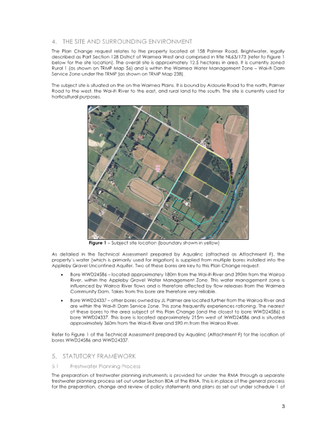
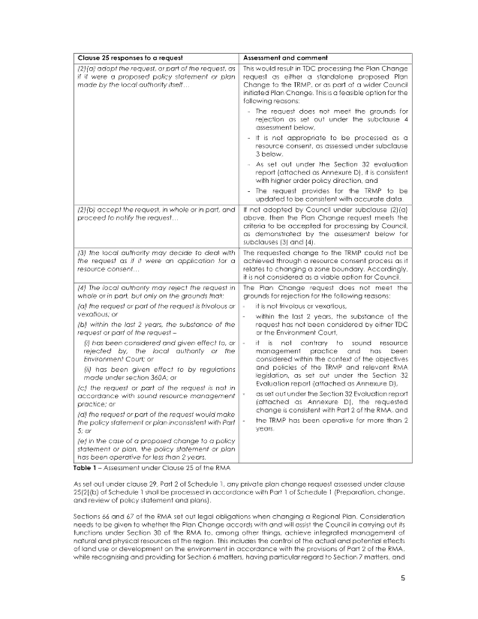

Tasman District Council Agenda – 14 August 2025