Notice
is given that an ordinary meeting of the Environment and Regulatory Committee
will be held on:
MEMBERSHIP
|
Chairperson
|
Cr C Hill
|
|
|
Deputy
Chairperson
|
Cr B Maru
|
|
|
Members
|
Mayor T King
|
Cr M Greening
|
|
|
Deputy Mayor S
Bryant
|
Cr C Mackenzie
|
|
|
Cr C Butler
|
Cr M
Kininmonth
|
|
|
Cr G Daikee
|
Cr K Maling
|
|
|
Cr B Dowler
|
Cr D
Shallcrass
|
|
|
Cr J Ellis
|
Cr T Walker
|
(Quorum 7 members)
Environment and
Regulatory Committee Agenda – 14 March 2024
AGENDA
1 Opening, Welcome, KARAKIA
2 Apologies
and Leave of Absence
|
Recommendation
That apologies be accepted.
|
3 Public
Forum
3.1 Vehicles
on Beaches Bylaw.................................................................................... 4
Registration is
required to speak at public forum. You can register here
4 Declarations
of Interest
5 LATE
ITEMS
6 Confirmation
of minutes
|
That the minutes of
the Environment and Regulatory Committee meeting held on Thursday, 23
November 2023, be confirmed as a true and correct record of the meeting.
|
|
That the confidential
minutes of the Environment and Regulatory Committee meeting held on Thursday,
23 November 2023, be confirmed as a true and correct record of the meeting.
|
7 Reports
7.1 Group
Manager's Report......................................................................................... 5
7.2 Resource
Consent Manager's Report................................................................... 14
7.3 Building
Assurance Manager's Report.................................................................. 25
7.4 Rivers
and Coastal Structures............................................................................... 33
7.5 Environmental
Information Manager's Report....................................................... 45
8 Confidential
Session
Nil
9 CLOSING
KARAKIA
Environment and
Regulatory Committee Agenda – 14 March 2024
3 Public
Forum
3.1
Vehicles on
Beaches Bylaw
|
Report
To:
|
Environment
and Regulatory Committee
|
|
Meeting
Date:
|
14
March 2024
|
|
Report
Number:
|
RRC24-03-1
|
1. Public
Forum / Te Matapaki Tūmatanui
Cynthia McConville, Forest and Bird Golden
Bay, will speak in public forum regarding a Vehicles on Beaches Bylaw.
Nil
Environment and
Regulatory Committee Agenda – 14 March 2024
7 Reports
7.1
Group Manager's
Report
Information Only - No Decision
Required
|
Report
To:
|
Environment
and Regulatory Committee
|
|
Meeting
Date:
|
14
March 2024
|
|
Report
Author:
|
Kim
Drummond, Group Manager - Environmental Assurance
|
|
Report
Authorisers:
|
Steve
Manners, Group Manager - Information, Science and Technology
|
|
Report
Number:
|
RRC24-03-2
|
1. Summary
/ Te Tuhinga Whakarāpoto
1.1 This report
serves as an update on environmental and regulatory activity since the last
Committee meeting on 23 November 2023.
2. Recommendation/s
/ Ngā Tūtohunga
That the Environment and
Regulatory Committee
1. receives the Group Manager's Report RRC24-03-2.
3. New
managerial appointments within the Environmental Assurance Group
3.1 Harbourmaster: We welcomed our new Harbourmaster, Peter Renshaw on 11 December
2023. Peter has extensive experience in maritime management and a deep
commitment to ensuring safety and compliance in coastal and navigable
waterways.
3.2 Peter was most
recently a Maritime Tutor at Te Kupenga, and before that a Vessel Operations
Manager at Abel Tasman Sea Shuttle. He lives in Motueka and will be based in
the Harbourmaster Office at Port Motueka.
3.3 The
Harbourmaster now reports directly to the Group Manager - Environmental
Assurance and will be responsible for providing six-monthly reports to this
Committee. The first of these reports is scheduled for 24 April 2024.
3.4 Regulatory
Manager: We also have a new Regulatory Manager who
started 20 January 2024 - Shane Bruyns. Shane has 25 years’ experience in leadership roles
across both the Christchurch City Council and the Cape Town City Council, with
a short stint with the Department of Corrections in between. Prior to that he
had entered the workforce as a fitter and turner before a change of focus saw
him divert towards a Council career.
3.5 Shane will also
report to the Committee on a six-monthly basis, mainly covering the areas of
environmental health and the performance of contracted services. His staff will
report separately on dog control, wastewater, dairy farm monitoring, compliance
and enforcement, and water use monitoring.
4. New
Government’s legislative and policy priorities
4.1 The new National-led coalition
Government has set out its priorities for its first 100 days, through to 7
March 2024. The commitments included repealing legislation introduced by the
previous Government in their final year of office. That resulted in both the
Natural and Built Environment Act and Spatial Planning Act being repealed on 20
December 2023.
4.2 Phase two of the Government’s
reform agenda in the environmental management space involves the development of
fast-track consenting legislation and specific changes to the Resource
Management Act (RMA) in line with the two coalition agreements that are in
place. Those agreements can be interpreted as providing four key platforms to
work from: farming economy, housing growth, infrastructure growth and
renewables.
Fast track consenting bill
4.3 On 31 January 2024 the Minister
Responsible for RMA Reform wrote to Mayors and Chairs to advise of the initial
steps for implementing phase two of the reform agenda. Specific mention was
made of the proposed fast-track consenting bill, which would lead to a
standalone Act with its own purpose statement, and prioritise locally,
regionally, and nationally significant infrastructure and development projects.
There will be a process for the responsible Minister to refer projects for
acceptance to an Expert Panel.
4.4 Council staff were given a short period
of time to respond to an opportunity to identify projects which could be
considered for fast-track consenting. At the time of writing, we had no further
contact with officials but were expecting a bill to be introduced into the
House. This may well have happened by the time the Committee meets.
4.5 The Minister has signalled that there
will likely be an opportunity to provide feedback through a select committee
process some time in March, and shortly after introduction of the fast-track
consenting bill.
Changes to the NPS-FW
4.6 In relation to phase three of the reform
agenda, the Minister had previously written to Chairs and Mayors on 13 December
2023 to advise of his intentions to review and replace the National Policy
Statement for Freshwater Management (NPS-FM) in this parliamentary term. This
was to be done through the RMA process for developing and amending national
direction.
4.7 In the 31 January 2024 letter, the
Minister acknowledged that developing and amending national direction would
take time. So as an interim step the deadline for councils to notify freshwater
planning instruments to implement the NPS-FM had been extended by three years
– which means it is now set down for December 2027.
4.8 In the lead up to the Government’s
announcement, regional and unitary councils had undertaken a stocktake of where
each Council was at, in relation to the December 2024 deadline, and it was
apparent that many would have struggled to comply. Notwithstanding those that
were having difficulty complying, some were running ahead of the timeframe and
may choose to notify their plans well ahead of the new deadline.
Changes to Te Mana o te Wai
4.9 The 31 January letter also set out a
commitment from the Minister to progress changes to how the hierarchy of
obligations contained in Te Mana o te Wai provisions of the NPS-FM apply to
consent applications and consent decisions. The stated intention was for these
changes to be made through a separate RMA amendment bill this year. This step
can be interpreted as being part of phase two, with the wider review of the RMA
coming in under phase three.
Freshwater Farm Plans
4.10 The coalition Government has signalled an intention
to improve freshwater farm plans (FWFPs) to ensure they are pragmatic and cost
effective. Regulations now apply to parts of Waikato, Southland, West Coast and
Otago regions, and are scheduled to apply to parts of the Whanganui/Manawatu
region from 1 April 2024.
4.11 For additional regions to go live there would need
to be an Order in Council (OIC) made for this to happen and indications are
that there are no immediate plans for an OIC to be made for that purpose.
Instead, it seems likely that the review to identify improvements required will
be undertaken before the roll out recommences.
4.12 In the meantime, councils who have already begun to
implement the FWFP system will continue to be supported by the Ministry for the
Environment with their implementation efforts. It is expected that further
clarity will be provided by the end of March.
4.13 From a Tasman perspective, we see benefits in
aligning the expectations coming out of a revised NPS-FW with the formal
activation of the FWFPs in our district. It is essential that the FWFP is
embedded into the required Freshwater Plan as that is where the minimum
standards and expectations to be achieved will be set out. This is particularly
important if we continue with not requiring land use consents to farm but defer
to permitted activities as the primary tool in our plan.
4.14 If both deadlines are aligned, we will be better
positioned to communicate a clear message on the content of FWFPs as we roll
them out across our district. We anticipate there will be a standalone
section/appendix in the new Freshwater Plan that will table how and when FWFPs
give effect to the Freshwater Plan. Landowners could then use that appendix as
the basis for ensuring they are meeting all requirements, rather than having to
read the entire Freshwater Plan or pay a consultant to find the relevant bits
for them.
Aquaculture
4.15 The Ministry for Primary Industries is exploring a
range of options to improve aquaculture management and address perceived
regulatory barriers. The objective of this work is to make it easier to consent
new aquaculture activities thereby better enabling the growth of the primary
sector.
4.16 Officials have signalled they are and will be
working with agencies, industry, councils, and iwi representatives to explore
options to improve aquaculture management and improve certainty for farmers.
This will include identifying:
4.16.1 How aquaculture marine projects could be included in
permanent fast-track one-stop consenting regime currently in development,
4.16.2 Effective ways of delivering greater certainty to
existing marine farms by extending consent durations, and
4.16.3 How national direction could improve aquaculture
management and give greater certainty to farmers.
4.17 As
part of this work, officials have provided Council staff with a one-pager
outlining a proposal to extend the duration of existing consents for marine
farming. Feedback was requested within six working days, and we were able to
provide a 45-minute briefing four days into that deadline.
4.18 The
Council context for these discussions is that there are 71 active consents in
Tasman and Golden Bays, where most of the aquaculture occurs within three
Aquaculture Management Areas (AMAs). Outside of the AMAs we have eight farms in
Wainui Bay that are restricted to mussel spat production – and they
provide an important source of spat for the mussel farming industry (supplying
60% of spat used within Te Tau Ihi and 30% nationally). These consents are due
to expire on 31 December 2024 and must be reapplied for within six months of
that date. In total, 12 of the 71 consents are due to expire within the next
five years (including the eight in Wainui Bay).
4.19 A
brief submission to the MPI request was provided by the due date of 4 March
2024, although it was later in the day than the requested 12 pm deadline. The
submission commented briefly on the proposal under the headings of consent
extension, lacking in detail, consultation period too short, spat catching
sites in Golden Bay, and consideration of climate change. Our submission
concluded by emphasising that we would like to work with officials to find ways
and means of ensuring aquaculture has a sustainable future in our district.
4.20 Running
alongside the work our staff put into responding to MPI, the Resource Managers
Group (part of Te Uru Kahika) sought comment from across their network. They
drew on Ngā Kairapu as well as the Consents, Policy and Coastal Management
special interest groups (SIGs). In summary, Te Uru Kahika are keen to work with
MPI (and MfE) in progressing the next steps in achieving a thriving aquaculture
sector, and more specifically in the process for determining marine farm
consents’ durations. The Te Uru Kahika Director for Resource Management
Reform noted that the feedback supplemented, but did not override, submissions
from individual member councils.
4.21 In
order for the Committee to gain a better appreciation of the potential for
aquaculture in our district, we have approached Aquaculture New Zealand, the
Marine Farming Association and an Iwi Aquaculture Organisation representative
to present to the Committee as part of the public forum at the meeting
scheduled for 6 June 2024.
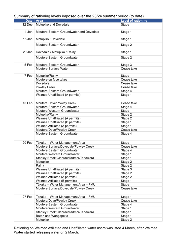
5.1 As 2023 came to an end it was apparent
from most weather forecasting models that Tasman was heading into an extended
period of dry weather. This prediction was driven by a La Niña weather
pattern. As a consequence, an earlyish meeting of the Dry Weather Task Force
(DWTF) was convened on 12 December 2023 and the first of a series of rationing
decisions was made. The key function of the DWTF is to support the Council in
the issuing of water shortage directions at any time that there is a serious
temporary shortage of water in the district.
5.2 A decision was taken not to convene the
task force over the summer break as the restrictions required to manage water
takes over that period were relatively non-controversial and required to ensure
environmental flows. However, the task force did meet weekly during the month
of February and additional rationing steps were taken across the district. A
summary table of the decisions that have been taken that restricted otherwise
consented takes is attached as an appendix to this report. In addition, some
exemptions were authorised to enable public supply to continue, subject to
restrictions imposed to ensure adherence to reduced limits.
5.3 On the weekend of 2-3 March, Council was
informed that the Waimea Dam was releasing water at a greater rate than was
required to meet environmental flows. Downstream flow measurements subsequently
confirmed that sufficient water had been released to enable consented takes to
be fully reinstated. An order to this effect was made on Monday 4 March. At
that time the district was also benefiting from moderate rainfall and it the
need for further restrictions would be greatly diminished.
5.4 However, the outlook continues to be or
minimal rain through until the next scheduled meeting of the DWTF on 12th
March. The case for further rationing will need to have been considered at that
time and a verbal update will be available for the Committee on any decisions
taken.
6. Progress
towards an operational Waimea dam
6.1 Progress with the commissioning of the
Waimea Dam was slower than initially hoped and so the dam was not able to
release water to supplement environmental flows until the weekend of 2-3 March
(as noted above). This was enabled by the fitting of the first of three
permanent pipes that will in time will work together to enable the flushing
flows required from a fully commissioned dam.
6.2 The actual commissioning of the dam will
require a commissioning report to be submitted to, and approved by, the
regulatory arm of Council. Following that, there will be changes to the levels
of water take that are authorised, depending on whether consent holders are
affiliated to Waimea Water Limited or not.
6.3 In order to be ready for the go
live state, required water consent monitoring (WCM) real-time rationing
pro-rated and (text) notifications systems are about to be deployed, so that
live environment testing can be completed. Then once the dam goes operational,
the notification function will be turned on for all users.
6.4 Accompanying the text
notifications is an automated email system. This is in the final stages of
completion – once that piece of work is complete, we will do live
environment testing.
6.5 The below table shows a consent
going into 50% rationing mid-week. In this scenario, we would ignore
‘last week’ and provide the user with ‘this week’. An
email sent on Thursday (highlighted in the table in blue) tells them that their
maximum take for ‘this week’ is 500m3.
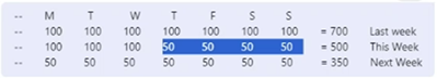
6.6 The following Monday the user
would automatically receive an email that tells them their maximum take for
‘next week’ is 350m3 which is a 50% reduction of their entire take
(unless another ration step is triggered, and it will recalculate the pro-rata
allowed take).
6.7 The new arrangements that apply
to an operational dam are going to take some time for all our consent holders
to get used to. Accordingly, we have allowed for staff time to assist with
education and support as they adjust.
7. Upcoming
changes to regulation of dams
7.1 While we are close to having an
operational dam that is 50% owned by the Council, there are upcoming changes to
the regulatory framework that applies to dam owners. The new arrangements
assume that Council has a Dangerous Dams Policy. The Council commenced the
development of such a policy some years ago, but the policy development process
was not completed.
7.2 The draft Dangerous Dams Policy is
currently in preparation for a special consultative process required under the
Local Government Act 2002. Once consultation is concluded, the Policy will be
put to Council for adoption. This is timetabled to happen prior to commencement
of the Building (Dam Safety) Regulations 2022 that are scheduled to come into
effect on 13 May 2024.
7.3 The intention of the regulations is to
ensure that classifiable dams are well operated, maintained and regularly
monitored. They also ensure that potential impacts of dam incidents and
failures are reduced, protecting people, property, and the environment.
7.4 Dam owners will first need to determine
if they have a classifiable dam. The regulations currently describe the
threshold for a classifiable dam:
· Four metres or higher with a volume of 20,000m3 or more, OR
· One metre or higher with a volume of 40,000m3 or more.
7.5 Dam owners are required to classify and register their dam/s within
three months of the regulations commencing or, if the dam is being built during
that time or later, within three months of the dam being commissioned. A
Potential Impact Classification (PIC) must be certified by a recognised
engineer and submitted to the Regional Authority for approval.
7.6 The
PIC will establish the dams as having a low, medium or high potential impact,
should a failure occur.
7.7 Following
the approval of a PIC, a Dam Safety Assurance Programme (DSAP) must be provided
to the authority within specific time frames as determined by classification;
for Medium (two years) and High (12 months). DSAPs must also be certified
by a recognised engineer. However, a DSAP will not be required for those dams
holding a low PIC.
7.8 Where
a DSAP is required, it will include the following:
· Dam and reservoir operation and maintenance
· Surveillance procedures
· Inspection and maintenance of appurtenant structures and inspection
and maintenance, testing of gate and valve systems with dam safety functions
· Intermediate dam safety reviews
· Emergency planning and response
· Identifying and managing dam safety issues.
7.9 Community
engagement will be initiated, planning the development of systems and
procedures will be implemented. Development of systems to receive /address
DSAPs and PIC reviews (within five years of PIC approval) can occur post
commencement of the regulations.
8. Assessment of the Resource Consent and
Building Assurance reports
8.1 Today’s
agenda includes reports from the Resource Consent and Building Assurance
Managers. They both signal a drop off in consent applications to the Council
during the 2023-24 year, in comparison to recent years. In the case of resource
consents, this drop-off has allowed the team to reduce the backlog of
applications that had built up due to capacity constraints. However, in the
case of building consents there is no back log and so the volume of cost
recoverable work has been less than budgeted for.
8.2 Staff
have evaluated the reasons for the drop off in applications, and considered
wider macro-economic factors that may indicate when the demand is likely to
return to the levels the respective section budgets are based on. This is
important for these sections as both rely on a high level of user funded
services.
Building Consents
8.3 Nationally
building consents have been tracking down since mid-2022. Latest numbers
(available for January 2024) – both seasonally adjusted and actual have
gone down. Tasman’s building consents started to dip in late 2022,
indicating a slight lag behind the national trend.
8.4 The
number of new dwellings consented per 1000 residents has been dropping
nationally. Tasman has done better than the national average for this indicator
in both 2022 and 2023 (when we were the third highest) but is faring slightly
worse in 2023 (seventh).
8.5 Various
forecasts for building consents exist, but the most common projection is for a
pick-up in 2025. The Building Assurance Manager notes the apparent
inevitability of a national upswing due to the high number of immigrants into
the country and the decline in new dwellings being built. The internal view is
that we can expect to see something of a pick-up later in 2024, but not
returning to a threshold of 400 per annum until 2027. Tasman’s 10-year
average has been 436 dwellings per year.
Resource consents
8.6 There
is less information available to support predictions of the number of resource
consent applications we can expect to receive in the near future. This is in
part due to the oscillating legislative and regulatory environment which at
various times has been aiming for greater legislative prescription (and
therefore less of a need for consents) or the current approach of fast-tracking
significant applications through a process set out under a new Act.
8.7 The
National Policy Statement for Urban Development annual monitoring report has
been monitoring residential subdivision consent applications. These have been
tracking down since 2019. Internally staff are seeing a drop off in the volume
of resource consent applications since late 2023, with an expectation this will
last until the middle of 2024. This suggests there may be a knock-on effect for
building consents and so the expected pick up in late 2024 may be delayed.
9.1 Red
Eared Slider Turtles: We have at least one Red Eared Slider turtle in Lake
Killarney. Red Eared Slider turtles are considered one of the hundred most
invasive pest species in the world. Because of their omnivorous diet they
could adversely impact aquatic plants, insects, eels, small fish species and
ground-nesting birds. Red Eared Slider turtles are an eradication pest species
in our Regional Pest Management Plan and as the management agency we are
required to eradicate them from the district.
9.2 All
residents on the western side of the lake have been spoken to, and the team at
Abbeyfield and have also consulted with Iwi. Everyone is aware that these
turtles are an issue and supportive of the control programme.
9.3 Staff
also plan to do a post on social media to inform people of the risks of
releasing these turtles into the wild. Our timing is good as it coincides with
a push from DOC and MPI about turtle education. Staff will use a specifically designed live capture trap that
will be monitored frequently and once the turtle is caught it will be
euthanised.
9.4 Possums, rats and stoats:
in the first half of this year, from February onwards, Vector Free NZ is
carrying out a three-part 1080 pest control operation in the Cobb, Parapara
& Gouland areas, in the Kahurangi National Park. It covers 155,000
hectares.
9.5 This work is being done to control pests
in the region including possums, rats, and stoats. Native species that are
under threat from these pests include tuke (rock wren), whio (blue duck), roroa
(great spotted kiwi), kea, kaka, and eight species of giant snails. The area is
also home to three species of native mistletoe.
|
1.⇩
|
Summary of
rationing decisions for the 23-24 summer season
|
13
|
Environment and
Regulatory Committee Agenda – 14 March 2024
Environment and
Regulatory Committee Agenda – 14 March 2024
7.2 Resource Consent Manager's report
Information Only - No Decision
Required
|
Report
To:
|
Environment
and Regulatory Committee
|
|
Meeting
Date:
|
14
March 2024
|
|
Report
Author:
|
Katrina
Lee, Resource Consents Manager
|
|
Report
Authorisers:
|
Kim
Drummond, Group Manager - Environmental Assurance
|
|
Report
Number:
|
RRC24-03-6
|
1. Summary
/ Te Tuhinga Whakarāpoto
1.1 This report summarises the performance of the Resource Consents
Section, within the Environmental Assurance Group, for the period July to
December 2023. A drop off in consent applications has occurred since
about October 2023. This has allowed us to clear some backlog and make good
progress on identifying and initiate actioning of a range of process
improvements.
1.2 Statutory timeframe performance for the reporting period was at 55%
compliance across all consent activities, but for the majority of the consents
that we have processed (i.e. land use) compliance was at 60%. In cases where
statutory timeframes have not been met, discount penalties provided for in the
legislation have applied.
1.3 In
recent times the trend has been for the quantum of discount penalties to have
doubled each year for the past three years, but this trend appears to have been
arrested. This is a big positive for the Section. The key drivers for the
discount penalties that are being incurred can be put down to three main
drivers:
· It continues to be
difficult to attract and employ experienced and competent consent planners who
can work within statutorily imposed timeframes.
· Engaging
experienced contractors has also been a struggle, and when we do, they are
generally not locally based. This places additional challenges on team leaders
to manage quality of output in a timely fashion.
· More and more
complex issues seem to be coming over our desks. This seems to be at odds with
the former Government’s claims that there will be less of a need for
consents under a simplified legislative structure. The legislation that they
passed did not seem to support this assumption, and has now been repealed.
1.4 The volume of consent applications received has increased during
this reporting period and notwithstanding the failure to meet statutory
timeframes, we are improving our efficiency and effectiveness. During the same
period for 2022/23, we had a list of 100 unallocated consents but this time
around we were at 37. This shows we are making progress towards being able to
process consents as they arrive.
1.5 As a result of still holding vacancies in the team we have been
continuing to contract out consents that we would prefer to process inhouse.
However, over this reporting period we have seen a reasonable improvement in
the recovery of costs associated with using contractors.
1.6 We now
have four graduates, after one graduate progressing through to a consent
planner position. We have secured a senior planner in the natural resources
team and about to advertise again for a senior planner in the land use team. We
are also recruiting for a Team Leader Development Engineering and a Development
Engineering Officer.
1.7 The team does not only process resource consents. A considerable
amount of our time is also spent responding to public enquiries (duty planning)
and LGOIMAs (information requests). Responding to service requests and
pre-applications can take consent planners away from consent processing, but it
is an investment that is likely to improve the quality of applications that do
come through to us.
1.8 We also have multiple staff in the resource consents team that are
involved in commenting and contributing to building consents, Project
Information Memorandums (PIMs) and Land Information Memorandums (LIMs). These
additional statutory processes also have tight audited timeframes and staff
need to meet those demands – along with LGOIMA responses, responding to
complaints and service requests.
1.9 We continue to service the Tākaka office through a contractor
(for land use consents), and this is working reasonably well. We will need to
review this before April due to this contractor going on leave for a number of
months.
1.10 In
summary, while we are still facing challenging times, the output of the
consents team needs is delivered against the backdrop of a range of factors.
2. Recommendation/s
/ Ngā Tūtohunga
That the Environment and Regulatory Committee
1. receives the Resource Consent Manager's Report RRC24-03-6.
3.1 This report presents the performance
results for the Resource Consents section for the first half of the 2023/24
financial year, from July to December 2023. It also provides some comparisons
from previous periods. It is a snapshot of current workload; staff resourcing
and shows where the section is sitting alongside our budget expectations.
4. Performance reporting July to December 2023
4.1 A
total of 516 applications for resource consents and other statutory
applications were received in the reporting period July to December 2023, the
six-month period before this was 470. A total of 434 decisions were made during
this six-month period, compared to 367 last year.
This is outlined in Table 1 below.
4.2 This
tells us that we have received more applications and issued more decisions
during this reporting period.
4.3 There
are currently 562 active consents still to be processed through to a
decision. This is a reduction in our backlog since the last reporting
period. This number does also include objections received, mainly for
water permits and time extensions to extend durations on existing consents. It
also includes a consent on long term hold awaiting on further information
requests.
Table 1: Non-notified consents July to December
2023
|
Type of
Application
|
Number
Complete Jul-Dec 21*
|
Number
|
Number
|
Number
|
Number
complete
|
Percentage
Within Time (Incl s37)
|
Median
Processing Days**
|
|
Complete
Jan- June 22*
|
Complete
July-Dec 2022
|
Complete
Jan-June 2023
|
Jul-Dec
2023
|
|
District
Land
|
282
|
246
|
213
|
207
|
233
|
60.09%
|
33
|
|
CN Variations
|
17
|
10
|
13
|
6
|
15
|
53.33%
|
41
|
|
Subdivision
|
79
|
50
|
53
|
40
|
68
|
30.88%
|
62
|
|
Coastal
|
7
|
5
|
6
|
24
|
6
|
50.00%
|
58
|
|
Discharge
|
79
|
57
|
75
|
54
|
67
|
46.27%
|
54
|
|
Regional
Land
|
37
|
10
|
17
|
12
|
10
|
50.00%
|
64
|
|
Water
Permit
|
73
|
44
|
45
|
24
|
35
|
94.29%
|
15
|
|
Total:
|
574
|
422
|
422
|
367
|
434
|
55.53%
|
39
|
|
SHA
Consents
|
0
|
3
|
1
|
0
|
2
|
100%
|
15
|
|
Boundary
Notices
|
16
|
34
|
27
|
14
|
23
|
34.78%
|
14
|
|
Others***
|
14
|
12
|
19
|
20
|
17
|
N/A
|
N/A
|
|
* The
numbers shown include applications to change conditions of existing consents
(variations)
|
|
|
**
Processing days are statutory working days including time extensions.
|
|
|
***
Others include Right of Ways, Outline Plans and Certificates of Compliance
|
|
|
|
|
|
|
|
|
|
|
4.4 The
timeframe compliance for the period has dropped further away since the last
reporting period. This is primarily reflective of a lack of planner resources,
especially in the senior space. This capability is especially required for peer
review internal work and mentoring of inexperienced staff. Despite this there
has been an increase in applications received and decisions issued year on
year.
4.5 Table
1 shows that the timeframe compliance for subdivision consents processed
through to a decision has improved since the last reporting period (17% were
within statutory timeframes last reporting period compared to 30%). We expect
this trend of improving performance to continue.
Table 2: Notified Applications July
to December 2023
|
Type of
Application
|
Number
Complete Jul-Dec 21
|
Number
|
Number
|
Number
|
Number complete
|
Percentage
Within Time (Incl s37)
|
Average
Processing Days*
|
|
Complete
Jan-June 22
|
Complete
July-Dec 22
|
Complete
Jan-June 23
|
Jul - Dec 2023
|
|
Publicly
Notified (no hearing)
|
0
|
0
|
0
|
0
|
0
|
N/A
|
N/A
|
|
Publicly
Notified (with hearing)
|
0
|
3
|
0
|
7
|
0
|
N/A
|
N/A
|
|
Limited
Notified
|
21
|
16
|
13
|
10
|
7
|
71.43%
|
73
|
|
(no hearing)
|
|
|
|
Limited
Notified
|
9
|
1
|
0
|
5
|
2
|
0.00%
|
195
|
|
(with
hearing)
|
|
|
|
Totals
|
30
|
20
|
13
|
22
|
9
|
55.55%
|
134
|
|
*
Processing days are statutory days including time extensions. The
timeframe for notified applications includes a variety of time
|
|
|
extensions
such as resolving issues with submitters, agreements for hearing dates and
adjourned hearings.
|
4.6 Table
2 shows that the percentage of limited notified consents processed within
timeframe for nine consents (with or without a hearing) was 55%. This is a low
compliance rate, but an improvement on the last reporting period. The
seven limited notified consents related to four developments as they were
bundled consents across subdivision, land use, discharge permits and a consent
notice variation.
4.7 For
this period, the timeframe compliance dropped by 9%, but the total amount of
discount penalties did not increase. Discount penalties are awarded as a 1%
refund of total consent costs, for each day that is over the statutory
timeframe, to a maximum of 50% (50 days).
Table 3: Discount Penalty Payments
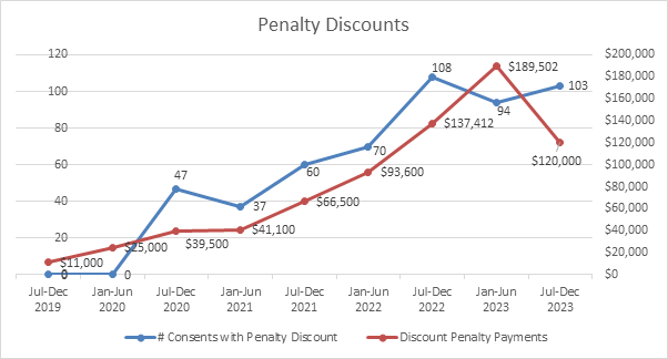
4.8 Of
the 103 consents that received a discount penalty this reporting period, 29 of
these were bundled consents (i.e. across district and regional council
consents). Twenty seven percent of the 103 were a 30% or above discount, but on
average discount percentage was 20%.
4.9 Table
3 shows a reduction in discount penalties paid out. However as explained in the
last reporting period, there was one consent that was 44% of the total discount
penalties. Therefore, if we remove that one consent from the last
reporting period, we paid out the same discount penalties, on average, this
reporting period.
4.10 Some
of the reasons for the discounts and timeframes relate to:
· Allocating and
finding experienced planners to process has been one of the most difficult
tasks for a number of years
· Because of the
less senior planners this has led to a shortage and ultimately delays in peer
reviewing letters/decisions that are sent out. This peer review work is
required for quality purposes to ensure a robust decision-making process
· Complex
applications and issues, including consent conditions and affected parties
· To ensure we make
informed decisions we rely on a number of internal staff to comment on resource
consent applications. However due to staff outside the consenting team having
other workload deadlines etc these comments can be delayed. As a result,
this impacts the statutory timeframes
· Multiple/bundled
consents being processed at once with many overlays (i.e. hazards, contaminated
soils, coastal, wetlands, highly productive land etc)
· Staff turnover and
handing over consents to new processing planners
· Managing contract
planners and ensuring overall consistency across decision making
· Managing and
interpreting National Policy Statements (NPS’s) and National
Environmental Standards (NES’s), and at times being seen as the
knowledge-holders for some of the consultant planners that are lodging resource
consent applications on behalf of applicants.
4.11 Some
of these consents started before this reporting period but were issued during
the reporting period. Since October 2023, we have maintained the unallocated
list to be relatively low (currently sitting at 35) compared to the previous
two years. This result represents progress.
5. Public enquiries (service requests)
5.1 The
overall number of public enquiries we have completed through the service
request system has remained steady over the last 12 months, with an increase in
enquiries to respond to in two teams – land use and natural
resources. The January to June 2023 period showed 1,288 service requests
for the entire resource consents team and this period 1,547. Refer to
table 4 below.
Table 4:
Service Requests Completed
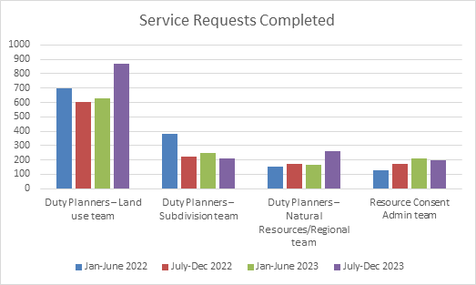
5.2 As
of February 2024, the service request enquiries across the resource consent
section are considered to be at a manageable level. This means that
planners are prioritise consent processing, rather than being drawn into
responding to service requests.
6.1 During
this reporting period here was one new appeal to a consent decision, received
July 2023, one hearing held on a subdivision and a mediation meeting. This is outlined in table 5 below but more detailed under
section 8 of this report.
Table 5: Appeal in
progress.
|
Application
|
Status
|
|
Application by CJ Industries Limited for
gravel extraction at Peach Island, Motueka
(RM200488 and others).
|
Commissioner decision to decline this
application was issued 29th of June 2023 and an appeal was lodged
by the applicant on 21st of July 2023. Mediation occurred December
2023. More details under section 8.1 of this report.
|
|
Application by Smit, for a subdivision at
Redwood Park Road, Redwood Valley
(RM230081 and others).
|
A rural residential subdivision to
subdivide into two allotments was limited notified 12 July 2023 and
submissions closed 24 August 2023. We received three submissions and hearing
was held 24 November 2023. Decision to grant subject to conditions was
released 9 February 2023 and the appeal period is open until 1 March 2024.
|
7. Water permit renewals / objections
7.1 Tākaka
(water management) Zone: The last staff update for the Tākaka
Zone was of seven applications for new water (i.e., for irrigation use)
currently on hold (subject to the provisions of NES Freshwater). They continue
to remain on hold in accordance with the provisions of the then proposed (19
October) gazetting of the Te Puna Waiora o Te Waikoropupū Springs and the Wharepapa Arthur Marble Aquifer Water Conservation
Order (WCO). Today the NES Freshwater is subject to the new
Government’s review and implementation of the WCO is front of
staff’s mind. The WCO provides for granting of new water permits up to a
limit of 766 L/sec subject to:
(i) no increase the concentration of N in the WAMARA (8(1a)); OR
(ii) not cause exceedance of the DRP limit in Fish Creek Springs or
Main Spring (8(2)); OR
(iii) not cause exceedance of DO and clarity limits in the Main spring
(8(3)).
Section 6 of the
WCO refers to Duties of Council and we need to understand how iwi choose to be
involved in this process. These implementation challenges need to be resolved
before we can grant any additional water.
7.2 Waimea
(water management) Zone: The Waimea East Irrigation Company (WEICo)
decisions RM170207 (& RM170207) were issued in October 2023 and the (s357)
objections received are yet to be heard.
With WEICo’s objection there
are now outstanding Waimea objections (s357) as follows:
· Relating to one
applicant, there is one outstanding complex (Reservoir Zone) objection relating
to an affiliated consent (and three related objections to damming, excavation
of gravel seepage holes etc) in this Waimea zone of benefit (S124 applies); and
· Two
outstanding objections relating to unaffiliated consent decisions in Waimea
West Zone and Redwood Valley Irrigators (RVI) in Delta Zone (S124 applies to
both). As reported previously, Council staff have responded to both objections.
Staff are currently discussing part affiliation of the RVI as a recognised
irrigation scheme.
While not objections, 12
applications (involving multiple affiliated permits & holders) remain
unprocessed, in the run up to a joint allocation sharing framework.
7.3 Redwood
Zone: One objection was resolved in the last period, but five objections
are still outstanding relating to the TRMP rezoning of the zone of benefit
(Waimea Dam). There has been no recent contact with these applicants.
7.4 Aorere/West
Coast (water management) Zone: There continues to be one objection
outstanding with no recent contact with the objector.
7.5 Upper
Motueka: Two objections are still unheard relating to their 2017 bona fide
assessment (at expiry), which reduced their consented allocations. (S124
applies). No recent contact with the objector.
7.6 Otuwhero:
One objection “on-hold” relating to RMA & NPSFM changes
relating to a proposed Hydro Electric Power scheme, where application was
returned incomplete under s88 RMA.
8. Other notable application work
8.1 CJ
Industries Ltd: The application to extract gravel at Peach Island,
Motueka. It was publicly notified, submissions were received, and a
hearing held with the decision released 29 June 2023. An appeal was lodged 21
July 2023 by the applicant, with submitters joining proceedings, and mediation
was held 11 and 12 December 2023. The parties mediated the matter, but no
issues in the appeal were resolved primarily due to concerns around
insufficient information on impacts to groundwater and productive land. However,
all parties did agree the groundwater experts should prepare a joint witness
statement. Next actions and timelines have been agreed and confirmed (with
leave reserved for additional mediation if desirable), and the Courts have
indicated they would like to schedule the hearing in the second half of this
year. Witness and cross-examination lists are currently being compiled
and estimated and will be revisited following the exchange of evidence.
The key dates are revised application due end-April 2024, confirm Council
experts end-May 2024, appellants evidence due end-June 2024, Council evidence
due end-July 2024, and the appellant right of reply due mid-August 2024.
8.2 Māpua
Boat Ramp: The initial application to establish and operate a new boat ramp
and community building, with associated car/trailer parking was lodged April
2023. However a lot of the work and request for more information occurred
during this reporting period, and even though the submission period has been
outside this reporting period it is still a notable application that is taking
up resource to progress.
8.3 The
application was publicly notified on 24 January 2024, and the submission period
closed 26 February 2024. It attracted approximately 330 submissions.
During the submission period the resource consent team responded to a high
volume of general enquiries from interested parties. The Council’s
independent processing planner (supported by internal specialists) is now
considering the nature and content of the submissions received and identifying
any outstanding information gaps that may need to be addressed prior to a
hearing. Independent and accredited commissioners with the right
experience are currently being considered and a panel will be appointed should
this application proceed to a hearing.
9.1 We
have been sending weekly lists of resource consent applications to each of the
iwi for the past seven years or so. In this way we seek to assist the Council
to meet its obligations under the Resource Management Act (embodied in the
Tasman Resource Management Plan) to recognise Māori cultural values and
provide for iwi involvement in the consenting process. This approach is under
review as we are looking to make the process more effective and efficient for
iwi.
9.2 Council
staff have been active in communicating resource consent information to iwi and
will continue to support and nurture the relationships we have developed. We
are mindful of the range of demands on iwi staff from their own people and from
a range of agencies. We look to highlight key applications that involve issues
that iwi have identified a particular interest in.
9.3 As
consenting matters arise, we discuss these with the Councils Kaihautū team
and we have re-commenced our regular internal consents hui to ensure
consistency and understanding across all areas.
9.4 In April last year resource
consents team invited Te Tau Ihu o Te Waka a Māui
iwi to attend a workshop with our consent processing planners and Council
Kaihautū team on how we can improve and continue to work together. This
was a productive hui and there were some key actions that came out of this hui.
Unfortunately, due to change in staff with iwi and internally at Council we
have not finalised these actions, but this work is set down to continue in the
first half of 2024.
10. Current staffing, contractors, and workload
10.1 Advertising
for staff, working with recruitment agencies, and accessing our networks has
been constant, as we seek to find and employ experienced planning staff.
Since the last reporting period we have had one resignation, and one new staff
start.
10.2 The
one resignation during this period was our Team Leader – Development
Engineering (Dugald Ley) who had been with Council doing this type of work for
21 years. We are currently advertising for this role along with a Development
Engineering Officer to replace the incumbent who left in June 2023.
Covering these roles has been a challenge having to lean on the
engineering/infrastructure team to support us. Additionally, lately with Covid
hitting a number of engineering staff members this has been even more problematic
to manage. Ultimately this will cause some delay and further impact statutory
timeframes.
10.3 The
vacant position that we have recruited a Senior Planner in the Natural
Resources team which is exciting. The appointee comes from a Ministry for the
Environment and Environment Canterbury background and is very familiar with the
Tasman region, having grown up in this area.
10.4 Over
this reporting period we have seen an improvement in the cost of using external
contractors to process consents. We have been working hard to secure
contractors that can add value to our processing and are affordable in the
context of Council charge rates. This has paid off and instead of losing
money this reporting period on contractors we have broken even.
10.5 Over
and above our consenting work we also provide internal technical support and
liaise with the Environmental Policy and the Strategic Policy team, including
evaluating national direction documents. We have committed to providing
resource and technical knowledge where we can, to assist with responses to
draft national legislation/policies/standards/planning frameworks, plus plan
changes/growth plans. Our consent planners are on the front line and have
important contributions to make on how rules do or don’t work.
11. Process
improvement work
11.1 The
team has had support from other sections in the Council to assess where our
team needs assistance in implementing process improvements. This is an ongoing
project that the section will keep working on but will ensure that all parts of
the Council that have inter-dependencies with the Consents Section are aware of
the impact their prioritisation decisions on the consenting process.
11.2 During
this reporting period we have been working on particular process improvements.
Examples are outlined in Table 6 below.
Table 6: Types of improvements and progress
|
Types
|
Progress
|
|
Resource consent application triage – using a
traffic light system to identify straightforward consents versus more
complicated ones and allocate them to a consent planner and how this can be
achieved more effectively and efficiently in some situations.
|
We have commenced this process – whereby we are
early on establishing whether a consent is complex/definitely going to be
notified or have a high public interest we will tag this as red and allocate
as soon as we can i.e. within 5 days to someone who can start work on it as
soon as possible. We recognise that with this process there will be some that
we can’t match them up as quick as we would like with a processing
planner. But these are the consents that are having a high-cost impact
on Council therefore have higher overall risk and believe it’s
important to getting them moving as quickly as possible.
This doesn’t mean all other consents won’t be
allocated and started processing as quick as we can. We have drafted a
streamline decision-making template for the green/simple consents. Next step
is to finalise and release this.
|
|
Circulating resource consents in a more coordinated way
around departments for comments.
|
We are doing this reasonably efficiently now with the
forms, so this has progressed well.
Next step would be to improve how we manage these comments
and track them better.
We are working with the Project Harvest team on whether
there are an options to improve circulation of comments on consents i.e. a
portal and more transparency on timeframes and where are they being held up.
|
|
Scanning resource consent files.
|
We have been working on this process for
months now and this is the hardest scanning jobs in Council, more so than the
property files that were scanned last year. The resource consent files are
not in chronological or logical order at times and there are a number of
variances.
Given the low resources (staff and cost)
and competencies to do this project we are heading towards just scanning the
entire file but reviewing what this means for searchability options etc.
|
11.3 The
team contributes to the building assurance newsletter and uses this platform to
update the building industry on relevant matters. In addition, we have
continued a regular update email to key contractors and consultants to give
them updates and invite feedback through this channel.
11.3 We
are gradually developing better tools and guidelines to share with the
community so that they benefit from the service we provide. Developing key
contact points for consistency is crucial and we are continuing to work with
the customer services team and information teams on this.
11.4 Overall,
we are working through a good programme of process improvements which will
ultimately improve the way we do things and enhance the customer experience
with our team. We will be reporting back to the Committee in the next
six-monthly report on progress.
Nil
Environment and
Regulatory Committee Agenda – 14 March 2024
7.3 Building Assurance Manager's report
Information Only - No Decision
Required
|
Report
To:
|
Environment
and Regulatory Committee
|
|
Meeting
Date:
|
14
March 2024
|
|
Report
Author:
|
Matt
Feely, Building Assurance Manager
|
|
Report
Authorisers:
|
Kim
Drummond, Group Manager - Environmental Assurance
|
|
Report
Number:
|
RRC24-03-7
|
1. Summary
/ Te Tuhinga Whakarāpoto
1.1 This report
updates the Committee on activities of the Building Assurance section for the
period 1 November 2023 to 29 February 2024.
2. Recommendation/s
/ Ngā Tūtohunga
That the Environment and Regulatory Committee
1. receives the Building Assurance Manager's Report RRC24-03-7.
3. Summary:
1 November 2023 – 29 February 2024
3.1 Tasman District
Council is legally required under the Building Act 2004 to perform the
functions of a Building Consent Authority (BCA) and must maintain accreditation
under the Building Regulations 2006. This is reinforced as a performance
measure under a related level of service in our 10-year plan. From the latest
assessment by International Accreditation New Zealand (IANZ), five general
non-compliances (GNCs) were found. All information required to clear these GNCs
has been submitted to the Ministry for Building, Innovation and Employment
(MBIE), and so far two have been formally cleared.
3.2 Building Consent numbers have been
declining over the past three months, and this appears to be a consequence of
the current economic pressures (including rising building and material costs,
high interest rates and lending restrictions), although December, January, and
February are typically quieter months. The Building Consent applications are
now at a similar level to 2019-2020 – and at that time there was a
dramatic upswing the following year. Similar results are being recorded across
New Zealand for most BCA’s, but for us it means that the funding model we
are operating under for the 2023-24 year is not fit for purpose.
3.3 We have experienced a drop in building
consent numbers, specifically related to new dwellings (homes). Customer
circumstances have changed - the sector is reporting a move from a significant
growth period during 2020-21, 2021-22 and the first part of 2022-23 where
subdivisions were pre-sold months in advance, to having subdivisions being
released with sections still to be sold. This change impacts on the pipeline of
building consent applications that we receive at any point in time.
3.4 Other building consent applications,
such as commercial and alterations, do not appear to be impacted by the
economic conditions in the same way. However our team is not well set up to
process these applications in an efficient and effective manner, due to a
combination of a mismatch in skill sets and the piecemeal nature of
renovations.
3.5 In addition to the two yearly IANZ
assessments, a Territorial Authority (TA) Assessment was carried out in
December 2021. At that time we received ‘areas of significant
concern’ for failing to meet the statutory requirement to inspect all
residential pool barriers within the required 3-year time frame, and failure to
carry out a sufficient number of Building Warrant of Fitness
(BWoF) Audits. Pool Barrier inspections have since been cleared. We are
tracking towards meeting the expectations set down by MBIE for BWoF audits.
Final details of our current approach have been sent to MBIE for clearance.
3.6 In the near future MBIE’s
Compliance and Assurance team will be carrying out an online performance
monitoring assessment of our TA functions. Monitoring assessments are carried
out under section 204 of the Building Act 2004 and are one of several methods
MBIE use to meet the objectives of the BCA/TA compliance strategy. Monitoring
assessments help MBIE gain an overview of the existence and maturity of Council
systems and processes for managing TA building control functions. They are used
both as a tool for informing TAs about their performance and a scoping exercise
to help them make risk-based decisions for helping TAs improve their
performance. For example, determining which TAs will receive a more detailed
assessment or identifying where guidance, education or some other assistance is
required. We have supplied documentation and responded to a series of questions
through MBIE’s online tool. MBIE will assess that information and may
send us follow up questions for us to respond. Once the assessment is complete
a report will be provided and reported back to the Committee.
3.7 The Council is
required to have a Dangerous Dams policy in place prior to the Dam Safety
Regulations coming into place on 14 May 2024. A draft of a suitable policy has
been provided to our policy team for refining via a consultation process. It is
likely that the policy will need to go through a hearing panel prior to
adoption.
4. Highlights / Nga mea nui
4.1 The IANZ Assessment of our BCA status
identified five GNCs and we have responded to all of these. Two GNCs have been
closed off, with the remainder sitting with the IANZ Technical expert for
review.
4.2 Five
technical staff members have successfully completed and earned their Level six
Diploma in Building Surveying. Realisation of the investment
in training will greatly assist us in improving productivity.
4.3 Two
building support officers have successfully completed and earned their level 4
New Zealand Certificate in Building Regulatory Environment.
4.4 Staff have continued with BWoF Audits.
Currently we have audited 20% of buildings. This puts us in alignment with
MBIE’s recommendations as to coverage.
4.5 With the inhouse
trainer in place we have increased competency levels with all residential
consents able to be processed inhouse. Currently all commercial processing is
contracted out, and that is where the demand for our services is swinging to.
4.6 Recruitment for
a senior building technical officer has been positive and an offer has been
made. In other situations where vacancies have arisen we have placed them on
hold to reflect the drop off in demand.
5.1 Recruitment has been an ongoing issue,
and attracting experienced and competent people has been difficult. In the last
four monthly report we had three approved positions that we are unable to fill,
and the associated work had to be outsourced. With the declining Building
Consent applications, we have put further recruitment on hold. One building
inspector has recently resigned, we will not be replacing him in this financial
year. We will soon have an inspector return from a posting in Antarctica and take
up a position that we did not fill at the time he took leave without pay.
5.2 Expenditure on contractors is still high
but decreasing due to growing inhouse capability and the observed reduction in
Building Consent applications. By way of comparison, expenditure on contractors
is lower than this time last year. However, the drop off in income has not been
able to be matched by an equivalent drop in expenditure. This comes down to the
financial model we are operating under; it assumes a certain demand for our
services and a matching level of competency.
5.3 Council
currently has 1,799 pools on its register. The challenge continues to be around
the identification of non-compliant swimming pool fencing, with the three-year
inspection cycle put in place because it is common to have changes made to the
surrounds of pools during that time period. Once non-compliance is identified,
we have clear processes in place that assists owners to become compliant.
5.4 With earthquake
strengthening taking place it has been quite disruptive for the Building
Assurance team. We are split over different areas, the Church, councillors
lounge, hot-desking and home. Although the team feels disconnected, they have
adapted well, and I am impressed with the team’s resilience.
6. Building control functions and delivery
Regulation 18 Diploma
6.1 A
technical staff member has started the Level 6 Diploma in Building Surveying.
Two Building Support Officers have completed the Level 4 New Zealand
Certificate in Building Regulatory Environment.
6.2 Service
delivery has been maintained at 100% within statutory timeframes for building
consents and code compliance certificates.
Stakeholder engagement
6.3 Customer
engagements have continued with Certified Builders and Master Builders
quarterly meetings. Council has continued its quarterly Building Assurance
newsletter, which informs our key customers of important updates, legislation
changes, and any other relevant matters.
7. Compliance team function and service
delivery
7.1 The Compliance section of Building
Assurance has continued to undertake all the territorial authority
responsibilities under the Building Act, other than those functions of the
building consents team, and includes:
7.1.1 Inspections of Pool Fencing
7.1.2 Processing Building Warrants of
Fitness (BWoF)
7.1.3 Audits of BWoFs
7.1.4 Processing building consent
exemptions
7.1.5 Processing Certificates of
Acceptance (COAs)
7.1.6 Investigating and resolving
complaints
7.1.7 Compliance Investigation/
Enforcement
7.1.8 Issuing Notices (Notices to Fix,
Dangerous and Insanitary, Infringement Notices, Certificates for Public Use
etc).
Status and work of the Compliance Team
7.2 The Compliance team has been together
for three years now and is well settled. BWoF audits are generating more work
as non-compliances are found. The team continues to gain experience and
complete the necessary training that will enable further efficiency and
effectiveness improvements over time.
7.3 Staff have achieved good results and
managed to inspect all known outstanding pool barriers. This also includes a
review to ensure all pools mentioned within all building consent applications
are properly recorded and registered.
7.4 The team has an audit plan for BWoFs. At
present the auditing of high-risk buildings this satisfying MBIE.
7.5 Building consent exemptions and
certificates of acceptance (COA) processing has continued.
7.6 Recruitment for a compliance officer was
unsuccessful due to a mismatch in required and applicant skills. In the current
environment we were unable to appoint an individual who required substantial
training.
7.7 Staff have
supplied documentation and responded to a series of questions through
MBIE’s online tool for the TA assessment.
|
Building
Compliance
|
1 July 2019 to 30
June 2020
|
1 July 2020 to 30
June 2021
|
1 July 2021 to 30
June 2022
|
1 July 2022 to 30
June 2023
|
1 July 2023 to 31
January 2024
|
|
Compliance Schedules
|
39
|
42
|
21
|
23
|
17
|
|
Building Warrant of Fitness
|
260
|
220
|
471
|
534
|
272
|
|
Schedule 1(2) Exemptions Issued
|
185
|
141
|
127
|
77
|
46
|
|
Certificate of Acceptance Issued
|
38
|
35
|
30
|
50
|
26
|
|
Notices to fix issued
|
29
|
14
|
24
|
54
|
28
|
|
Status
|
As of May 2022
|
As of April 2023
|
As of October 2023
|
As of February 2024
|
|
Total Pool licenses
|
1551
|
1750
|
1781
|
1799
|
|
Total Pools
non-compliant
|
156
|
84
|
20
|
43
|
|
Pools
removed/decommissioned
|
191
|
225
|
249
|
269
|
|
Average monthly Pool
inspections
|
40
|
48
|
78
|
32
|
8. Determinations / Practitioner Complaints
8.1 Determinations
are made by MBIE on matters of doubt or dispute to do with building work.
Rulings are legally binding on a case-by-case basis. Previous determinations
may provide useful guidance for subsequent issues as they arise, although
individual circumstances may vary. Council currently has three determinations
with MBIE, and two are long overdue for finalising. This suggests there may be
capacity issues within MBIE, just as there are in our District.
8.2 Complaints can be made to the
Council by practitioners. There are currently no such complaints. This is
indicative of a level of satisfaction with the service the team provides to the
District.
9.1 Comparative
statistics are shown across five columns in the table below. The
comparisons are four 12-month periods between 1 July to 30 June and the 2023
year up to 31 October. The numbers highlight that our level of activity is down
on the previous four years.
9.2 We
have seen an increase in consent applications for alternations. High end
architectural and Commercial remain steady. The Lower Queen Street development
is ongoing.
9.3 The
BCA has maintained its statutory timeframes for both issuing building consents
and Code of Compliance Certificates. The average days to issue
certificates are currently at 8 for consents and 6 days for Code of Compliance
Certificates (CCC).
9.4 Building inspections are
maintaining the two working day notice for bookings.
|
Building Consent
Results
|
1 July 2019 to 30
June 2020
|
1 July 2020 to 30
June 2021
|
1 July 2021 to 30
June 2022
|
1 July 2022 to 30
June 2023
|
1 July 2023 to 31
January 2024
|
|
Building Consents Issued
|
1306
|
1486
|
1500
|
1376
|
647
|
|
New Dwellings Consents Issued (excluding amendments)
|
447
|
575
|
510
|
484
|
147
|
|
New Dwellings Consented Issued (excluding amendments)
|
498
|
619
|
559
|
592
|
153
|
|
Average processing days
|
97%
|
99%
|
98%
|
99%
|
99%
|
|
Building Consents processed within statutory time frame (%)
|
12
|
11
|
10
|
9
|
8
|
|
Inspections undertaken
|
7615
|
8624
|
7539
|
8127
|
3793
|
|
Failed Inspections (%)
|
44%
|
61%
|
68%
|
72%
|
68%
|
|
CCC Applications
|
1036
|
1286
|
1054
|
1259
|
597
|
|
CCC Issued
|
1088
|
1266
|
1060
|
1165
|
640
|
|
CCC Average processing days
|
2
|
5
|
6
|
6
|
6
|
|
CCC processed within statutory time frame (%)
|
100%
|
99%
|
99%
|
99%
|
99%
|
10.1 Within this four-month period we have had two resignations from a
building inspector and building support officer. Recruitment is underway to
replace the building support officer. Under the current economic climate will
not be recruiting for the building inspector role. We do have access to a
contractor to cover the shortfall for commercial inspections.
10.2 An
in-house trainer has been contracted for two years. This has had positive
results, with staff gaining competency in Residential 1 and 2 dwellings. These
buildings are now 100% processed inhouse, staff have maintained output
performance statistics.
10.3 One
staff member has R3 competency and the second is on track to gain R3 Competency
in March. This will further reduce contractor spend. The contractors are being
allocated the more technical jobs as our inhouse capacity can pick up more of
the general work. Reliable contracts are in place to assist with achieving
value for money with service provision.
10.4 Recent
recruitment for an additional Compliance Officer was not successful due to
inexperienced applicants. Current budget constraints do not allow for the
training of these staff.
11.1
A key risk mitigation continues to be ensuring that all technical staff are
competent to assess building consent applications and issue these only when
compliance with the building code is demonstrated. Inspectors must in turn only
issue Code Compliance certificates when the building work is completed in
accordance with the building consent.
11.2 Pool
Barrier compliance still a risk, but we are steadily moving beyond historical
issues and aligning our inspection processes to good practice. Hence when
issues do arise they generally reflect a modernising of the pool compliance
system
11.3 The
appeal by Tasman District Council in relation to the Marshall/Buchanan case was
heard by the Court of Appeal on Wednesday 21 February 2024. The court consisted
of three Justices and we were represented by a Kings Council appointed by our
insurers. All indications are that it will be some months before we get a
judgement.
11.4 Building
activity and consent rates have seen a significant 44% decline from the peak of
2022. The market's uncertainty during the election led to individuals opting to
hold or purchase existing homes, influenced by elevated interest rates and
rising costs. Notably, there's a shift towards minor consents for renovating
existing dwellings.
11.5 The
annual influx of migrants into the country, ranging between 80,000 and 132,000,
is anticipated to stimulate demand for new dwelling construction at some point
in the near future. Stakeholder engagements at the end of the previous year
revealed persistently low sales, but confidence in an upturn in the latter part
of 2024, with increased inquiries from developers and new home buyers. This is
perhaps suggestive of a pick up in building activity later in the year or
perhaps in 2025.
11.6 Staff
retention poses a risk due to the downturn in building consent applications
requiring adaptive approaches given the inhouse skill set we have. Such
adaptive approaches include deploying inspectors to cover the Compliance
function, specifically focusing on BWoF audits. We are also exploring
opportunities to provide remote assistance to other Councils and directing
effort to historic CCCs. These initiatives aim to address challenges, diversify
roles, and ensure the organization remains resilient in a changing market. The
risk to retention arises out of staff not being comfortable taking on roles
that do not allow them to grow their expertise in their chosen fields.
12. Tasman
District Council Building Consent Authority Accreditation Review
12.1 The
IANZ reassessment of the Council’s BCA was held 17 to 20 October, we have
five General Non -Compliances and we have until 22 March to have them cleared.
We have been deemed as a low-risk BCA and so will continue on the two-year
audit cycle.
13. Building
Act / Code changes
13.1 There
have been no Building Act or Code changes since the last four monthly report.
However, MBIE has published (on 15 January 2024) safety guidance for pool
owners. This guide is to help pool owners understand the pool fencing
requirements of the Building Act 2004. Residential pools are required to have
barriers to restrict access by unsupervised children under 5 years of age to
protect them from drowning.
14. Earthquake
Prone Buildings
Progress
14.1 We
continue to meet our Earthquake Prone Building obligations under the Act and
are moving toward the identification of non-priority buildings by 1 July
2007. Whilst individual family homes are outside the scope of this
category, it does include residential buildings that are at least 2 storeys and
house three or more household units, or are used as a hostel, boarding house
etc.
15. Expectations
for the first six months of 2024
15.1
The key expectations for the remainder of the financial year are as follows:
15.1.1 Clear the
general non-compliances to ensure continued accreditation.
15.1.2 Clear any
performance issues that may arise from the TA assessment.
15.1.3 Ensure a
smooth transition from AlphaOne to Objective.
15.1.4 Inspect
Earthquake prone buildings.
15.1.5 Continue to
carry out BWoF audits.
15.1.6 Increase
competencies within the Building Assurance team.
15.1.7 Increase
stakeholder engagements.
15.1.8 Increase
compliance capacity as and when activity picks up (as signaled in the draft
2023-2024 Annual Plan).
15.1.9 Decrease in
use of Contractors – through a combination on increasing inhouse
expertise and responding to the economic slowdown.
15.1.10 Attract and retain
skilled staff.
15.1.11 Continue with our
efforts to achieve a balanced budget.
Nil
Environment and
Regulatory Committee Agenda – 14 March 2024
7.4 Rivers and Coastal Structures
Information Only - No Decision
Required
|
Report
To:
|
Environment
and Regulatory Committee
|
|
Meeting
Date:
|
14
March 2024
|
|
Report
Author:
|
Rob
Smith, Environmental Information Manager
|
|
Report
Authorisers:
|
Steve
Manners, Group Manager - Information, Science and Technology
|
|
Report
Number:
|
RRC24-03-4
|
1. Summary
/ Te Tuhinga Whakarāpoto
1.1 The Rivers and Coastal team recently
shifted location from within the Community Infrastructure group to the
Information, Science and Technology group. Specifically, within the
Environmental Information Team. One of the primary drivers was to get better
alignment with the geomorphological and flood hazard capabilities that reside
in the Natural Hazards team and the freshwater and coastal ecology capabilities
in the Lakes and Rivers team. By working together, we can give a better
holistic perspective to what effective river and coastal management can be.
1.2 The report has two themes, the first
covering what the operational side of the team has been up to for the last few
months and the second theme is to provide some clarity to the Committee on the
pathway we have available to build a more responsive and resilient River and
Coastal response, to both routine maintenance and to emergency events.
2. Recommendation/s
/ Ngā Tūtohunga
That the Environment and Regulatory Committee
1. receives the Rivers and Coastal Structures Report RRC24-03-4.
3.1 To update the Environment and Regulatory Committee on the
activity in the Rivers and Coastal Structures operations and planning. We are
open to receive feedback as to the committees considered view of what good
operations looks like. Lastly, we hope to provide a level of confidence as we
change and adapt to the new operating and legislative environment around us,
that we have a plan and are focused in the right direction.
4.1 This report was previously contained within the Community
Infrastructure (CI) Group General Managers report, delivered to the Operations
Committee.
4.2 At the close-out of the 2023 calendar year the Rivers and Coastal
team was shifted across to the Information, Science and Technology
(IS&T) group and is now a team within the Environmental Information team.
This move was to get better alignment between the Rivers, the Ecology and the
Natural Hazards groups. While this report is a standalone one for this meeting
the intention is to combine it with the EI Managers report going forward.
4.3 The Team comprises Rick Lowe, Shane Jellyman and Matt Mazzucchelli.
With the shift from the CI team to the IS&T we are in the process of
finding a Team Leader. This is a new position and is still vacant at present.
The team is supported in the Strategic Policy space by David Arseneau and Ian
McComb who reside, in the Infrastructure Strategy team and Nikki
Shepherd, in Community Infrastructure, continues to provide administrative
support to the team.
4.4 In recent months there have also been
changes in the administration of the Rivers Maintenance Contract, Contract
1064. The Engineer to the Contract, Geoff Ward of Stantec, has recently
retired, and the Engineer role has transferred to Avic Halder, also of Stantec.
Additionally, with the team’s relocation to the EI team we have made the
necessary change in the Engineer's Representative role from David Stephenson to
Rob Smith.
5. Operational Work programme achievements
5.1 For this report period, we have had Taylors Contracting undertaking
river works in the Upper and Lower Motueka Rivers, the Wai-iti River, the
Waimea River, the Sherry River and the Little Sydney Stream. This work has been
a mixture of rock protection works, gravel relocation and channel clearance.
5.2 Other river activity during this period has included maintenance of
native planting sites, preparation of new native
planting sites for 2024, and routine checks and maintenance on tidal outlet and
flap-gates.
5.3 Our fairway spraying programme commenced in January 2024 and will
continue through until early-March. This activity is being undertaken in the
Upper and Lower Motueka River, the Wai-iti, Waimea, Tadmor, Tākaka and
Anatoki Rivers.
5.4 The work programme for February and March sees the river maintenance
crews move into the Dove and the Motupiko Rivers. This run of maintenance will
mainly focus on bank protection, gravel relocation and channel clearance work,
with tree planting and layering work to be undertaken later in the year, during
the winter months.
5.5 Following the completion of the Motupiko and Dove work programme,
and as we move into autumn and winter, attention will shift to tree maintenance
work across many of our rivers. With the
frequency of flooding events in recent years, there has been a predominant
focus on bank protection and repair works, which has resulted in less attention
to general tree maintenance work. However, with a relatively settled period of
weather with no major flooding events, we are now able to place greater
emphasis on pro-active tree maintenance work.
5.6 Taylors Contracting staff have recently completed drone footage of
all Council maintained rivers in Golden Bay and many of our smaller water ways
across the region. We will be looking to assess these rivers for maintenance
and repair requirements soon. Early indications are that these rivers do not
require any pressing maintenance, and due to access difficulty during the
winter months, a maintenance run for Golden Bay is likely to be undertaken in
the early summer months of 2024.
5.7 We will soon
begin planning for the winter willow planting programme. This will mainly focus
on revegetating banks where we have undertaken rock works throughout the last
year. A Short summary of the month-to-month work is below:
5.8 January works (55 jobs):
· Rock protection works – Sherry & Wai-iti Rivers.
· Native Plant maintenance – Lower Motueka and Wai-iti Rivers.
· 2024 Planting Site Preparation – Lower Motueka
· Monthly, Three-Monthly and Six-Monthly Outfall Inspections
· Illegal Dumping Removal – Lower Motueka, Wai-iti and Waimea
Rivers.
5.9 December works (41 jobs):
· Rock protection works – Sherry & Wai-iti Rivers.
· Native Plant maintenance – Lower Motueka and Waimea Rivers.
· Flood Debris removal – Wai-iti River.
· Monthly Outfall Inspections
· Rubbish Removal – Waimea River.
5.10 November works (54 jobs):
· Rock protection works –Upper Motueka, Wai-iti and Waimea
Rivers.
· Willow Planting –Wai-iti River.
· 2024 Native Planting Site Mulching – Lower Motueka and Waimea
Rivers
· Native • Flood Debris removal – Upper Motueka River.
· Monthly Outfall Inspections
· Rubbish and Carcass Removal– Wai-iti and Waimea Rivers.
6.1 There has been a significant activity at
Council’s willow and poplar nursery over the last few months. This has
included mowing, pruning and irrigation repair work.
6.2 We have experienced ongoing issues with
the bore, pump and irrigation lines at the nursery. Closer inspection has
indicated that we may require progressive replacement of all the key components
of the system in the coming years. The bore itself is over 40 years old and it
appears the steel bore casing is nearing the end of its life. This summer has
seen a number of water leaks, and while we are confident, we can keep the
irrigation system running for at least the current summer, we are looking into
the costs for replacement of the bore, pump and pipework.
6.3 Infrastructure issues aside, the nursery continues to produce good
quality willow and poplar material that we provide to the public for land
stabilisation purposes, and for our river willow planting programme to assist
in bank stabilisation. We also continue to sell some of our material to Nelson
City Council and Marlborough District Council, which assists with managing the
cost of operating the nursery.
6.4 The increasing uptake of willow and poplar by the public and our
neighboring councils in recent years has prompted us to increase the number of
willow and poplar varieties at the nursery. Over the past two winters we have
planted an additional 1500 trees, that within a few years will start to provide
an increased supply of poles, wands and stakes for distribution.
7.1 Gravel extractions for the purposes of
river management have progressed steadily over the year - predominantly in
river reaches around Upper Motueka, Lower Motueka, Tākaka and the Waimea
River, the “envelope-managed” rivers.
7.2 The volumes and locations were
determined by analysis of results from gravel assessment reporting provided in
2022. The report compared recent LiDAR and bathymetry survey against previous
historic river cross-sectional information to produce extrapolated gravel
volumes available in each section of river reach for our four envelope-managed
rivers. Gravel extraction has been applied to river-reaches where there are
indications of gravel aggradation and where there is a degree of risk to
adjacent lands from accumulation of gravel.
7.3 In February 2023 we commissioned a
“Green LiDAR” survey of the Waimea and Upper Motueka Rivers,
following extraction in 2022, and in accordance with our consent requirements.
The 2023 data has been very useful in the Upper Motueka for gravel management,
but unfortunately the Waimea data is not being used due to the May 2023 weather
event completely changing the bedform and flow patterns of the river.
7.4 In early March 2024 an extended Green
LiDAR survey of the Regions’ rivers will be carried out. The reaches for
survey were determined as either part of consent requirements, as well as to
supply additional information and data in the River Management and Hazards
space. The reaches programmed for the upcoming 2024 LiDAR survey include:
· Waimea and Wai-iti Rivers;
· Tākaka, Waingaro and Anatoki Rivers;
· Motueka River from the coast to above Kohatu, the lower Tadmor River
up to Rākau, and the Motupiko River up to the confluence with the Rainy
River; and
· the lower Brooklyn and the Shaggery waterways.
7.5 The results from
the LiDAR surveys will create two full-surface LiDAR datasets of our four
envelope-managed rivers and enable them to be compared. These will be used to
generate very accurate gravel budgets for future planning and river management
activities in the year or two to follow.
7.6 Below is one
of the Upper Motueka River sites where the contractors are excavating gravel
for commercial use in concrete materials. A by-product of this work is the
creation of braided channel options for river management and channel alignment.
The temporary channel allows the works on the far bank to be carried out in dry
conditions and for the beach to re-mobilise as the river cuts back to the left.
Upper Motueka
gravel extraction, just downstream of Tadmor confluence
7.7 Gravel Extraction Volumes – 1st
January 2023 to 1st March 2024
|
River / Stream
|
Sum of Solid Volume Taken: (m3)
|
|
Anatoki River Total
|
160
|
|
Aorere River Total
|
250
|
|
Buller River Total
|
185
|
|
Howard River Total
|
1695
|
|
Lower Motueka River Total
|
8900
|
|
Middle Motueka River Total
|
1060
|
|
Tākaka River Total
|
5973
|
|
Upper Motueka River Total
|
47,271
|
|
Wai-iti River Total
|
500
|
|
Waimea River Total
|
6985
|
|
Riuwaka River Total
|
100
|
|
|
|
Grand Total (m3)
|
73079
|
8. Specific River Management Issues
Waimea River
8.1 There continues
to be significant issues with activities in the Appleby area of the Waimea
River. Unfortunately, household rubbish, along with material like glass, tyres
and treated posts are being used for bonfires on the gravel riverbed. The tab
for picking up the mess that is left is picked up by the general ratepayer. In
December action was taken to block access to the dry beaches with rocks placed
at strategic points, with some success. We are also working with staff in waste
management and compliance and making use of CCTV cameras in an attempt to
identify offenders.
8.2 Unfortunately,
when we are not able to prevent these offenders, their actions also allow
pollutants to enter the river system, immediately above an important estuary.
Unfortunately, this thoughtless behavior leaves the environment to pick up the
pollution costs.
8.3 As with the
slovenly behavior around rubbish dumping, we are still seeing carcass’
being dumped by lazy people. These require contactor staff to fish them out of
the waterways and dispose of them appropriately. This
is not only inconvenient and costly for the ratepayer to finance and remove it,
is very disrespectful the mana of the waterway and the animal. We all know how
to behave properly and have respect, so it is unfortunate that this behavior is
not called out by those who know it is happening.
Flap-gates
8.4 The checking of
flap gates continues. At present this is purely ensuring that they are
functional and repairing them when they have been damaged (e.g. the theft of
brass hinges). We are expecting to move into a phase in the new financial year
where we can initiate a dedicated programme to ensure they are both functional
and well-maintained. This will include ensuring they allow drainage as
originally designed.
Brooklyn Stopbank
8.5 You will
be aware following the Programme Delivery Office update to the Operations
Committee that in the Motueka River stopbank refurbishment project some of the
works occurred on the Brooklyn stopbank in the vicinity of the Plant and Food
campus. While the work near the Plant and Food campus has been completed and
now meets the Level of Service expectations, it has become apparent that
the condition of the broader Brooklyn stopbank may not be up to scratch.
8.6 We have
initiated a project to survey the length of the stopbank, using some of the
Motueka renewal money. Any repair work will need to be met from the existing
Rivers budget, from which we are reserving some provision to ensure that this
can be undertaken as a matter of urgency. This issue
highlights the need to get back to walking all our banks and supplying
condition assessments regularly so that they can receive programmed
maintenance.
Leases
8.7 The
team is working with the Reserves and the Property teams to manage the Waimea
River berm lease land. Over the last year a couple of leases have come up for
renewal but given the work on the Waimea River Park Management Plan (WRPMP) is
only now starting, they have been rolled over for another year so that any land
use activity associated with that lease can be considered in light of the WRPMP
outcomes.
8.8 While
not a statutory Reserve Management Plan, the WRPMP will be socialised with the
public, so will reflect the community’s desires for the River Park in
light of the future management needs. Questions to answer could include -
should land go to viticulture, further gravel extraction, wetlands, motor
sports areas or grazing leases?
8.9 One
important lease is being finalised at present in the lower Waimea. Staff are
working with the present leaseholder to provide time to adapt their stock
management regime to allow for full public access along the top of the
stopbank. Access is desired by staff and the public and this is an objective of
the present WRPMP. Access has been an issue for many years even though the
stopbank is not included in any lease agreement. A meeting last month with the
landowner set out a timeline between now and June 2024 where Council will be
opening the top of the stopbank between the Appleby Reserve and the Coastal
cycle path on the Lower Waimea to the public for full access.
8.10 There
is a potential that the present leaseholder does not want to take up a longer
lease in which case we will review the use of that area and possibly keep it in
a holding pattern until the WRPMP is finalised.
Ruby Bay Revetment
9.1 A rock that was dislodged onto the small
boat ramp at Chaytor Reserve has been removed as well as rock repairs to the
revetment at the same location.
Marahau Revetment
9.2 An onsite meeting has been organized for
the 6 March 2024 to discuss a more permanent option to the frequent erosion to
the northern end of the existing rock revetment. At present any erosion in
the corner where the revetment abuts the Whakatu property is managed by sand
relocation. There is provision in future budgets to review the management of
this situation and we will be able to report back to the next Committee as to
the planned response for this location.
Tasman District Council Coastal
Assets.
9.3 Work is ongoing to determine the
ownership of the many coastal assets and what structures the council is
responsible for maintaining alone our coastline. We will report back in the
future once we have some more certainty in this space.
10. Forward work programme
10.1 Below is a summary of the work already initiated
or due to be initiated by the operational and planning teams in the River
Space. We are reporting it here in summary from to allow a fuller understanding
of the work being undertaken so as to assuage concern that there is no forward
progress.
10.2 Last year Council granted an extension of 18 months
to the present River Maintenance Contract (Contract 1064), to March 2025. We
will be initiating the procurement process with enough time to award and have
it initiated by the successful party. This work will start in the next few
months to allow sufficient time to see the process through in time.
10.3 We will be reviewing a range of options for scope
of work in the coming contract - from a “light touch” contract,
with the contractor directed by staff, through to one where the contractor has
a fuller hand in the operational activities. This review of options is not a
reflection on the present Contractor, who is providing a good service, but
given the size of the contract, we need to allow a fiscally and operationally
prudent approach to be taken.
10.4 As part of the Long-Term Plan process, we are
proposing a change in the way the River X and River Y rating is rated. The
proposal is to shift from a land value to a capital value basis. This allows a
better apportionment of the cost to the beneficiary. At present the same rate
is charged on neighbouring properties of similar size, regardless of their
different capital improvements that benefit from the protection.
10.5 Associated with the rating review we have also
adjusted the rating area to better reflect the area of benefit. The area of
benefit was adjusted to take account of the available flood maps with new
boundaries either a road, a property boundary, or a terrace scarp. This
increased the area rated slightly. But it also allowed those properties outside
the obvious zone of benefit to be removed from the rating layer. The upstream
extent of the River X or River Y zones are based on the area where we actively
maintain assets within the river. All other areas are River Z rated, which is
the numerical majority of the Tasman properties.
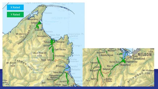
River X and Y
Rating Areas
10.6 In addition to this work, we are also progressing
the River Stopbank Recompense Annual Payment Policy with the Strategic Policy
team. All landowners who have a council stopbank on their land, but own the
land underneath the bank, received a letter explaining the proposed
policy. If a landowner is in that situation and the bank is being
well-managed, then the policy would allow compensation to the landowner of the
equivalent grazing lease.
10.7 To date we have had relatively little response.
Those that have responded are generally in agreement but ask for two options to
be considered. The first is to allow light stocking and not just sheep. The
second is to allow a fund to make contributions to fencing the banks. We have
previously had a fence contributions policy in the Land-Use team for waterway
protection, so the concept is tried and trusted within the community.
Unfortunately, we removed the fencing fund, as part of the response to a reduced
need, following the new stock fencing regulations promulgated nationally.
10.8 We see merit with both these suggestions and will
look at options as we make progress on the policy. The Policy is yet to come
back to Council for either adoption or change.
10.9 As previously mentioned, the review of the 2010
Waimea River Park Management Plan is set to begin, starting April. The work is
being led by Paul McArthur, who will assist with consultation and write
the plan. Paul is a contractor to the Reserves team and will be assisted by the broader Rivers team. The Work will be run as a
dedicated project via the Project Office, with funding coming from the Challies
Island wetland project, which is a closed account where the income is generated
by gravel fees from the Challies Island development.
10.10 Once a team leader has been appointed, we have an important
piece of work to initiate around establishing a defendable river corridor or
“fairway” that, we as staff can use as a guide to manage the river.
Fairway management includes activities in gravel management, in hard protection
(rock) and in soft management (gravel push-up, trees) on the margins. There is
a wealth of historic information relevant here but work also needs to
anticipate design capacity of the system taking into account the likes of
climate change and community expectations. We need a consistent and defendable
method to allow planning for effective river management, so that we are not
always reacting. Some of this work will also be informed by the present work
underway in the Land and Water sections of the Tasman Resource Management Plan.
10.11 Once this is established, I am expecting a River Management
Practice Guide to be developed, to allow for maintenance scheduling to maintain
that identified area, including:
· willow layering; willow and poplar pole planting;
· fairway spraying; gravel management;
· an intervention cascade for prioritising works;
· path to full stopbank and river margin access for maintenance;
· methods to determine stopbank condition assessment, and
· a policy around River Z use in small waterways and in the un-rated
areas within major river networks (not X or Y).
10.12 This River Management Practice Guide will be majorly
informed by two important pieces of work initiated last year.
10.13 Firstly, David Arseneau in the Infrastructure Planning team is working with Pattle Delamore Partners (PDP) to update and make
usable our Environmental Management Plan (EMP). The EMP is an outcome of the
Resources Consent process. Council is very fortunate to have a global consent
which allows our staff and contractors, or others under our supervision, to
work in our rivers across the district. As part of that consent, we have to
develop and operate within a EMP. PDP are taking the existing EMP and updating
and refining it for us. This will be available to use in the next couple of months.
10.14 The other important input to the River Management Practice
Guide is a piece of work, also initiated by staff, to have experienced river
engineers at Tonkin and Taylor Ltd (T&T) undertake a review of best
practice methods and prioritisation methods. This will be informed using
information from other Regional Councils to inform a method to allow our staff
to confidently prioritise work based on need and risk, rather than assumed
urgency or community pressure. While we need to be responsive to community concerns,
the price and timeliness to respond means we can miss the important while
focusing on the perceived urgent.
11.1 Alastair Clement and David Arseneau are leading a
MfE funded project looking at ‘Nature Based Solutions to flood
management’. Tasman is one of 16 projects around the country. They were
also motivated to use the government funded Envirolink scheme ahead of the
nature-based solutions work to get a nationally consistent approach to
addressing how ‘nature-based solutions’ are assessed and measured.
11.2 Essentially for Tasman our project will be
outsourced to a consultant, using the standard methods above to answer their
posed questions, run the model and provide a report that we can use in an
operational sense. We will be able to report further, once we have initiated
the project. This work is utilizing $300,000 from the Ministry over this and
next year so is a free bonus to Tasman.
11.3 Ian McComb in the Infrastructure Planning team is updating
the Activity Management Plan and the asset registers with Rivers’ and
IS&T staff to make sure the documentation and record keeping is fit for
purpose and we are doing what we say we are doing, and that we have a good
record of what we have done in our river network.
12.1 While Tasman should be
pleased with how we manage our network it is an active contest between
maintaining the extensive network as it is and in trying to improve levels of
service to the community. Following the Cyclone Grabriel event, I think it is
prudent to remind our Council and community as to what protection we actually
have from stopbanks (River X) network. For clarity this is the Waimea, the
Motueka, Brooklyn and the Riuwaka.
12.2 The table below list the
LOS as listed in the Rivers Activity Management Plan, with some additional
information added. The Level of Service of the Waimea stopbanks is currently
being re-evaluated. With work underway to update the hydraulic model of the system
to confirm this and may lead to future recommendations. The Waimea and the
Motueka Levels of Service will be updated at the conclusion of works in the
coming months.
12.3 As can be seen from the table below we do not meet
the standard best practice target of a 1% Annual Exceedance Probability (AEP)
event (also known as a 1 in 100-year return period event), with 600mm
freeboard. Additionally, we are not engaged in an active programme of
deliberate and methodical testing of the asset condition. This does not mean
that it does not happen, but has tendered to be a targeted exercise, for
example to assist the Motueka stopbank renewal project. We will be stating a
methodical and ongoing programme to assess all our built stopbanks starting
from the next year financial.
12.4 Further we were surprised at the degraded state of
the lower Brooklyn scheme and are actively working to improve that situation
now. Until we have a full asset condition assessment and a forward programme of
works, I believe that it is timely to remind the community, in a calm way, that
they are not risk free, but need to be cognisant of their own flood risk and
have plans to manage that in an event. We will be working with the Council
communications team to start this communication.
|
Stopbank Scheme
|
Level of Service standard
|
|
Waimea
|
2% AEP (1:50 year), with estimated 600mm
freeboard
|
|
Motueka
|
2% AEP (1:50 year), with 50-600mm
freeboard
|
|
Brooklyn
|
Less than 10% AEP (1:10 year)
|
|
Riuwaka
|
Less than 10% AEP (1:10 year)
|
12.5 In order to mitigate some of this risk above, and
to address the concerns raised in today’s EI Managers report to this
Committee around flood response. An important part of the new River and Coastal
Structures Team Leader role will be to work with the EI Manager, the Hydrology
Flood Response team, the Natural Hazards team and Civil Defence and Emergency
Management staff to make sure that there are Emergency Action Plans in place
for high risk areas (e.g. Peach Island) and to ensure that we can stand up a
suitable response to ensure we can both warn and manage flood events. There are
many lessons coming out the Cyclone Gabriel disaster and we do not want to be
repeating them when we get our storm.
13. Consideration of Financial or Budgetary
Implications
13.1 The
repercussions of the legal challenge over the recovery of fees for gravel
extracted in the berm land have impact on the income for the year. This
essentially limits the benefit of the income to offset rate input and to limit
the total amount of work we can undertake. It will be important for the Rivers
Account that we can recover the full fees as proposed in the Schedule of Fees
and Charges, into the future.
13.2 Work continues as per the
Annual Plan budget. After a series of floods in the region over the last few
years both the emergency fund and any reserves have been depleted. Added to
this was a price escalation in rock last year. This means that since November
2023 we have substantially throttled back planned activities especially if they
required substantial quantities of rock. From February through June 2024, we
are now not placing new rock unless it is urgent, or it makes particular sense
to maintain existing damaged asset. So only limited quantities of new rock are
being used at present. We are restacking where damage has occurred and in a
limited number of locations installing new rock (e.g. Upper Motueka) but only
to cover bases and not necessarily to do a full and final job. These areas of
work will go into next year’s schedule for review and potential
additional work once there is a sufficient budget again.
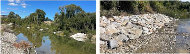
13.3 You will be aware that this is
not necessarily making everyone happy, but that saying about ‘cutting
one's garment to fit the cloth you can afford’, applies here. On a
positive note, we have had a couple of landowners make additional financial
contributions allowing additional works, or top ups to existing works, that we
did not consider urgent, to improve their levels of security. We do appreciate
this pragmatic approach by landowners and where we can, we will actively
facilitate it.
13.4 Once
adopted, and if supported the new financial year will see additional budget in
the rivers space which will be appreciated.
13.5 Lastly
as with the central government funding for the stopbank renewals in Motueka, we
will actively pursue any opportunity to bring additional external funds into
the management of our rivers. Whether it be for study, policy development,
planning, or direct operational outcomes.
Nil
Environment and
Regulatory Committee Agenda – 14 March 2024
7.5 Environmental Information Manager's report
Information Only - No Decision
Required
|
Report
To:
|
Environment
and Regulatory Committee
|
|
Meeting
Date:
|
14 March
2024
|
|
Report
Author:
|
Rob
Smith, Environmental Information Manager
|
|
Report
Authorisers:
|
Steve
Manners, Group Manager - Information, Science and Technology
|
|
Report
Number:
|
RRC24-03-3
|
1. Summary
/ Te Tuhinga Whakarāpoto
1.1 The report covers the period October
2023 through to February 2024 taking a selection of the activities of the
Environmental Information team.
2. Recommendation/s
/ Ngā Tūtohunga
That the Environment and Regulatory Committee
1. receives the Environmental Information Manager's Report RRC24-03-3.
3.1 To update the Environment and Regulatory
Committee on the activity areas of the Environmental Information team. While we
do not have an extensive capital programme, we do undertake State of the
Environment monitoring and resource management monitoring. We also undertake
surveys to enable support and advice to the wider Council and Community, and to
ensure Tasman’s compliance with national reporting requirements.
4.1 In February we farewelled Paul Sheldon
as he heads off to retirement. Paul has had an impressive career including 12
years with Tasman and 20 years at NCC, notably delivering the Regional Pest
Management Plan, the Tasman Biodiversity Strategy and spearheading the Jobs for
Nature programmes to bring in millions of dollars in Central Government funds
for conservation in the Tasman region. A well earnt gold watch!
4.2 The Kotahitanga Mo Te Taiao Alliance has approved the Strategy
Implementation Pathway Plan. As a partner to the Alliance, Tasman agrees to
actively participate in the Implementation and to work collaboratively with all
Alliance partners to restore and protect the biodiversity in the Top of the
South.
4.3 The latest Annual Impact Report has also been released and we
encourage you to have a quick read to see the extent of the activities covered
under the Alliance umbrella. https://www.nature.org/content/dam/tnc/nature/en/documents/KMTT_Annual_Impact_Report_2023.pdf
4.4 One example locally is that staff hosted a visit from the Rata
Foundation where we could show the work of the KMTT Alliance in our role. In
this case, focused on the work in Baigent reserve. Tasman had
purchased the reserve and funding secured through the Alliance was being
used to help with weed control and planting to restore the forest within. At
a future Committee meeting I will have a dedicated section to showcase our work
within the Alliance.
4.5 A new milestone has been set! Over 1000 Native Habitats Tasman (NHT)
sites survey reports have been submitted as part of the NHT project. These
reports cover nearly the full reach of our district and highlight the diverse
habitats, fauna, and flora of the Tasman district. A key part of this project
is having voluntary buy-in from landowners. This milestone reflects how
important our residents value biodiversity and the great relationships our two
contractors Mike Harding and Michael North have built with landowners in
Tasman. Two photos below of a recent batch of surveys to the Northwest Coast. A
towering northern rata that survived logging and supported countless epiphytic
plants, and a sun orchid Thelymitra sp.
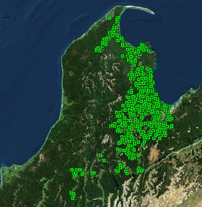

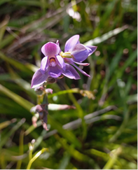
4.5 A further Ecological District report is
in production and covers Golden Bay area followed by Rotoroa. These reports are
put together using information collected through the NHT project and enables us
to get a broad overview of each Ecological District. Further information can be
found here: Land Biodiversity |
Tasman District Council (under Native Habitats Tasman
programme)
4.6 Our Biodiversity
database redesign continues with great collaboration between the biodiversity
and the IT development team. Both teams have grappled with new terminology
quickly. Lukas Jehle has shown us some innovative ways machine learning can be
harnessed to extract data from 1000’s of PDFs in the blink of an eye. The
next stage is to collaborate with Marlborough District Council and use their
database framework to suit our needs.
4.7 We are scoping
some revisions to Local Maps including a revised nesting birds layer and a
‘Potential Ecosystems’ layer to support better land management and
restoration. This work is part of the response to
the National Policy Statement for Indigenous Biodiversity.
Wetlands
4.8 Field surveys to Tapawera and the Baton Valley at the end of
February have highlighted the great work landowners are doing, with wetlands
already fenced and planted up to support native kōura/crayfish populations
“for the grandkids to look at”.
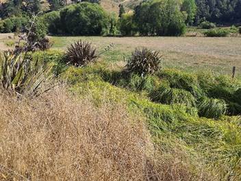
4.9 Desktop mapping of the Kaiteriteri, Moutere, and some of the Waimea
catchment have been submitted by our new wetland mapping contractor. Bright
green is non-pine dominated gullies and blue are wetland extent. These polygons
were identified rapidly by dividing the area into 500m2 grids, using LiDAR imagery, excluding land over a certain angle (15o), and supporting with our Overland Flow data and a devised
“Topographic Wetness Index”.
4.10 Next stages are to continue with this mapping while simultaneously
adding attributes from our wetlands database with the intent of seamlessly bulk
uploading these new polygons into our database once we are satisfied that they
are indeed wetlands.
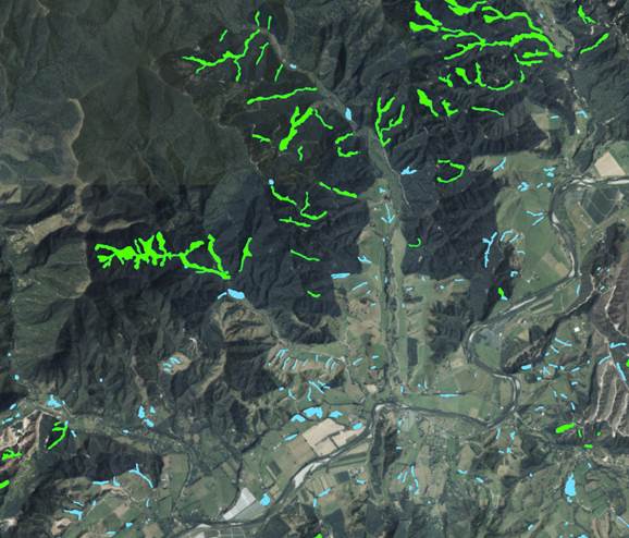
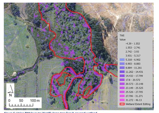
5.1 The partial review of the Tasman Nelson Regional Pest Management
Plan (RPMP) is now open for public submissions. The
review is limited to considering blue passionflower, moth plant, common and
purple pampas, water celery, Vietnamese parsley and several pest and wilding
conifer trees as new pests in the whole, or parts of, Tasman-Nelson. It also
serves to amend existing pest policies and rules around boneseed, Mediterranean
fanworm (Sabella) and feral/stray cats. The details of which place new
obligations on occupiers of land and marine craft/structures accordingly. All
submissions are being collated through the Shape Tasman page (Pest Management Plan Review | Shape Tasman).
5.2 The proposed Cat Management bylaw is also occurring in conjunction
with the RPMP review. The bylaw process is being led by the Strategy and Policy
team, and the options for this bylaw, which affects companion cats across the
district will be presented to Councilors in a workshop in April. The RPMP
review is focused on feral and stray cats in high value biodiversity sites,
specifically Abel Tasman and Nelson Lakes (alongside the existing site in
Waimea inlet) in Tasman, as well as Council reserves in Nelson.
5.3 The Marine biosecurity summer survey work, delivered through the Top
of the South Marine Biosecurity Partnership continued over the busy summer
period. Contract divers were supported by the biosecurity team and
harbormasters to dive visiting boats in the search for Mediterranean fanworm,
an eradication pest for the top of the south. Two boats, one from Lyttleton and
one from Warkworth were found with Sabella on their hulls and were directed to
be lifted and cleaned at the Nelson Marina. Both of these ports are identified
high risk ports with established populations of Sabella. One vessel had mature
individuals, and the other showed the skill of the divers in spotting very
small sabella (pictured below). This partnership has been highly
successful in coordinating surveillance and response work in the marine space.
The finds of Sabella on these two vessels highlights the importance of
continued vigilance to keep our seas free of these highly invasive pests.
5.4 The wasp biocontrol project, led by Manaaki Whenua Landcare Research
(MWLCR), has seen a successful trip to the UK to collect more of the hoverfly (Volucella
inanis) larvae, beetle (Metoecus paradoxus), and parasitoid wasp (Sphecophaga
vesparum) pupae, after a failed raring attempt last year. All three of
these species must adjust to New Zealand's seasons and then successfully breed
before being released. It is hoped that there will be the opportunity to
release at least one of these biocontrol’s in the Tasman region this
year.
5.5 Old man’s beard sawflies, sourced from MWLCR, were released at
two locations in Tasman in February. The larvae stage of the fly does all the
damage by chewing their way through leaves, which ultimately impacts on the
vine’s vitality and vigor. These flies were already approved for release
by the EPA in 1996 and field releases began in 1998. Unfortunately, there were
issues with rearing the flies and a genetic bottleneck problem that resulted in
the flies failing to establish throughout the country, except for a small
residual population found in 2015 at a release site near the Waimea River. New
stocks were sourced from Serbia, and these have proved to be a much fitter
population of flies. We will be monitoring these two release sites, one at
Trass Valley, the other at a site adjacent to the Motueka River, with great
interest over the coming years. Vespex wasp bait was laid to reduce larvae
predation by wasps.


6. Central Government supported work
Wilding Conifer Control – Mount Richmond
Management Unit
6.1 A
lot of work has been undertaken recently tackling large scale infestations in
the Wairoa Gorge and around the Gordons range in the southwestern side of the
Management Unit. Ground crews have also been working up the Motueka River
in the Sandy Creek area tackling Douglas Fir both in and under the
canopy. The next few months will see further work in and around the
Gordons area, particularly above Inwoods lookout and the faces below Gordons
Knob (see images below for levels of infestation). This year will benefit from
additional funding from the National Wilding Conifer Control Programme, with
$125,000 going towards the control efforts on the Gordons range where Pinus
contorta and Douglas Fir are spreading above the native bush
line. Work in the ultramafic areas continues with control in and around
Porters flats.
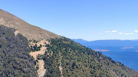
Waimea Inlet Enhancement Project
6.2 Salt
Marsh Restoration Trials – Salt Ecology have completed their assessments
of the remaining areas of the Waimea Inlet that present the best options for
salt marsh restoration. The ‘best’ site in their ranking is
the Rough Island Embayment area (see image below). This is in between the
Equestrian Park and Tic Toc Road. Planning is underway to assess options for
allowing further tidal inundation into this area through increasing the culvert
capacity. This will create great conditions for further salt marsh
vegetation.
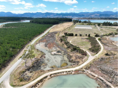
6.3 Pest
plant control is well underway in both Nelson and Tasman parts if the Waimea
Inlet. Control of class 2 species including Tamarisk, Juncus gerardii, Boneseed
and Carex divisa all well underway. A suspected, new to New Zealand, Juncus
species was found and reported to the Ministry of Primary Industries (MPI) at
Sandeman Reserve. This has seen been surveyed and controlled by our
contractor.
Waimea Inlet 1 billion Trees (Phase 2)
6.4 Soil
moisture levels are presenting some issues with our planting in the lower
Waimea River area. Hopefully the showers we have started getting continue, as
some sites have seen wilting of some tree species. The project is on track
to plant over 100,000 native plants over the 5-year duration.
Sites for
next winter:
· Neimann
Creek – further wetland and lowland forest planting around a newly
constructed wetland
· Moturoa/Rabbit
Island – continuing along the traverse between Moturoa and Rough
Island.
· TET
Battle for the Banded Rail plantings (3000 plants across a number of Tasman
Reserves)
· Rough
Island – targeting some of the tougher to establish areas with drought
tolerant species.
· Waimea
Delta – a final area of terrestrial planting
· Airport
Peninsula with Nelson City Council – aiming at restoring dune
forest.
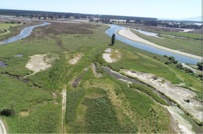
The Tasman Wetlands project:
6.5 Achievements
over the last few months include the Wharariki wetland. Earthworks to plug
drains and re-wet areas in the “Bull Paddock” near Cape Farewell
Road is now complete. Earthworks on the final stage (Stage 3) at the
Reilly stream rehabilitation and wetland construction was completed in February
2024. As can be seen to the left of the photo below, prior to this
rehabilitation, the stream was very straight (the whole stream was like that).
Various tile/novaflow drains enter this reach from the surrounding farmland and
are now treated in the valley-floor wetlands. This has been a rewarding project
for staff to work on and we have had good support from the landowner. The inset
photo shows how Stage 2 (1b) looks after two years. The “cover” and
protection provided by the over-hanging Pūrei (Carex secta tussock), and
in-stream logs/branches is now provided excellent habitat for fish, koura and
other species. This work has stood up well to several floods, including the
large August 2022 event.
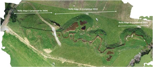


6.6 The
overall Jobs for Nature Tasman Wetlands Project has delivered 1549 hours of
weed control and general wetland restoration work completed in the last 3
months of 2023. 198ha of weed control now completed by the project, along with
28,170 stems planted and 146 rangatahi and tamariki engaged in wetland learning
opportunities.
The Job for Nature Fish (J4N) Passage Project
6.7 Good
progress continues to be made with a total of over 4,100 in-stream structures
having now been assessed and over 700 remediated. We may even reach the 5-year
target for assessments in only three years. As per our long-term average, about
25% of all in-stream structures are found to be barriers to fish migration. We
have approximately 130 fish passage barriers that require considerably more
funding than the J4N project can provide and are ‘parked’ and
awaiting prioritisation and funding. Note that the J4N project was largely
about providing jobs and there was only limited funding for materials. These
parked projects may be reviewed as part of the Catchment Management funded work
in the future.
6.8 The
J4N Fish Passage Project is also providing very valuable information about the
efficacy of our standard remediation methods which is very helpful for the
wider New Zealand freshwater fisheries community. A report on this has been
peer-reviewed by Cawthron and should be complete soon. We now have several
months’ worth of daily monitoring data of fish passing through in-stream
structures, both before and after remediation. This clearly shows that in the
majority of settings, and majority of fish species, we are
successful.
7.1 The hazards team and consultants e2 Environmental have completed
work on the flood model of the Moutere valley. The completed report and
modelling files were received by Council in November 2023. The modelling
includes scenarios for a 2% AEP event (a ‘one-in-50-year’ event), a
1% AEP event (a ‘one-in-100-year’ event), and a 0.4% AEP event (a
‘one-in-250-year’ event). The 0.4% AEP event was included to
represent a ‘maximum credible event’, to provide context for the
scale of flooding that could occur in an extreme storm event such as Cyclone
Gabriel. All events include the projected effects of climate change out to the
year 2100. The model shows that essentially the entire valley floor floodplain
is inundated during flood events (see figures below). The model therefore
provides Council with critical information for the setting of ground and floor
levels to ensure that any future development within the valley is resilient to
inundation hazard.
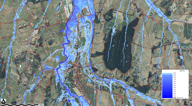 Screenshot of the new Moutere
valley flood model for a 2% AEP event for the area around Upper Moutere.
Screenshot of the new Moutere
valley flood model for a 2% AEP event for the area around Upper Moutere.
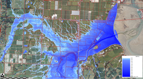 Screenshot of the new Moutere
valley flood model for a 2% AEP event for the area around the mouth of the
Moutere River.
Screenshot of the new Moutere
valley flood model for a 2% AEP event for the area around the mouth of the
Moutere River.
7.2 The hazards team continues to work with
e2 Environmental on the update of the Tākaka flood model. Most recently
Glenn Stevens has been working with e2 investigating flows to flush the
Motupipi River during flood events in the Tākaka River that spill over in
the vicinity of Bridge’s Hollow.
7.3 A project has been initiated between the hazards team in conjunction
with the rivers team and hydrology to understand flood flows at the mouth of
the Waimea River. This was prompted by the photo below from the August 2022
flood event showing overtopping of stopbanks at the mouth of the river. The
project is currently at the scoping stage.
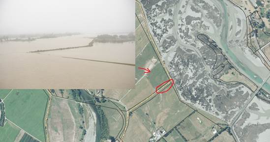
Map showing
the stopbank on the true-right bank at the mouth of the Waimea River, with area
circled in red being overtopped in the August 2022 flood event. The inset photo
shows the overtopping—photo taken by Council staff on the morning of 20
August 2022. The red arrow shows the direction of view of the inset photo.
7.4 The hazards team continues its efforts
to ensure that new developments across the District are resilient to natural
hazards and the effects of climate change including sea-level rise. This
remains a challenging task as there are many areas across Tasman that are
susceptible to inundation from rivers or the ocean during storm events.

7.5
Dr Alastair Clement attended the 20th conference of the Australian
and New Zealand Geomorphology Group (ANZGG), held in Gisborne from 12-18
February 2024. Alastair presented a poster on the bank erosion that occurred in
the lower Wai-iti River during the May 2023 flood event. The conclusions of
this research were that the primary driver of the bank erosion that occurred
during the May 2023 flood was due to the extended duration of the flood event
and not the peak flood flow conditions.
7.6 Bryan Scoles has been undertaking analysis of shoreline changes
across the District, building on recent work by the University of Auckland.
Bryan has quantified shoreline change rates dating back to 1843 in some
locations. This analysis has shown there has varying levels of erosion and
accretion along our coast. Since the year 2000 there has been a trend of
increased erosion along the majority of the District’s coastline. An
interesting example, Moturoa/Rabbit Island, had significant accretion at its
western end between 1843 and 2000, whereas for the same period at the eastern
end there was significant erosion, while the central section was relatively
stable. Since 2000 the eastern end of Moturoa Rabbit Island has seen accretion
and part of the western end has seen erosion, while the central section has
seen significant erosion.
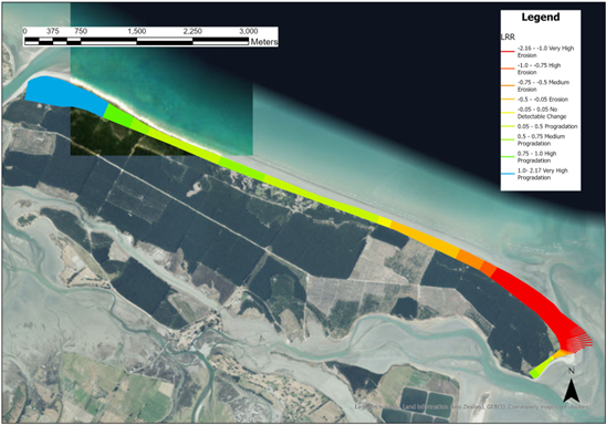
Digital
shoreline analysis of Rabbit Island with shorelines dating from 1843-2003
showing progradation at the west end and erosion at the eastern end.
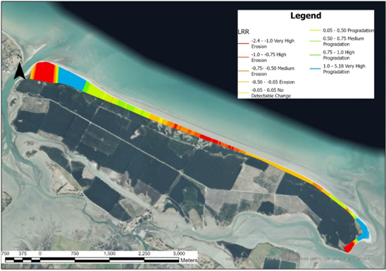
Digital
shoreline analysis of Rabbit Island with shorelines from 2003-2021 showing
erosion at the west end and central part of the Island with progradation at the
eastern end.
7.7 Staff have been working closely with the Rivers team to begin to
develop a dataset to better understand relationships between extracted volumes
of gravel and the truck weights returned by contactors. This will involve a
number of pre- and post-gravel extraction surveys of river beaches where
extractions take place, and comparison of these survey volumes with the returns
from contractors. This project is expected to take up to two years to complete
as a large number of individual surveys of different extractions will be needed
to build up a reliable dataset. We will also start to look at
bulking volumes (solid to lose measure) used in gravel volume estimates as part
of this work. At the end of the day, we want to make sure our own and the
contractors estimate process is equivalent and that we have a complete picture
of the real volume of gravel removed from any extraction site.
7.8 Staff have also been involved with surveying sand volumes at Torrent
Bay, Awaroa Inlet and more recently the Kaiteriteri Beach. This latter job is
to monitor the behavior of the beach and develop a record to understand the
long-term sustainability of the sand relocation works undertaken annually by
the Kaiteriteri Domain Board.
8.1 Soil quality monitoring undertaken as part of Tasman’s State
of the Environment (SOE) programme was completed last calendar year with 37
sites. These comprise different soil types and land uses, across the district.
We are testing for soil biological, chemical and physical attributes. The
results will be compared against the target values as well as results of
previous monitoring programmes to detect any trends in overall soil health.
Frequency of re-sampling depends on the intensity of the land uses, but it is
often every 3–5 years. This information is available to the
landowners and contributes to our broader understanding of Tasman’s
soils.
8.2 Ardi Ass has been assisting Manaaki Whenua Landcare Research with
soil surveying of Moutere Valley for the S-map project. S-map is a digital soil
map for New Zealand, providing accurate soil information to support sustainable
management of our soil resource. S-map shows basic soil
property data such as depth, stoniness, and clay content, as well as more
complex data including water holding capacity and nitrogen leaching risk. This work is funded by both MPI and Tasman. This is the
fourth of a five-year project to rapidly advance the national scale of the
information set, but also has a great benefit to Tasman’s landowners and
our consenting team. This data is directly relevant to the National Policy
Statement for Highly Productive Soils. All the information is available online.
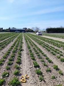
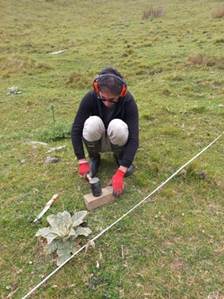
Taking soil samples along a
50m transect at a market gardening (left) and a pasture (right) site – Oct 2023.
9. Hazardous
Activities and Industries List (HAIL)
Changes to HAIL guidance
9.1 Following
changes to national HAIL guidance in March 2023, any property which has had
horticultural use (orchard, vineyard, market gardens, glasshouses) is
considered a HAIL site. This is because new guidance states orchards which may
have been sprayed with pesticides including copper are now considered a HAIL
activity. This is causing some concern for our developers and landowners,
but we are not treating this differently to other areas of the country. To date
we have taken a relatively pragmatic approach, but this is the status now. The
revised HAIL guidance can be found on the following link: Hazardous Activities and
Industries List guidance: Identifying HAIL land | Ministry for the Environment
9.2 The
implication of the guidance is that more sites in Tasman have potential for
contamination than are currently on the register. Staff are working with
consents team to identify sites during the consenting process. The
current mapped orchard layer and HAIL register is not complete, and properties
are added to the register following enquiries and on review of site
investigation reports.
9.3 There
are also approximately 200 error sites on the HAIL register which we are
reviewing. Many of these properties were mapped as orchard and subsequently
changed to error when shown to be stonefruit and not pip fruit, or in orchard
after the mid-1970s. However, we need to address this given recent HAIL
guidance suggests that all orchards should be included on the register, even if
they have only ever used copper. A review of the existing mapped orchard
areas which have previously been on the register as error sites will now revert
back to category V (verified) and letters to owners will be sent.
Potential Lead Paint Contamination of Dwellings, Buildings
& Land
9.4 In
order to raise awareness of the potential for metal contamination from lead
paint, a new statement has been added to all Land information memorandums (LIM)
and consents regarding potential for metal contamination of soils around older
homes. The following statement is now included on all LIMs and consents:
Lead is a highly toxic substance that was a key ingredient in household
paint. Any building or dwelling built before or during the 1960’s is
likely to have used lead-based paint at some time. Soil surrounding these
buildings has potential to be contaminated by heavy metals contained in the
paint. Landowners are responsible for ensuring the safe management of lead
paint removal for protecting human health and the environment.
Fruitgrowers Chemical Company, Mapua site
9.5 Annual
groundwater sampling of selected monitoring bores at the ex- Fruitgrowers
Chemical Company site at Mapua was undertaken in December 2023. Results
for pesticide residues show an ongoing steady trend (not positive or negative),
following the remediation and clean up completed between 2004- 2007.
Murchison Air Quality Monitoring Winter 2023
10.1 Through
the 2021 Long Term Plan, budget was allocated for winter-time temporary PM2.5
monitoring of smaller towns in the District as a ‘surveillance’
work programme. PM2.5 was monitored in Brightwater and Wakefield over
winter 2022 (and reported in the 2022 Annual Air Quality Report), and this
presents the results of the monitoring from Murchison in the 2023
winter. The full report will be available on the website.
Between 25 May and 14 September 2023, Mote Ltd monitored PM2.5 in Murchison
using a network of three ‘dustmote’ sensors (Met One ES642
near-forward nephelometers, suitable for research purposes) and a
meteorological monitoring station (see the map below).

10.2 Analysis
of the Murchison monitoring results conclude that while emissions from domestic
home heating did result in an increase in PM2.5 concentrations during winter,
peak concentrations at all three Murchison sites remained below the 2020
Ministry for the Environment’s proposed 24-hour average National
Environmental Standard for PM2.5 of 25 µg/m3. The highest peak
24-hour average PM2.5 concentration of 18.4 µg/m3 was recorded at
Murchison South, while the Murchison Central Site recorded the highest PM2.5
average for the monitoring period of 9 µg/m3. The Murchison North site
exhibited the lowest overall concentrations of PM2.5 during the monitoring
period. In 2021 the World Health Organisation (WHO) published updated
‘global air quality guidelines’ and of relevance to this study is
the recommended 24-hour PM2.5 guideline of 15 µg/m3 which allows for up
to 3 exceedances per year. Based on the 2023 monitoring data, only one site -
Murchison Central - would not comply with the WHO 24-hour PM2.5 guideline (with
5 exceedances – so with 2 breaches of the guideline in winter
2023).
Motueka Air Quality Monitoring Winter 2023
10.3 During
the winter 2023 monitoring period, a dustmote was also co-located with a
Council monitoring instrument (Partisol) at Ledger Goodman Park, Motueka. Both
instruments monitored PM2.5, with the dustmote monitoring continuously, and the
Partisol sampling ‘1 day in 3’ from June onwards. The figure
below illustrates the results from the dustmote monitoring – with 19 days
of breaches (so 21 days above the standard) of the WHO 24-hour PM2.5 guideline
of 15 µg/m3 (grey line) during the monitoring period. There were no
exceedances of the 2020 Ministry for the Environment’s proposed 24-hour
average National Environmental Standard for PM2.5 of 25 µg/m3 (orange
line). This is consistent with the results of the Council’s Partisol monitor,
for the days that it was sampling. The data for winter 2023 is consistent with
the use of wood for home heating. The relevance of using the two machines
is that the Partisol is an approved method, but each filter is quite expensive
to buy and process. To cover the full daily period, we use the survey tool
(Mote) calibrated to the approved tool, to fill in the gaps.
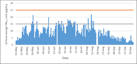
Motueka 24-hour average
PM2.5 concentration for Dustmote
10.4 As noted in the 2023 Air Quality Report, the data
collected from Motueka in recent winters indicates that PM10 is not likely to
breach the current Air Quality NES standard. Given budget constraints,
Council staff are considering stopping winter-time temporary monitoring of
PM10/2.5 in Motueka until such time that a new standard for PM2.5 is
introduced. Council staff await further advice from the Ministry for the
Environment on the expected future requirements to monitor and manage
PM2.5. In the meantime, our efforts will be on non-regulatory programmes
such as education and best practice advice to support our Tasman communities to
reduce smoke pollution.
11. Environmental Monitoring
11.1 A network of 26 continuous flow monitoring sites, 5
water level, 2 sea level, 3 surface water conductivity, 7 surface water
temperature, 1 surface water turbidity, 57 groundwater level, 44 rainfall, and
3 weather stations are maintained. This long-term data record at our monitoring
sites has a significant value in informing trend and frequency analysis.
11.2 Flood events in recent years, including August 2022,
produced significant erosion at several flood warning sites. Repair work
occurred during recent lower river flows, assisted by the Rivers Team and
Taylors Contracting. Site maintenance is key to data reliability and was
carried out at Motueka River at Woodmans Bend, Wai-iti River at Belgrove and
Wai-iti River at Livingstone (below).
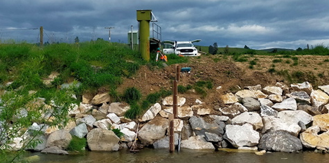
11.3 Unfortunately,
two recently installed groundwater monitoring sites to support water resource
management in the lower Waimea catchment were vandalised. One of these sites
was vandalised twice. This is expensive equipment to replace but of
relatively little value to anyone, unless they were monitoring water level. The
police are aware of other thefts occurring in the area at a similar time.
11.4 Low
flow gauging data is being collected at spot sites around the region to expand
upon the Environmental Monitoring Network database. Priority this summer is the
Waimea River catchment to support work relating to the Waimea Community Dam,
the Upper Motueka catchment to support water plan management, the Aorere
catchment to support water plan development and sites that support the Dry
Weather Task Force.
Harley Trafford (EMO
Trainee) who replaced Chris Strang (Senior EMO) in mid-January flow gauging the
Brown River, Upper Aorere Valley 22 February 2024
11.5 A river
health study of the Upper Motueka River catchment is in its fifth and final
year contributing data to a review of the Upper Motueka water management
plan. Sensors are deployed across the catchment to record temperature
and dissolved oxygen trends. The interaction between stream flow and
groundwater is being assessed by repeated runs of flow gauging’s at
sixteen locations down the catchment. This is an intensive project, and we will
be pleased to be able to redirect staff onto other work in future summers.
11.6 The
Recreational Water Quality and Toxic Algae Monitoring Programme was run by the
EM team and the summer students. This year sampled a greater range of popular
and ‘at risk’ swimming sites this year. Additional commentary is in
the River and Lake section further on in the report.
11.7 Toxic algae
reached warning levels in the Wai-iti River just prior to Christmas and the
public were notified and signs put up. It has since dropped well below alert
levels and signs were removed in early February, making the alert period
shorter than previous year’s.
11.8 Summer data
collection is resource intensive and prioritising workload is important. Summer
interns are a valuable additional resource for routine work. The
Council’s internship programme also offers a valuable steppingstone into
the industry, and this year Rachel Curtis has used her Tasman experience to
gain employment with NCC.
11.9 Monitoring
work for the Waimea Community Dam continues, including operating a flow site
immediately downstream of the dam, a downstream turbidity site, a weather
station and water level station at the reservoir. The dam’s completion is
a satisfying result to data collection the team has been involved with before
and during construction.
11.10 Jon McCallum was
redirected from the team for 3 months to analyse River Water Quality Programme
data for the work to support the National Policy Statement for Freshwater
management (NPS-FW) attributes work, along with Dr Annette Belcher, the work
contributes to support the development of a Draft Freshwater and Land Plan
Change. Some priority database work was delayed, some monitoring cancelled
(e.g. Summer Sonde Deployment programme) and some work backfilled by the team
and a consultant. This reporting will provide the community greater access to
data, and includes summarised bands of state, A (very good) through to E
(poor), an example below. We will report back in the future with more detail of
this work.
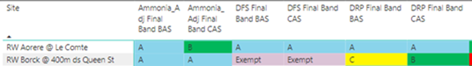
12.1 Database
management: The Environmental data team continues to work to quality assure the
mean streams of data into council databases. For many data sources we apply the
National Monitoring Standards (NEMS) to give a quality code to this data to
determine how well it describes the parameter measured. Application of quality
assurance is important to enable consistency of data through datasets that in
some cases extend back continuously to the 1950’s. The next challenge in
this area is to apply the recently updated NEMS for Particulate Matter (Air
Quality). This will involve collating information about how we collect the data
and applying it to new data as it is collected and then looking at how we can
retrospectively implement it to cover data collected since the early
2000s.
12.2 Data
Provision: Maintaining data quality on incoming real time data is highly
important during periods of low flow in the rivers, as we are currently
experiencing. Working closely with the Monitoring team we ensure the
calibration checks (flow gauging’s) are carried out at key monitoring
sites in a timely fashion so that we are able to maintain the flow
relationships to accurately measure the river flow. Monique Harvey has been
compiling this information into Power BI reports that can be utilised through
the Dry Weather Task Force to inform decisions around water rationing outcomes.
Environmental
Monitoring Data Summary.
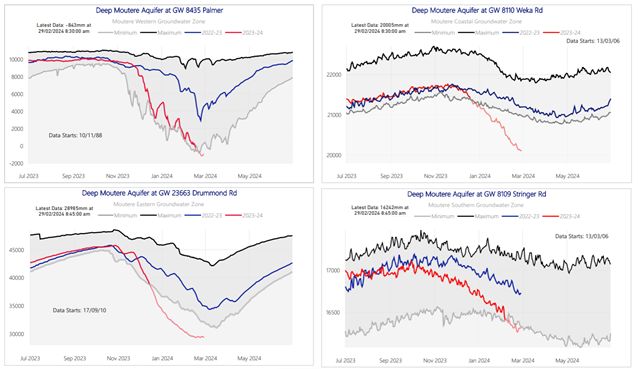 Excerpt from Data Summary Report showing
status of monitoring on the deep Moutere aquifer which has recorded historic
lows this summer.
Excerpt from Data Summary Report showing
status of monitoring on the deep Moutere aquifer which has recorded historic
lows this summer.
12.3 Wairoa Un-Modified Flow Triggers: In
conjunction with Martin Doyle (Principal Hydrologist) the team has designed
outputs that feed in flows to the Water Consent Monitoring (WCM) system
(sometimes call the water metering database) to allow monitoring of trigger
conditions for river flows when the Waimea Dam is operational. A key part of
this is determining what the river flow would be if there was no dam in place.
This is known as the un-modified flow and is derived by utilizing data from
neighbouring natural river catchments to predict what the Lee catchment flow
would be if it was in a natural state. As river flows recede, we continue to
watch how this derived relationship is performing and optimize the code that
configures this output. Once the dam is commissioned the Un-Modified flow
parameter will be published on the Council website as required by the dam
resource consent.
12.4 Database processes Migration: The IT team
as part of the Digital Innovation Project (DIP) have been steadily moving many
computer processes to the Azure cloud environment. The data team has been
working with IT where our processes are impacted. The move has led to
improvements in the functioning and robustness of these processes. However,
many of our database systems are built on legacy software platforms which
cannot function in a modern cloud computer environment. Therefore, work is
underway to look at how we can migrate this to a data centre hosted environment
instead. With data stores located off-site we reduce risk associated with
having all functions located in the Council Office. Although this introduces
reliance on functioning communication systems, which in an emergency situation
(flooding) are absolutely essential. So, whilst resilient and multiple
redundant communication pathways are investigated and implemented the IT team
have improved our computer resource onsite at Queen Street to ensure continued
optimum use for the immediate future.
12.5 Legacy Software: The limitations of some
of our legacy software is noted above. This is not uncommon across most
councils in New Zealand. We have been partaking in a national program lead by
the Environmental Data, Special Interest Group to investigate and implement a
national Environmental Data Monitoring System (EDMS) that will work in
conjunction with legacy software to bring them into a modern computing
environment and allow transition for systems at varying states of their life
cycles. We have been involved in assessing vendors for the
‘functional’ aspects of this system, i.e. how it will work with the
data, as opposed to how it is built as a computer system. This is now at the
final vendor selection stage, and we expect this to be concluded in the coming
weeks.
12.6 Website: Our legacy software also drives
our data outputs to the website, and this has been problematic in the recent
past, with several failures during flood events due to overloading as large
numbers of people attempt to view the website graphs. We have made incremental
changes in some of the building blocks that run these processes but are still
not 100% confident that they will perform under high loads. Therefore, we are
currently in vendor selection stage for a partial website revamp to principally
address the load management situation. This will focus on just the real-time
river and rainfall data provision for use in emergency events. Vendors should
be selected shortly with a timeline to have a new system in place by the end of
June. In the meantime, PowerBI reports have been utilized for some website
outputs where critical timeliness is not an issue, mainly this is around lab
provided data in water quality programs and groundwater level monitoring.
12.7 Telemetered Water Meters: The number
of telemetered meters has grown for this season, now with a total of 118 water
meters reporting directly to our hydrology database, via third party service
providers. The meters cover 104 water take consents (some consents
require multiple meters to report their use). With the Waimea Community
Dam close to completion, the unaffiliated takes that are over 2000m3/s
(total of 11 out of 75 unaffiliated consents) that are currently using water
are required to telemeter their meters. Six of them are now online
reporting to us so far. For reference, the number of telemetered meters at 118
is around 10% of all the water meters in the region. So, most information is
collated on a weekly basis.
12.8 Staffing: In the new year we welcomed
Stephen D’Andrea to the team as an environmental data scientist, so we
are now back at our full complement of staff. Stephen comes to us with
experience as a statistician working for a municipal authority in California.
He will be building on ongoing work to provide new uses for much of the data we
collect and hold, including how to visualize and report this data.
13.1 One year on from Cyclone Gabrielle, very
close scrutiny is being placed on the Councils who were in its path, in
particular their ability to provide timely accurate data to the public who were
affected. It’s timely to consider Tasman’s ability to provide a
good flood warning service.
13.2 In the wider picture, prior to Gabriel,
efforts have been made to improve flood forecasting ability across New Zealand,
with vastly different abilities and level of preparedness seen in the various
Councils. Martin Doyle from Tasman has been very active in this process,
organising the first flood warning workshop held in New Zealand and
co-organising two more. An ad-hoc steering group was formed several years ago
to lift the ability of the Councils with few resources, and this has just been
recognised as a formal working group under the Regional Council Te Uri Kahika
structure. This gives the group the mandate to suggest and effect change.
13.3 Another key outcome of the group was to
commission a national survey of the flood manuals held by the 16 Councils with
regional functions. From this it was clear Tasman has good flood warning
systems in place for a small Council, but needed to improve documentation, and
is considered deficient in its ability to manage an extreme flood when it
arrives. This is no reflection on the CDEM team, but rather the interim
step between warnings and post flood welfare. As an observation, the Councils
that do have good systems to manage floods typically have a strong river
engineering programme. Tasman outsourced this work around 2000 and has not
recovered relative to most other Councils with Regional functions. We are in
the process of building this capability again via the appointment of a Team Leader to lead the Rivers team and participate in
the management of flood events in the future.
13.4 Tasman has also been very active in
promoting a good working relationship with outside agencies such as MetService,
and we represented the flood warning community during the recent review of
weather forecasting in New Zealand. Our Council is also active in promoting
data systems to improve the flow of information both nationally and at a local
level. One weakness remains in this area, in that our website is not
particularly capable of withstanding high loads on the river and rainfall pages
during major floods, although it’s pleasing to note that a contract will
shortly be let to complete this work. In addition, our ability to provide
warnings to individuals (as opposed to them seeking information) remains weak.
On the plus side, we remain fortunate to have 4 experienced people on the flood
warning team to service both Tasman and Nelson. Some Councils do not have any
experienced people working in this area (Tasman provides the flood warning
function for NCC). We also have considerable knowledge in the hazards team, and
all staff motivated to collect ongoing data during floods.
13.5 Work is being done at present on a
complete review and rewrite of our flood manual, including a new design of a
‘prompter’ page for each flow site as shown below, the ongoing
re-calibration of our flood prediction models (in particular incorporating the
Waimea dam into the Waimea model), and fixing some niggling communications
issues we have to enable reliable communication to our new marine radar
(we’ll report on the radar in July).
13.6 In summary, if we take an honest
assessment of our ability to respond to floods, we score well for a small
Council and better than some large Councils for our ability to provide flood
warnings, but we are weak in the ability to respond to a very large flood that
would affect a densely populated area. Part of the work with the EI team and
across Council is to lift this aspect of our service as well as strengthening
the systems that support staff and protect our community.
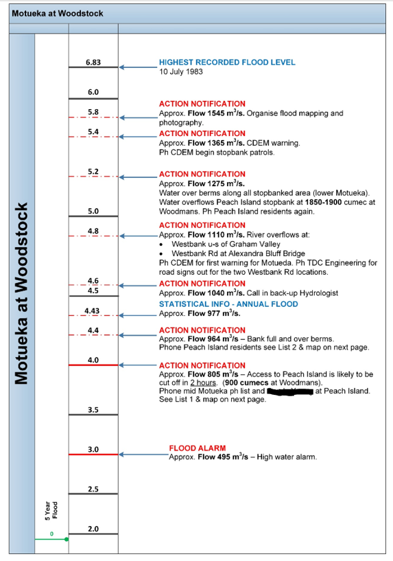
14. Catchment Enhancement Programme
14.1 Emma Woods left the position ‘Catchment Enhancement
Officer’ on 16 February after two years with us. Applications for this
position closed on 29 February. It is pleasing to note that while we have
difficulty recruiting in some areas of council, in the water and catchment
space at present there are good candidates wanting to work for Tasman.
14.2 Some of the major projects covered this year include. The
Eastern’s wetland with earthworks and spillways now been completed for a
new wetland inland from Easton Loop Road off SH60 along the Moutere Inlet. This
is a particularly large wetland (almost 1ha) and was designed with the
particular objectives of improving biodiversity (including marsh birds and
fish) and filtering of potential contaminants (such as fine sediment) to
improve the health of the Moutere Inlet. In the 1980’s a straight channel
was cut through the valley floor, draining the original wetland and shortening
the waterway. The landowner has invested a
lot in the wetland with earthworks and plants. Planting will happen this
winter.
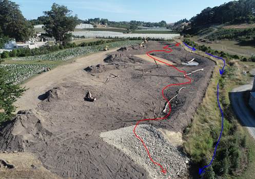
14.3 The earthworks and spillways for the Robilliard wetland in the
catchments of the eastern Motupipi Estuary are complete. A limited amount of
planting will occur this winter. It is hoped that external funding will be
available for planting the remainder.
14.4 Fish-friendly tidal flapgates. It is pleasing to see much higher
numbers of inanga upstream of the tidal flapgate at Pearl Creek since a device
was installed to increase the opening times. We are hoping for a much higher
level of inanga spawning over the coming months.
14.5 Not all the advice leads to actions immediately some is for the
landowners to take away and manage issues themselves, for example spending time
with landowners discussing the streams in Tui Community and dairy farm Wainui
Bay area around managing sand accumulation and sea level rise, along with
re-meandering some straightened sections. With such diverse and abundant fish
communities just upstream of these modified streams, it is highly likely that
with enhancing these streams will return aquatic biodiversity to the lower
reaches also.
15. Freshwater
Farm Plan Programme
15.1 Without any detailed direction from the new government as yet, we
have been asked to apply a 'light touch approach’ to implementing the
Freshwater Farm Plan Program (FWFP). The consensus is that the Farm Plan
Regulations will stay, albeit with a few possible amendments. This also means
that the core principles of the Tasman Freshwater Farm Plan Program should
remain, namely:
· A supportive common-sense approach between landowners and Tasman
staff
· Working closely with industry to ensure industry assurance systems
and Tasman expectations align
· Making easy to interpret information and tools available to
landowners to empower them to write their own plans
· Set and communicate clear expectations on the contents of FWFP to
both landowners and certifiers
· Work closely with policy to ensure that FWFP are integrated into the
new Freshwater Plan to allow them to be a delivery pathway for permitted and
controlled activities.
15.2 In terms of delivery timelines, we are still
working towards having Tasman ‘switched on’ during 2025. We have
not heard from MfE about our specific timelines that we need to work towards
since supplying the relevant information at the start of November 2023. This means that we are continuing with our work plan as shown in the
19th October report.
Following are the key elements of that
work program and our progress so far:
15.3 Policy: Through Land and Water Science we have
commissioned new land use maps for Tasman. These maps are at property boundary
scale, and we have further refined land use in blocks less than 5 ha and less
than 20 ha. This is so that we can get a good handle on properties needing a
FWFP and their respective land use. For blocks less than 20 ha it will also
highlight any areas where there may be potential for cumulative effect of land
uses outside of the FWFP regulations. As a next step, we will be sharing the
map with other council departments to cast an eye over accuracy and point out
any errors that may have occurred during the modelling. We are meeting weekly with the Policy
team to discuss the integration of FWFP into the developing Freshwater Plan
rule framework.
Screenshot of Land Use
Map, Waimea Plains
15.4 Actions Plans: First draft Action Plans have been contracted to be developed for
the Waimea and Tākaka catchments, the due date is end of March 2024. After
this and in conjunction with the policy team these will be further developed
with input from Manawhenua and external stakeholders.
15.5 Freshwater management unit (FMU) information: We are currently working on our first
draft and visuals to communicate catchment context to landowners in a format
that can easily be integrated into FWFP. We will be testing the language and
layout with landowner and industry groups sometime after March. We are
working alongside our IT team to be able to have a platform through which we
can publicise the mapping information needed for FWFPs. The due date for this
is August 2024.
15.6 External engagement: We have had many one-on-one meetings
with landowners and industry professionals to establish focus groups to test
our communication materials as well as some of the policy integration ideas.
Meetings with these groups will kick off sometime after March.
Aorere/Tākaka Freshwater Management Units (FMUs)
15.7 Te Puna Waiora o Te Waikoropupū Springs and
Wharepapa Arthur Marble Aquifer Water Conservation Order (WCO) came into effect
on 19 October 2023. The WCO applies to the recharge area for the Wharepapa
Arthur Marble Aquifer (WAMA). This is the area of catchment where land and
water use has the potential to influence the quantity and quality of water
flowing into the groundwater that feeds the Springs. Hence, the WCO potentially
affects everyone (not just farmers) living and working in the WAMARA who use
water, or creates a discharge that could affect nitrate, phosphorus, dissolved
oxygen, or clarity in the aquifer or at the Springs.
15.8 The WCO sets restrictions on council’s
functions regarding management of water quality and flows at the springs.
Specifically, the WCO: Sets
water quality limits for nitrate, phosphorus, dissolved oxygen, and water
clarity to be met at the Springs.
·
Sets a limit for nitrate at the Main Spring to
be met by 2038.
·
Sets a maximum water allocation limit for the
recharge area (WAMARA).
·
Sets a minimum water flow to be protected at the
Main Spring.
15.9 A designated page is on Councils
website for everything and anything to do with the WCO is now live. This
page will provide:
·
Information about the WCO; what it is setting
out to do and who that affects.
·
Water monitoring data and results reported
against limits.
·
Progress on Plan Changes that will support the
intent of the WCO.
15.10 Since its gazettal, we have completed land use mapping, and
this data is being used to identify land use types and models for their
Nitrogen footprint. A biophysical risk layer is in the works to provide land
users with a view of their vulnerabilities to Nitrate leaching and the type of
tools that will be effective in reducing Nitrate.
15.11 We are working with Farmers of the Arthur Marble Aquifer
(FAMA) to develop implementation actions and solutions. This work will feed
into the Freshwater Farm Plan Program (FWFP) to be rolled out in 2025. The Farm
Plans will serve as a key tool in prioritising the actions to reduce nitrate
leaching in the Waikoropupū Arthur Marble Aquifer Recharge Area
(WAMARA).
15.12 We are also working in partnership with
manawhenua iwi (Ngāti Tama ki Te Tauihu, Te Ātiawa, and Ngāti
Rarua) who will prepare a cultural health monitoring report to inform
preparation of changes to the Tasman Regional Policy Statement and Tasman
Regional Management Plan and assessments of water and discharge permits in the
WAMARA.
Motueka/Moutere/Abel Tasman FMUs
15.13 The Motueka, Moutere and Able Tasman
FMU’s are very active with quite a few resident community groups. With
Motueka, the home catchment of Tasman Bay Guardians and the Tasman Landcare
Trust coordinator, there are plenty of opportunities for community engagement
around FWFP’s. Examples of engagement include:
·
October - Motueka Catchment Collective Survey
Response meetings held in Tapawera, Ngatimoti and Motueka Community Library
– 62 attendee's total.
·
November: Hops Workshop held at Ngatimoti
Community Hall – 30 plus attendees.
·
December: Restore the Moutere Catchment Group,
Moutere Community Hall – 30 attendees.
15.14 To ensure these very
active groups and NGO’s stay connected and informed about FWFP, every two
months a Motueka Catchment Associate Network meeting is held with
representatives from catchment group leaders, MPI, Landcare Trust, and Tasman
Bay Guardians. This work is lead by our team of
Catchment Coordinators (established with a MfE grant).
16. Groundwater / Water Resources
16.1 Quarterly SOE groundwater
monitoring has been progressing every three months as planned.
16.2 To support the Te Waikoropupu Springs
Water Conservation Order (WCO), monthly sampling for nitrate and DRP has
progressed since before commencement of the Order in October last year. The two
WCO sites, Main Spring, Fish Creek Spring (WCO site) and another site Fish Creek
Springs (Tasman site) which has been sample by Tasman for many years are now
being sampled monthly. Because of the interest in the data, Council is now
publishing the data monthly as results are received from the labs.
16.3 Council is also hoping to progress
the work on the review of catchment monitoring as required in the WCO
recommendation subject to consultation/feedback from iwi.
16.4 It is pleasing to note that the Upper Motueka Groundwater Survey has been completed, and the draft
report is being reviewed currently. Once complete this would be presented to
Council and released to the community.
16.5 The dry
summer conditions has key groundwater staff involved in advise and
recommendations to the Dry Weather Task Force (DWTF) as well as the Drought
Advisory group. Review of the field data collected by our Environmental
Monitoring team and analysis of trends are required every week for this. Key
staff are also engaged with a variety of stakeholder and water user
representatives for drought management. Some zones at the time of writing of
this report are under severe restrictions and some areas are on cease take
requirements. The regions is well behind in most catchments of its annual
rainfall. We do have concerns about the impact we
are seeing in the Deep Moutere Aquifer and we appreciate those water users that
are using best endeavors to aid better management of this precious resource.
16.6 Staff were
also able to carry out a series of low flow measurements in the Aorere
Catchment prior the rain of 24 February 2024. The data is key background
information for the development of water management provisions for the Aorere
FMU.
17. River and Lake Health (Surface Water)
17.1 Monthly
sampling at Kaihoka Lakes and Wharariki Lakes was kicked off in December 2023
and will continue until December 2024. Continuous dissolved oxygen and
temperature loggers have been installed in one of the Kaihoka lakes. The
purpose of this monitoring is to better understand the cause of the nutrient
input, the dynamics of water chemistry through time and over the whole water
column and be able to come up with remedial options.
17.2 Bathing water quality monitoring
programme: We have had a lot of exceedances of standards/guidelines this
bathing water quality season. Most of the high faecal indicator bacteria (FIB)
results came from a few sites with known catchments containing farming e.g.
Rototai Beach and Collingwood or are part of semi-enclosed tidal/estuarine arms
or lagoons. Interestingly Stephens Bay lagoon where there has been a number of
high results this summer has relatively few houses in the catchment. The sewer
system does not seem to be leaking so we are yet to establish the cause in this
catchment of the high FIB counts. We are planning an investigation into
pathogens and naturalized FIB at Pohara Beach, Kaiteriteri and Stephens Bay
Lagoon (ESR are assisting us with this).
17.3 Temporary signs were installed at
Stephens Bay lagoon. We plan to install a more durable sign (as below), until
investigations prove that the high Enterococci concentrations is not associated
with disease-causing organisms or otherwise not an issue.
Freshwater fish surveys
17.4 A survey was initiated last month on the lower
Kaituna River (Golden Bay) to support a resource consent requirement for water
takes. This is the third survey on this river and we are starting to get a
better understanding of fish values. Unfortunately, it takes a huge amount of
data to really understand what the true effect of water takes are on our fish
fauna.
17.5 In early December
on the upper Motueka River we discovered Northern Flathead Galaxias much
further downstream than recorded in the past (not far from Goldpine). This non-migratory “whitebait”
species (pictured below) has a relatively distinct green head and is only found
in our region in the upper part of the Motueka River, a few places in the Upper
Matakitaki River and a couple of its tributaries. The only other locations they
are recorded is a few places in Marlborough and in the very north of
Canterbury.

Northern Flathead Galaxias fished from the Motueka river downstream
Kerr Hill Rd.
17.6 Northern Flatheads, along with Dwarf Galaxias (which is another
non-migratory whitebait species), prefer riffle habitat in braided rivers. The
implications of this are that our braided rivers are special ecosystems and we
should be conscious of this when managing our rivers. Some of our braided
rivers have been managed as single thread systems and have displaced
river-nesting birds and riffle-dwelling fish species as a result. In
recent years we are getting better at managing this and will improve further as
we progress our understanding of Tasman’s river ecology.
17.7 Kaharore Bully (pictured below) was also found in these rifles along
with Northern Flatheads and juvenile trout.

17.8 This
years’ fish surveys on the lower Wai-iti River suggests that fish passage
beyond the weirs is improving. Inanga and common smelt have the least ability
to get past steeper in-stream structures and were the focus of these surveys.
While a lot fewer smelt were found this year, proportionally more smelt were
found upstream of the Waimea West Road weir than in past surveys (see Figure
below). Note: d/s = downstream and the Top Weir is about 700m upstream of
Waimea West Road. No inanga were found at all this year despite them being
common below the Waimea West Road weir in the past.
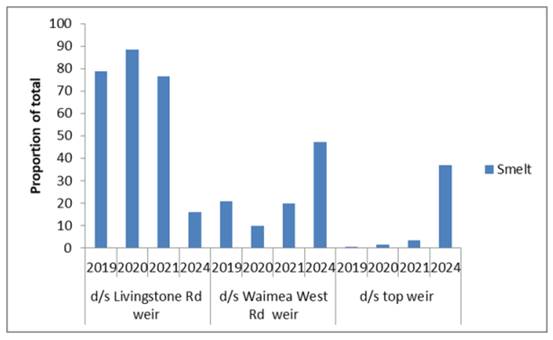
17.9 The
weir just downstream of Waimea West Road (Brightwater Bridge) appears to have
settled over the last few years and the overall gradient appears to have
relaxed a bit. There is also a lot more surface flow through the center
now. The weir downstream of Livingstone Road was re-constructed in late
2023 (see photo) and appears to be satisfactory from a fish passage point of
view and seems to be set lower than the original. At the time of the survey in
mid-January water was observed percolating through the rock rip-rap. It is
hoped that gravel will build up behind this and fill the spaces between the
rip-rap. We will need to keep monitoring this situation.
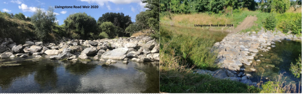
17.10 The low fish numbers between Waimea
confluence and Livingstone Road weir are probably in the most part due to
a lot of this reach being dry but could also reflect improved passage past the
Livingstone Road weir.
17.11 Draft plans for investigations into the
aquatic ecological effects of, and recovery from, low flow events have been
produced but will be difficult to resource until the new River Health Scientist
comes on board. Such investigations will include mapping changes in wetted
usable habitat area for fish which can be flown efficiently using drones. Water
temperature and dissolved oxygen will be important to measure also. In the
future we should be able to use green LiDAR are get the 3D wetted usable habitat,
which will be even more useful.
17.12 One of the areas in the district
most prone to loss of river habitat due to water availability in the river is
the Motueka River from the Motupiko River at Kohatu to the Wangapeka River.
Fortunately, this section of river has been studied extensively (particularly
during the Motueka ICM project from 2000-2010) and with the aid of two complex
models (one still being refined) we should be able to answer the question about
the extent of effects of water takes on this section of river. This is a
remarkably expensive and difficult question to answer precisely.
17.13 Alastair Clements
and Trevor James continue to work closely with our river engineers to achieve
results that are more cognizant of flooding hazards and are more ecologically
friendly. The relocation of the Rivers team to be in the same space as the
hazard and ecology teams has been beneficial and is seeing a more defendable
approach to river management.
17.14 Council has taken delivery of a digital river network that is
far more accurate than topographical maps or other digital network maps. This
relied on LiDAR coverage for the whole region (obtained in March 2023), a
rolling-ball model and a lot of checking (our summer student helped with this).
This tool will allow us to do GIS analysis that we have not previously been
able to do, such as map the extent of riparian tree cover, as well as the
observed cover, sinuosity and channel cross-section, for every reach of river
in the Tasman district.
18. Coastal and Estuarine
18.1 The fieldwork and reporting
on saltmarsh rehabilitation/restoration opportunities for the whole Waimea
Inlet has been completed. The sites were ranked according to the following
factors: existing values, potential biodiversity benefit (for birds, fish, plants
and invertebrates), proximity to existing restoration or good quality
saltmarsh, likely risk of failure and likely cost. This project was discussed
with Ngā iwi Te Tau Ihu with the possibility that we may introduce
cultural criteria to use in this process.
18.2 Estuary restoration
initiatives are becoming increasingly common in Aotearoa/NZ in recognition of
their high ecological and human use values, including shoreline protection, the
significance of past salt marsh losses and in supporting blue carbon initiatives.
18.3 We will use this report to guide our rehabilitation
and blue-carbon work with Waimea Inlet Forum, Tasman Environmental Trust and
other partners. A site adjacent to the Rough Island equestrian centre is ranked
highest (as discussed earlier in the report).
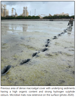
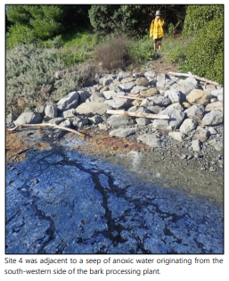
18.4 An investigation and report on potential nutrient sources affecting
algal blooms in the Eastern Waimea Inlet has been completed (see Environmental monitoring reports |
Tasman District Council). This is in
response to broad-scale mapping reports (also on the webpage link shown above)
showing this to be a consistent problem over successive monitoring events. The
main areas of the estuary affected are near the Bell Island wastewater
treatment plant outfall, around the mouths of creeks and near seepages around
the bark processing plant. Borck Creek and Seal Creeks (sites 5 and 8 on the
map below) appear to be the major contributors to the problem. Nutrient loads
based on modelling (CLUES) and actual measured load, appear to corroborate.
This is useful to know when setting limits in the Tasman Resource Management
Plan. Based on the nutrient loads present in the estuary, the expansion of the
spatial extent and density of some of the algal beds is likely to continue.
Workstreams in our Environmental Policy, Environmental Compliance and Catchment
Facilitator teams are working to address this.
18.5 The same sites also had sediment sampled for
nutrients, metals and semi-volatile organic contaminants. Apart from
naturally-elevated concentrations of nickel and chromium, as a result of the
Nelson Mineral Belt, none of the elements or chemicals tested were above
guideline values.
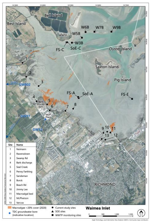
18.6 Fieldwork this summer is focused mainly on seagrass in the Whanganui
Inlet and for assessing saltmarsh restoration opportunities in the Moutere
Inlet. Our biennial sampling of sediment plates in the Moutere and Waimea
estuaries was undertaken in December 2023.
19. Conclusion/Discussion
19.1 As you can see the Environmental Information team covers a broad
range of areas and at any one time is engaged in a large workload. The team has
appreciated the trust shown by Council and enjoys the ability to get alongside
landowners and community groups to effect positive outcomes. With the recent
addition of the operation arm of the Rivers and Coastal Structures team we are
expecting to lift the management and dialogue around our rivers to recognise,
not just the immediate impact on adjacent landowners, but also the many
benefits and impacts of good river management on the wider catchment and in the
community at large.
19.2 While we are in a space of legislative change the core work
continues and we will continue to deliver effective and appropriate advice and
outcomes to our community.
Nil