Notice is given that an ordinary meeting of the Strategy and
Policy Committee will be held on:
MEMBERSHIP
|
Chairperson
|
Cr K Maling
|
|
|
Deputy Chairperson
|
Cr C Hill
|
|
|
Members
|
Mayor T King
|
Cr D McNamara
|
|
|
Cr S Bryant
|
Cr D Ogilvie
|
|
|
Cr C Butler
|
Cr T Tuffnell
|
|
|
Cr M Greening
|
Cr A Turley
|
|
|
Cr B Dowler
|
Cr T Walker
|
|
|
Cr C Mackenzie
|
Cr D Wensley
|
(Quorum 7 members)
|
|
|
Contact Telephone: 03 543 8578
Email: tara.fifield@tasman.govt.nz
Website: www.tasman.govt.nz
|
Tasman District Council
Strategy and Policy Committee Agenda – 30 September 2021
AGENDA
1 Opening, Welcome, KARAKIA
2 Apologies
and Leave of Absence
|
Recommendation
That apologies be
accepted.
|
3 Public
Forum
4 Declarations
of Interest
5 LATE
ITEMS
6 Confirmation
of minutes
|
That the minutes of the Strategy and Policy
Committee meeting held on Thursday, 8 July 2021, be confirmed as a true and
correct record of the meeting.
That the confidential minutes of the Strategy and
Policy Committee meeting held on Thursday, 8 July 2021, be confirmed as a
true and correct record of the meeting.
|
7 Reports of Committee
Nil
8 Presentations
8.1 (10.45
am) Future Growth in Mapua
Presentation..................................................... 4
9 Reports
9.1 (9.35
am) Chair's Report............................................................................................ 5
9.2 (9.40
am) Report on the
Resident Satisfaction Survey 2021.................................... 7
9.3 (10.00
am) Commencement of Plan Change -
Housing in Brightwater, Wakefield, Murchison, Mapua and Motueka.................................................................................. 113
9.4 (10.20
am) Strategic Policy and
Environmental Policy Activity Report....................... 126
9.5 (11.00
am) Notification of the Draft
Moutere-Waimea Ward Reserve Management Plan 192
9.6 (11.20
am) Climate Change Update............................................................................ 209
9.7 (11.40
am) Action Sheet.............................................................................................. 226
10 Confidential
Session
Nil
8 CLOSING
KARAKIA
Tasman District Council
Strategy and Policy Committee Agenda – 30 September 2021
8 Presentations
8.2
Future Growth in
Mapua Presentation
|
Report To:
|
Strategy and Policy
Committee
|
|
Meeting Date:
|
30 September 2021
|
|
Report Author:
|
Tara Fifield, Executive
Assistant - Service and Strategy
|
|
Report Number:
|
RSPC21-09-1
|
Jan Heijs will make a presentation
to the Committee on the future growth in Mapua.
Appendices
Nil
Tasman District Council
Strategy and Policy Committee Agenda – 30 September 2021
9 Reports
9.1
Chair's Report
Information Only - No Decision
Required
|
Report To:
|
Strategy and Policy
Committee
|
|
Meeting Date:
|
30 September 2021
|
|
Report Author:
|
Kit Maling, Chair - Strategy
and Policy Committee
|
|
Report Number:
|
RSPC21-08-2
|
1.1 This
is the Chair’s monthly report to the Strategy and Policy Committee.
|
That
the Strategy and Policy Committee receives the Chair's Report RSPC21-08-2
|
3.1 Welcome
everyone to today’s Strategy & Policy Committee meeting.
4 Special
Housing Areas Plan Change
4.1 The
Special Housing Areas Plan Change Hearing has been held and adjourned. A
site visit has been completed and we are yet to complete the deliberations at
the time of writing this report.
5.1 The
Three Waters Reform has been very topical over the last month and, as with
others, we are receiving numerous emails on this subject. At the time of
writing this report, we have yet to have our Full Council meeting on this
subject.
5.2 It
is more than a significant change for both our District and the rest of the
country and additional information is yet to be received in the final direction
that the Government will take. We will watch this space with interest, as
will our community.
Nil
Tasman District Council
Strategy and Policy Committee Agenda – 30 September 2021
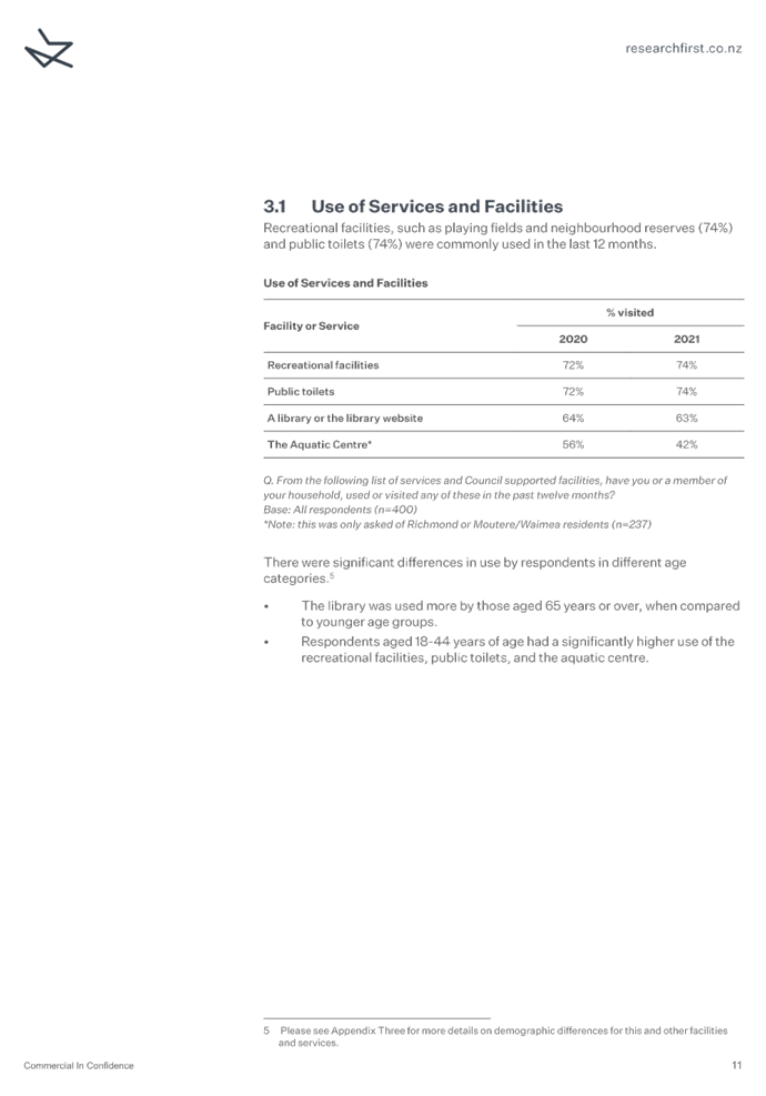
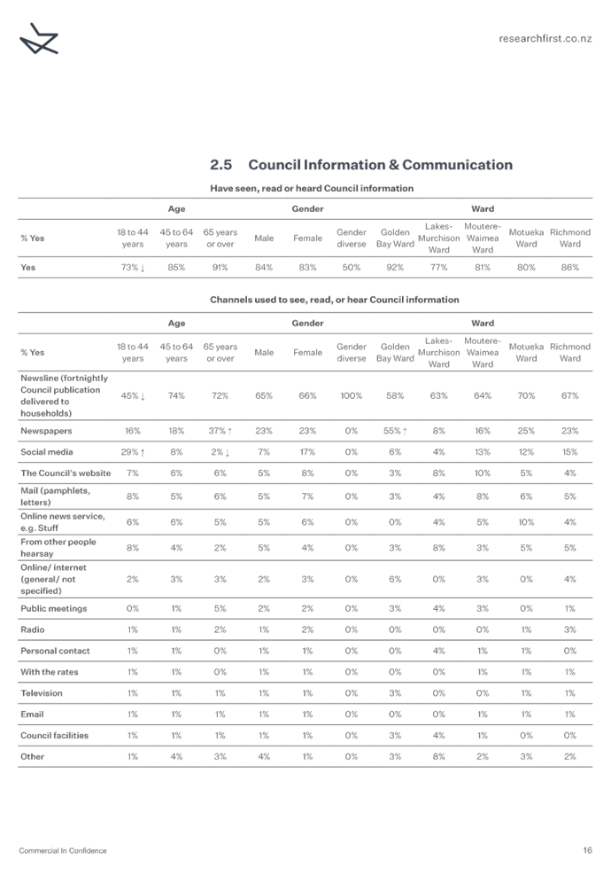
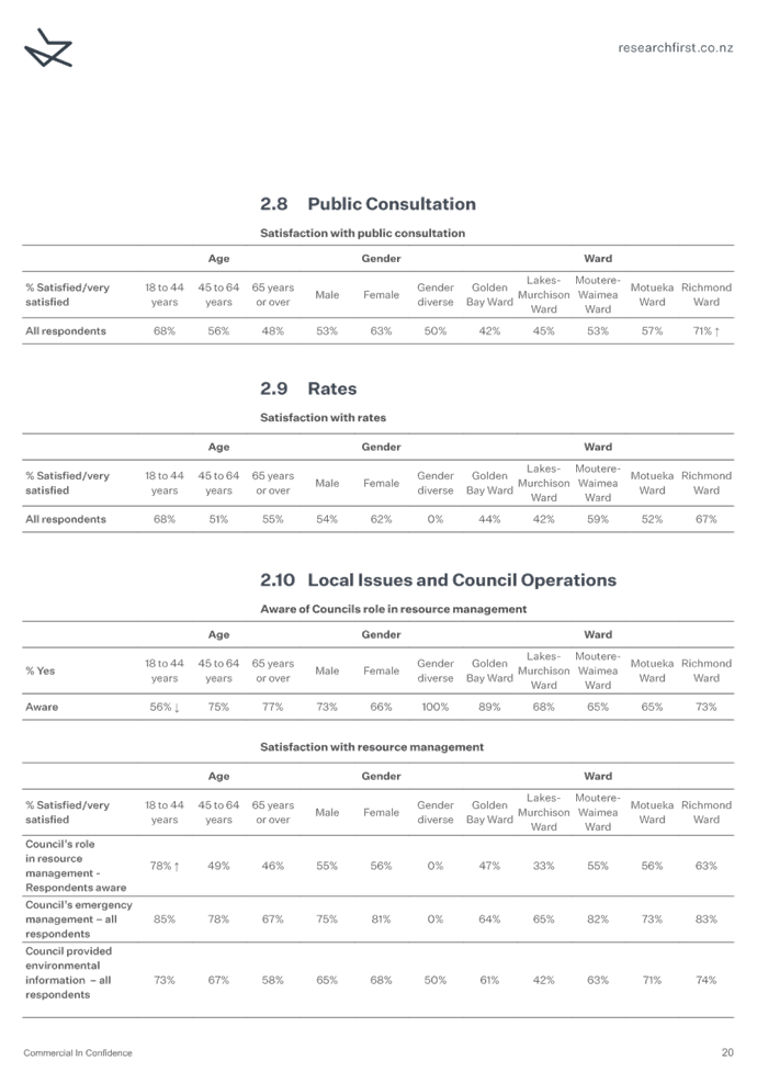
9.2 Report on the Resident Satisfaction Survey
2021
Information Only - No
Decision Required
|
Report To:
|
Strategy and
Policy Committee
|
|
Meeting Date:
|
30 September 2021
|
|
Report Author:
|
Sandra Hartley,
Policy Officer; Jamie McPherson, Transportation Manager
|
|
Report Number:
|
RSPC21-09-2
|
1.1 This
report provides the Strategy and Policy Committee with an overview and a copy
of the 2021 Annual Resident Survey report.
1.2 This year the Council engaged a new research provider to carry out
the annual Resident Satisfaction Survey, Research First. Adelaine Hansson, a
Senior Researcher from Research First, will be in attendance via Zoom to assist
with answering questions you may have.
1.3 The
survey was carried out in May, with 400 residents contacted by a mix of
landline or cell-phone numbers.
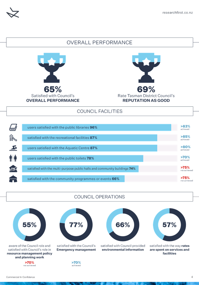
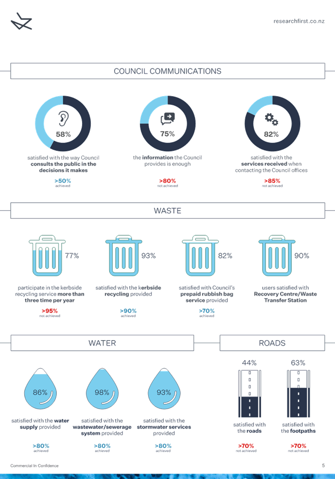
1.4 The
top three positive changes in satisfaction were for:
· public consultation;
· stormwater; and
· pre-paid rubbish bags.
1.5 The
top three negative changes in satisfaction were for:
· roading;
· the way rates are spent; and
· Council’s role in resource management.
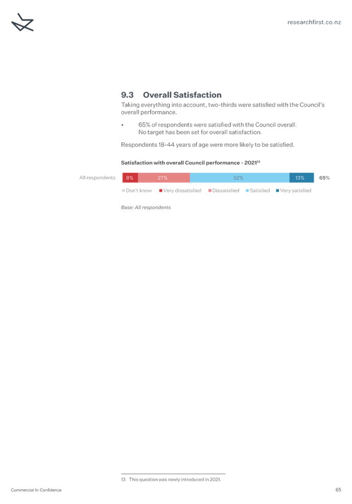
1.6 This
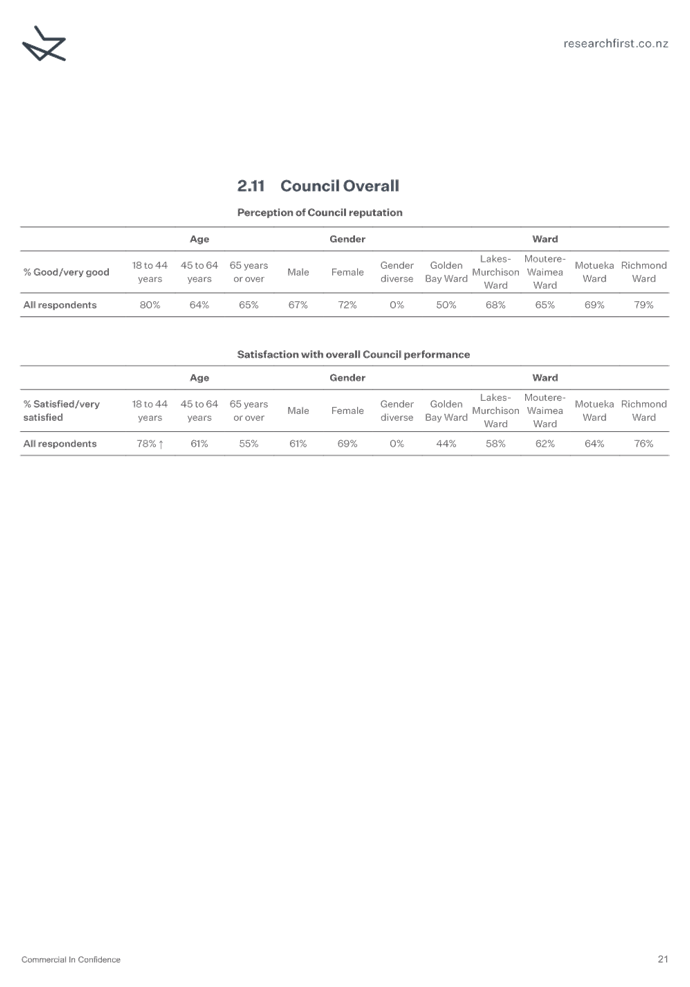
year was the first time that overall satisfaction with Council was measured,
with 65% of respondents satisfied.
1.7 There
were two notable changes in other measures (unrelated to satisfaction). They
were:
· 13% decrease in the number of people who have seen, read or heard
Council information (down from 96% in 2020); and
· 15% decrease in the number of people who felt Council had a good
reputation (down from 84% in 2020).
1.8 For
2021, where measures had a related level of service performance target, 11
services or facilities achieved the target, six did not achieve the target, and
one was not accurately measured. This is a change from 2020, where 14
services or facilities achieved the target, and four did not achieve the
target.
1.11 Much
of the information from the survey is used for the Council’s annual
reporting on performance measures in the Annual Report. Staff also use
the information regarding low satisfaction rates to help identify areas for
service improvements.
That the Strategy and Policy Committee:
1. receives the Report on the Resident Satisfaction
Survey 2021 report RSPC21-09-2; and
2. receives Resident Satisfaction Survey 2021 contained
in Attachment 1 to this report and the Resident Satisfaction Survey 2021
Appendix 3 contained in Attachment 2 to this report.
3.1 This
report provides the Strategy and Policy Committee with an overview and a copy
of the Resident Satisfaction Survey 2021 report.
3.2 There are a number of positive and negative movements in
satisfaction from last year. This report provides staff comment and analysis on
services or facilities that have seen a decline in satisfaction of more than
10%. It does not provide comprehensive analysis of other services or
facilities. If the Committee requests further analysis, staff can present
that information to a subsequent meeting.
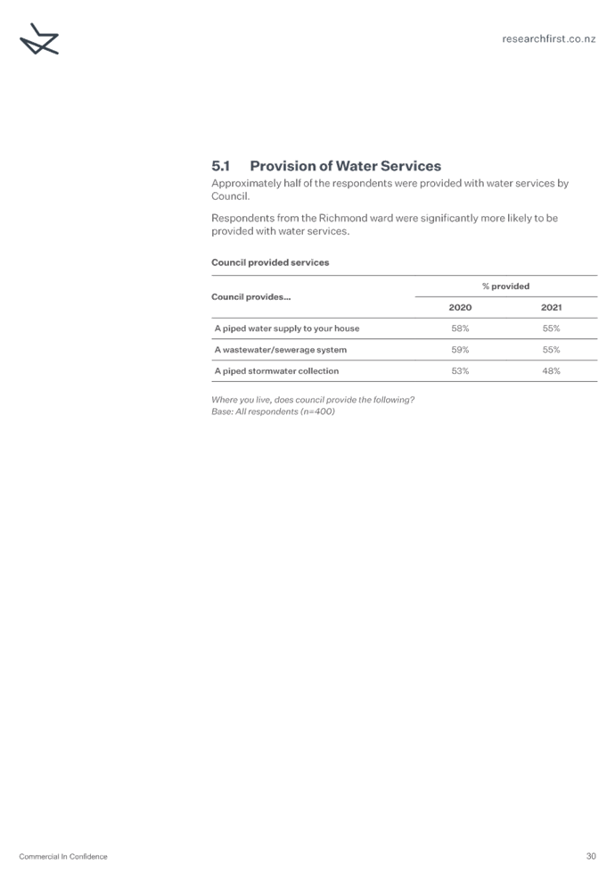
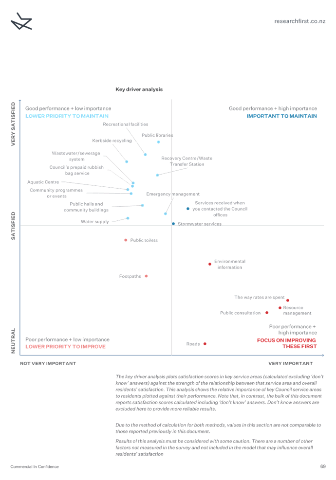
4 Research
Provider & Methodology
4.1 The
National Research Bureau (NRB) undertook the Council’s resident surveys
(CommunitrakTM) from 1996 to 2020. The contract with them
ended last year and, following a Request for Proposal
to research providers in New Zealand, Research First were engaged to provide
our annual resident satisfaction surveys for the next three years.
4.2 Research
First have undertaken resident satisfaction surveys for several councils since
2011.
4.3 Adelaine
Hansson, Senior Researcher for Research First and Project Manager for
Tasman’s Resident Satisfaction Survey, will be in attendance via Zoom at
this Strategy and Policy Committee meeting.
4.4 After
a pilot testing phase, the survey was carried out in May by contacting
residents by landline and cell-phone numbers from Research First’s
database of telephone numbers.
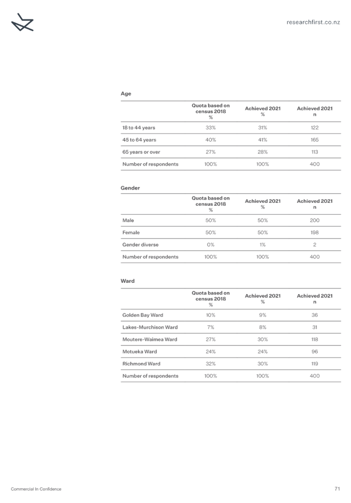
4.5 Between 1 May to 31 May, 400 residents
were contacted by landline (297) and by cell-phone (103) numbers. Quotas
based on age, ward and gender were required for the survey. Figure 1
shows the geographical distribution of respondents.
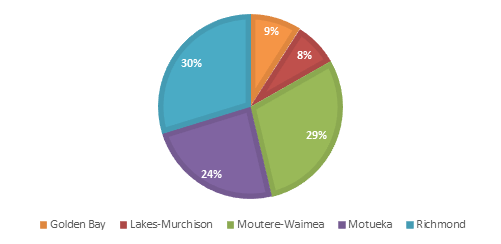
Figure 1: Percentage of interviews by ward
4.6 This
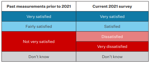
year we incorporated a new, more balanced satisfaction scale because the past
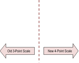
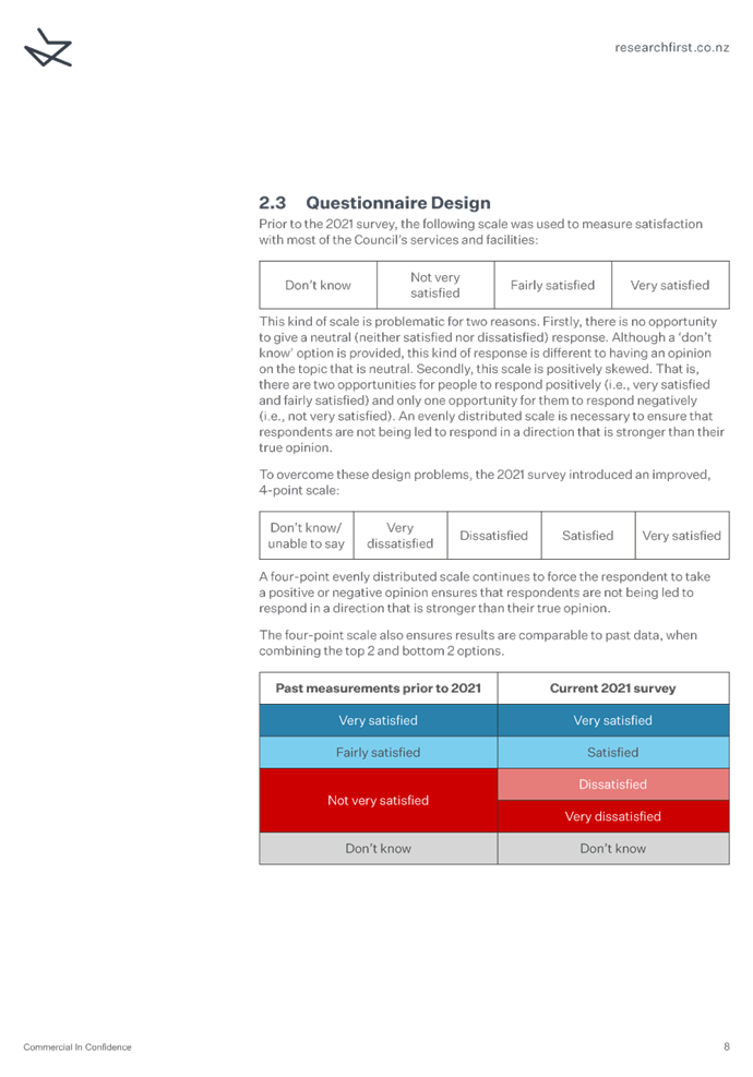
three-point scale was positively skewed. Refer to Table 1 for a comparison.
Table 1:
Comparison of response options
4.7 Attachment
1 provides a copy of Research First’s Resident Satisfaction Survey
Report 2021.
4.8 Attachment
2 provides a breakdown of results by age, gender and location.
Overview of Results
5.1 An
infographic summary and full breakdown of results are provided in Attachment
1. Below is a table that summarises the 2020 and 2021 results, the
movement in satisfaction, and whether the targets were achieved or not, for
each service or facility.
5.2 Research First have guaranteed a 95% level of confidence with the
survey results. This means that for the sample of respondents, the margin of
error is plus or minus 4.9%.
Table 2: Summary
of Satisfaction Results
|
Service/Facility
|
Satisfied 2021
|
Satisfied 2020
|
% Change
|
Target
|
Target Achieved
|
|
Overall satisfaction**
|
65% residents
|
N/A
|
N/A
|
No target
|
N/A
|
|
Public consultation
|
58% residents
|
48%
|
10% ↑
|
50%
|
Yes
|
|
Stormwater
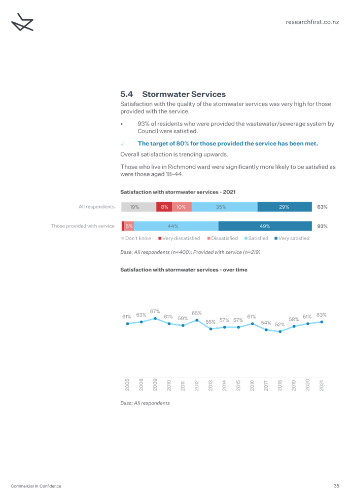
|
93% users
|
84%
|
9% ↑
|
80%
|
Yes
|
|
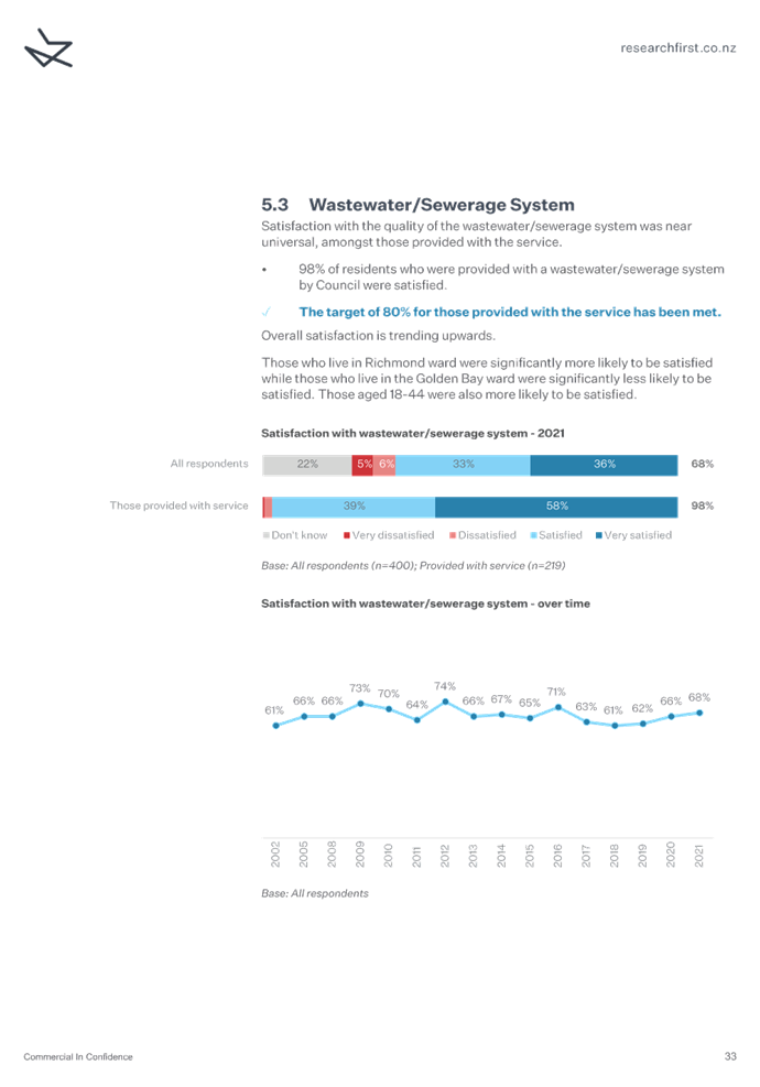
Wastewater/Sewage
|
98% users
|
92%
|
6% ↑
|
80%
|
Yes
|
|
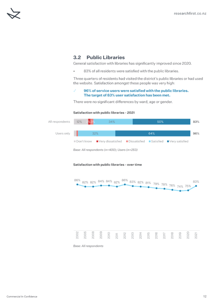
Public Libraries
|
96% users
|
91%
|
5% ↑
|
83%
|
Yes
|
|
Water Supply
|
86% users
|
81%
|
5% ↑
|
80%
|
Yes
|
|
Recovery Centre/Waste Transfer Station
|
90% users
|
88%
|
2% ↑
|
No target
|
N/A
|
|
Pre-paid rubbish bags
|
82% users
|
80%
|
2% ↑
|
70%
|
Yes
|
|
Kerbside Recycling
|
93% users
|
92%
|
1% ↑
|
90%
|
Yes
|
|
Environmental information
|
66% residents
|
66%
|
0%
|
No target
|
N/A
|
|
Emergency Management
|
77% residents
|
78%
|
1% ↓
|
70%
|
Yes
|
|
Recreational Facilities
|
92% users
|
95%
|
3% ↓
|
85%
|
Yes
|
|
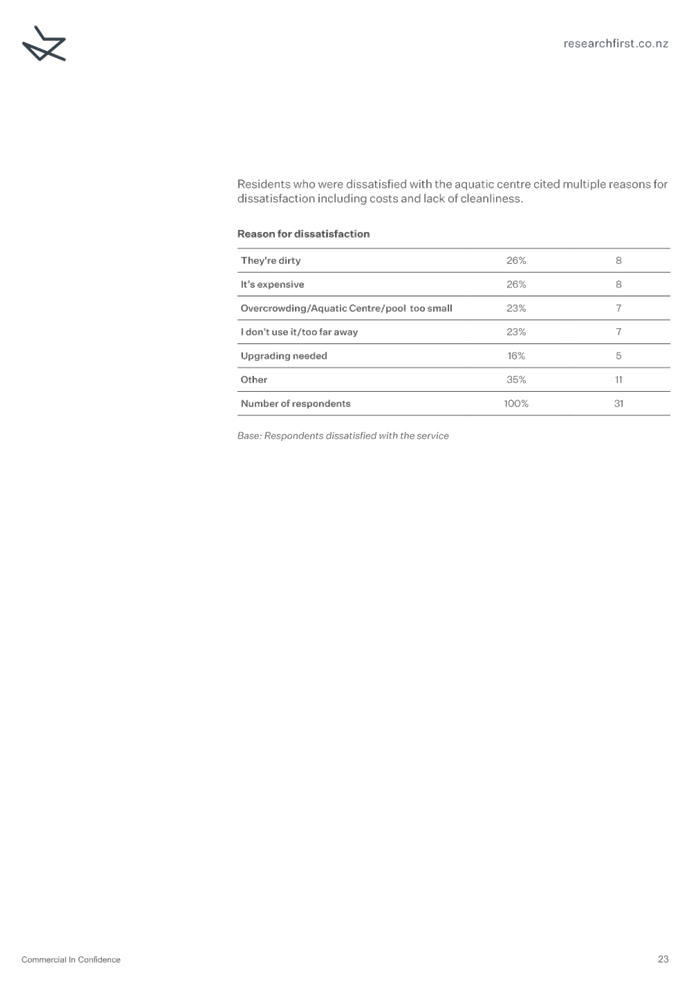
Aquatic Centre*
|
87% users
|
90%
|
3% ↓
|
70%
|
Yes
|
|
Public Toilets
|
78% users
|
81%
|
3% ↓
|
70%
|
Yes
|
|
Public
halls/community buildings
|
74% residents
|
77%
|
3% ↓
|
75%
|
No
|
|
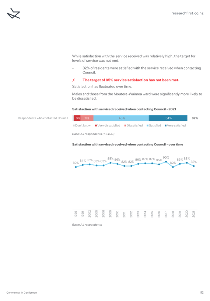
Service received when contacting Council
|
82% residents
|
88%
|
6% ↓
|
85%
|
No
|
|
Community Programmes & Events
|
66% residents
|
77%
|
11% ↓
|
75%
|
Not measured
|
|
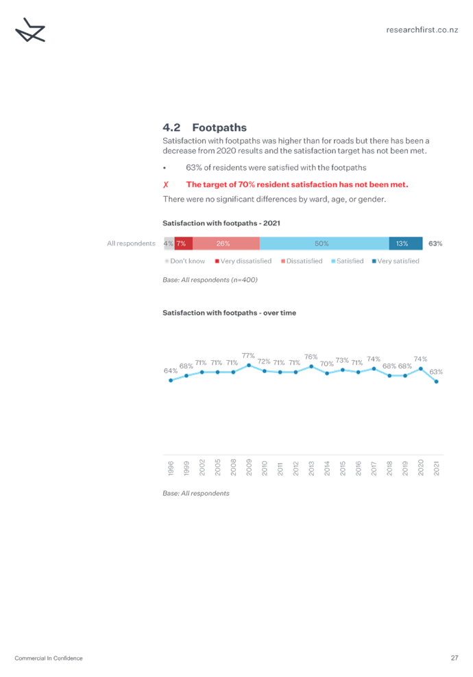
Footpaths
|
63% residents
|
74%
|
11% ↓
|
70%
|
No
|
|
Resource Management – respondents who were aware of
the Council’s role in resource management and policy and planning work
were asked how satisfied they were.
|
55% residents
|
69%
|
14% ↓
|
70%
|
No
|
|
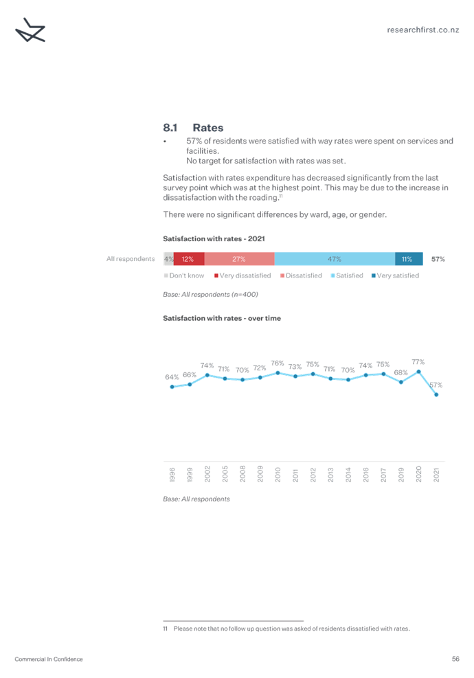
The way rates are spent
|
57% residents
|
77%
|
20% ↓
|
No target
|
N/A
|
|
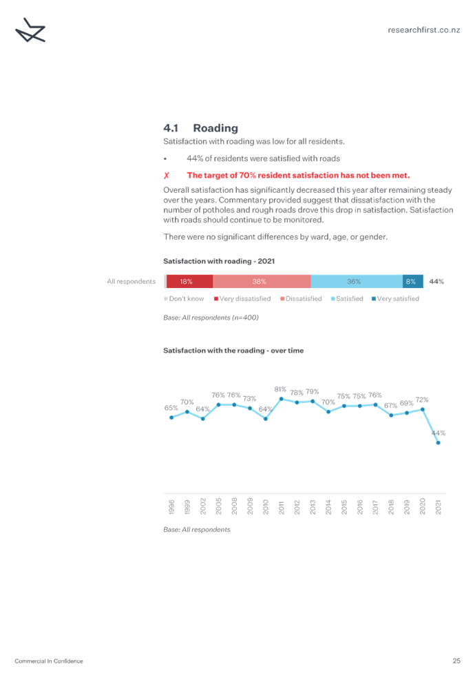
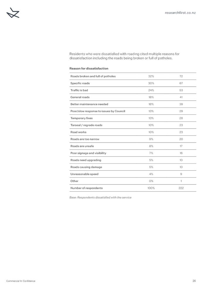
Roading
|
44% residents
|
72%
|
28% ↓
|
70%
|
No
|
5.3 The
survey question for Community Programmes and Events asked all respondents what
their level of satisfaction was regardless of whether they had attended an
event or not. The performance target specifies satisfaction of only those that
attended an event. Therefore, this performance target has been recorded as not
measured.
Table 3: Summary of Other Results
|
Service/Facility
|
% 2021
|
% 2020
|
% Change
|
Target
|
Target Met
|
|
Access to Council information
% of respondents
who have seen, read or heard Council information
|
83% residents
|
96%
|
13%↓
|
No target
|
N/A
|
|
Council
Reputation
% of respondents
who felt the Council’s reputation was good
|
69% residents
|
84%
|
15%↓
|
No target
|
N/A
|
|
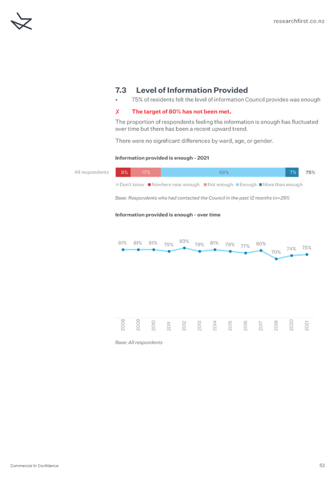
Level of Information Provided
% of residents who felt the level of information provided
by Council is enough
|
75% residents
|
74%
|
1%↑
|
80%
|
No
|
* only asked in Richmond and Moutere-Waimea Wards
**new question
↑ increase in satisfaction
↓decrease in satisfaction
Key Findings
5.4 The top three
positive changes in satisfaction were for:
· public consultation;
· stormwater; and
· pre-paid rubbish bags.
5.5 The
top three negative changes in satisfaction were for:
· roading;
· the way rates are spent; and
· Council’s role in resource management.
5.6 The
most notable drop in satisfaction with roading is discussed further in Section
6 of this report, along with other areas that have seen a decrease of more than
10%.
5.7 This
year was the first time that overall satisfaction with Council was measured,
with 65% of respondents satisfied.
5.8 There
were two notable changes in other measures (unrelated to satisfaction), they
were:
· 13% decrease in the number of people who have seen, read or heard
Council information; and
· 15% decrease in the number of people who felt Council had a good
reputation.
5.9 For
2021, where measures had a related level of service performance target, 11
services or facilities achieved the target, 6 did not achieve the target, and
one was not accurately measured. This is a change from 2020, where 14
services or facilities achieved the target, and four services or facilities did
not achieve the target.
5.10 Staff
are currently unable to provide benchmarking against other councils for 2021 as
other councils are yet to publish their results. Staff will present this
information to the Committee when it becomes available. The timing for this
will be dependent on other councils and staff have not yet been provided an
indicative timeframe.
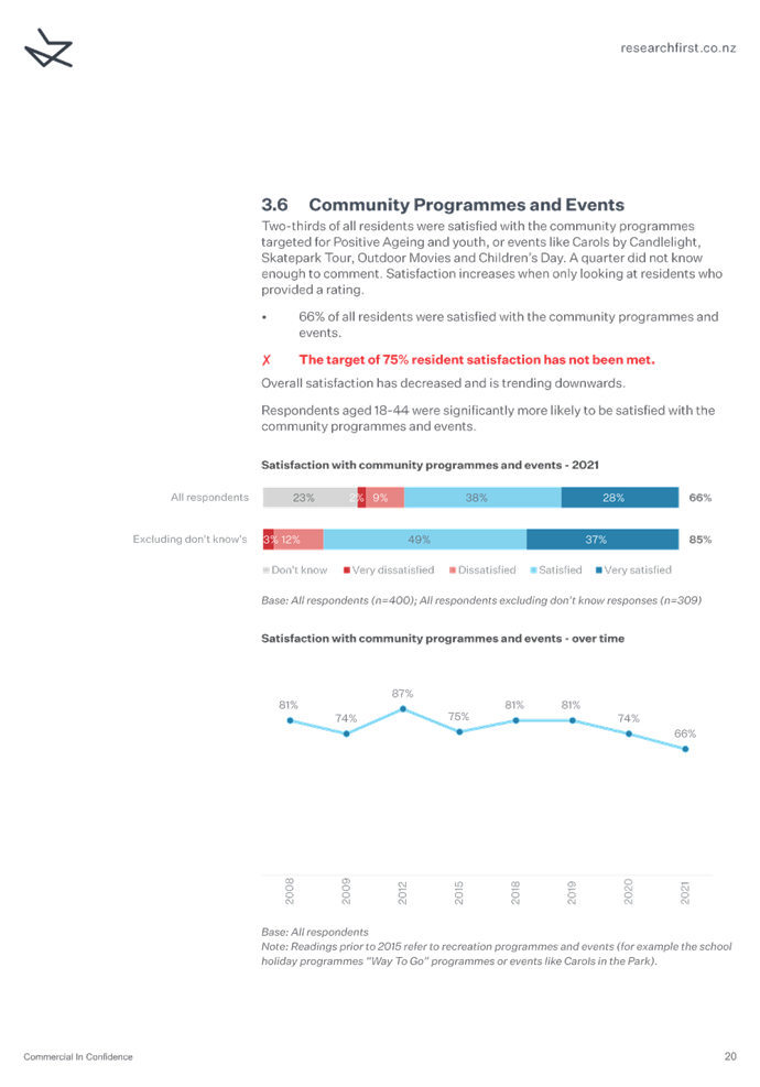
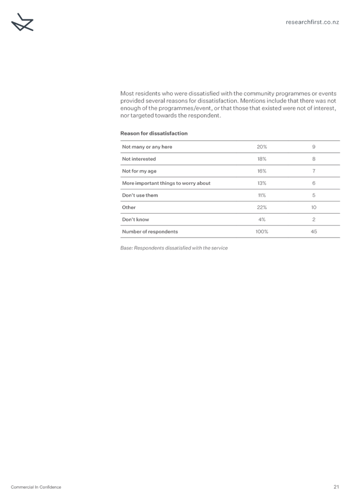
Community
Programmes & Events
6.1 The
annual residents survey 2021 showed a decline in apparent satisfaction with
community programmes and events compared with previous surveys. This section
discusses the results, apparent reasons for this change, and looks at whether
there are any issues that are not already being managed through the Long Term
Plan 2021-2031 and Activity Management Plan 2021-2051.
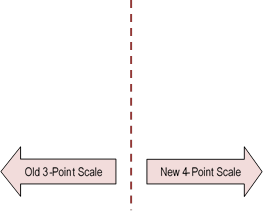
Figure 2:
Satisfaction with community programmes and events over time
6.2 As
alluded to above, the survey for Community Programmes and Events asked all
respondents what their level of satisfaction was regardless of whether they had
attended an event or not. The performance target specifies satisfaction of only
those that attended an event. Therefore, this data was not collected and the
performance target has been recorded as not measured.
6.3 Staff have analysed
the verbatim comments to better understand the issues that were
concerning survey respondents. The results are summarised in the table
below.
Table 4:
Analysis of verbatim comments for community programmes and events
|
Issue/Category
|
Number of Comments
|
Known Issue?
|
Management
Plan/Response
|
Satisfaction Outlook
|
|
Not interested in the events or the respondent
doesn’t attend them.
|
14
|
Yes
|
Ultimately our events will not appeal to
the full range of Tasman residents and there is a limited range of events
that the Council can facilitate within existing budgets. This may also be a
reflection that most events are predominantly held in the Richmond
area. Further consideration will be given to deliver events in regional
towns.
|
Slightly Positive
|
|
Not many, or any events held in the
respondent’s locality. Some residents specifically mentioned rural
areas and Golden Bay.
|
10
|
Yes
|
Again, this is likely to be reflection that most
events are predominantly held in the Richmond area. Further
consideration to be given to delivering events in other areas.
This may also be due to some residents being unaware
that Council supports but doesn’t necessarily lead some events e.g.
Matariki at Te Uma in Motueka which was led by Te Āwhina Marae.
Funding constraints do limit the number of events
that can be held, thereby limiting coverage across the District.
|
Slightly Positive
|
|
Not targeted to my age or my child’s age,
particularly teenagers.
|
4
|
No
|
Staff consider that a good range of
family friendly events are on offer. For example, movie nights and
Carols by Candlelight are welcome to all ages. Staff will discuss with the
Youth Council as to what improvements could be made to future events.
|
Slightly positive
|
|
Unaware of events taking place
|
5
|
No
|
Recreation events are well advertised
through a range advertising mediums, including our website, social media,
local newspapers, Itson, and Newsline. Staff routinely review appropriate
communication channels and will identify opportunities for improvement as
they arise.
|
Slightly positive
|
|
They think Council shouldn’t be providing
community events
|
3
|
Yes
|
Staff are aware some residents feel that
Council should focus on infrastructure or what they consider to be core
services. However, it is important for Council to enhance all four dimensions
of community well-being and the Community Outcomes.
|
Neutral
|
6.4 It is unclear why the service
has experienced a drop in satisfaction, especially when the events on offer are
inclusive and high quality. Next year staff will ensure that the survey
questions accurately reflect the performance measure and focus on residents who
attend events. There is some helpful feedback for staff to consider such as the
need to routinely assess community needs and tailor events accordingly.
Resource Management
6.5 The
annual resident survey 2021 showed a decline in apparent satisfaction with
those respondents who were aware of Council’s role in resource management
policy and planning work compared with previous surveys. This section discusses
the results and apparent reasons for this change.
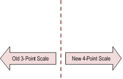
Figure 3:
Satisfaction with resource management over time
6.6 For
this service, there were no verbatim comments collected in the survey for staff
to analyse. Instead, staff have provided comments based on their understanding
of contextual matters at the time the survey was conducted.
6.7 The question around satisfaction with Council’s
resource management operations is meant to cover the environmental policy work
as there are other questions dealing with environmental information and a
separate survey on resource consents. However, when people are asked about
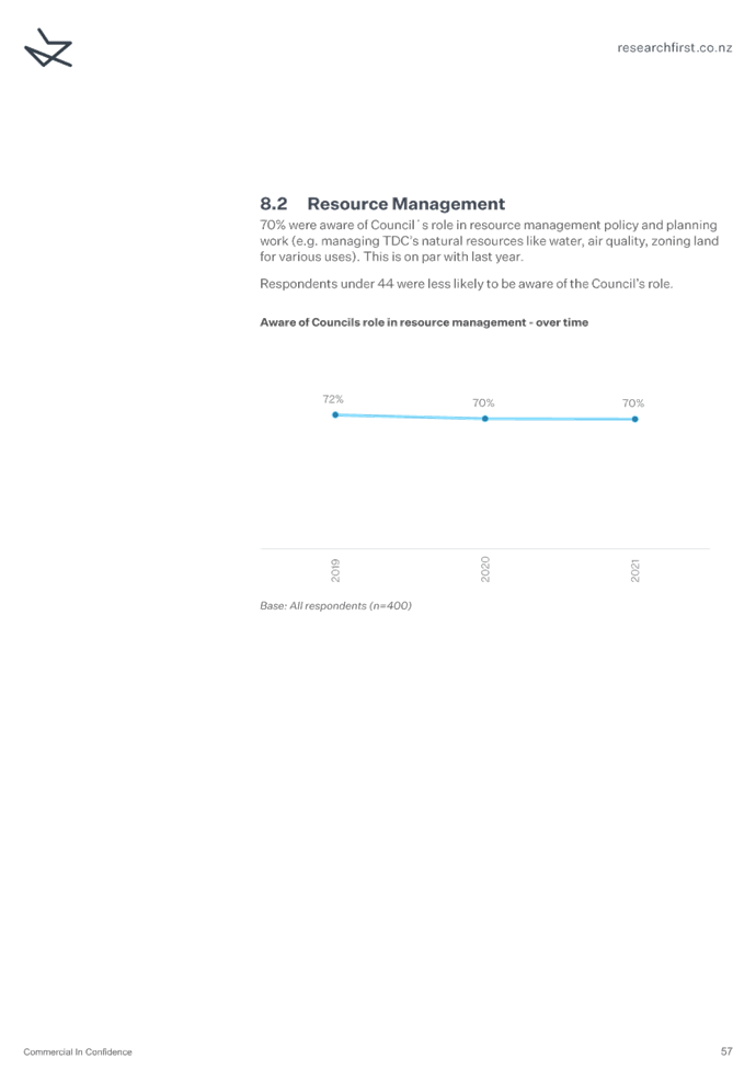
their satisfaction in the way Council manages natural resources like water, air
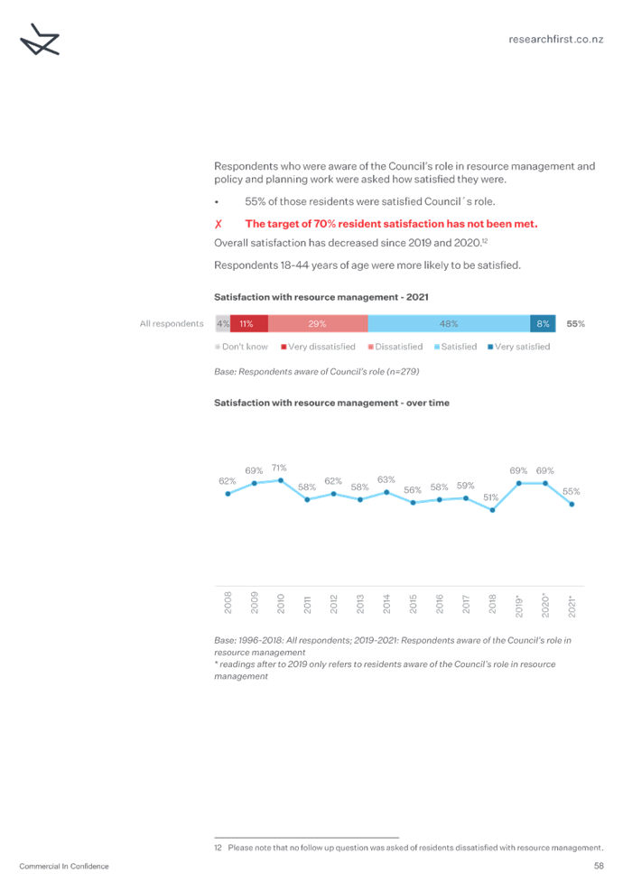
quality, zoning land, they may well conflate all functions. 70% of
respondents said they knew something of what the Council did in the activity
which is good with only 55% being satisfied or very satisfied (down from a
previous 69%). 40% were dissatisfied or very dissatisfied. The
survey corresponded with the rural push back on central government freshwater
regulations and significant natural areas and it should be noted that in the last
year, the Council has consulted on outstanding natural landscapes and coastal
hazards, subjects which have been challenging. The drop may well reflect this
sentiment and as we move into the review of Tasman Environment Plan, we will be
doing our best to engage with the community in an open and collaborative
manner.
Rates
6.8 The
annual resident survey 2021 showed a decline in respondents’ apparent
satisfaction with the way rates were spent on services and facilities compared
with previous surveys. This section discusses the results and apparent reasons
for this change.
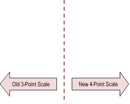
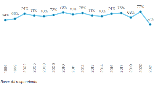
Figure 4:
Satisfaction with rates over time
6.9 For
this question, there were no verbatim comments collected in the survey for
staff to analyse. Instead, staff have provided comments based on their
understanding of contextual matters at the time the survey was conducted.
6.10 The
timing of the survey coincided with the development of the Long Term Plan
2021-2031. Through this process the Council agreed to increase the rates cap
from 3% to 4.5% for the first three years, rising to 7% for the next two years
with the last five years dropping back to 4.5%.
6.11 While
there were good reasons to do this, any increase in rates often attracts negative
publicity and staff believe this was reflected in the results.
6.12 The
Waimea Community Dam had also encountered cost overruns and a new targeted rate
was also being considered. While this did not eventuate, it was a topical issue
that gained a great deal of local attention.
6.13 Golden
Bay and Lakes/Murchison areas were the least satisfied with the way rates were
spent. In these areas, residents often perceive that they receive little
more than a road network in their areas given their remote nature.
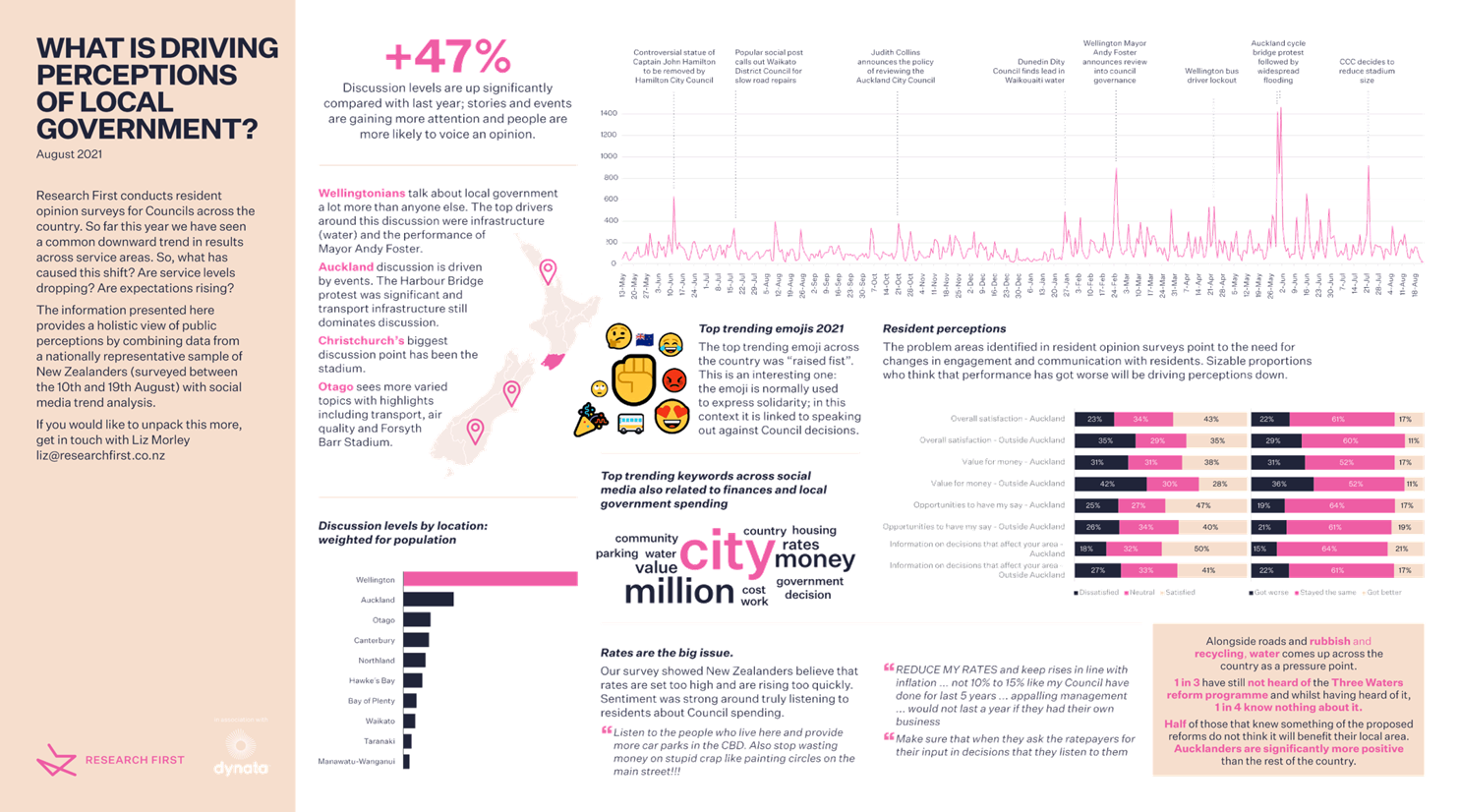
6.14 Our
research provider offers the following observations. “The information
from the national sample really focused on the drop in rates satisfaction being
driven by perceptions that residents keep getting asked to pay more but they
have little say about what that money is spent on. There is a real disconnect
between the visible areas of spending and perceptions of return on investment.
So, people are quick to tag on to examples of spending that they were not
consulted on, and that they individually can’t see the value of, they
then use this as a way to validate dissatisfaction. Those three areas that we
focused on in the data release are really closely linked: value for money,
opportunities to have my say and information on decisions that affect the area.
Where perceptions of value for money are low, perceptions on information
dissemination and community engagement are also likely to be low.” Refer
to Attachment 3 for further information.
Roads
6.15 The
annual resident survey 2021 showed a notable decline in apparent satisfaction
with roads and footpaths compared with previous surveys. This section discusses
the results, apparent reasons for this change, and looks at whether there are
any issues that are not already being managed through the Long Term Plan
2021-2031 and Activity Management Plan 2021-2051.
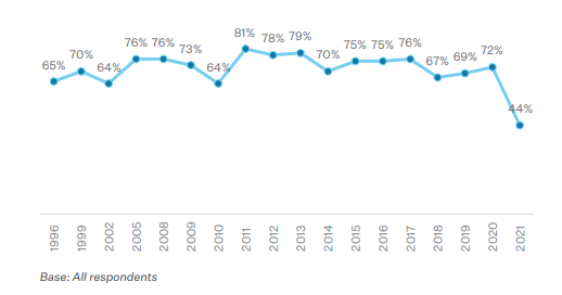
Figure 5:
Satisfaction with roading over time
6.16 Staff analysed
the verbatim comments to better understand the issues that were
concerning survey respondents. The results are summarised in the table
below.
Table 5: Analysis of verbatim comments for roads
|
Issue/Category
|
Number of Comments
|
Known Issue?
|
Management Plan/Response
|
Satisfaction
Outlook
|
|
Development
Congestion
Need upgrades
|
39
|
Yes
|
Key issue in Activity Management Plan
(AMP). Richmond Programme Business Case in progress. Walking and
Cycling Strategy in development. Congestion expected to increase with ongoing
growth and limited funding available for projects to offset it e.g. improving
walking and cycling, public transport.
|
Negative
|
|
State Highway complaint
|
37
|
Yes
|
Not relevant to Council
road network.
|
N/A
|
|
Patch Ups
Roadworks
Ageing Roads
|
32
|
Yes
|
Key issue in AMP. Relates to
reduced investment in resurfacing from 2015-2020 period. AMP proposes
to increase resurfacing from 2021 onwards but New Zealand Transport Agency
(NZTA) funding has not increased sufficiently. Actual resurfacing each
year will remain below sustainable level.
|
Negative
|
|
Roughness
Bumpy roads
|
32
|
Yes
|
Roughness on most categories of roads is
within Level of Service targets. The exception is arterial roads,
although Lower Queen Street has had smoothing works completed in June-July
2021 which will improve the result. Roughness will tend to increase
over time due to a low renewal rate and because roughness is not a reason to
renew pavements under NZTA funding rules.
|
Negative
|
|
Potholes
|
30
|
Yes
|
Key issue in AMP. Relates to
reduced investment in resurfacing from 2015-2020 period. AMP proposes
to increase resurfacing from 2021 onwards but NZTA funding has not increased
sufficiently. Actual resurfacing each year will remain below a sustainable
level.
|
Negative
|
|
Unsealed maintenance
|
21
|
Yes
|
Perennial issue, due to dynamic nature
of roads. Routine inspections show network condition
is within expected
range. Some additional metalling budgeted for
in Long Term Plan from 2021.
|
Slightly positive
|
|
Parking
Narrow Streets
|
18
|
Yes
|
Parking demand is increasing with growth
in Richmond. Town Centre Parking Strategy outlines Council
responses and interventions. More removal of on-street parking likely
on some roads to accommodate cycle lanes. Public consultation coming up
for Richmond Programme Business Case and Walking and Cycling Strategy, should
help inform community.
|
Slightly positive
|
|
Vegetation
Weeds
|
10
|
Yes
|
Perennial issue. No change proposed to
LOS currently offered.
|
Neutral
|
|
Speed limits - too high
|
9
|
Yes
|
Speed Management Plan being developed,
likely to result in (lower) safe and appropriate speeds being implemented
across the network over time.
|
Positive
|
|
Request more seal extensions
|
4
|
Yes
|
No plan to do more seal extensions due
to cost.
|
Neutral
|
|
Roadmarking
Signs
|
4
|
No
|
Maintenance specification needs review
to ensure high wear sites are being proactively treated.
|
Positive
|
|
Utility projects
|
4
|
Yes
|
Complaints about pipeline
installation/ replacement projects, not under control of road
activity.
|
Neutral
|
|
Drainage
|
3
|
Yes
|
Minor issue. AMP planned more
drainage maintenance and renewal but NZTA funding has not increased
sufficiently.
|
Slightly positive
|
|
Speed limits - too low
|
1
|
Yes
|
Speed Management Plan being developed,
likely to result in (lower) safe and appropriate speeds being implemented
across the network over time.
|
Negative
|
6.17 Most
of the issues are already well understood and specifically addressed in the
Council’s Transportation Activity Management Plan 2021-2051 and Long Term
Plan 2021-2031. However, the outlook for many of the issues is negative,
in that there is insufficient available funding to address them to the extent
that we could expect resident satisfaction to increase.
6.18 The
most common issue was the effects of development/congestion. The next
most common issues mentioned were specifically on State Highways, which are not
controlled by the Council. Issues related to potholes, road maintenance
and roughness were also common. As State Highways are the busiest roads
in the district, it is possible that some of the development/congestion issues
related to peoples experience on State Highways.
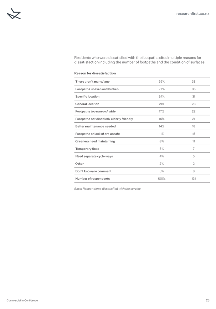
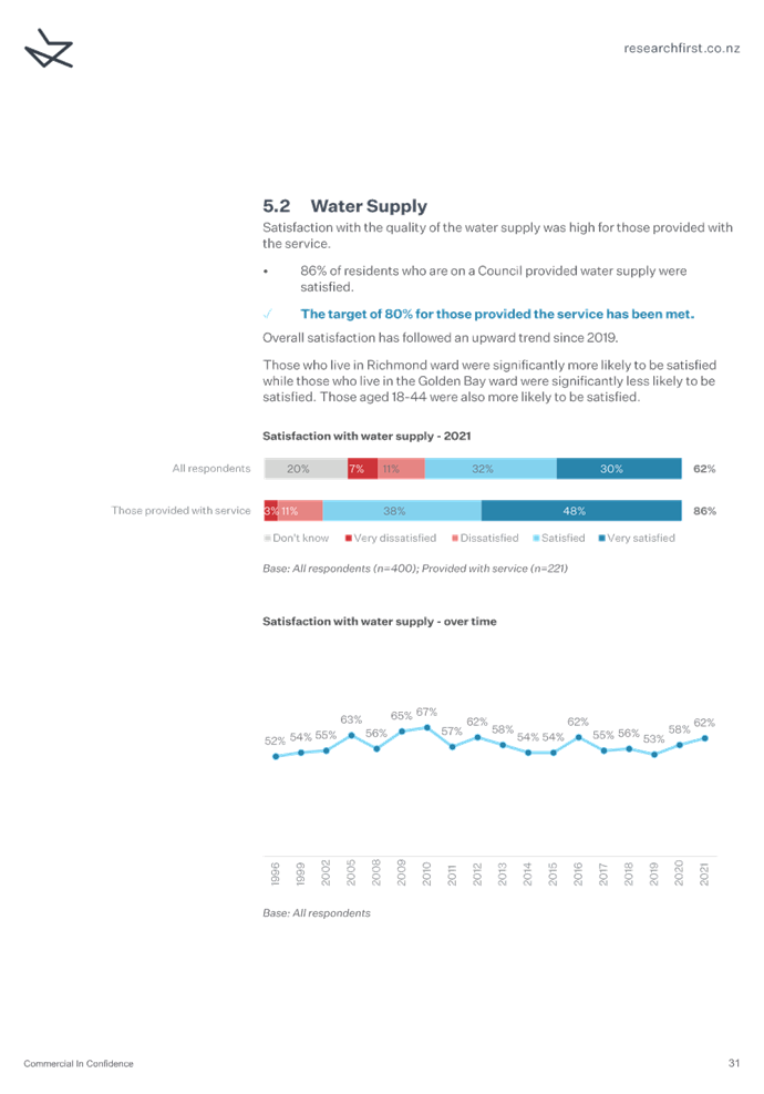
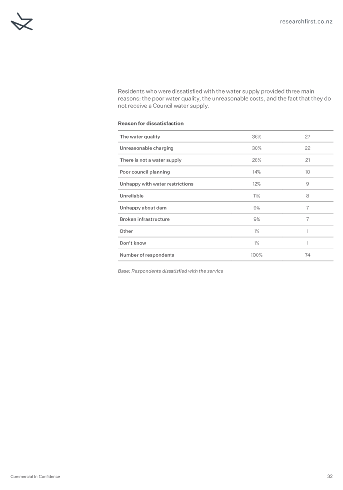
Footpaths
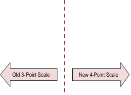
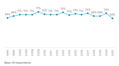
Figure 6:
Satisfaction with footpaths over time
6.19 Staff
analysed the verbatim comments to better understand the issues that were
concerning survey respondents. The results are summarised in the table
below.
Table 6: Analysis of verbatim comments for footpaths
|
Issue/Category
|
Number of Comments
|
Known Issue?
|
Management
Plan/Response
|
Satisfaction Outlook
|
|
No footpath / not
enough
|
40
|
Yes
|
Long Term Plan 2021-2031
(LTP) has small budget for new footpaths, but without NZTA funding for
2021-2024 it is likely a decrease overall. Only a small amount of
footpath will constructed each year, not enough to make a
difference to survey result.
|
Negative
|
|
Uneven
/ cracked
|
36
|
Yes
|
2020 Footpath condition
rating exceeded Level of Service target (95.8% in fair or better condition,
>95% target). Limited NZTA funding will put pressure on overall
maintenance and renewal budgets and future condition. Overall condition
unlikely to improve.
|
Negative
|
|
Too narrow/ next to
kerb
|
16
|
Yes
|
LTP has small budget for
improvements, but without NZTA funding for 2021-2024 it is likely a decrease
overall.
|
Negative
|
|
Vegetation
|
10
|
Yes
|
Perennial issue,
requires extra Council resources to proactively manage.
|
Neutral
|
|
Patches
/ potholes
|
8
|
Yes
|
2020 Footpath condition
rating exceeded Level of Service target (95.8% in fair or better condition,
>95% target). Limited NZTA funding will put pressure on overall
maintenance and renewal budgets and future condition.
|
Neutral
|
|
Behaviour of users
|
6
|
Yes
|
Share with care'
education campaign to be launched late 2021. Also awaiting outcome of
NZTA regulatory review which may legalise the use of footpaths by cyclists,
which would likely increase conflict between users.
|
Slightly positive
|
|
Too good / too
wide
|
4
|
No
|
Perception that
investment in paths should instead be put into roads. AMP already has
balanced approach
|
Neutral
|
|
Recycling or rubbish
bins on paths
|
3
|
Yes
|
Likely to get worse with
Richmond intensification and more bins put out on paths for collection
|
Negative
|
|
Parking on path
|
2
|
Yes
|
Enforcement issue
|
Neutral
|
|
Lack safe
crossings
|
2
|
Yes
|
LTP includes safety
improvement budget although lack of NZTA funding means less will be able to
be done.
|
Slightly positive
|
|
Lack of kerb on Queen
Street
|
2
|
Yes
|
No plan to change Queen
Street.
|
Neutral
|
|
Gravel not sealed
|
1
|
Yes
|
Limited improvement budget.
|
Neutral
|
|
Aesthetics
|
1
|
No
|
Not a Level of
Service.
|
Neutral
|
Roads and
Footpath Discussion
6.20 The
condition of our road and footpath network does not tend to change very
rapidly, so there is no obvious reason why satisfaction would have dropped so
substantially in real terms in 2021 compared with 2020. There are
potentially wider centrally-driven issues outside of the Council’s
control that could be influencing road user satisfaction, such as:
· awareness of lack of funding for road maintenance and improvements
in regions like Tasman and Nelson, and/or general dissatisfaction with how
funding is being distributed;
· National Policy Statement - Urban Development which requires
councils to enable more housing development;
· a push for safer speed limits arising from the Government’s
Vision Zero road safety strategy; and
· climate change and emissions awareness.
6.21 Aside
from these national-scale issues, staff have explored other specific matters
arising from the survey results.
6.22 The
scale prior to 2021 included what might be described as a ‘neutral’
score of ‘fairly satisfied’, which was the predominant response
people gave in previous surveys. This would have reflected that while
many people may have some issues related to road or footpaths that they
weren’t happy with, on balance they may consider themselves ‘fairly’
satisfied. However, the 2021 scale makes it much more black and white
without a ‘neutral’ score. It is possible that if previous
surveys had used a similar scale, that past road and footpath satisfaction
scores would also be lower.
6.23 While
staff understand the survey may advise respondents that the survey is not about
state highways, these roads inevitably lie at the heart of many journeys or at
least impact on them, and flavour overall perceptions. While state
highways have always been mentioned in residents’ surveys, there has been
noticeable deterioration in road condition, and increasing frustration at
congestion which primarily occurs on this busier network.
Road
Condition and Maintenance Funding
6.24 Funding for road maintenance through the current ‘co-funding’
approach involving Waka Kotahi introduces some risk to the road network if
insufficient co-funding is made available. For the 2018-2021 period, and
2021-2024 period, Waka Kotahi have provided less funding than the Council has
calculated is required to maintain the network. There appears to be a
view nationally that some road networks, including Tasman, are in ‘too
good’ condition and that some deterioration in overall condition may be
acceptable over time. Our view is that allowing condition to deteriorate
is risky and could cost more in the long term. Waka Kotahi funding for
2021-24 has been increased compared with 2018-21 which will enable the network
condition to be largely maintained, but not improved.
6.25 The
Council commissions independent Condition Rating of our sealed roads every 2
years. This enables calculation of a Condition Index (CI) which is an
overall reflection of sealed road condition. For CI a lower score means better
condition. A score of 0-2 is considered excellent, 2-5 is very good, 5-10
is average and so on. Our network overall is in very good (almost
excellent) condition although the trend is that condition is slowly
deteriorating.
Figure 7:
Network Condition Index Over Time
6.26 It
should be noted that the roughness (or bumpiness) of our road network
is also generally very good compared with our peers at other
provincial councils. Only our arterial roads, which make up 0.7% of
our network, have been measured as rougher than our peer group.
This is primarily due to Lower Queen Street, which has been in a holding
pattern while various underground services have been upgraded in recent
years. A smoother asphalt surface has been laid (after
the residents’ survey) on rougher parts of this road in June/July
2021 which will improve roughness. See Figure 8. Note a lower
roughness score equates to a smoother road. The 85th
percentile is considered a representative roughness score – 15% of any
given road will have a roughness higher than this number.
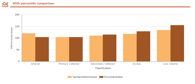
Figure 8: 85th
Percentile Comparison for Roughness
6.27 Interestingly,
using a measure called Smooth Travel Exposure (STE), which considers the
proportion of trips that are made on roads that exceed a certain roughness
threshold, Tasman fares better than our peer group for all road
classifications. This shows that drivers experience slightly smoother trips on
our road network than on our peer groups networks. See Figure 9. In this
graph, a higher score is better and represents more vehicle trips being
undertaken on smooth roads.
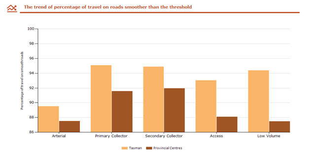
Figure 9:
Smooth Travel Exposure
6.28 Clearly
the dissatisfaction of our residents with the road condition
reflects some desire for an unachievable and unaffordable
condition.
Roads and
Footpaths Conclusion
6.29 Resident
satisfaction has likely changed as a result of the change in survey methodology
and a perceived lack of focus and investment on
improving our roads due to growth in the district, rather than as a
result of actual changing network condition.
6.30 In
almost all cases the issues identified by residents have already been
considered by the Council’s Transportation Activity Management
Plan.
6.31 Based
on the survey results and this analysis, satisfaction with roads and footpaths
is unlikely to improve in the next few years given the limited amount of
funding available to make progress on the issues identified.
Access to Council Information
6.32 This
question measured the percentage of residents that saw, read, or heard Council
information in the last 12 months. This year the percentage was 83% which is
down from last year by 13%. This question did not ask respondents about whether
they were satisfied with the communications they received or not.
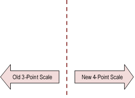
Figure 10:
Access to Council information over time
6.33 The
survey did show that the most commonly seen Council communication resource was
Newsline.
6.34 It
is difficult for staff to determine why less people have seen, read, or heard
from Council. 38% of respondents said they preferred face to face customer
counter interactions with the Council. To some extent this has been limited by
Covid-19 restrictions at times and could have had a small impact on whether
people felt like they had heard from Council or not. Also, as more transactions
are possible online, e.g. dog registrations, this could have had an impact.
6.35 Encouragingly,
there were increases in satisfaction in two related communication questions:
· 75% of residents felt the level of information Council provided was
enough, this is an increase of 1%.
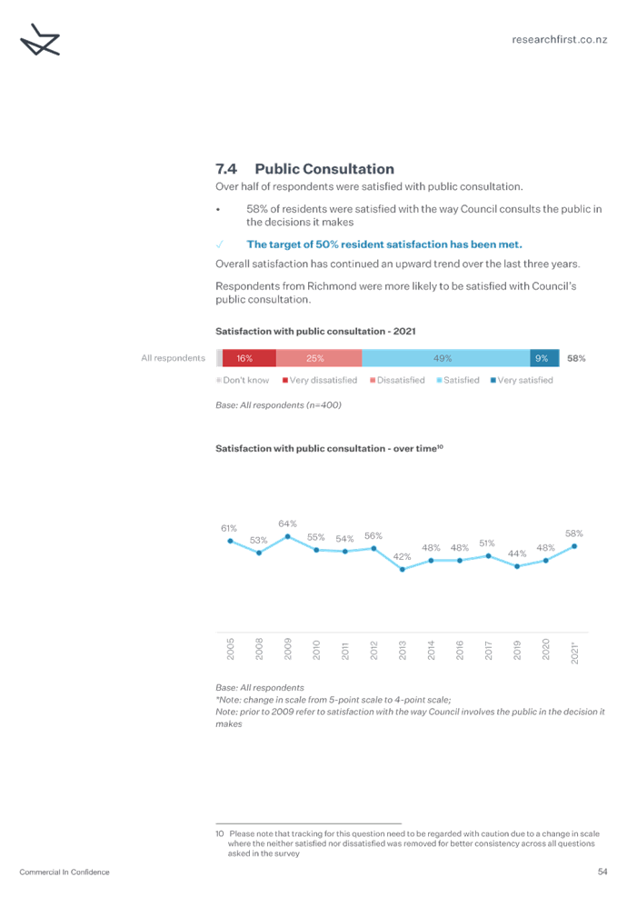
· 58% of residents were satisfied with the way Council consults the
public in the decisions it makes, this was an increase of 10%.
Council
Reputation
6.36 This
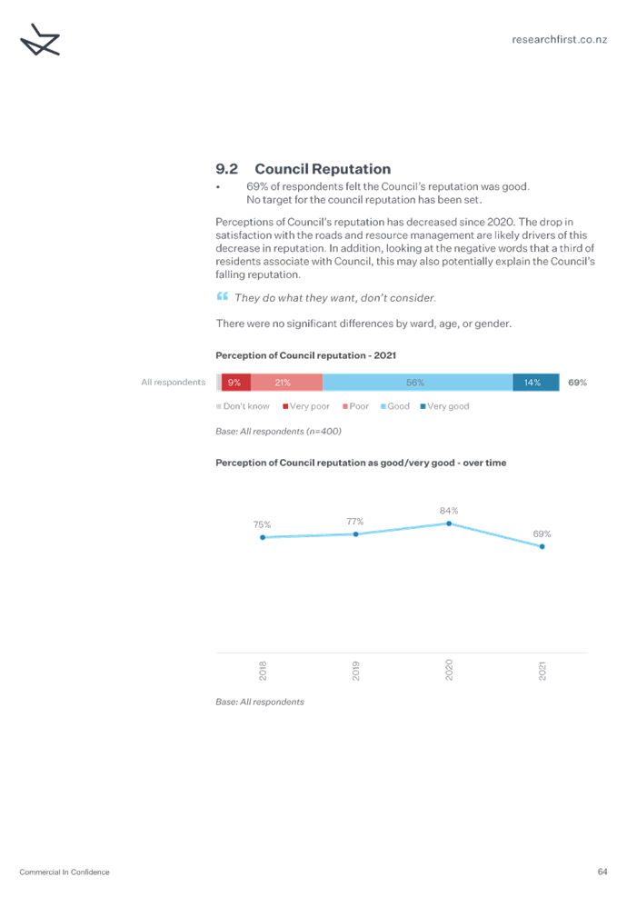
year, 69% of respondent felt the Council’s reputation was good. This is
down from last year by 15%.
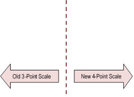
Figure 11:
Satisfaction with Council reputation
6.37 Council’s
reputation is an overall measure and will be reflective of many of the points
previously discussed in this report. For this reason, staff have not provided
further analysis or discussion.
7 Conclusion
and Next Steps
7.1 Our
annual residents’ telephone survey was carried out in May, with our new
provider Research First.
7.2 Of the 18 performance measures, 11 met their target, 7 did not, and
1 was not accurately measured.
7.3 Information
from the survey will be used to report against the Council’s performance
measure targets in the Annual Report 2020/2021. Staff also use the information
regarding low satisfaction rates to help identify areas for service
improvements.
7.4 Staff
will also prepare a summary of the key results for inclusion in a future
edition of Newsline.
|
1.⇩
|
Resident Satisfaction Survey Report
2021
|
26
|
|
2.⇩
|
Resident Satisfaction Survey -
Appendix Three
|
98
|
|
3.⇩
|
Perceptions of Local Government
August 2021
|
111
|
Tasman District Council
Strategy and Policy Committee Agenda – 30 September 2021


Tasman District Council Strategy and Policy Committee Agenda – 30 September 2021

Tasman District Council Strategy and Policy Committee Agenda – 30 September 2021
Tasman District Council
Strategy and Policy Committee Agenda – 30 September 2021
9.3 Commencement of Plan Change - Housing in
Brightwater, Wakefield, Murchison, Mapua and Motueka
|
Report To:
|
Strategy and Policy
Committee
|
|
Meeting Date:
|
30 September 2021
|
|
Report Author:
|
Jeremy Butler, Team Leader -
Urban and Rural Policy; Barry Johnson, Environmental Policy Manager
|
|
Report Number:
|
RSPC21-09-3
|
1.1 Tasman
is experiencing high rates of urban growth and demand for new housing. The
Nelson Tasman Future Development Strategy has a target of providing 40% of new
housing through intensification.
1.2 This
paper outlines proposals to rezone land for housing in Murchison, Brightwater,
Wakefield, Mapua and to change the residential rules for Motueka West,
Wakefield and Mapua to provide a more enabling consenting framework for higher
housing densities. This will have the benefit of incentivising more
efficient use of land for housing and contributes to implementing the Nelson
Tasman Future Development Strategy (FDS).
1.3 The
areas included in this paper are either already zoned for residential use or
identified in the FDS as potential sites for growth or intensification.
1.4 In
summary the proposals are:
· Brightwater – re-zoning of land identified in the FDS for
housing;
· Wakefield - a combination of rule changes to enable higher densities
and some additional re-zoning to make the most efficient use of the available
land;
· Murchison – identification of land for re-zoning to
residential and rural residential. The FDS identifies some possible
locations;
· Mapua – re-zoning of rural residential land to residential as
identified in the FDS for intensification; and
· Motueka - rule changes to enable higher densities on residentially
zoned land identified in the FDS for intensification.
That
the Strategy and Policy Committee:
1. receives
the Commencement of Plan Change - Housing in Brightwater, Wakefield,
Murchison, Mapua and Motueka RSPC21-09-3; and
2. approves the commencement of work to scope and develop
a plan change or changes to address urban growth pressures and the demand for
housing in Brightwater, Wakefield, Murchison, Mapua and Motueka;
and
3. instructs
staff to report back to the Strategy and Policy Committee on recommendations
for a draft plan change or changes following scoping of possible plan changes in Brightwater, Wakefield, Murchison,
Mapua and Motueka.
3.1 To
seek approval to scope plan changes to rezone land for housing in Murchison,
Brightwater, Wakefield, Mapua and to change the residential rules for Motueka
West, Wakefield and Mapua to provide a more enabling consenting framework for
higher housing densities.
3.2 To
seek approval to develop a draft plan change or changes to be bought back to
the Strategy and Policy committee for a decision on whether to then proceed to
non-statutory consultation on the drafts ahead of any formal plan change
process.
4 Background
and Discussion
4.1 Tasman
District is experiencing very high rates of urban growth and housing shortages.
The year ending May 2021, saw a record 633 building consents issued for new
dwellings. House prices continue to increase. According to the Real
Estate Institute of NZ (REINZ) the median house price in Tasman was a record
$850,000 in May 2021, an increase of 21% since May 2020. The demand for
new housing is also creating a tension with the ongoing loss of productive
land.
4.2 While
we currently have adequate capacity on paper as defined by the NPS-UD, there
are opportunities to maximise the use of existing zoned land through amending
rules to enable higher densities, more choice and more efficient use of that
land. This is the case in Motueka, Mapua and Wakefield. Demand is uneven
across the District and in Murchison there is demand but the owners of land
that is currently zoned for residential uses are not interested in developing.
There is a similar situation in Brightwater where current zoning is creating
barriers to the development of land zoned or identified through the Future
Development Strategy (FDS) for housing.
4.3 The
aim of the proposals set out in this report is to address a combination of
shortages in housing supply in Murchison and by providing sufficient levels of
zoned land that can be developed at higher densities in the townships that need
it most.
4.4 The
next Strategy & Policy Committee meeting will also receive a paper
outlining growth pressures in Richmond and options to address those pressures.
Murchison
4.5 While
growth predictions for Murchison are low, there is evidence of a real shortage
of housing and accommodation. Multiple conversations with various Murchison
business owners, the school principal, real estate agents indicate there is
clear evidence that there is a requirement for more residential and rural
residential land in Murchison with a particular urgency for more residential
land.
4.6 The
landowners of existing deferred residential land have indicated they have no
interest in developing. To meet demand, staff initial investigations have
identified two possible locations for residential zoning (Figure 1). The
first is an area that straddles Fairfax Street on the southern boundary of
Murchison. The second is a large block of land bounded by Hotham Street,
Chalgrave Street and the State Highway on the western side of Murchison.
4.7 Part
of the Fairfax Street site is identified in the FDS for future growth. The
other site is not. This is a very early indication of possible locations
for additional residential land. A detailed assessment of servicing will
be required along with discussions with landowners to determine the feasibility
of the sites. If the Committee supports proceeding, then staff will complete an
assessment of servicing, hazards, landowner interest and staff will come back
to you with detailed recommendations on potential areas for re-zoning.
4.8 We
are also proposing to scope potential locations of land for rural residential
development. This will be done in conjunction with landowners and the
community. Any potential rural residential locations will be assessed and
presented to the Committee for consideration.
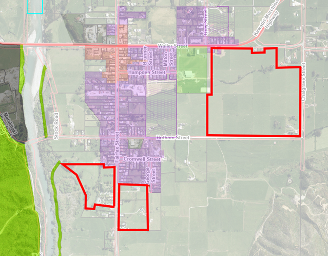
Figure 1. location of
potential sites for re-zoning land for residential development.
Brightwater
4.9 The proposal
for Brightwater is to bring forward the re-zoning of a block of land identified
in the FDS as being needed in approximately 7-17 years to meet demand.
Growth in Brightwater could in theory be accommodated for the next 7-10 years
by uplifting deferred zoned land adjacent to the Ernest Rutherford
memorial. However, the landowner has indicated that it is not feasible to
develop just the deferred land. The block of deferred land and the adjacent area
identified in the FDS is in single ownership, except for a smaller holding in
the very south-west corner (Figure 2). The owners have indicated that if the
area identified in the FDS is not zoned residential they are likely to plant
grapes on the majority of the block which will mean it is lost for housing for
a long time.
4.10 This
is also an opportunity to review the residential rules that apply to the whole
area to determine if they could be amended to enable higher housing densities.
The current rules for the deferred residential land enable standard or
comprehensive development.
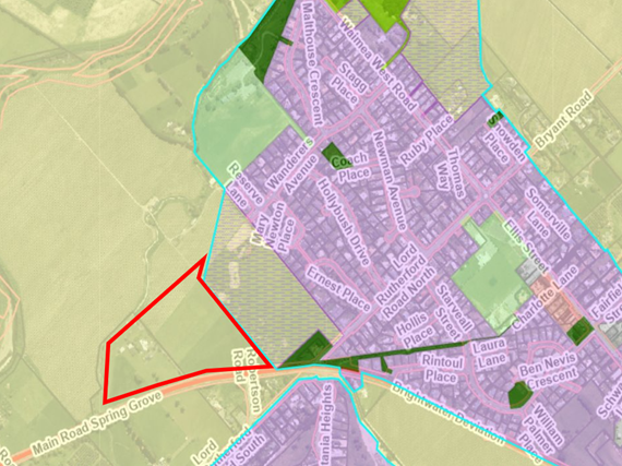
Figure 2. location of
land proposed for re-zoning for residential development.
4.11 There
is also a small area of land that requires a reassessment of the underlying
zones on Waimea West Road (Figure 3). The proposal is to amend the zones
that apply to land located at 366 and 368 Waimea West Road to align with a
subdivision boundary adjustment that was undertaken in 2007.
4.12 The
subdivision relocated the boundaries of two titles. The owner at the time of
title CTNL107/125 approached Council, as did the owner of the neighboring title
CTNL107/124, to carry out a boundary adjustment to enable an existing house,
which was located close to Waimea West Road to be relocated toward the rear of
the site.
4.13 The
intention of the parties was that following the boundary relocation, the
portions of land exchanged that were amalgamated into the existing titles,
would be rezoned in line with existing zonings and intended new uses as shown
below.
4.14 The
subdivision was duly completed but the rezoning of the land (from Recreation to
Rural 1 and vice-versa) exchanged was not.
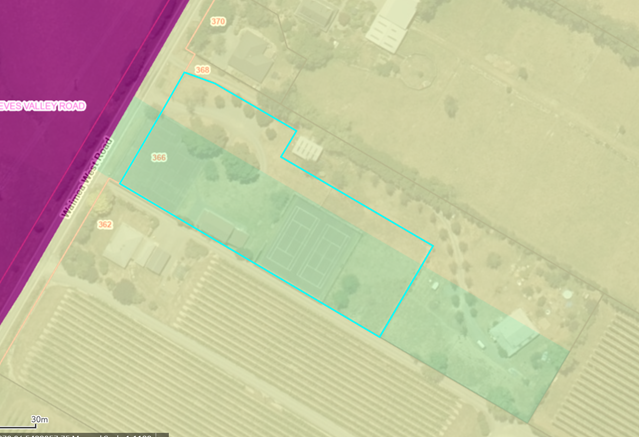
Figure 3. Current
zoning of 366 and 368 Waimea West road. Council recreation property outlined in
blue. Green is Recreation zone, yellow is Rural 1 zone.
Wakefield
4.15 The
proposal for Wakefield covers an area of land with mixed zoning off Edward
Street (Figure 4). The proposal is to increase the area of land within the same
boundary that is residentially zoned and amend the rules to enable higher
densities to make the most efficient use of the available land for
housing. The land is residential on the western side of a tributary of
Pitfure Stream and rural residential on the eastern side with a large strip of
rural one land separating the two, to accommodate potential flood flows. New
flood modelling indicates that the area required to accommodate flood flows can
be reduced.
4.16 We
have had initial discussions with the landowner who is supportive of the
proposal. If the Committee supports proceeding, then an assessment of servicing
and hazards will be completed and staff will come back to you with detailed
recommendations on changes to zoning and rules that could apply to this
site. The current rules for the residential land enable standard or
comprehensive development. The rural residential land is deferred to ensure
access in a Q100 event; and for provision of a pedestrian/cycle link over the
Pitfure Stream.
Figure
4: Location of site proposed for changes to zoning and development rules.
Mapua
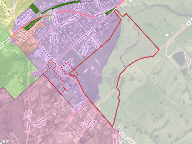
4.17 In
Mapua, the proposal is to rezone three areas of land in Seaton Valley road from
Rural Residential to Residential to enable higher housing densities (Figure 5).
These areas are identified in the FDS for intensification from decade two (7-17
years away). This proposal would enable intensification to occur earlier. Given
the land is currently zoned rural residential then it can be developed now
which would effectively mean the opportunity to provide more houses in this area
would be lost.
4.18 The
three areas of rural residential land identified in the FDS for intensification
are:
· Seaton Valley Flats - 12 hectares, the proposal is for standard
density, with an estimated yield of estimated yield 119 homes;
· Seaton Valley Hills – 21 hectares, the proposal is for medium
to low density, with an estimated yield of 500 homes in FDS; and
· Seaton Valley Northern Hills – 16 hectares, the proposal is
for medium to low density, with an estimated yield of 12 homes in FDS.
4.19 Initial
discussions with some of the landowners indicate they support the proposals.
There is sufficient wastewater, water and stormwater servicing (proposed in the
Long Term Plan 2021-2031) within the defined area of the map. If the Committee
supports proceeding, then staff will come back to you with detailed
recommendations on the spatial extent of changes to zoning and the rules that
could apply to these sites.
4.20 The
area of low-lying land adjacent to Seaton Valley Road is proposed to be used as
a communal stormwater detention for contributing catchments with sports fields
and passive transport connections. The upper portion of this land has an
indicative reserve overlay on it as it has been identified as the location for
new sports fields.
4.21 The
entire parcel has been included in an Infrastructure Acceleration Fund
application and we expect to hear back in October whether this has been
successful.
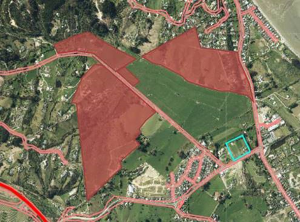
Figure 5:
location of areas to consider for intensification.
Motueka West -
Whakarewa Street
4.22 The
proposal for Motueka West is to amend the current Tasman Resource Management
Plan (TRMP) rules to enable higher densities. The land is currently deferred
residential: standard density (Figure 6).
4.23 The
area is part of a larger area identified in the FDS for intensification from
decade two (7‑17 years away). However, development of the larger
area is dependent on servicing. Further work is needed to align the staged
infrastructure servicing plans with the landowners’ development
stages.
4.24 The
landowners are supportive and have plans for higher than standard housing
densities. Amending the rules to enable higher densities will support
those plans.
4.25
If the Committee supports proceeding, then staff will come back to you with
detailed recommendations on amendments to the current residential rules that
could apply to this site.
Figure 6. location
land identified for intensification (red)
5.1 The
options are outlined in the following table.
|
|
Option
|
Advantage
|
Disadvantage
|
|
1.
|
Proceed with the proposals
outlined in this report
|
Allows more efficient use of land
for housing. Higher densities can potentially reduce pressure for further
expansion onto productive land.
|
Creates additional demands on the
Environmental Policy Team that could risk delivery of the new plan,
|
|
2.
|
Proceed with a selection of the
proposals
|
Will enable
intensification/growth in some towns.
|
If some areas are rejected, then
the opportunity for intensified development is likely to be lost. Existing
land shortages in some areas would continue.
|
|
3.
|
Don’t proceed with the
proposals
|
No additional cost to Council.
|
Opportunity to maximise the use
of greenfield land for new housing is lost. Existing pressure on loss of
productive land will continue. Existing housing shortage in some locations
will continue.
|
5.2 Option
one is recommended.
6.1 There
are no identified risks associated with development of draft plan changes.
There will be several opportunities for community comment and input. We
will also ensure we work with iwi on the proposals.
6.2 There
is likely to be a reasonable amount of community interest in the proposals and
ensuring adequate opportunities for community input will help to ensure the
proposals reflect community input.
7 Policy
/ Legal Requirements / Plan
7.1 Parts
of Tasman District form the Nelson Tasman Tier 2 Urban Environment under the
National Policy Statement – Urban Development 2020 (NPS-UD). These
comprise Richmond, Brightwater, Wakefield, Māpua and Motueka. Policy
2 of the NPS-UD requires Tier 2 local authorities, at all times to provide at
least sufficient development capacity to meet expected demand for housing and
for business land over the short, medium and long term.
7.2 The
FDS provides a long term indication of where and how growth will be catered for
in terms of both new land for housing and business and also where
intensification can potentially occur. The proposals in this report are
the next step in implementing that strategy. Most of Tasman’s towns
are built on or close to productive land and urban expansion is constantly
eroding the amount of productive land available. The FDS seeks to
minimise urban expansion over productive land and enabling higher housing
densities will help by making the most efficient use of the land that is lost
to primary production.
7.3 Enabling
intensive housing helps to provide a diversity and choice of housing density
and form to cater for a growing population, a changing demographic profile and
a range of living options.
7.4 Section
31 (1) (aa) of the RMA “the establishment, implementation, and review of
objectives, policies, and methods to ensure that there is sufficient
development capacity in relation to housing and business land to meet the
expected demands of the region” is relevant to these proposals.
Intensification is being proposed as a way of meeting some of the increased
demand for housing in the district. The contribution intensification can
make has been estimated in the 2019 FDS as 40% of additional housing capacity
across the region (60% of additional capacity within the Nelson Urban Area
(Nelson, Tahunanui, Stoke, Richmond, and Hope)). This is predicated on
the areas identified in the FDS for intensification being re-zoned to enable
higher densities of housing.
7.5 If
the proposals proceed then staff will develop draft plan changes. These will be
released for stakeholder and community feedback. Once the draft plan
changes are finalised, they will be notified in accordance with the
requirements of Schedule 1 of the Resource Management Act 1991. This
process involves notification, submissions, further submissions, hearings and
then notification of a decision. Subject to no appeals on the decision,
the plan change can be made operative.
8 Consideration
of Financial or Budgetary Implications
8.1 There
will be additional costs associated with bringing forward the rezoning and
rules changes for these areas. Given demand, it is considered a
priority. There are two options to cover the costs. A request has
been submitted for additional budget through the activity balances carry
overs. Council will be asked to consider this when it receives the
activity balances carry over report. If the request isn’t successful,
then some of the work on the Tasman Environment Plan will have to be
re-prioritised and pushed out to next financial year.
8.2 Early
indications are there will be no additional cost in relation to servicing. The
areas identified in this report are either already serviced or services are
planned through the LTP. However staff will confirm this as part of
bringing preferred options back to the committee.
9 Significance
and Engagement
9.1 There
is likely to be a reasonable amount of interest in these proposals given the
topical nature of housing. Community groups and associations will be
interested in proposals to provide for higher density housing in their
communities. We are not expecting any significant opposition. The Murchison & Districts Community Council has
recently written to the Council requesting an urgent plan change to provide
additional land for housing. The Committee will view a presentation
at this meeting requesting it enable intensification in Mapua. There has
been further anecdotal information that suggests there will be a reasonable
amount of support for the proposals in this report. There will be
several opportunities for community input into these proposals initially
informally as the draft changes are developed and then formally through the
statutory plan change process.
|
|
Issue
|
Level of Significance
|
Explanation of Assessment
|
|
1.
|
Is there a high level of public interest, or is decision
likely to be controversial?
|
Medium
|
Housing is very topical. Any proposals that
involve urban growth are likely to attract a lot of interest.
|
|
2.
|
Are there impacts on the social, economic, environmental
or cultural aspects of well-being of the community in the present or future?
|
Medium
|
The proposals are seeking to address some of the issues
associated with the housing shortage and high house prices in Tasman.
Staff anticipate that the proposals should have positive impacts on the social, economic, environmental or
cultural aspects of well-being of the community.
|
|
3.
|
Is there a significant impact arising from duration of
the effects from the decision?
|
High
|
The proposals to enable higher densities will result in
long term impact through the creation of new communities and new housing.
|
|
4.
|
Does this activity contribute or detract from one of
the goals in the Tasman Climate Action Plan 2019?
|
Medium
|
Higher housing densities is likely to mitigate transport
emissions if we don’t need to expand out as fast with accompanying
travel emission impacts
|
|
5.
|
Does the decision relate to a strategic asset?
|
No
|
|
|
6.
|
Does the decision create a substantial change in the
level of service provided by Council?
|
No
|
|
|
7.
|
Does the proposal, activity or decision substantially
affect debt, rates or Council finances in any one year or more of the LTP?
|
No
|
|
|
8.
|
Does the decision involve the sale of a substantial
proportion or controlling interest in a CCO or CCTO?
|
No
|
|
|
9.
|
Does the proposal or decision involve entry into a
private sector partnership or contract to carry out the deliver on any
Council group of activities?
|
No
|
|
|
10.
|
Does the proposal or decision involve Council exiting
from or entering into a group of activities?
|
No
|
|
|
11.
|
Does the proposal require inclusion of Māori in the
decision making process (consistent with s81 of the LGA)?
|
Yes
|
The Resource Management Act codifies the engagement
required with iwi on plan changes.
|
10.1 The
proposals outlined in this report present an opportunity to make more efficient
use of land that has been identified for housing by enabling higher densities
and to address local shortages of land for new housing. The proposals
also have the potential to mitigate some of the pressure for expansion onto
productive land. They also contribute to the implementation of the FDS by
re-zoning some areas of land that are identified in the FDS as areas for
intensification.
11.1 If
approved the proposals in this paper will be scoped in consultation with
landowners and stakeholders before final recommendations are presented to the
Committee on whether specific proposals should proceed and in what particular
form. That would be followed by the release of draft plan changes for
feedback and then a formal RMA Schedule 1 plan change process follows.
Before public notification, Council is required to have prepared a Section 32
report which is made available at the time of notification of the Proposed Plan
Change.
Nil
Tasman District Council
Strategy and Policy Committee Agenda – 30 September 2021
9.4 Strategic Policy and Environmental Policy
Activity Report
Decision Required
|
Report To:
|
Strategy and Policy
Committee
|
|
Meeting Date:
|
30 September 2021
|
|
Report Author:
|
Barry Johnson, Environmental
Policy Manager; Wouter Woortman, Senior Infrastructure Planning Advisor -
Stormwater; Dwayne Fletcher, Strategic Policy Manager; Alan Bywater, Team
Leader - Community Policy
|
|
Report Number:
|
RSPC21-09-4
|
1.1 This report
provides the Committee with an update on some of the key highlights of the
Service and Strategy Group’s strategic policy and environmental policy
work.
1.2 The report
also provides a revised timeline for the Annual Plan 2022/2023.
1.3 The report
seeks approval to adopt and publicly notify the decisions of the hearing panel
for Plan Change 71 - Coastal Occupation Charges and Plan Change 72 - Moorings
and Coastal Structures in accordance with the First Schedule of the Resource
Management Act 1991.
1.4 The report
seeks a resolution to uplift the deferred zone status on land in Māpua.
1.5 The report
seeks a resolution for the Mayor in conjunction with the Mayor of Nelson to
write to Te Tau Ihu Iwi to request nominations for a Matauranga Māori
(Māori knowledge) representative to sit on the Future Development Strategy
hearings panel in 2022.
1.6 The report
provides a revised programme for the completion of the review of
Council’s involvement in older persons housing.
That
the Strategy and Policy Committee:
1. receives
the Strategic Policy and Environmental Policy Activity Report RSPC21-09-4;
and
2. notes
the timetable for preparation of the Annual Plan 2022/2023, as follows; and
|
15 December 2021
|
Council workshop – Review
revised budgets, rates impact on example properties and for staff to
recommend whether consultation is required.
|
|
23 February 2021
|
Council workshop – Review revised budgets,
rates impact on example properties and further discuss whether consultation
is required
|
|
31 March 2022
|
Full Council meeting – adopt
Draft Annual Plan 2022/2023 and information for consultation
|
|
4 April – 4 May 2022
|
Public consultation
|
|
11-12 May 2022
|
Hearings
|
|
25 May 2022
|
Deliberations Meeting
|
|
23 June 2022
|
Full Council Meeting – Adopt
Annual Plan 2022/2023
|
N.B. The latter part of this timeline will
vary if the decision is taken not to consult on the Annual Plan.
3. receives
the recommended decisions from the Hearing Panel for Plan Change 71 – Coastal
Occupation Charges (Attachment 1 dated 19 August 2021) and Plan Change 72
– Moorings and Coastal Structures (Attachment 2 dated 19 August 2021);
and
4. accepts
the recommended decisions for Plan Change 71 – Coastal Occupation Charges
(Attachment 1) and Plan Change 72 – Moorings and Coastal Structures
(Attachment 2) as the decisions of the Committee; and
5. agrees
to publicly notify the decisions for Plan Change 71- Coastal Occupation Charges
and Plan Change 72- Moorings and Coastal Structures as soon as practicable and
in accordance with the First Schedule of the Resource Management Act 1991; and
6. agrees
to adopt Plan Change 71 – Coastal Occupation Charges and Plan Change 72
– Moorings and Coastal Structures, and affix the Tasman District Council
Seal to the adopted plan changes, where no appeals to the Environment Court are
received; and
7. agrees
to refer the adopted plan change as set out in Attachments 1 and 2 to the
Minister of Conservation for approval; and
8. notes
that following approval from the Minister of Conservation, Plan Change 71
– Coastal Occupation Charges and Plan Change 72 – Moorings and
Coastal Structures will be publicly notified as operative as required by
Schedule 1 of the Resource Management Act 1991; and
9. receives
the information contained in this report on the Uplift of Deferred Zone –
part of 166 Mapua Drive; and
10. agrees
to the removal of ‘Rural 1 deferred Residential zone’ status and
replacement with ‘Residential zone’ status for part of the property
located at 166 Mapua Drive, being described as: Lot 2 DP479544; and
11. agrees
that an invitation is made to Te Tau Ihu Iwi for a
Matauranga Māori (Māori knowledge) representative to sit on the
Future Development Strategy hearings panel in 2022 (the invitation will be
made jointly by the Mayors of Tasman and Nelson); and
12. agrees
to continue the review of Council’s older persons housing in accordance
with the following programme:
|
Milestone
|
Completion
|
|
Steering
Group workshop – agree options for consultation
|
October
2021
|
|
Development
of options document
|
November
– December 2021
|
|
Initial Community Board, iwi and other stakeholder options
consultation
|
February
– April 2022
|
|
Steering Group consideration of consultation feedback
|
May
2022
|
|
Council agreement to preferred option
|
June
2022
|
|
Development of draft consultation document for LTP amendment and
audit of the document
|
July
– September 2022
|
|
Adoption of draft consultation document by Council
|
September
2022
|
|
Consult on LTP amendment using the special consultative process
and final audit of the LTP amendment
|
November
2022 – February 2023
|
|
Final decision by Council and adoption of amendment
|
March
2023
|
|
Commence process for divestment or transfer
|
April
2023
|
|
Conclude process
|
November
2023
|
3.1 This
report provides the Committee with an update on some of the key highlights of
the Service and Strategy Group’s strategic policy and environmental
policy work.
3.2 In
addition, the report seeks decisions on the following matters:
3.2.1 a reviewed
timetable for the preparation of the Annual Plan 2022/2023;
3.2.2 adoption
and public notification of the decisions of the hearing panel for Plan Change
71 - Coastal Occupation Charges and Plan Change 72 - Moorings and Coastal
Structures;
3.2.3 removal of
the ‘deferred Residential zone’ status and replacement with
‘Residential zone’ status for part of the property located at 166
Mapua Drive;
3.2.4 an
invitation being made to Te Tau Ihu Iwi for a Matauranga Māori (Māori
knowledge) representative to sit on the Future Development Strategy hearings
panel; and
3.2.5 a
revised programme for the completion of the review of Council’s older
persons housing in response to resolution OC20-10-5 of the Operations Committee
in October 2020.
4 Strategic
Policy Update – Dwayne Fletcher
Annual Plan
4.1 Staff
have been carrying out project planning for the Annual Plan 2022/2023. On
this occasion the project team suggest a timeline that sees the budget for
2022/2023 being agreed by Council in March 2022. Council will also
formerly decide in March whether to consult on the Annual
Plan, although staff will discuss this in a workshop with Council in
February 2022. The Council is required to consult on its Annual Plan if
there are significant or material changes from the corresponding year in the
LTP 2021-2031.
4.2 On previous
occasions the budget has been decided and the consultation/no consultation
decision taken prior to Christmas. The primary reason for this change is
to gather more accurate and timely financial information for 2022/2023
by collecting this information later in the 2021/2022 financial
year.
4.3 The
proposed timeline for the Annual Plan 2022/2023 is as follows:
|
15 December 2021
|
Council workshop - Review budgets for
2022/2023 and provide direction to staff. Discuss whether consultation is
likely to be required.
|
|
23 February 2021
|
Council workshop
– Review revised budgets, rates impact on
example properties and further discuss whether consultation is required.
|
|
31 March 2022
|
Full Council meeting – adopt Draft
Annual Plan 2022/2023 and information for consultation
|
|
4 April – 4 May 2022
|
Public consultation
|
|
11-12 May 2022
|
Hearings
|
|
25 May 2022
|
Deliberations Meeting
|
|
23 June 2022
|
Full Council Meeting – Adopt Annual
Plan 2022/2023
|
N.B. The latter part of this timeline will
vary if the decision
is taken not to consult on the Annual Plan.
Updates
4.4 The
following table contains an update of the other key projects and activities
that the Strategic Policy Team staff either manage or are involved in.
Community Policy Update
|
Project
|
Description
|
Status
|
Comments
|
|
Long Term Plan (LTP) 2021-2031
|
Comprehensive plan of Council’s activities and
projects for 10 years and how Council will fund them. The LTP is reviewed
every three years.
|
Delayed
|
Target completion date: 30 July 2021
The final LTP was adopted on 30 June 2021. The final
adopted and designed version is currently available online. We are
awaiting the printing of hardcopies. This has been delayed by the Covid
19 restrictions.
Staff have completed responses to submitters by 31
August 2021, one month later than first planned.
|
|
Annual Report 2020/2021
|
Financial and performance reporting for 2020/2021,
Year 3 of the Long-Term Plan 2018/2028.
|
On track
|
Target completion date: 16
December 2021
Project is underway with financial and
non-financial information being gathered.
Audit NZ will commence its audit of the
Annual report in early October. An initial draft of the Annual
report is due to be reviewed by the Audit and Risk Committee on 28
October 2021.
|
|
Annual Plan 2022/2023
|
Plan for the Council’s activities
and projects for 2022/2023 with a particular focus on changes to the
plans for that year in the LTP 2021-2031.
|
On track
|
Target completion date: 23 June 2022
Project planning work has commenced on the Annual
Plan 2022/2023. The proposed timeline is detailed earlier in this
report.
|
|
Annual Residents Survey
|
A survey of a representative sample of
residents to get feedback on the Council’s performance
|
On track
|
Target completion date: 30
September 2021
The report providing an overview and
summary analysis of the annual residents’ survey is being considered at
today’s meeting.
|
|
Interim Policy on Giving Consent to Fly
Unmanned Aircraft over Council Land
|
Staff have commenced a
review of this policy as part of the periodic review of Council
policies.
|
On hold
|
Target completion
date: On hold
Following a Council workshop on 8 September 2021,
staff have put this work on hold until we understand the Ministry of
Transport’s intentions further later this year/early next year.
|
|
Reserve Management Plan projects
|
Staff have prepared a draft Moutere-Waimea Ward
Reserve Management Plan (RMP), ready for public notification. Further
information about this project (including an updated timeline) is available
online at:
www.tasman.govt.nz/my-council/projects/moutere-waimea-reserves-project/
|
On track
|
Target completion
date: April 2022
Staff have prepared a draft Moutere-Waimea Ward RMP.
If the Committee agrees to publicly notify the draft RMP at today’s
meeting, the two-month submission period will run from 15 October to 17
December 2021. Hearings and deliberations will be held in February 2022.
Staff anticipate presenting the final plan to Council for adoption in April
2022.
|
|
Tasman Climate Action Plan
|
Council adopted the Tasman Climate
Action Plan (TCAP) in September 2019. The Plan is available online at www.tasman.govt.nz/link/climate-action
|
On track
|
Ongoing
Updates on TCAP initiatives are included in the
‘Climate Change Update’ report to alternate Strategy and Policy
Committee meetings. A detailed annual report on progress with implementation
of the TCAP will be presented at the 11 November Strategy and Policy
Committee meeting.
|
|
Waimea Inlet Action Plan
|
Council adopted the ‘Waimea Inlet
Action Plan’ in March 2019. The action plan was developed to implement
the ‘Waimea Inlet Management Strategy 2010’. Both are available
online at:
https://www.tasman.govt.nz/my-council/key-documents/more/environment-reserves-and-open-space/waimea-inlet-management-strategy/
|
On track
|
Target completion
date for document review: June 2022
A review of both the Management Strategy and Action
Plan documents is underway. Staff anticipate that both documents will be
reviewed by June 2022.
Updates on the Ministry for the Environment funded
projects relating to Waimea Inlet are included in the Environmental
Information report to Council’s Operations Committee.
|
|
Golden Bay
Easter Sunday Trading Policy
|
The Golden Bay Community Board are
reviewing the Local Easter Sunday Trading policy under the Shop Trading Hours
Act 1990 as it relates to the Golden Bay Ward. Following consulting, the
Board will make a recommendation to Full Council.
|
On track
|
Target completion date:
February 2022
Staff had a workshop with the Golden Bay Community
Board on 10 August. Staff will present a draft Statement of Proposal for
public consultation approval to the 12 October Golden Bay Community Board
meeting.
|
Infrastructure
Planning Update
|
Transport
and Coastal
|
|
Richmond Programme Business Case (NZTA Project)
|
The Richmond Programme
Business Case (PBC) is led by Waka Kotahi / NZTA to identify issues and
develop an improvement plan to address these issues. This work is being
undertaken alongside the Nelson Future Access Project (NFAP) to ensure
consistency across the network.
|
On track
|
Target completion date: Late
2021
Council and Waka Kotahi have just completed public
engagement. 1,163 individual pieces of feedback were recorded,
including 328 conversations at drop-in events.
Based on the public engagement feedback, staff are
refining the preferred programme of works for recommendation to the Hearings
Panel.
The final PBC (including endorsement from the
Council) is planned for the 4th quarter of 2021. Waka Kotahi will approve the
PBC at their first meeting in 2022.
|
|
Walking and Cycling Strategy
|
Develop a walking and
cycling (active transport) strategy to guide development of our walking and
cycling networks across the District.
This will help address key
transportation issues for our District.
This work is in line with
the direction that central government has given and with our community
expectations.
|
On track
|
Target completion
date: To be confirmed
Staff have developed a draft
document which will be workshopped with the Council in September. The
feedback we get will influence how much more work is required and timeframes.
|
|
Regional Boat Access Study
|
Undertake a study to
determine a location, and scope of works for a boat ramp and associated
facilities within Tasman Bay.
|
On track
|
Target completion date: October 2021
Staff have had a follow up hui with iwi to discuss
revised options. The business case is currently being completed by
consultants.
Staff will workshop the options with Council in
October before presenting a final report to Council in November.
|
|
Stormwater
|
|
Richmond South Stormwater planning
|
Development of a stormwater management
plan for existing and future development areas in Richmond South, including
cross section designs for planned drain upgrades.
The Stormwater Management Plan will feed
into a structure plan for the area.
|
On track
|
Target completion date:
December 2021
The model has been updated
with new lidar and updated hydrology. The model provides flows and flood
extents for current and future development scenarios, including climate change
effects. This information is now used to design green stormwater corridors in
Richmond South.
|
|
Motueka Catchment Management Plan (CMP)
|
The Motueka CMP will identify
and address key issues such as flooding, water quality, stream health and effects
from developments in a holistic manner, similar to the Richmond
CMP.
|
Delayed
|
Target completion date: 4th quarter
2021
The individual components that feed into the CMP
have been finalised and the digital “storymap” format has been
drafted. Progress was delayed due to key staff currently acting in a
different capacity, preparing the IAF application as well as cancellation of
a hui with iwi due to lockdown. Staff will endeavour to present a draft CMP
in a workshop to Council in October.
|
|
Māpua, Ruby Bay and Coastal Tasman
Stormwater Modelling
|
A stormwater model for Māpua,
Ruby Bay and Coastal Tasman to identify locations that are at risk of
stormwater flooding in 1% and 10% AEP events.
|
On track
|
Target completion date:
June 2022
The Māpua/Ruby Bay
stormwater model is currently being used to identify and test high level
solutions for future growth and key areas of concern.
|
|
Overland Flowpath
Management
|
Overland flowpaths have been mapped and verified in
the field for all urban area. This next phase of the project is about
identification of key overland flowpaths and works required to reinstate or
improve them. The aim is also to put legal mechanism in place that protect overland
flowpaths from development.
|
On track
|
Target completion date:
TBC
Flowpaths are currently being updated using recently
flown LIDAR covering new development areas in Richmond. The next step is to
develop a framework to identify key overland flowpaths.
|
|
Richmond Stormwater
Monitoring Programme
|
In accordance with conditions of consent Council is
required to develop a stormwater monitoring plan for Richmond.
|
On track
|
Target completion date:
June 2022
A consultant has been engaged to develop a
monitoring plan that will include water quality sampling as well as a system
to monitor progress on the actions identified in the Richmond CMP. The
monitoring plan will be developed in close collaboration with Council’s
freshwater scientist.
|
|
Water and Wastewater
|
|
Water Network Modelling
|
Modelling of various water supply
networks.
|
On track
|
Target completion date: Brightwater
(October 2021) & Māpua/Ruby Bay (complete)
Staff have engaged a consultant to
develop a hydraulic model for the Brightwater network and are collating data
for the model build. Staff anticipate the model to be completed
in October 2021.
|
|
Modelling
|
Modelling of Waimea network
Network monitoring, data analysis and model
outputs will inform the timing of specific capital works projects that are
planned as part of the Waimea Wastewater Network Strategy.
|
Delayed
|
Target completion date: December 2021
Staff have engaged consultants to
undertake a four staged modelling project for the Waimea wastewater trunk
main.
Consultants have recommended collection
of additional flow data before building and calibrating the model.
The planned installation of flow gauges
has been delayed due to key staff being fully engaged in
preparing IAF applications.
|
|
Motueka Wastewater Strategy
|
Development of a long-term wastewater network
strategy for Motueka, including the relocation of the Wastewater Treatment
Plant (WWTP).
|
Delayed
|
Target completion date: late 2022
Staff are working with iwi to finalise a WWTP site
criteria framework. This was presented to the working group at a workshop on
1 September. Direction was sought from the working group on next steps and
work on discharge options will commence in due course.
Target completion date has been delayed due to
resourcing constraints within the working group.
|
5 Environmental
Policy Update – Barry Johnson
Decision on
Plan Change 71 Coastal Occupancy Charges, Plan Change 72 Moorings and Coastal Structures
and Moorings Area Bylaw
5.1 Plan
Change 71 Coastal Occupancy Charges, Plan Change 72 Moorings and Coastal
Structures and Moorings Area Bylaw were publicly notified on 20 June 2020. The
following submissions were received:
Plan Change 71: 11
submissions
Plan Change 72: 20
submissions
Moorings Area Bylaw: 12 submissions.
5.2 The
summaries of decisions requested by submitters for Plan Changes 71 and 72 were
notified on 7 November 2020. One further submission was received on Plan Change
72. The Committee has previously received a link to the submission summaries
and the summaries are available on Council’s website.
5.3 The
hearing for the two plan changes and the bylaw took place on 25 May 2021. The
deliberations were held on 25 May 2021, following the hearing. The
hearing and decision is complicated somewhat as the plan changes and the bylaw
follow different processes under the Resource Management Act 1991(RMA) and the
Maritime Transport Act 1994 respectively. To simplify matters, the Committee
has previously resolved to delegate the authority to hear and consider
submissions on the Mooring Area Bylaw to the hearing panel for Plan Change
71-Coastal Occupation Charge and Plan Change 72- Moorings and Coastal
Structures (RSPC20-02-5 refers).
5.4 The
Hearing Panel consisted of Cr Maling (chair) and Crs Dowler and MacKenzie and
Ms Tracey Kingi. Apologies were received from Cr Hill.
5.5 Submitters
present: D Thomas (Torrent Bay Township Committee) and N Clifton (Motueka Yacht
& Cruising Club).
5.6 The
next steps require a resolution by Council to accept the recommendations of the
hearings panel and to notify the decision in accordance with the requirements
of Schedule 1 of the RMA. If no appeals are received on the plan changes
then the next step required by the RMA is for the Council to affix its seal to
the plan changes and to send the plan changes to the Minister for Conservation
for approval. Once approval is received from the Minister of Conservation then
the Council is required to publicly notify the plan change as operative.
5.7 This
report is seeking Council agreement to the next steps outlined above. Subject
to no appeals and a timely response from the Minister for Conservation, the
plan changes should be made operative towards the end of 2021.
5.8 Submissions
on the Mooring Area Bylaw were heard at the same time as the two plan changes
and a separate resolution regarding the Mooring Area Bylaw will be brought
before Council in accordance with the requirements of the Maritime Transport
Act 1994. The provisions in the Plan Change 72 and the Mooring Area Bylaw have
been drafted so that both documents are required to be operative before the
Mooring Area provisions come into effect. If there is a lag between the two
documents becoming operative e.g. an Environment Court appeal then the
non-affected document remains dormant until they are both made operative.
Uplift of
deferred zone to residential Māpua Drive
5.9 In
accordance with Rule 17.14.2 of the Tasman Resource Management Plan (TRMP),
staff recommend the removal of the ‘Rural 1 deferred Residential
zone” status and replace with ‘Residential zone’ status for:
Lot 2 DP479544
5.10 The
area for which the deferred zone status is to be lifted is located at 166 Mapua
Drive as shown in Figure 1 below.
5.11 The
Group Manager – Community Infrastructure supports the removal of the
deferred zone and its replacement with Residential zone. He has confirmed by
letter dated 3 August 2021 he is satisfied the sites have appropriate services.
5.12 The
sites were deferred for the following services: Reticulated Water Supply,
Reticulated Wastewater Supply, and Stormwater Servicing.
5.13 Following
a decision on the recommended resolution contained in this report, the TRMP
Schedule 17.14A and corresponding TRMP Zone and Area maps will be updated to
reflect the removal of the deferred zone status. The new zone will be
Residential. The change takes effect from the date the Council makes its
resolution (Schedule 17.14A).
5.14 The
landowners have been advised by letter of the change. Staff will also advise
the Māpua and Districts Community Association of the change.
5.15 Figure
1. Location of site for deferment uplift
5.16 Figure
2 – revised zone map showing land as residential zone.
Nelson Tasman
Future Development Strategy
5.17 The
Environmental Policy team has recently begun a review of the Future Development
Strategy (the FDS). The FDS is a Council strategy prepared jointly with Nelson
City Council. It assesses and sets out where and how residential and business
growth with the Nelson and Tasman regions will occur over the next 30 years. An
FDS was adopted in July 2019. The existing FDS requires updating in order to
meet the requirements of the Government’s National Policy Statement Urban
Development 2020 (the NPS UD) which came into effect in August 2020. It will
ensure both Councils are well placed with an evidence base to inform reviews
and changes to unitary plans, to facilitate the next round of Long Term Plans
(2024), including infrastructure strategies and to support business case work
and future inter-council and central government funding partnerships.
5.18 The
project is currently underway and will be completed in July 2022. The
preparation of the updated FDS will comprise the following stages:
Stage 1 Project
initiation (July – August 2021)
Stage 2 Baseline
information analysis and review (July – October 2021)
Stage 3 Initial
stakeholder and community engagement (online) (September – November 2021)
Stage 4 Drafting the
FDS (October 2021 – February 2022)
Stage 5 Public
consultation Special Consultative Procedure (March – May 2022) including
face to face consultation with communities
Stage 6 Update and
finalise the FDS (May – July 2022).
5.19 This
FDS must use the special consultative procedure in section 83 of the Local
Government Act 2002. The FDS must also involve hapū and iwi in its
preparation, including taking into account the values and aspirations of
hapū and iwi for urban development. In addition to partnering with iwi
during the preparation of the FDS and seeking involvement of hapū, staff
recommend that an invitation is made to iwi for a Matauranga Māori
(Māori knowledge) representative on the FDS hearings panel. Should
councillors approve this recommendation, the Mayor would be asked to approach
iwi and invite nominations for such a representative. The hearing would
be held in early May 2022. Nelson City Council is also considering a similar
recommendation from staff and hence a joint invitation from both Mayors to iwi
could be made.
Tasman
Environment Plan
5.20 The
team is continuing to work with landowners on the Outstanding Landscapes and
Coastal Environment project. Further site visits are being arranged so
the landscape architect can visit properties where it is needed to discuss
ONL/ONF boundaries with landowners. This work has been delayed as the landscape
architect is based in Auckland and the Covid Alert Level 4 restrictions have
prevented her from travelling to Tasman. A revised set of ONL/ONF maps will be
published once all site visits and assessments have been completed.
5.21 Community
engagement on Coastal Hazards to discuss high level options is running from
September to October. Due to the recent Covid outbreak community drop-in
events had to be cancelled. They are replaced by a series of webinar
events on 28 and 30 September. A report that discusses the options available at
a regional scale was released ahead of the engagement along with updated web
pages.
5.22 The
following table gives a brief update on the significant environmental policy
work streams, including Tasman Environment Plan work streams.
|
Project
|
Description
|
Status
|
Comments
|
|
Whole of Plan review
|
Review of the Tasman Regional Policy Statement and
Tasman Resource Management Plan
|
On track – but future unclear
|
Team is developing issues and options on plan
topics.
Resource Management legislation review has created
uncertainty. Project timelines will need to be reviewed when further
information becomes available.
|
|
E-Plan
|
Procurement and implementation of an electronic plan
to replace paper based planning documents
|
In progress
|
Procurement in progress. Early conversations with
supplier underway.
|
|
Tākaka & coastal catchments water
management (Tākaka FLAG)
|
Development of a plan change to implement the
National Policy Statement for Freshwater Management
|
On track
|
Draft plan change is in development. Staff are
completing further analysis to aid decisions on some outstanding
recommendations.
|
|
Te Waikoropupū WCO
(note: not a Council process)
|
Application for a Water Conservation Order over Te
Waikoropupū and the supporting aquifer.
|
In progress
|
Court mediation is ongoing. Expert conferencing is
underway. No hearing date yet. Anticipate hearing could be early 2022.
|
|
Waimea Plains water quality management
(Waimea FLAG)
|
Project to activate nutrient management plan
requirements in Tasman Resource Management Plan.
|
On track
|
Working with stakeholders and past Waimea FLAG
members to develop an issues and options paper.
|
|
Action for healthy waterways
|
Government’s package of legislative reforms
around management of freshwater
|
In progress
|
Working with iwi, Nelson City Council and
Marlborough District Council to develop a Te Tau Ihu wide plan for
implementing new NPS requirements. New policies required by NPS were
inserted into TRMP on 19 December 2020.
|
|
Coastal Hazards
|
Project to identify and manage coastal hazards in
Tasman.
|
On track
|
Vulnerability and Risk assessment complete. Working
with iwi to identify iwi values at risk. Next round of community
engagement is currently underway.
|
|
Growth/Future Development Strategy
|
Ongoing work to implement the Nelson Tasman Future
Development Strategy.
|
On track
|
Review of current FDS commenced 1 July 2021. See
item above.
|
|
Mooring management review
Coastal occupation charges
|
Project to change the way moorings are managed and
to develop policy on coastal occupation charges.
|
On track
|
Hearings completed. Decision recommended for
release in this committee meeting (separate section in this report).
|
|
Programme of urban re-zonings arising from Special
Housing Areas (SHA).
|
Plan change project to fix zoning anomalies that
resulted from SHA gazettals.
|
On track
|
Hearing held on 18 August. Decision pending
|
|
Omnibus 2 plan change
|
Omnibus to tidy up a number of minor errors and
anomalies in the TRMP
|
On track
|
Hearing scheduled for October 2021.
|
6 Council
Older Persons Housing Review – Richard Hollier
6.1 In
October 2020, Council agreed to suspend the review of Council’s Older
Persons Housing until at least August 2021 and requested the Reserves and
Facilities Manager to report back with a revised programme for the completion
of the review prior to the end of August 2021. The reason for suspending the
review was due to the workloads around the Long Term Plan (LTP) and as there
was no urgent pressure to complete the process.
6.2 A
revised timeline has been prepared – outlined below. The timeline
suggests restarting the process in October 2021. A possible outcome of
the review could be the transfer of ownership or control of the housing
portfolio, which is a strategic asset in Council’s Significance and
Engagement Policy and in terms of the definition of a strategic asset under
section 5 of the Local Government Act 2002. Section 97 (1)(b) of the Act
identifies that a decision to transfer the ownership or control of a strategic
asset from a local authority will require an amendment to the LTP. Both
the consultation document on the proposed LTP amendment and the final amendment
to the LTP will require auditing by Council’s auditor, Audit New
Zealand. The alternative would be to delay a decision on this matter
until it can be consulted on through the next LTP process in 2024.
6.3 The
process will realistically take around two years to complete and require
considerable staff resource and some external resources.
|
Milestone
|
Completion
|
|
Steering
Group workshop – agree options for consultation
|
October
2021
|
|
Development
of options document
|
November
– December 2021
|
|
Initial Community Board, iwi and other stakeholder options
consultation
|
February
– April 2022
|
|
Steering Group consideration of consultation feedback
|
May
2022
|
|
Council agreement to preferred option
|
June
2022
|
|
Development of draft consultation document for LTP amendment and
audit of the document
|
July
– September 2022
|
|
Adoption of draft consultation document by Council
|
September
2022
|
|
Consult on LTP amendment using the special consultative process
and final audit of the LTP amendment
|
November
2022 – February 2023
|
|
Final decision by Council and adoption of LTP amendment
|
March
2023
|
|
Commence process for divestment or transfer
|
April
2023
|
|
Conclude process
|
November
2023
|
6.4 Once
the programme is adopted a letter will be sent to all the housing residents to
advise them of the new programme and provide assurance on protection of their
welfare.
|
1.⇩
|
C71 Coastal Occupancy Charges
|
141
|
|
2.⇩
|
C72 Moorings and Coastal Strucutres
|
156
|
Tasman District Council
Strategy and Policy Committee Agenda – 30 September 2021

Tasman Resource
Management Plan
Plan Change 71:
Coastal Occupation
Charges
Decision Report
Pursuant to Clause 10
of the
First Schedule of the
Resource Management Act 1991
19 August 2021
Contents
·
1.0
...................................................................................................... Introduction. 1
·
2.0
............................................................................................... General-Timeline. 1
·
3.0
............................................................................................. Decision Overview.. 1
·
4.0
....................................................................................................... Background. 1
4.1 The Plan Change. 1
·
5.0.............................................................................................. Statutory Context. 3
5.1 Introduction. 3
·
5.1.1............................................................. Resource Management Act 1991. 3
·
5.1.2 ............................................ New Zealand Coastal Policy
Statement 2010. 5
·
5.1.3 ......................................................... Tasman Regional Policy
Statement. 5
·
5.1.4 Tasman Resource Management Plan (which
includes the Regional Coastal Plan) 5
·
5.1.5 ................................. Marine and Coastal Area
(Takutai Moana) Act 2011. 6
·
6.0............................................................. Decision and Reasons
for the Decision. 7
6.1 Plan Change 71 – as a whole. 7
·
6.1.1........................................................................................... Introduction. 7
·
6.1.2 ................................................................................................ Decision. 8
·
6.1.3 ................................................................................................ Reasons. 8
6.2 Amendments sought to the text. 8
·
6.2.1 .......................................................................................... Introduction. 8
·
6.2.2 ................................................................................................ Decision. 10
·
6.2.3 ................................................................................................ Reasons. 10
·
Appendix
1: Schedule of Amendments. 11
1.0 Introduction
This report provides the decision of
Tasman District Council (Council) for Plan Change 71 – Coastal Occupation
Charges (Plan Change). The decisions on the Plan Change and reason for
those decisions can be found in Section 6 of this report. The specific changes
to the Tasman Resource Management Plan (TRMP) arising from this Plan Change can
be found in Appendix 1: Schedule of Amendments.
2.0
General-Timeline
2.1 The
Hearing Panel consisted of Cr Maling (chair) and Crs Dowler and MacKenzie and
Ms Tracey Kingi. Apologies were received from Cr Hill.
2.2 The
hearing was held at the Tasman District Council Chambers on 25 May 2021, 9:30
am. The hearing was undertaken as part of a joint hearing for Plan Change 72
(Moorings and Coastal Structures) and the Mooring Area Bylaw.
2.3 Submitters
present: D Thomas (Torrent Bay Township Committee) and N Clifton (Motueka Yacht
& Cruising Club).
2.4 Council
officers present: T Bray, B Johnson, P Meadows, A Humphries, D Cairney, J
MacKay. D Bush-King also attended for part of the hearing.
2.5 The
deliberations were held on 25 May 2021, following the hearing.
2.6 The
recommendations of the Hearing Panel were finalised on 25 May 2021 and approved
by the Strategy and Policy Committee on the 19 August 2021.
3.0 Decision Overview
Having had regard to the issues raised
by the submitters, evidence presented at the hearing and statutory
requirements, the decision of Council regarding the Plan Change is to Accept
without Modification. The specific amendments to the TRMP arising from this
Plan Change can be found in Appendix 1: Schedule of Amendments.
The Plan Change is technical in nature
and was undertaken primarily to meet obligations under Section 401A of the
Resource Management Act 1991 (RMA) which requires Council to include a
statement in the TRMP addressing coastal occupation charges. All but one
submission supported the Plan Change and the Section 42A report and evidence
presented at the hearing raised no significant concerns. The one submission
which opposed the Plan Change sought the deletion of the Plan Change, which was
declined primarily as the decision requested was contrary to the requirements
of Section 64A, 401A and 32(1) of the RMA
After considering the recommendations
of the Hearing Panel, the Strategy and Policy Committee made the decision to
accept the Plan Change without modification on the 19 August 2021.
4.0
Background
Coastal occupation
charges are a charge under the RMA that can be made against any person who
occupies public space within the coastal marine area. Charges can apply to, but
are not limited to, wharves, jetties, moorings, marinas, boat ramps, cables,
pipes and marine farms; and those activities that are long-term occupations of
the coastal marine area. Temporary and transient uses of the coastal marine
area like fishing, swimming and anchoring vessels are not considered to be
coastal occupations. The RMA (Sections 64A, 401A) requires Council to address coastal occupation charges in
the regional coastal plan.
In 1991 when the RMA
first gained ascent, it included provisions for “coastal rentals”
which applied to most coastal structures. The coastal rentals were to
be administered by regional councils and the revenue was to be passed on to
central government. The amount to be paid was set by the Resource
Management (Transitional, Fees, Rents and Royalties) Regulations 1991.
Regional councils, with the exception of Southland, refused to
implement the coastal rentals and urged the Government to amend the legislation
to allow the revenue collected from the coastal rentals to be retained by
regional councils. In 1997, the RMA was amended and coastal rentals were replaced
with coastal occupation charges. This change enabled councils to charge for
coastal occupation, with the proviso that any charges collected had to be spent
on the sustainable management of the coastal environment within the
region. Further changes to the RMA in 2010 precluded coastal occupation
charges being imposed on protected customary rights group or customary marine
title group exercising a right under Part 3 of the Marine and Coastal Area
(Takutai Moana) Act 2011 (MACA Act 2011).
The principles
underlying coastal occupation charging are that:
· Public access to and within the
coastal marine area is protected and private occupation of the coastal
marine area is a privilege and not a right; and
· Where private occupation has an
adverse effect on public access to and use of the coastal marine area, then
some form of compensation for the loss is appropriate.
Coastal occupations
charges are a method by which the public can be ‘recompensed’ for
the loss of the ability to use and access public space. There are clear
analogies with land-based activities. For example, if somebody wished to use a
local or national park for commercial purposes, e.g., coffee carts or
concession stand, they would expect to pay for use of that space. The only
difference with coastal occupation charges is that there
are restrictions on what the money paid can be spent
on.
Section 401A of the
RMA (Transitional Coastal Occupation Charges) requires Council to include a
statement or charging regime for coastal occupation charges in the
TRMP. A statement or charging regime could be included at any time,
however, after 2014 a statement or regime is required
to be undertaken at the same time as the first change to the
regional coastal plan. Proposed Plan Change 72 (Moorings and Coastal
Structures) is the first change to the regional coastal plan. The
purpose of this Plan Change is solely to meet
the requirement of Section 401A of the RMA and enable Proposed Plan
Change 72 to be notified.
Before making a decision
of whether or not to include a regime for coastal occupation charges, Council
was required under Section 64A(1) of the RMA to have regard to both
public benefits (lost and gained) and private benefits (gained) in determining
whether or not to introduce a charging regime. After undertaking that
assessment (see Section 2 of the Section 32A report) Council decided it was
appropriate to charge for the private occupation of the coastal marine area
where the private benefit outweighed the public net benefit.
However, following
further evaluation of the options under Section 32 of the RMA (see Section 3 of
the Section 32A report), Council determined that the risk of implementing a
coastal occupation-charging regime, at that point in time, was too high due to
lack of clarity in the legislation and a number of barriers to implementation.
Council decided that the most appropriate course of action was to introduce a
statement into the TRMP supporting coastal occupation charges in principle, but
not to introduce coastal occupation charges regime at that time, and to
continue working towards developing a fair and equitable regime.
On 27 February 2020
the Strategy and Policy Committee recommended that the Plan Change be notified.
On 20 June 2020, Proposed Plan Change 71 was publicly notified with submissions
closing on the 27 July 2020. Eleven submissions were received.
The Summary of
Decisions Requested was publicly notified on 7 November 2020 with the
further submission period closing on 23 November 2020. No further submissions
were received.
Nine submissions
supported the Plan Change, one submission opposed the Plan Change and
one submission requested changes to the text.
The hearing was held
at the Tasman District Council Chambers on 25 May 2021, 9:30 am. The
deliberations were also held on 25 May 2021, following the hearing. The hearing
was a combined hearing with submissions on this Plan Change heard at the same
time as the submissions on Proposed Plan Change 72 and the Mooring Area Bylaw.
5.0 Statutory
Context
The Resource Management Act 1991 (RMA)
provides the statutory framework for decision-making on Plan Changes and Part 1
of the Schedule 1 applies. After considering a plan change, Clause 10 of the
Schedule 1 requires Council to give a decision on the provisions and matters
raised in the submissions. The decision must include the reasons for accepting
or rejecting submissions and must include a further evaluation of the plan
change in accordance with section 32AA (if changes are made); and may include
consequential alterations and any other matter relevant to the plan change
arising from submissions. Council is not required to address each submission
individually in the decision.
Council has delegated the authority to
make decisions on plan changes to the Strategy
and Policy Committee and by resolution on 19 August 2021 the Strategy and
Policy Committee accepted the recommendations from the Hearing Panel and
approved notification of this decision.
The following documents have been
considered in making this decision and due consideration and weight has been
given to the various provisions. The key provisions are detailed below.
5.1.1 Resource
Management Act 1991
Section 401A:
Transitional Coastal Occupation Charges
...
(4)
Where no provision for coastal occupation charges has been made in a
regional coastal plan or proposed regional coastal plan by the expiry date
[1 October 2014], the regional council must, in the first proposed
regional coastal plan or change to a regional coastal plan notified on or after
the expiry date, include a statement or regime on coastal occupation charges
in accordance with section 64A.
(5)
In this section, expiry date means the date that is 3 years after the
commencement of section 59 of the Resource Management Amendment Act (No 2)
2011.
This section requires Council to
include a statement or charging regime in the regional coastal plan, when it
next notifies a change to the regional coastal plan.
Section 64A: Imposition of Coastal Occupation
Charges
(1)
Unless a regional coastal plan or proposed regional coastal plan already
addresses coastal occupation charges, in preparing or changing a regional
coastal plan or proposed regional coastal plan, a regional council must
consider, after having regard to—
(a)
The extent to which public benefits from the coastal marine area are lost or
gained; and
(b) The extent to which
private benefit is obtained from the occupation of the coastal marine
area,—
whether
or not a coastal occupation charging regime applying to persons who occupy any
part of the common marine and coastal area should be included.
(2) Where the regional
council considers that a coastal occupation charging regime should not be
included, a statement to that effect must be included in the regional coastal
plan.
(3) Where the regional
council considers that a coastal occupation charging regime should be included,
the council must, after having regard to the matters set out in paragraphs (a)
and (b) of subsection (1), specify in the regional coastal plan—
(a)
The circumstances when a coastal occupation charge will be imposed; and
(b) The circumstances when
the regional council will consider waiving (in whole or in part) a coastal
occupation charge; and
(c)
The level of charges to be paid or the manner in which the charge will be
determined; and
(d)
In accordance with subsection (5), the way the money received will be used.
(4) No coastal occupation
charge may be imposed on any person occupying the coastal marine area unless
the charge is provided for in the regional coastal plan.
(4A) A coastal occupation charge must
not be imposed on a protected customary rights group or customary marine title
group exercising a right under Part 3 of the Marine and Coastal Area (Takutai
Moana) Act 2011.
(5) Any money received by
the regional council from a coastal occupation charge must be used only for the
purpose of promoting the sustainable management of the coastal marine area.
This section
defines what Council must consider before making a decision to impose a coastal
occupation charging regime and what must be included in a charging regime. This
section also requires the inclusion of a statement in the regional coastal plan
should the decision be to not impose a charging regime. No further assessment
under Section64A has been made for this Decision, but it should be noted that
this decision meets the requirements of Section 64A(2).
Part II
The Supreme Court
found in 2014 that councils need not consider Part II of the RMA when making
decisions on plan changes where the matter is fully addressed in the New
Zealand Coastal Policy Statement (NZCPS). This Plan Change is unusual in that
the NZCPS does not cover coastal occupancy charges and, for this reason, an
assessment under Part II is required.
Part II of the
RMA, section 5 states that the purpose of the Act is to promote sustainable
management of natural and physical resources. Section 6(d) states that it is a
matter of national importance to maintain and enhance public access to and
along the coastal marine areas and section 7(b) refers to the efficient use of
resources.
Coastal occupation charges are not
mentioned in Part II. The environmental, economic and social effects of using
and occupying the coast are assessed through a separate resource consent or the
plan making process. Coastal occupation changes are a charge applied after that
assessment and they do not directly affect the environment. However, as money
received from coastal occupation charges is required to be spent on the
sustainable management of the coastal environment, the charges are considered
to support Section 5 of the RMA. A charging regime may also promote more
efficient use of resources (Section 7(b)) by acting as a disincentive to the
occupation of areas larger than required.
Coastal occupation charges are not
thought to affect the relationship of Maori and their culture and traditions
with the coast (Section 6(e)) and Section 64A (4A) prevents coastal occupancy
charges being imposed on protected customary rights or customary marine title
groups (6(g)). Coastal occupation charges could financially support Maori
in their role as kaitiakitanga (Section 7a).
This Plan Change supports (in principle) the
implementation of coastal occupation charges and the continued investigation into
methods by which they could be implemented in the TRMP.
Section 32
and Section 32AA
A detailed Section 32 report
accompanied the Plan Change and the matters raised in the Section 32 report
were further considered in the Section 42A report and in the deliberations.
Section 32AA requires a further evaluation of any changes that have been made
to the Plan Change after the Section 32 report was completed. The
Committee has decided to accept the Plan Change without modification and for
the reason that no changes have been made, no further evaluation has been
undertaken under Section 32AA.
5.1.2 New
Zealand Coastal Policy Statement 2010
The purpose of the New Zealand Coastal
Policy Statement 2010 (NZCPS) is to state policies in order to achieve the
purpose of the RMA in relation to the coastal environment. There are provisions
in the NZCPS regarding the allocation and use of public space but no specific
provisions regarding coastal occupation charges. To the extent that money
received from a charging regime is to be spent on the sustainable management of
the coastal environment is considered consistent with the policies of the NZCPS.
5.1.3 Tasman
Regional Policy Statement
The Tasman Regional Policy Statement
(TRPS) provides an overview of the resource management issues for Tasman and
includes policies and methods to achieve integrated management of the natural
and physical resources for the region.
Coastal occupation charges would
support the general sustainable management objectives of the TRPS; however, the
TRPS does not include any specific provisions relevant to coastal occupation
charges.
5.1.4 Tasman
Resource Management Plan (which includes the Regional Coastal Plan)
The purpose of the TRMP, in part, is
to assist Council, in conjunction with the Minister of Conservation, to achieve
the purpose of the RMA in relation to the coastal marine area in Tasman.
There are specific objectives and
policies regarding the occupation of space in the coastal marine area, however,
these policies seek to address environmental effects arising from the
occupation, which is different to the purpose of coastal occupation charges.
The TRMP does not include any specific objectives, policies or methods relating
to coastal occupation charges.
5.1.5 Marine
and Coastal Area (Takutai Moana) Act 2011
The Marine and Coastal Area (Takutai Moana) Act (MACAA)
divests the common marine and coastal area from ownership and sets out a number
of core rights for public use regarding access, fishing and navigation.
MACAA specifically provides for the public to pass, re-pass, enter, stay in or
on, and leave the common marine and coastal area without charge (Section 26),
subject to provisions under other Acts and customary interests.
Coastal occupation charges only apply
to longer-term and permanent occupations of the common marine and coastal area
and do not affect transient and temporary uses like fishing, swimming and
anchoring which are protected by this Act. Coastal occupation charges are not
directly affected by this Act.
Summary of
Statutory and Policy Framework
Sections 401A and 64A of the RMA
require Council to either implement a coastal charging regime, or include a
statement in the plan to the effect that Council has made the decision not to
implement a charging regime, at the next change to the regional coastal plan.
Section 64A sets out what must be considered before Council makes a decision
and Section 64A(3) states what must be addressed in the charging regime. Beyond
these sections, the RMA neither provides support nor opposes the introduction
of coastal occupation charges, or provides details of what form a charging
regime should take.
Coastal occupation charges are not
discussed in either the TRPS or the TRMP.
To the extent that the RMA (including
policy documents and plans) seeks sustainable management of the coastal
environment, then it is considered that the imposition of a coastal occupation
charging regime is the most appropriate way to achieve the purpose of the
Act. The Plan Change supports the imposition of a charging regime, but
does not implement one at that point in time for technical reasons. The Plan
Change is considered to meet the requirements of the RMA and other legislation.
6.0 Decision
and Reasons for the Decision
This
section contains a summary of submissions, summary of evidence, the decision
and the reasons for the decision. Section 6.1 addresses the Plan Change as a
whole and the following Section 6.2 provides the decision and reasons for the
proposed changes. A copy of the changes to the TRMP arising from this Plan
Change decision can be found in Appendix 1: Schedule of Amendments.
6.1.1 Introduction
This decision
considers Proposed
Plan Change 71 as a
whole.
Summary of Submissions
The following
submissions were received in support of the proposed plan
change.
· Chris Rutledge (4168.1)
· Sanford Limited (4169.1)
· Torrent Bay
Township Committee (2971.1)
· Marine Farming Association (4179.1)
· Thomas, Daryl (4170.1)
· Trevor Riley (2852.1)
· Nelson Pine Industries
Limited (3495.1)
· Golden Bay & Tasman
Bay Ring Road Farming Limited et al (4166.1 &
2)
· Golden Bay Marine Farmers Consortium
Limited (327.1)
One submission
(4167.1) was received which opposed the Plan Change in its entirely and sought the deletion of the
Plan Change. Submission (4167.1) is summarised
as follows:
“It appears that
Council has already decided to not charge, uncertain of the purpose of this
consultation. Charging is a principle means of managing any
limited resource, it is extraordinary that Council should decide not to use it.
It appears that people holding mooring licences are
being subsidised by the rest of the community of
ratepayers. A mooring occupies approx. 1200 m2. The submitter pays over
$4000 p.a. for 809m2 section
as a contribution for TDC functions. Why should a mooring not
similarly pay a contribution? The consequence of not charging for
moorings is already apparent at Trewavas St, there are
several unused, derelict, unsightly boats moored there and
there is no incentive for the owners to dispose of them
properly when they are not charged for the privilege of mooring.
The wording of para 3
is unacceptably vague. Given that the section itself recognizes the
importance of a charging regime, I would expect that Council would commit
itself to a time line for developing and introducing a charging regime.”
With the exception of
the above submission, all other submissions where either in support or
support in part for the Plan Change (see Section 6.2).
Summary of
the Section 42A Report
It was
recommended that the Hearing Panel accept in part the decision
sought by the submitters supporting the plan change (subject to any
modifications required under Topic 2) and decline the decision sought in
submission (4167.1) for the reason that the request would not meet the
requirements in Sections 64A, 401A or 32(1) of the RMA.
Summary of
Evidence Presented at the Hearing
The Torrent Bay Township Committee
attended the hearing and spoke in support of the Plan Change and coastal
occupation charges.
6.1.2 Decision
That
the Strategy and Policy Committee accepts Plan Change 71 without
modification, as detailed in Appendix 1: Schedule of Amendments.
6.1.3 Reasons
The purpose of
Proposed Plan Change 71 is to meet the requirements of Section 401A of the RMA
which requires Council to either include a statement to the effect that charges
will not be imposed (the option taken in this plan change) or impose a charging
regime in the regional coastal plan. Council undertook an assessment
under Section 64A of the RMA to determine the public benefits (lost or gained)
and private benefits (gained) in determining whether or not to introduce a
charging regime. Council reached the decision that, in principle, where private
benefit is greater than public benefit, the public should be compensated
through coastal occupation charges. However, when the imposition of coastal
occupation charges was evaluated under Section32 of the RMA, it was determined
that the risk of implementing a coastal occupation charging regime, at that
point in time, was too high due to lack of clarity in the legislation and a
number of other barriers to implementation. The decision was made to
include a statement in the TRMP supporting coastal occupations charges, but to
defer the implementation until the legal and policy uncertainties around such a
charging regime were resolved. Council would also continue to co-operate with
and support other parties in the development of a legally defensible charging
regime.
All submissions
supported Council’s decision (in principle) to impose coastal occupation
charges, with one submission however opposing the plan change in
its entirely and seeking the deletion of the
plan change. The submitter expected the Council to commit itself to a timeline
for developing and introducing a charging regime. The submitter did not attend
the hearing or provide additional evidence for consideration.
Under the First
Schedule of the RMA, Council can decide to withdraw or
decline Proposed Plan Change 71 as requested by the
submitter; however, such a decision would not meet the
requirements of Sections 64A and 401A of the RMA or achieve the purpose of the
Plan Change under Section 32A of the RMA.
If Council decided to
withdraw or decline Proposed Plan Change 71, the status of Proposed Plan Change
72 – Moorings and Coastal Structures could also be challenged,
because notification of Proposed Plan Change 72 relies on Section
401A of the RMA being given effect to.
After considering the matters raised
in the Section 32 and 42A reports, evidence presented at the hearing the
decision has been made to accept Proposed Plan Change 71 as notified without
modification (see Appendix
1: Schedule of Amendments).
This decision is considered to meet the purpose of the Act and the objectives
of the Plan Change.
6.2.1 Introduction
Two submissions were
received from the Friends of Nelson Haven & Tasman Bay Inc.
requesting text amendments (1050.1 &1050.2).
Summary of Submissions
The first request is summarised as
follows:
(1050.1) Amend the
first paragraph as follows:
In accordance with section 64A of the Act, Council is required to
consider whether or not a coastal occupation charging regime applying to
persons who occupy any part of the common marine and coastal area should be
included in the Regional Coastal Plan”. Under the Resource Management Act 1991 (Act) regional councils
are able to charge for the occupation of the coastal marine area (CMA). Coastal
occupation charges cannot be imposed unless the charge is provided for in the
regional coastal plan and ensure that private occupation of this public land is
recognised, with the loss of public benefit adequately accounted for. The
funds raised by such charges can be used not only to mitigate,
remedy or otherwise manage the actual or accumulative effects in
the area but also in the wider environment (a public benefit). There is no
inherent right to occupy public space in the CMA; however, coastal occupation
charges must not be imposed on a protected customary rights group or customary
marine title group exercising a right under Part 3 of the Marine and Coastal
Area (Takutai Moana) Act 2011.”
Reason: Emphasis needs to be added to
ensure that the “cost” of occupation of public space for private
benefit is recognised. Southland Regional Council continues to charge
coastal occupation charges; most other councils have failed to
accept this cost to the public but have bowed to commercial and private
pressure.
The second request is summarised as follows
(1050.2)
In accordance
with section 64A of the Act, Council is required to consider whether or not a
coastal occupation charging regime applying to persons who occupy any part of
the common marine and coastal area coastal marine area should be
included in the Regional Coastal Plan…”
Reason: Due to the uncertainties associated
with the MACA Act where land title extends into the CMA, for future
clarity it is best to ensure the Coastal Marine Area which is
specified in the Resource Management Act and New Zealand Coastal
Policy Statement is used. As coastal occupation charges must
not be imposed on protected customary rights groups or customary marine
title groups exercising a right under the MACA Act, the use of the phrase here
is confusing.
Summary of
the Section 42A Report
(1050.1) The report
found that the wording submitted added further information regarding the form
and nature of coastal occupation charges. The proposed wording did not change
the effect of the plan change and whether or not the wording was included was largely
a matter of drafting. There was no recommendation.
(1050.2) The
report found that the notified wording fulfils the requirements of Section 64A
of the RMA regarding the need to have a statement in the TRMP and the notified
wording was correct. If the suggested wording was adopted it would simplify the
wording, but the wording could be challenged for being incorrect. The
recommendation was that no change be made.
Summary of
Evidence Presented at the Hearing
No material was presented at the hearing
regarding these submissions
6.2.2
Decision
That the Strategy and
Policy Committee accepts Plan Change 71 without modification, as
detailed in Appendix 1: Schedule of Amendments.
6.2.3 Reasons
(1050.1) The wording proposed by the
submitter adds further information regarding the form and nature of coastal
occupation charges and was considered to be beneficial for that reason.
However, the proposed wording did not have a material effect on the
implementation of the coastal occupation charges and for reasons of
brevity, the decision was made not to include the additional information.
(1050.2) The RMA
1991 requires Council to prepare a regional coastal plan for the coastal
marine area which includes the foreshore, seabed and coastal water and covers
the area from the mean high water mark seaward to the outer limits of the
territorial sea. Under the MACA Act 2011 the coast is defined as the “marine
and coastal area” and the area within the marine and coastal area
which has no privately owned land, etc., is defined in the Act as the common
marine and coastal area”. The common marine and coastal area, in
essence, is the coastal marine area
which is not privately owned.
As part of the
enactment of the MACA Act in 2011, a number of consequential amendments were
made to the RMA 1991. Section 12(2)(a) of the RMA was
amended and permission “to occupy any part of the coastal
marine area” was changed to permission to occupy any part of
the “common marine and coastal area”. Similar consequential changes were
made to Section 64A, which requires Council to include a statement regarding a
coastal occupation charging regime for persons occupying the “common
marine and coastal area” ( see below) .
Section
12(2) of the RMA: “No person may, unless expressly allowed by
…a rule in a regional coastal plan… or a resource consent,
- (a) occupy any part of the common marine and coastal area;
…”
Section
64A(1) of the RMA: Imposition of coastal occupation charges requires the
Council to consider “whether or not a coastal occupation charging regime
applying to persons who occupy any part of the common marine and
coastal area should be included”.
Section 401B of
the RMA -Obligation to pay coastal occupation charge deemed condition of
consent “In every coastal permit that – (a) authorises the holder
to occupy any part of the common marine and coastal area:
and”
The wording in MACA
Act 2011 and the interplay with the RMA 1991 is complicated and it is
acknowledged that it would be less confusing if the wording was changed to
refer to the simpler and more commonly used coastal marine
area, as requested by the submitter. However, to change the wording
from common marine and coastal area to coastal marine area would
be technically incorrect under Section 64A of the RMA 1991. For that
reason, the decision has been made to not make the text amendments requested.
After considering the matters raised
in the Section 32 and 42A reports, the decision has been made to accept Proposed
Plan Change 71 as notified without modification. This decision is considered to
meet the purpose of the Act and the objectives of the Plan Change.
Appendix
1: Schedule of Amendments
Part III: Coastal
Marine Area - Add
a new section at the end of Part III Introduction as follows:
“Coastal Occupation Charges
In accordance with section 64A of the Act, Council is required
to consider whether or not a coastal occupation charging regime applying to
persons who occupy any part of the common marine and coastal area should be
included in the Regional Coastal Plan.
Council agrees with the principle of coastal occupation charges
and considers that an appropriate regime would assist in the sustainable
management of the common marine and coastal area. However, given the legal and
policy uncertainties around such a charging regime, Council has decided not to
impose a charging regime at present.
Until such a time that a charging regime is included in the
Plan, the Council will continue to cooperate with and support other regional
authorities and central government agencies in the development of a legally
defensible charging regime. Council will also continue to advocate the
necessary changes to the legislation and policy at a national
level.”
Tasman District Council Strategy and Policy Committee Agenda – 30 September 2021
Tasman Resource
Management Plan
Plan Change 72:
Moorings and Coastal
Structures
Decision Report
Pursuant to Clause 10
of the
First Schedule of the
Resource Management Act 1991
19 August 2021
Contents
1.
1.0
................................................................................................................. Introduction. 1
2.
2.0
.......................................................................................................... General-Timeline. 1
3.
3.0
........................................................................................................ Decision Overview.. 1
4.
4.0
.................................................................................................................. Background. 1
4.1 The Plan Change. 1
5.
5.0......................................................................................................... Statutory Context. 3
5.1 Introduction. 3
5.1.1 Resource Management Act 1991. 4
5.1.2 New Zealand Coastal Policy
Statement 2010. 4
6.
6.0........................................................................ Decision and Reasons
for the Decision. 5
6.1 Plan Change 72 – as a whole. 5
6.1.1 Introduction. 5
6.1.2 Decision. 6
6.1.3 Reasons. 6
6.2 Amendments Sought to the Definitions. 7
6.2.1 Introduction. 7
6.2.2 Decision. 8
6.2.3 Reasons. 8
6.3 20.1.3.2A: Minimisation of Moored
Craft Occupation. 8
6.3.1 Introduction. 8
6.3.2 Decision. 8
6.3.3 Reasons. 8
6.4 20.1.3.2C: Interference with Mooring
Activities. 9
6.4.1 Introduction. 9
6.4.2 Decision. 9
6.4.3 Reasons. 9
6.5 20.1.3.2D: Effects of Granting New or
Existing Permits. 9
6.5.1 Introduction. 9
6.5.2 Decision. 10
6.5.3 Reasons. 10
6.6 20.1.20: Regulatory Methods. 10
6.6.1 Introduction. 10
6.6.2 Decision. 11
6.6.3 Reasons. 11
6.7 Chapter 21: Effects on Coastal Marine
conservation, Heritage, Access and Amenity Values 11
6.7.1 Introduction. 11
6.7.2 Decision. 12
6.7.3 Reasons. 12
6.8 21.0: Introduction. 12
6.8.1 Introduction. 12
6.8.2 Decision. 12
6.8.3 Reasons. 13
6.9 21.1.3: Natural Character Policies. 13
6.9.1 Introduction. 13
6.9.2 Decision. 13
6.9.3 Reasons. 13
6.10 21.1.20.1: Regulatory Methods. 14
6.10.1 Introduction. 14
6.10.2 Decision. 14
6.10.3 Reasons. 14
6.11 21.2: Protection of Habitats and
Ecosystems. 15
6.11.1 Introduction. 15
6.11.2 Decision. 15
6.11.3 Reasons. 15
6.12 21.2.3.18: Limiting Structures in CMA
adjoining Abel Tasman National Park. 15
6.12.1 Introduction. 15
6.12.2 Decision. 16
6.12.3 Reasons. 17
6.13 21.2.20: Regulatory Methods. 17
6.13.1 Introduction. 17
6.13.2 Decision. 18
6.13.3 Reasons. 18
6.14 21.3.2: Objective. 18
6.14.1 Introduction. 18
6.14.2 Decision. 19
6.14.3 Reasons. 19
6.15 21.3.3: Natural Features Policy. 19
6.15.1 Introduction. 19
6.15.2 Decision. 20
6.15.3 Reasons. 20
6.16 21.3.20: Regulatory Methods. 20
6.16.1 Introduction. 20
6.16.2 Decision. 20
6.16.3 Reasons. 20
6.17 21.6.1 & 21.6.2: Public Access. 21
6.17.1 Introduction. 21
6.17.2 Decision. 21
6.17.3 Reasons. 21
6.18 21.6.3: Access. 21
6.18.1 Introduction. 21
6.18.2 Decision. 22
6.18.3 Reasons. 22
6.19 21.6.20: Regulatory Methods. 23
6.19.1 Introduction. 23
6.19.2 Decision. 23
6.19.3 Reasons. 23
6.20 25.1.2: Permitted
Activities. 24
6.20.1 Introduction. 24
6.20.2 Decision. 24
6.20.3 Reasons. 24
6.21 Contravention of a Rule
(25.1.2.1(a), 25.1.2.3 and 25.1.5.6A). 25
6.21.1 Introduction. 25
6.21.2 Decision. 25
6.21.3 Reasons. 25
6.22 25.1.2.3: Discretionary
Activities. 25
6.22.1 Introduction. 25
6.22.2 Decision. 26
6.22.3 Reasons. 26
6.23 25.1.5.6A: Permitted
Activities (Removal of Structures). 26
6.23.1 Introduction. 26
6.23.2 Decision. 27
6.23.3 Reasons. 27
6.24 25.1.20: Principal Reasons for Rules. 28
6.24.1 Introduction. 28
6.24.2 Decision. 28
6.24.3 Reasons. 29
6.25 Schedule 25: Coastal
Structures permitted by Rule 25.1.2.1. 29
6.25.1 Introduction. 29
6.25.2 Decision. 30
6.25.3 Reasons. 30
6.26 Maps 180 30
6.26.1 Introduction. 30
6.26.2 Decision. 31
6.26.3 Reasons. 31
7.
Appendix
1: Schedule of Amendments. 33
1.0 Introduction
This report provides the decision of
Tasman District Council (Council) for Plan Change 72 – Moorings and
Coastal Structures (Plan Change). The decisions on the Plan Change and
reasons for those decisions can be found in Section 6 of this report. The
specific changes to the Tasman Resource Management Plan (TRMP) arising from
this Plan Change can be found in Appendix 1: Schedule of Amendments.
2.0
General-Timeline
2.1 The
Hearing Panel consisted of Cr Maling (chair) and Crs Dowler and MacKenzie and
Ms Tracey Kingi. Apologies were received from Cr Hill.
2.2 The
hearing was held at the Tasman District Council Chambers on 25 May 2021, 9:30
am. The hearing was undertaken as part of a joint hearing for Plan Change 71
(Coastal Occupation Charges) and the Mooring Area Bylaw.
2.3 Submitters
present: D Thomas (Torrent Bay Township Committee) and N Clifton (Motueka Yacht
& Cruising Club).
2.4 Council
officers present: T Bray, B Johnson, P Meadows, A Humphries, D Cairney, J
MacKay. D Bush-King attended for part of the hearing.
2.5 The
deliberations were held on 25 May 2021, following the hearing.
2.6 The
recommendations of the Hearing Panel were finalised on 25 May 2021 and approved
by the Strategy and Policy Committee on the 19 August 2021.
3.0
Decision Overview
The submissions received on the Plan
Change and evidence presented at the hearing were predominantly in support of
the Plan Change, with several suggested amendments to the text to improve the
readability or functionality. There were also several submissions requesting
parts of the Plan Change be declined. Having had regard to the issues raised by
the submitters, evidence presented at the hearing and statutory requirements,
the decision of Council regarding the Plan Change is to Accept with
Modification. A copy of the Plan Change incorporating the modifications can
be found in Appendix 1: Schedule of Amendments
After considering the recommendations
of the Hearing Panel, the Strategy and Policy Committee made the decision to
accept the Plan Change with modification on the 19 August 2021.
4.0
Background
The proposed Tasman regional coastal
plan was notified in 1995 and became operative in 2011. Since then a number of
issues within the coastal marine area have arisen and two significant documents
that influence the management of the coastal marine area have been
created—the Marine and Coastal Area (Takutai Moana) Act 2011 (MACA) and
New Zealand Coastal Policy Statement 2010 (NZCPS). In the last few years the
need to review the regional coastal plan has become pressing and a full review
of the regional coastal plan commenced in 2019. It is anticipated that the
regional coastal plan review will take a number of years and for that reason
this Plan Change is proposed ahead of that review. The Plan Change consists of
the following components.
Moorings Review
On
1 October 2011 the regional coastal plan became operative, forming part of the
combined Tasman Resource Management Plan (TRMP). Following that date,
most existing moorings required resource consent to continue occupying the
Coastal Marine Area (CMA). By 2013 it became evident that the mooring
provisions in the TRMP were not working well, with the majority of pre-existing
moorings continuing as unauthorised structures. Council subsequently made the
decision to undertake a review regarding the way moorings were managed. The
initial findings were that there was:
1) conflict
and tension in the management of swing moorings in high demand areas: and
2) the current RMA processes were leading
to inefficient use of space and overly complex approval processes in some
locations.
The moorings review also identified
there were three key external documents that had come into effect since the
Plan was notified and these documents needed to be considered or addressed in
the regional coastal plan. These documents were the Marine and Coastal Area
(Takutai Moana) Act 2011 (MACA), New Zealand Coastal Policy Statement 2010
(NZCPS) and the Abel Tasman Foreshore Scenic Reserve Management Plan (2012). In
2013 Council also commenced the statutory review of the Tasman District Council
Consolidated Bylaw – Chapter 5: Navigation and Safety Bylaw (2005) and
the Bylaw review was considered to present an ideal opportunity to better align
the way moorings were managed in the District under both sets of legislation.
In July 2013 the Environment and
Planning Committee considered the moorings review report and following that
consideration a discussion document was prepared and circulated for public
feedback over January-March 2014. The public were consulted on two options:
· Option 1: Create new mooring areas,
with combined TRMP and Bylaw Changes; or
· Option 2: Retain the existing system
in the TRMP for managing moorings (status quo).
The Council resolved on 22 May 2014 to
proceed with the drafting of a plan change and bylaw, taking into consideration
the additional matters raised in the consultation.
During the drafting of the plan change
and bylaw a number of additional matters were identified, including the need
for new policy and rules providing for the removal of unauthorised coastal
structures. There were delays to the review process and it wasn’t until
2019 that the draft plan change and bylaw was completed and approved by Council
on 18 April 2019 for public feedback. The draft plan change and bylaw were
circulated for public feedback in July 2019. A total of 59 responses were
received and further changes were made to the draft plan change and bylaw. In February
2020 the Council made the decision to publicly notify the proposed plan change
and bylaw.
The key components of
the proposed plan change are summarised as follows:
1. Establishment
of appropriately located Mooring Areas at Mapua, Motueka, Tapu Bay, Stephens
Bay, Kaiteriteri, Otuwhero Inlet (Marahau), Torrent Bay, Boundary Bay,
Milnthorpe and Mangarakau Wharf.
2. A
new policy protecting the Mooring Areas from the adverse effects of other
coastal activities.
3. Minimisation
of space used for moorings by providing appropriate areas, enabling management
within, and encouraging public moorings.
4. Requiring
the removal of unauthorised, abandoned or redundant structures affecting
natural character, habitats and ecosystems, natural features and public access,
except where the removal would have adverse effects, including on historic
heritage.
5. Encouraging
moorings to locate in appropriately located Mooring Areas.
6. Amendments
to the existing policy for Kaiteriteri regarding the number of structures
within the Bay.
7. Amendments
to the public access policy.
8. A
new policy supporting public and multi-use structures and public access in the
coastal marine area.
9. Providing
for the maintenance, repair or replacement of existing structures (relating to
craft).
10. A
new rule providing for moorings in Mooring Areas as permitted activities
subject to conditions being met and the mooring owner holding a Mooring Licence
issued by the Harbourmaster under a Mooring Area Bylaw.
11. Requiring
owners of permitted activity structures to provide contact details.
12. Requiring
structures be maintained free from any pest or pest agent.
13. Continuing
to provide for moorings in locations outside of Mooring Areas as a
discretionary activity.
14. A
new rule permitting the removal of coastal structures, subject to conditions.
15. A
new rule permitting a discharge from structures being removed, subject to
conditions.
16. Amendments
to Schedule 25A (Permitted Coastal Structures) deleting some structures from
the list and including additional structures as permitted activities.
Plan
Change timeline
On 27 February 2020
the Strategy and Policy Committee resolved that the Plan Change be notified. On
20 June 2020 the Plan Change was publicly notified with submissions closing on
the 27 July 2020.
Twenty
submissions were received.
The Summary of
Decisions Requested was publicly notified on 7 November 2020 with the
further submission period closing on 23 November 2020.
One further submission
was received from the Minister of Conservation regarding the submission by the
Marine Farming Association.
The hearing was held
at the Tasman District Council Chambers on 25 May 2021, 9:30 am. The
deliberations were also held on 25 May 2021, following the hearing. The hearing
was a combined hearing with submissions on this Plan Change heard at the same
time as the submissions on Proposed Plan Change 71- Coastal Occupation Charges
and the Mooring Area Bylaw.
5.0 Statutory
Context
The Resource Management Act 1991 (RMA)
provides the statutory framework for decision-making on Plan Changes and Part 1
of the Schedule 1 applies. After considering a plan change, Clause 10 of the
Schedule 1 requires Council to give a decision on the provisions and matters
raised in the submissions. The decision must include the reasons for accepting
or rejecting submissions and must include a further evaluation of the plan
change in accordance with section 32AA (if changes are made); and may include
consequential alterations and any other matter relevant to the plan change
arising from submissions. Council is not required to address each submission
individually in the decision.
Council has delegated the authority to
make decisions on plan changes to the Strategy
and Policy Committee and by resolution on 19 August 2021 the Strategy and
Policy Committee accepted the recommendations from the Hearing Panel and
approved notification of this decision.
The following documents have been
considered in making this decision and due consideration and weight has been
given to the various provisions. The key provisions are detailed below.
5.1.1 Resource
Management Act 1991
Section 32 and Section 32AA
A detailed
Section 32 report accompanied the Plan Change and the matters raised in the
Section 32 report were further considered in the Section 42A report and in the
deliberations. Section 32AA requires a further evaluation of any changes that
have been made to the Plan Change after the Section 32 report was
completed. The Committee has decided to accept the majority of the Plan Change
without modification. Where modifications occurred the section 32AA was
undertaken as part of the decision making process and noted in this report in
accordance with S32AA(1)(d)(ii) as the changes made are minor in nature.
5.1.2 New
Zealand Coastal Policy Statement 2010
The NZCPS sets out objectives and
policies for the sustainable management of New Zealand’s coastal
environment. The regional coastal plan is required to give effect to the
objectives and policies of the NZCPS. The regional coastal plan part (III) of
the Tasman Resource Management Plan made operative prior to the current NZCPS
coming into effect. For that reason it only partially gives effect to the
objectives and policies of the NZCPS. Until the NZCPS is fully given effect to
in the Tasman Resource Management Plan (or its successor), significant weight
is required to be given to the objectives and policies of the NZCPS in making a
decision on this plan change or relevant resource consent applications. There
were a number of submissions requesting the Plan Change give greater effect to
the NZCPS – particularly regarding natural character and outstanding
natural landscapes and features. Council acknowledges the need to implement the
NZCPS through its plan and is currently undertaking a comprehensive review of the
TRMP including the coastal parts of the plan. Council consider the
comprehensive review the most appropriate avenue for implementing the NZCPS. .
This is a significant undertaking and while it has been commissioned, it will
not be completed before this Plan Change is made operative.
6.0 Decision
and Reasons for the Decision
This
section contains a summary of submissions, summary of evidence, the decision
and the reasons for the decision. Section 6.1 addresses the Plan Change as a
whole and Sections 6.2- 6.26 provides the decision and reasons for specific
changes sought through the submissions. A consolidated copy of the changes
arising from the decisions can be found in Appendix 1: Schedule of Amendments.
6.1.1 Introduction
This decision
considers the
Plan Change as a
whole.
Summary of Submissions
The following
submissions were received in support, support
in part or opposed in part
the provisions in the Plan Change.
· (2852.1) Riley, Trevor
“Support the
Plan Change and seek its retention in its entirety”.
· (3495.1) Nelson Pine Industries Ltd
“Support the
Plan Change and seek its retention in its entirety”
· (4179.1) Marine Farming Association
“Support the
plan changes”
· (4168.1) Rutledge, Chris
“Support the
Plan Change and seek its retention in its entirety”
· (327.1) Golden Bay Marine Farmers
Consortium Ltd
“Oppose in part
and seek amendments”
· (4127.1) Conservation, Minister of
“Retain the
provisions of the plan change with the amendments outlined in the
submission”.
· (4167.2) Mosley, Michael Paul - 20.1.3.2B
Supported
· (1050.21) Friends of
Nelson Haven & Tasman Bay - 21.2.3.15
Support/retain
· (849.2) Heritage New Zealand -
21.2.3.6
Support
· (1050.2) Friends of Nelson Haven &
Tasman Bay.
Support – consistent
and sustainable design of mooring structures.
The following
submissions were not addressed in Sections 6.2 - 6.26 and, for that reason, the
decisions on these submissions have been
included in this section.
· (1050.4) Friends of Nelson Haven &
Tasman Bay -
Acknowledge that in order to give effect to the NZCPS 2010, areas that require
recognition of various attributes will need to be identified in the TRMP. Until
these areas are identified, and appropriate overlays included in the Plan it
cannot be regarded as “strategic” as required by Policy 7 in that
it has not identified areas where the activities being considered in this plan
change may be inappropriate. Thus, a precautionary approach in relation to
these areas must be taken.
· (2971.1) Torrent Bay Township
Committee
o Favour the majority of the changes.
o Moorings and structures should be
legalized and consented.
o Mooring and structure owners should be
identified
o Unconsented mooring owners should have
the opportunity to legalize them.
o If
the opportunity is not taken, then unconsented moorings and structures should
be removed
· (4173.2) Patrick, Mike - Unless required for safety reasons,
the public should have reasonable access to any wharf, jetty etc.
Summary of the Section 42A Report
It was recommended that the Hearing Panel accept
in part the decision sought by the submitters supporting the plan change
(subject to any modifications arising from the other Topics).
Summary of Evidence Presented at the
Hearing
The Torrent Bay Township Committee
attended the hearing and spoke in support of the Plan Change.
6.1.2 Decision
That
the Strategy and Policy Committee accepts the Plan Change with
modifications, as detailed in Appendix 1: Schedule of Amendments. The
modifications and the reasons for the modifications can be found in Sections
6.2-6.26.
Submissions in support of provisions
in the Plan Change which are not modified by the decision are accepted.
Those submissions in support of
provisions which are modified by the decision are accepted in part, to the
extent that the provision has been modified.
6.1.3 Reasons
(1050.4) The information requested for
inclusion and consideration to give effect to the NZCPS has been commissioned
and will be incorporated in to the Tasman Environment Plan (TEP) along with a
full planning framework to give effect to the NZCPS. A strategic planning
evaluation for the Plan Change was carried out based on the information held or
commissioned by Council. Based on that evaluation, Council reached the
conclusion that the Mooring Areas were appropriate activities for the locations
proposed. It is accepted that the Council needs to give effect to the NZCPS and
that a precautionary approach should be taken in the absence of sufficient
information. In this instance significant information was gathered and it is
considered that the effects of the activity are well understood, particularly
for those areas that have been used for mooring for a significant length of
time. Should information subsequently become available that deems the use of
the areas or mooring as inappropriate then the Mooring Area boundaries can be
amended or the area removed through the plan review or a plan change.
(2971.1) The submission supports
provisions in the TRMP and in the Plan Change, this support is accepted with no
changes required to the Plan Change provisions.
(4173.2) There is a general premise
for public access to and along the coastal marine area and the public should
have access to all wharves and jetties within Tasman, unless there are specific
safety issues e.g. the structure is in disrepair. No change is required to the
Plan Change provisions.
6.2.1
Introduction
Seven
submissions were received requesting amendments to the definitions or the
inclusion of new definitions to clarify the meaning of words used in the TRMP/
Plan Change. There was one further submission in support of a submission.
Summary of Submissions
(1050.5) Friends of
Nelson Haven & Tasman Bay
Include water-based
activities in meaning [Commercial Activity]
(4166.1) Golden &
Tasman Bays Ring Road Farming et al.
“Craft” is
not defined and thus it is not clear whether it applies to all contrivances
using the water surface, does it extend to rafts or other structures.
(327.2) Golden Bay
Marine Farmers Consortium Ltd
Provide a clear
definition for “craft”. OR Include marine farming vessels
temporally “moored” while harvesting, or vessels dropping off
passengers such as walkers in the National Park.
(327.4) Golden Bay Marine
Farmers Consortium Ltd.
Add the following
definition
“Mooring”
means any weight or article placed in or on the foreshore or the bed of a
waterway or in the Coastal Maine Area for the purpose of securing a vessel,
raft, watercraft, aircraft or floating structure and includes any wire, rope,
chain, buoy or other devices attached or connected to the weight.
“Mooring” may include a system of weights and attachments for the
same purpose but does not include an anchor that is normally removed with the
vessel, raft, water craft, air craft or floating structure, and does not
include any rafts, floating structures, anchors, weights, rope, chains or buoys
or other devices connected to the Buoy which form part of an aquaculture
operation, which are authorised by a Coastal Permit issued under the provision
of the Tasman Resource Management Plan or the Resource Management Act 1991.
(4179.3) Marine
Farming Association
“That
“mooring” be added to the defined words and it be made abundantly
clear that a “mooring” is not a marine farm anchor or any other
component part of marine farm infrastructure.”
(4127.2) Minister of
Conservation – Further Submission – support. Amending the definition of mooring to
exclude a marine farm anchor or any other component of marine farm
infrastructure provides plan certainty.
(4173.1) Patrick,
Mike
Define
“maintenance” [of structures] to specifically exclude maintenance
dredging.
(4169.1) Sanford Ltd
Exclude from the Plan
Change moorings associated with aquaculture activities.
Summary of the Section 42A Report
Recommendation- No changes.
Summary of Evidence Presented at the
Hearing
No material was presented at the
hearing regarding these submissions.
6.2.2 Decision
No change to the Plan
Change arising from these submissions.
6.2.3 Reasons
The inclusion of the words
“water-based activities” in the definition of “commercial
activity” would have an effect that was beyond the scope of the Plan
Change and for this reason the request was not accepted.
A number of changes were requested
regarding the definition of mooring and there were also requests for new
definitions to ensure that marine farming activities were not caught by the
definitions (e.g “craft”). For the reasons discussed in the Section
42a report it was considered that no changes were required because the existing
definitions, plan provisions and provisions in other legislation achieved the
outcome the submitters were requesting.
6.3.1 Introduction
Four submissions were received
regarding policy 20.1.3.2A. Two submissions supported the policy and two
submissions sought amendments to the wording.
Summary of Submissions
(1050.3) Friends of
Nelson Haven & Tasman Bay
Support.
(1050.6) Friends of
Nelson Haven & Tasman Bay
20.1.3.2A(b) Make
efficient use of public space
(1050.7) Friends of
Nelson Haven & Tasman Bay
20.1.3.2A(c) Reword
(4167.1) Mosley,
Michael Paul
Support.
Summary of the Section 42A Report
The support should be accepted pending
the decision on submissions 1050.6 & 1050.7.
No recommendation for submissions
(1050.7) & (1050.6).
Summary of Evidence Presented at the
Hearing
No material was presented at the
hearing regarding these submissions
6.3.2 Decision
The support is accepted with no
changes to the Plan Change arising from these submissions.
6.3.3 Reasons
Regarding the requests for changes to
the wording, insufficient information was provided to enable the Committee to
understand the nature of the requested.
6.4 20.1.3.2C:
Interference with Mooring Activities
6.4.1 Introduction
One submission was received which
opposed Policy 20.1.3.2C or alternatively sought amendments to the text
(4167.4).
Summary of Submissions
(4167.4) Mosley,
Michael Paul
Opposed – delete
in its entirety or amend to make it clear that uses of the water body are not
to be excluded.
Summary of the Section 42A Report
Recommended
no change.
Summary of Evidence Presented at the Hearing
No material was presented at the
hearing regarding this submission.
6.4.2 Decision
No
changes to the Plan Change arising from this submission.
6.4.3 Reasons
The purpose of this policy is to
prevent the establishment of other coastal activities/occupancies within the
Mooring Areas which could affect the use of the Mooring Area. The submitter is
correct in that the effect of the policy is to prevent other activities
establishing within the Mooring Area, however, it is considered that there is
sufficient space outside of the Mooring Areas to accommodate those activities.
Regarding other activities within the Mooring Areas, temporary or occasional
activities such as swimming, boating (including races) are not affected by this
policy and are provided for under the MACA Act. For these reasons the
decision was made to neither delete or amend the policy.
6.5 20.1.3.2D:
Effects of Granting New or Existing Permits
6.5.1 Introduction
Two submissions were received
supporting Policy 20.1.3.2D (4167.4) & (1050.8)
and one submission sought an amendment to the text.
Summary of Submissions
(1050.8) Friends of
Nelson Haven & Tasman Bay
Insert the word
“of” before the word “existing.
(4167.3) Mosley,
Michael Paul
Supported.
Summary of the Section 42A Report
Accept both submissions, amend
as follows:
20.1.3.2D
To avoid the adverse effects on the efficient use of coastal space within a
Mooring Area arising from granting new or re-consenting of existing coastal permits
for moorings.
Summary of Evidence Presented at the
Hearing
No material was presented at the
hearing regarding these submissions
6.5.2 Decision
Accept the support and
amend as follows:
20.1.3.2D
To avoid the adverse effects on the efficient use of coastal space within a
Mooring Area arising from granting new or re-consenting of existing coastal permits
for moorings.
6.5.3 Reasons
The text change
suggested improves the wording of the policy. The change is minor in nature and
the evaluation required by Section 32AA identifies no issues with the proposed
request.
6.6 20.1.20:
Regulatory Methods
6.6.1 Introduction
Four submissions were received regarding
the Methods of Implementation 20.1.20.1 (1050.9)
(327.3) (4179.4) & (529.1).
Two submissions sought changes to the wording and the third submission
requested additional text. There was one further submission in
support of (4179.4).
Summary of Submissions
(1050.9) Friends of
Nelson Haven & Tasman Bay
20.1.20.1(fa) Insert the
word “design” after the word “space”
(327.3) Golden Bay
Marine Farmers Consortium Ltd
20.1.20.1(a) Amend “rules that regulate
construction and operation of structures in the coastal marine area” to: Rules
that regulate construction and operation of structures in the coastal marine
area relating to craft.
(529.1) Motueka Yacht
& Cruising Club
Recognise existing use
in particular of the Motueka and Otuwhero Inlet-Marahau estuaries for small
boat sailing by ensuring the regulatory methods do no restrict the current
public uses of a Mooring Area.
(4179.4) Marine
Farming Association
That a schedule for
periodic surveying of Mooring Areas for marine pests be developed in
conjunction with the Top of the South Biosecurity Partnership.
o (4127.3) Minister of Conservation -
Further Submission
– Support. Including, in the Implementation Section of this plan, a
requirement to periodically survey mooring areas for marine pests in
conjunction with Top of the South Biosecurity Partnership would implement
Policy 12 New Zealand Coastal Policy Statement 2010.
Summary of the Section 42A Report
Recommend the word
“design” be inserted after the word “space” in
20.1.20.1(fa) and the following new text be added
20.1.20.2(#)
Periodic surveys of Mooring Areas be undertaken for marine pests in conjunction
with the Top of the South Biosecurity Partnership.
No recommendation
pending a discussion on the need to recognise small boat racing.
Summary of Evidence Presented at the
Hearing
The Motueka Yacht and Cruising Club
attended the hearing and presented evidence requesting that the mooring area be
moved. There was also a request that more control be established over the use
of the public area regarding boats.
6.6.2 Decision
Amend as follows
(fa)
Bylaw provisions which manage the allocation of space, design and use of moorings
within Mooring Areas.
Add the following new
text
20.1.20.1(j)
Periodic surveys of Mooring Areas be undertaken for marine pests in conjunction
with the Top of the South Biosecurity Partnership.
6.6.3 Reasons
The request to insert the
word “design” better describes the scope of the matters covered by
the Bylaw and would be an improvement, with minor effect.
The requested text change which sought
to add the words “relating to craft” would improve the readability;
however, this request affects a provision not included in the Plan Change and
is considered beyond the scope of the Plan Change.
The appropriateness and
location of the Motueka 2 Mooring Area and its impact on the small boat racing
was discussed and with the substantive decision written up in Section 6.26
(Map180B) . The concerns raised by the Motueka Yacht and Cruising Club were
considered valid and the decision was made to address those concerns through
the bylaw and mooring licence provisions following discussions between the Club
and the Harbourmaster. For this reason, no change was required to the
Regulatory Methods.
Periodic surveys of the CMA for marine
pests already occurs, largely dependent on need and the availability of funds,
and Rule 25.1.2.1(f) requires structure owners keep structures free of any pest
or pest agent declared under the Biosecurity Act 1993. The inclusion of a
method of implementation supporting periodic surveys will help ensure that
Mooring Areas are kept free of marine pests as well as help give effect to
Policy 12 of the NZCPS. For these reasons the request was accepted.
6.7 Chapter
21: Effects on Coastal Marine conservation, Heritage, Access and Amenity Values
6.7.1 Introduction
One submission was
received regarding the heading for Chapter 21
Summary of Submissions
(1050.10) Friends of Nelson Haven & Tasman Bay
Amend heading to include
“Natural Character, Natural Landscapes, Seascapes and Features, and
Biodiversity”.
Summary of the Section 42A Report
Recommendation –
no change
Summary of Evidence Presented at the
Hearing
No material was presented at the
hearing regarding these submissions
6.7.2 Decision
No change to the Plan
Change arising from this submission
6.7.3 Reasons
The change requested affects text that
does not form part of the Plan Change. The changes proposed for the Chapter
heading have no legal impact on the interpretation or application of the
provisions within the chapter and to that extent have no effect other than to possibly
aid the reader in understanding the scope of the chapter. The heading could be
improved but it is considered the best place to do this is through the plan
review.
6.8.1 Introduction
Two submissions were
received regarding Chapter 21.0 Introduction (1050.11) & (4167.5). Both
submissions supported the new wording and one (1050.11) submission sought to
amend the wording.
Summary of Submissions
(1050.11) Friends of
Nelson Haven & Tasman Bay
Support the new wording.
Insert the words
“and reduces environmental and aesthetic impacts” after “for
other users.
(4167.5) Mosley,
Michael Paul
Support
Summary of the Section 42A Report
The
following was recommended
Amend Introduction 21.0 as follows:
“The
coast is a finite resource and the New Zealand Coastal Policy Statement 2010
recognises and promotes the efficient use of the coastal environment.
Consolidating activities into areas, encouraging multiple and public structures
and requiring developments to occur without lengthy delays are some ways in
which efficient use can be made of the coast environment. The removal of
abandoned or redundant structures also frees up the coast for other users and reduces environmental
and aesthetic impacts.
Summary of Evidence Presented at the
Hearing
No material was presented at the
hearing regarding these submissions
6.8.2 Decision
Amend Introduction 21.0 as follows:
“The
coast is a finite resource and the New Zealand Coastal Policy Statement 2010
recognises and promotes the efficient use of the coastal environment.
Consolidating activities into areas, encouraging multiple and public structures
and requiring developments to occur without lengthy delays are some ways in
which efficient use can be made of the coast environment. The removal of
abandoned or redundant structures also frees up the coast for other users and reduces environmental
and aesthetic impacts.
6.8.3 Reasons
The requested wording improves the
Plan Change and for this reason the decision was to accept the request.
6.9 21.1.3:
Natural Character Policies
6.9.1 Introduction
Seven submissions were received
regarding the natural character policies (1050.15), (1050.12), (1050.13),
(1050.1), (849.1), (4167.6) & (4167.7).
Five submissions supported the proposed policies, one submission requested an
amendment to the text, and one submission requested a new policy.
Summary of Submissions
(1050.15) Friends of
Nelson Haven & Tasman Bay
21.1.3.# Add a new
policy: “To protect natural character by identifying areas of at least
high natural character and mapping accordingly shown by overlay mapping in the
Plan.
(1050.12) Friends of
Nelson Haven & Tasman Bay
21.1.3.4 Amend –
replace “coastal marine animals and plants” with “coastal and
marine fauna and flora”.
(849.1) Heritage New
Zealand, (1050.13) Friends of Nelson Haven & Tasman Bay; and (4167.6)
Mosley, Michael Paul
21.1.3.5 Supported
(4167.7) Mosley,
Michael Paul; and (1050.14) Friends of Nelson Haven & Tasman Bay
21.1.3.6 Supported
Summary of the Section 42A Report
Recommended no changes
Summary of Evidence Presented at the
Hearing
No material was presented at the
hearing regarding these submissions
6.9.2 Decision
No changes to Plan Change arising from
these submissions.
6.9.3 Reasons
TDC has undertaken a natural character
study for the district and the draft document identifies areas of high, very
high and outstanding natural character. Consultation on the draft natural
character study has commenced and once finalised the information will be
incorporated with supporting planning provisions into the TEP. It is
acknowledged that the Council needs to give effect to Policy 13 of the NZCPS,
however, it will take some time for the mapped areas to be complete and for
this reason the “overlay mapping” will only be included in the TEP
where full effect will be given to the NZCPS.
Policy 21.1.3.4 does not form part of
the Plan Change and is only shown in the plan change to provide context for the
new policies proposed in the plan change. It is acknowledged that the current
wording is relatively clumsy and could be improved. However, for the reason
that Policy 21.1.3.4 does not form part of the Plan Change the decision was
made to not adopt the requested changes.
6.10 21.1.20.1:
Regulatory Methods
6.10.1 Introduction
Five
submissions were received regarding regulatory methods (1050.16), (1050.17),
(1050.18), (4167.8) & (4167.9). Four submissions supported the
proposed methods, and one submission requested an additional method.
Summary of Submissions
(1050.16) Friends of
Nelson Haven & Tasman Bay
21.1.20.1(d) Support
(1050.18)
Friends of Nelson Haven & Tasman Bay
Add
“(a) Rules that avoid adverse effects of structures including moorings in
areas of Outstanding Natural Character identified by overlays in the
Plan.” Renumber and retain.
(4167.8) Mosley,
Michael Paul
21.1.20.1(d) Supported
(1050.17) Friends of
Nelson Haven & Tasman Bay
21.1.20.1(e) Support
(4167.9) Mosley,
Michael Paul
21.1.20.1(e) Supported
Summary of the Section 42A Report
Recommendation no changes.
Summary of Evidence Presented at the
Hearing
No material was presented at the
hearing regarding these submissions.
6.10.2 Decision
No changes to the Plan Change arising
from these submissions.
6.10.3 Reasons
TDC has undertaken a natural character
study for the district and the draft document identifies areas of high, very
high and outstanding natural character. Consultation on the draft natural
character study has commenced and the decision has been made to incorporate the
mapped areas and supporting planning provisions for natural character into the
TEP. It is acknowledged that TDC needs to give effect to Policy 13 of the
NZCPS, however, it will take some time for the mapped areas to be complete and
for this reason the “overlay mapping” will only be included in the
TEP where full effect will be given to the NZCPS.
6.11.1 Introduction
Four submissions were received
regarding this section. (1050.19), (1050.20), (1050.24) & (4167.10). One
submission was in support
and three submissions requested amendments.
Summary of Submissions
(1050.19) Friends of
Nelson Haven & Tasman Bay
Amend heading to add:
“including Ingenious Biological Diversity (biodiversity)”
(1050.20) Friends of
Nelson Haven & Tasman Bay
Insert new objective:
“To ensure effects of moorings (and other structures) on areas of
significant biodiversity are avoided” Renumber objectives accordingly.
(1050.24) Friends of
Nelson Haven & Tasman Bay
Insert new policy
“To protect indigenous biodiversity by avoiding adverse effects on (list
Policy 11(a) NZCPS) shown by overlay mapping in the Plan”.
(4167.10) Mosley, Michael Paul
Supported
Summary of the Section 42A Report
Recommendation no
change
Summary of Evidence Presented at the
Hearing
No material was presented at the
hearing regarding these submissions
6.11.2 Decision
No changes to the Plan Change arising
from these submissions.
6.11.3 Reasons
TDC is in the preliminary stages of
gathering information on significant indigenous biodiversity values and once
that investigation is completed the effects of activities on those values will
be evaluated and a policy response drafted. The work will be modelled on the
process recently used by the Marlborough District Council and will give effect
to Policy 11 of the NZCPS (Indigenous biological diversity). The scheduled
indigenous biodiversity assessment and maps are likely to take some years to
complete and the decision has been made to include the maps and policy
provisions in the TEP. For that reason, it was decided that the requested
wording should not be accepted.
6.12.1 Introduction
Eight submissions were
received regarding Policy 21.2.3.18 (1050.22),
(1050.23), (4181.1),
(4170.1), (4127.4), (4127.5), (4172.1) and (2971.2). There was one submission in support of the policies (except
21.2.3.18(e)) and the remaining six submissions sought amendments to the text.
Summary of Submissions
(1050.22) Friends of
Nelson Haven & Tasman Bay
Support/retain except
21.2.3.18(e).
(1050.23) Friends of
Nelson Haven & Tasman Bay
21.2.3.18(e) Insert the
words “nor affects marine habitats or ecosystems” after the word
“adverse”.
(4181.1)
Midgley, John
Ensure
the right to moor in Stephens Bay is similar in terms to Torrent Bay
“mooring in Stephens Bay is in association with an interest in a land
title at either Tapu Bay or Stephens Bay or Dummy Bay”
(4127.4) &
(4127.5) Minister of Conservation
21.2.3.18(b) Retain as
notified with the following amendments – deletion of the words “Two
boat ramps at Totaranui.
(4170.1) Thomas,
Darryl, (2971.2) Torrent Bay Township Committee and (4172.1) Hannen, M I
Only those with invested
interests in Land Title at Torrent Bay or Glasgow Bay and to the extent that
the cumulative effect of Moorings or structures at each location.
Summary of the Section 42A Report
Accept (1050.22), (4170.1), (4172.1), (2971.2)
No change (4181.1)
Amend 21.2.3.18(e) as follows:
(e) swing moorings will be allowed only in
association with an interest in a land title at Boundary Bay, Torrent
Bay/Rākauroa, or Astrolabe Roadstead, and only to the extent that the cumulative
effect of moorings at each location is not adverse nor affects marine habitats or ecosystems.
Accept (4127.4) &
(4127.5). Delete 21.2.3.18(b) and 21.2.20.1(b)(ii) as shown below.
21.2.3.18 To limit
the number, location, and scale of structures in the coastal marine area adjoining
the Abel Tasman National Park in accordance with the following:
…
(b) two
boat ramps at Totaranui;
21.2.20.1 Regulatory
…
(b) Rules that limit
the number, location, and scale of structures in the coastal marine area
adjoining the Abel Tasman National Park in accordance with the following:
…
(ii) two
boat ramps at Totaranui;
Summary of Evidence Presented at the
Hearing
The Torrent Bay Township Committee
attended the hearing and spoke in support of limiting the moorings to adjoining
property owners.
6.12.2 Decision
(1050.23) - Amend 21.2.3.18(e) as follows:
(e) swing moorings will
be allowed only in association with
an interest in a land title at Boundary Bay, Torrent Bay/Rākauroa, or
Astrolabe Roadstead, and only to the extent that the cumulative effect of
moorings at each location is not adverse nor affects marine habitats or ecosystems.
Delete 21.2.3.18(b) and
21.2.20.1(b)(ii) as shown below.
21.2.3.18 To limit
the number, location, and scale of structures in the coastal marine area adjoining
the Abel Tasman National Park in accordance with the following:
…
(b) two
boat ramps at Totaranui;
21.2.20.1 Regulatory
…
(b) Rules that limit
the number, location, and scale of structures in the coastal marine area
adjoining the Abel Tasman National Park in accordance with the following:
…
(ii) two
boat ramps at Totaranui;
6.12.3 Reasons
Submission (1050.23) requests Policy
21.2.3.18(e) be amended. The requested wording clarifies what needs to
be considered during consideration of a resource consent application for a new
mooring in Boundary Bay, Torrent Bay/Rākauroa and for that reason the
wording change is accepted.
Submission (4181.1) requests that the
right to moor in Stephens Bay is limited to landowners. The purpose of the
Torrent Bay policy is to enable landowners with water access only to moor boats
they use for accessing their properties. There is road access to Stephens Bay
and landowners in Stephens Bay are not reliant on water access to access their
properties and any such policy would need to be for a different purpose than
that for Torrent Bay. The requested change introduces a significant change for
both existing mooring owners and for the Stephens Bay community. Restricting
mooring ownership to residents only would resolve several of the issues
surrounding moorings use in Stephens Bay e.g., parking and for that reason the
request has merit, however, for reason of equity and fairness consultation
would need to be undertaken with those effected before introducing such a
policy. The request is considered beyond the scope of the Plan Change and has
not been accepted.
Submission (4127.4) & (4127.5)
request the deletion of the words “Two boat ramps at Totaranui” to
remedy a duplication between Policy 22.2.3.18, Method of Implementation
21.2.20.1 and the structures listed in Sch. 25A. The reference to the
boat ramps in 21.2.3.18(b) and 21.2.20.1(b)(ii) is a duplication and the text
is not required, for that reason the request was accepted.
6.13.1 Introduction
Four submissions were
received regarding policy 21.2.20 & 21.2.20.1 (4167.11) (1050.25) (1050.26)
(1050.27). There was one submission in support and
the remaining three sought amendments to the text.
Summary of Submissions
(4167.11) Mosley,
Michael Paul
Supported
(1050.25)
Friends of Nelson Haven & Tasman Bay
21.2.20.1
Insert new matter: “(a) Rules that avoid adverse effects of structures
including moorings in areas identified by overlays in the Plan in areas of
significant indigenous biological diversity shown on overlays” (and quote
details in relevant section 11(a) NZCPS).
(1050.26) Friends of
Nelson Haven & Tasman Bay)
21.2.20.1 Retain -
except 21.2.20.1(b)(iv) (v?)
(1050.27) Friends of
Nelson Haven & Tasman Bay
21.2.20.1(b)(v?) Insert
the following words “nor affects marine habitats and ecosystems”
after the word “adverse”.
Summary of the Section 42A Report
Support accepted
If submissions 1050.20
& 24 were accepted, then the new method (1050.25) should also be accepted.
If accepted, then redrafting of the proposed wording was suggested to fit
within the general drafting style used in the Plan.
Recommend that (1050.23) be accepted
and (1050.27) should also be accepted as a consequential amendment.
Summary of Evidence Presented at the
Hearing
No material was presented at the
hearing regarding these submissions
6.13.2 Decision
Amend the wording to
21.2.20.1(b)(v) as follows:
(v) swing
moorings will be
allowed only in association with an interest in a land title at Boundary Bay,
Torrent Bay/Rākauroa, The Anchorage or Astrolabe Roadstead, and only to
the extent that the cumulative effect of moorings at each location is not
adverse nor affects marine habitats and ecosystems;
6.13.3 Reasons
The proposed amendment is a
consequential amendment arising from the decision to accept the wording change
proposed for 21.2.3.18(e) (10.50.23).
6.14.1 Introduction
Two submissions were
received regarding Objective 21.3.2 (1050.28)
& (327.5). Both submissions asked for amendments
to the text.
Summary of Submissions
(1050.28) Friends of
Nelson Haven & Tasman Bay
Amend to
“Maintenance of the natural character and landscapes/seascapes of the
coastal marine area and avoidance of any effects on Outstanding Natural
Landscapes/Seascapes and features”.
(327.5) Golden Bay Marine
Farmers Consortium Ltd
Add “… but
recognising aquaculture and its structures within the Coastal Marine Area”.
Summary of the Section 42A Report
No changes recommended
Summary of Evidence Presented at the
Hearing
No material was presented at the
hearing regarding these submissions
6.14.2 Decision
No changes to the Plan Change arising
from these submissions.
6.14.3 Reasons
Objective 21.3.2 is not amended by the
Plan Change and the plan change does not address Policy 15 of the NZCPS in any
substantive manner. TDC has undertaken a landscape study for the district and
the draft document identifies areas of outstanding natural landscapes/features.
Consultation on the draft study has commenced and once finalised the
information will be incorporated with supporting planning provisions into the
TEP.
Objective 21.3.2 is not amended by the
Plan Change and the Plan Change does not address aquaculture. For this reason,
the request (327.5) is considered beyond the scope of the Plan Change.
6.15.1 Introduction
Five submissions were
received regarding policy 21.3.3 (4167.12), (1050.29), (1050.30),
(1050.31), (849.3). Three submissions were in support
and the remaining two requested amendments to the text.
Summary of Submissions
(4167.12) Mosley,
Michael Paul
21.3.3 Support
(1050.30) Friends of
Nelson Haven & Tasman Bay
21.3.3.2 Support/retain
(849.3) Heritage New
Zealand
21.3.3.2 Support
(1050.29) Friends of
Nelson Haven & Tasman Bay
21.3.3.1 Amend –
add the following words: “and status” after the word
“modification”.
(1050.31) Friends of
Nelson Haven & Tasman Bay
21.3.3 Add new policy:
“To protect natural features and landscapes by avoiding adverse effect on
(list Policy 15(c) NZCPS) shown by overlay mapping in the Plan.”
Summary of the Section 42A Report
Support was accepted.
No changes recommended.
Summary of Evidence Presented at the Hearing
No material was presented
at the hearing regarding these submissions
6.15.2 Decision
No changes to the Plan Change arising
from these submissions.
6.15.3 Reasons
Policy 15(c) lists the matters to be
considered when identifying and assessing natural features and natural
landscapes of the coastal environment. The matters listed are not intended to
be used as policy in the plan and to some extent it would be difficult to apply
the wording as written. These criteria have however been used in the recently
drafted landscape and natural features study and following consultation the
areas identified in the study will ultimately be incorporated into the TEP
maps, along with the planning framework required under Policy 15 (d) of the
NZCPS. For these reasons the requested changes are unable to be
implemented in this Plan Change but will be through the TEP.
6.16.1 Introduction
Two submissions were
received regarding Policy 21.3.20 (4167.13) & (1050.32). There was one submission in support and the remaining
submission sought an amendment to the text.
Summary of Submissions
(4167.13) Mosley,
Michael Paul
21.3.20 Supported
(1050.32) Friends of
Nelson Haven & Tasman Bay
Add a new method
“(a) Rules that avoid adverse effects of structures including moorings in
areas of Outstanding Natural Landscapes/Seascapes and Features identified by
overlays in the Plan.” Renumber.
Summary of the Section 42A Report
Support accepted
Recommend no changes.
Summary of Evidence Presented at the
Hearing
No material was presented at the
hearing regarding these submissions
6.16.2 Decision
No changers to the Plan Change arising
from these submissions.
6.16.3 Reasons
TDC has commissioned a report
identifying areas of outstanding Natural landscapes/ seascapes and features and
following consultation the areas identified will be incorporated into the TEP
Maps, along with the planning framework required under Policy 15 (d) of the
NZCPS. For these reasons, the requested changes are unable to be implemented in
this Plan Change but will be through the TEP.
6.17.1 Introduction
Two submissions were received regarding
Sections 21.6.1 and 21.6.2 (1050.33),
(1050.34).
Both submissions seek amendments to the text.
Summary of Submissions
(1050.33) Friends of
Nelson Haven & Tasman Bay
21.6.1 Amend - add the
words “natural features and landscapes” after “natural
character”.
(1050.34) Friends of
Nelson Haven & Tasman Bay
21.6.2(a) Amend - add
the words “natural features and landscapes”.
Summary of the Section 42A Report
No changes
recommended.
Summary of Evidence Presented at the Hearing
No material was presented at the
hearing regarding these submissions
6.17.2 Decision
No changes to the Plan Change arising
from these submissions.
6.17.3 Reasons
The Plan Change does not make changes
to either Issue 21.6.1 or Objective 21.6.2(a) but does propose changes to
Policy 21.6.3.1 with inclusion of a new reference to the functional need for
activities to occupy the CMA. The Plan Change does not address natural features
and landscapes within the CMA in any meaningful way with the intention for
Policy 15 to be fully given effect to through the TEP. For these reasons, the
requested changes are unable to be implemented in this Plan Change but will be
considered through the comprehensive plan review.
6.18.1 Introduction
Eight submissions were
received regarding section 21.6.3 (4167.14), (849.4),
(4167.15), (4167.16), (1050.35), (1050.36), (1050.37) and (4167.17). There were three submissions in support, three
submissions in opposition and two requests for amendments to the text.
Summary of Submissions
(4167.14) Mosley,
Michael Paul
21.6.3.1 Opposed.
(849.4) Heritage New
Zealand
21.6.3.4 Support.
(4167.15) Mosley,
Michael Paul
21.6.3.4 Supported
(4167.16) Mosley,
Michael Paul
21.6.3.5 Opposed.
(1050.35) Friends of
Nelson Haven & Tasman Bay
21.6.3.6 Support/Retain
except (a) and (b)
(1050.36) Friends of
Nelson Haven & Tasman Bay
21.6.3.6(a) Amend- the
word “encouraging” to “requiring”
(1050.37) Friends of
Nelson Haven & Tasman Bay
21.6.3.6(b) Amend- the
word “encouraging” to “requiring”
(4167.17) Mosley,
Michael Paul
21.6.3.6 Opposed.
Summary of the Section 42A Report
Support accepted
Amend 21.6.3.1 as follows or delete
the proposed wording:
To avoid, remedy or
mitigate adverse effects of facilities for access to and from the coastal
marine area and consider the functional need for those activities to occupy
the coastal marine area.
No change recommended for (4167.16)
(1050.36) (1050.37) (4167.17)
Summary of Evidence Presented at the
Hearing
No material was presented at the
hearing regarding these submissions
6.18.2 Decision
(849.4) (4167.15) (1050.35) - Support
accepted
(4167.14) - Amend 21.6.3.1 as follows
or delete the proposed wording:
To avoid, remedy or
mitigate adverse effects of facilities for access to and from the coastal
marine area and consider the functional need for those activities to occupy
the coastal marine area.
(4167.16) (1050.36) (1050.37)
(4167.17) - No change
6.18.3 Reasons
(4167.14) opposes Policy 21.6.3.1 for
the reason the meaning is unclear. The purpose of the proposed Plan Change
wording is to better reflect Policy 6(2)(c) of the NZCPS which requires that
activities which do not generally have a functional need for being located
within the CMA, be located elsewhere. The wording is considered unclear and is
improved by the insertion of the word “those” between
“for” and “activities” and the insertion of the wording
“consider” before the words “the functional”.
(4167.16) opposes Policy 1.6.3.5 and
requests that the policy is rewritten to make it clearer what the intent and
expectations are. This policy is part of a set of policies that identify where
the establishment of additional Mooring Areas would be appropriate. This policy
supports the establishment of Mooring Areas in practical and accessible
locations for boaties. No change to the Plan Change is considered necessary.
(1050.36) and (1050.37)
The Plan Change encourages moorings to locate within Mooring Areas by
providing for them as a permitted activity and requiring a resource consent
(Discretionary Activity) for moorings established elsewhere in the CMA. There
is insufficient space within the Mooring Areas to provide for all currently
consented moorings and the Mooring Areas are not located in all areas where
moorings are currently established or required. To change the policy
21.6.3.6(a) to require moorings to be located in Mooring Areas would require
significant amendments to the objectives, policies and rules which currently
provide for moorings outside of Mooring Areas. It is considered there are
sufficient objectives and policies within the TRMP regarding the establishment
of moorings outside of Mooring Areas and there is no need for moorings to be
located solely within Mooring Areas.
(1050.37) It is anticipated that
public moorings will be established within the Mooring Areas and there are
currently three moorings consented for public use (boat club) at Tata Islands.
However, TDC has no particular powers to require the establishment of public
moorings or funding nor is there any guidance on where they should be
strategically located. Consideration regarding the need and location for public
moorings will occur through the Policy 6 (activities) and Policy 7 (strategic
planning) (NZCPS) review work.
6.19.1 Introduction
Five submissions were
received regarding Section
21.6.20.1 (1050.38), (1050.39), (1050.40), (4167.18) and (4167.19). There were three submissions in support and two
submissions seeking amendments to the text.
Summary of Submissions
(1050.38) Friends of
Nelson Haven & Tasman Bay
21.6.20.1 Support in
general
(4167.18) Mosley,
Michael Paul
21.6.20.1(h)
Supported
(4167.19) Mosley,
Michael Paul
21.6.20.1(i)
Supported
(1050.39) Friends of
Nelson Haven & Tasman Bay
21.6.20.1(b) Add the
words “and along” after the words “across”
(1050.40) Friends of
Nelson Haven & Tasman Bay
21.6.20.1(c) Add the
words “natural landscapes and features” after the word
character”.
Summary of the Section 42A Report
Support accepted
Recommend no changes.
Summary of Evidence Presented at the Hearing
No material was presented at the
hearing regarding these submissions
6.19.2 Decision
No changes to the Plan Change arising
from these submissions
6.19.3 Reasons
TDC is currently undertaking a
landscape and natural features study and following consultation on the areas
identified, the study will be incorporated into the TEP maps, along with the
planning framework required under the provisions of the NZCPS. The intention is
not to include the new information and policies in the TRMP and for that
reason, the requested change is unable to be implemented in this Plan Change
but will be through the comprehensive plan review.
6.20 25.1.2:
Permitted Activities
6.20.1 Introduction
Five submissions were
received regarding Section 25.1.2 (4167.20), (849.5),
(4177.1), (4127.2), (529.2). Three submissions where
in support and two submissions sought amendments to the text.
Summary of Submissions
(4167.20) Mosley,
Michael Paul
All supported
(849.5) Heritage New
Zealand
25.1.2.1(d) Support,
Inclusion of maintenance and repair, using same or similar materials as a
permitted activity.
(4177.1) Kininmonth,
Mike and Clare
25.1.2.1(c)(i)
Reconsideration
(4127.2)
Conservation, Minister of
25.1.2.1 Retain
(529.2) Motueka Yacht
& Cruising Club
25.1.2.1(c) Add the
requirement for any vessel moored to be in a serviceable and seaworthy
condition as managed by the Navigation Safety Bylaws.
Summary of the Section 42A Report
No changes recommended
Summary of Evidence Presented at the
Hearing
The Motueka Yacht and Cruising Club
attended the hearing and presented evidence requesting that more control be
established over the use of the public area regarding boats.
6.20.2 Decision
No changes to the Plan Change arising
from these submissions.
6.20.3 Reasons
The Plan Change provides for short
term, occasional live aboard activities to enable the repair and maintenance of
boats. The TRMP (Rule 25.1.6.1(c)) currently prohibits longer term/permanent
living aboard where the boat is fixed to the land (e.g., on a mooring) and for
this reason the request for permanent residential activity cannot be provided
for boats moored within the Mooring Areas.
The request that any
vessel moored within the Mooring Areas be in a serviceable and seaworthy
condition as managed by the Navigation Safety Bylaws has been declined. The
Plan Change introduces a system by where appropriate locations for moorings are
identified and the mooring of a boat within the areas is a permitted activity
subject to holding a mooring licence. The sea worthiness of boats is not
particularly considered under the RMA or the TRMP and is largely addressed
through a separate piece of legislation (Maritime Transport Act) which enables the
Harbourmaster to act in matters of maritime safety. It is acknowledged that
derelict boats and poorly maintained boats are an issue, particularly in
Motueka and Otuwhero, however the issue is considered to be beyond the scope of
this Plan Change.
6.21 Contravention
of a Rule (25.1.2.1(a), 25.1.2.3 and 25.1.5.6A)
6.21.1 Introduction
Three submissions were
received requesting changes to the text (1050.41) (1050.42
(1050.43).
Summary of Submissions
(1050.41) Friends of
Nelson Haven & Tasman Bay
25.1.2.1(a) Amend as
follows: “The activity does not contravene any other applicable rule in
this Plan”
(1050.42) Friends of
Nelson Haven & Tasman Bay
25.1.2.3 Insert as follows: “(a) The
activity does not contravene any other applicable rule in this Plan”
(1050.43) Friends of
Nelson Haven & Tasman Bay
25.1.5.6A Insert as
follows: “(a) The activity does not contravene any other applicable rule
in this Plan”
Summary of the Section 42A Report
No change recommended
Summary of Evidence Presented at the
Hearing
No material was presented at the
hearing regarding these submissions
6.21.2 Decision
No change to the Plan Change arising
from these submissions.
6.21.3 Reasons
The requested changes modify the rules
cascade for activities listed in 25.1.2.1(a), 25.1.2.3 & 25.1.5.6A and would require a number of
amendments to the current rule provisions to respond to the change in the rule
cascade. There
may be some benefit in the requested changes however, in the absence of an
in-depth analysis it appears the current consenting framework is both effective
and appropriate. The requested changes would have a complex impact on the
consenting framework within the TRMP and would require significant changes
which are beyond the scope of the Plan Change. A separate assessment and plan
change would be required.
6.22 25.1.2.3:
Discretionary Activities
6.22.1 Introduction
Three submissions were
received regarding Rule 25.1.2.3 (849.6) (4127.6) and (849.7). There was one submission in support and two submissions
sought amendments to the text.
Summary of Submissions
(849.6) Heritage New
Zealand
Amend as follows
“…does not comply with the rule 25.1.2.2 25.1.2.1 is
a discretionary activity…”
(4127.6), Minister of
Conservation
Amend
as follows “… does not comply with Rule 25.1.2.2
25.1.2.1”
(849.7) Heritage New
Zealand
25.1.2.3 (q) Support Inclusion of heritage and
cultural values as a matter for consideration in assessment of resource consent
applications.
Summary of the Section 42A Report
Support accepted
Rule 25.1.2.2 has been deleted and the
reference should be changed to 25.1.2.1.
Summary of Evidence Presented at the
Hearing
No material was presented at the
hearing regarding these submissions
6.22.2 Decision
Amend rule 25.1.2.3 as follows:
Any structure for the
launching, haulout, mooring, berthage, or storage of craft, or yacht or boat
club clubrooms, and including launching ramps, slipways, swing or pile
moorings, jetties, or boatsheds, that does not comply with rule 25.1.2.2 25.1.2.1,
is a discretionary activity, if it complies with the following conditions:
6.22.3 Reasons
The change requested corrects an
error. Rule 25.1.2.2 has been deleted and the reference should be changed to 25.1.2.1.
6.23 25.1.5.6A:
Permitted Activities (Removal of Structures)
6.23.1 Introduction
Two submissions were
received regarding Rule 25.1.5.6A (1050.1) & (849.8). There were two submissions
in support and one submission sought amendments to the text.
Summary of Submissions
(1050.1) Friends of
Nelson Haven & Tasman Bay
25.1.5.6A Support the
removal of derelict, poorly designed unconsented moorings. If requested by the
owner, unconsented moorings within mooring areas should be relicensed within 12
months of the plan becoming operative or removed at the owner’s expense.
(849.8) Heritage New
Zealand
25.1.5.6A(f) Oppose in
part. Amend as follows:
“(f) The structure
is not entered on the New Zealand Heritage
List/Rarangi Korero recorded on the New
Zealand Heritage List (in accordance with the Heritage New Zealand Pouhere
Taonga Act 2014) or listed in
Schedule 16.13A, or within a Cultural Heritage
Site, including those listed in Schedule 16.13D
Note:
Before undertaking any work that may affect an archaeological site (recorded or
unrecorded) an authority is required from Heritage New Zealand. An
archaeological site is defined in the Heritage New Zealand Pouhere Taonga Act
2014 as any place in NZ (including buildings, structures or shipwrecks) that
was associated with pre-1900 human activity, where there is evidence relating
to the history of New Zealand that can be investigated using archaeological
methods.”
Summary of the Section 42A Report
Support accepted.
Recommend amending the text of 25.1.5.6A(f) as follows:
The structure is not entered on the New Zealand Heritage List/Rarangi
Korero recorded on the New Zealand
Heritage List (in accordance with the Heritage New Zealand Pouhere Taonga Act
2014) or listed in Schedule
16.13A, or within a Cultural Heritage Site,
including those listed in Schedule 16.13D
Note:
Before undertaking any work that may affect an archaeological site (recorded or
unrecorded) an authority is required from Heritage New Zealand. An
archaeological site is defined in the Heritage New Zealand Pouhere Taonga Act
2014 as any place in NZ (including buildings, structures or shipwrecks) that
was associated with pre-1900 human activity, where there is evidence relating
to the history of New Zealand that can be investigated using archaeological
methods.
Summary of Evidence Presented at the
Hearing
No material was presented at the
hearing regarding these submissions
6.23.2 Decision
Amend the text of 25.1.5.6A(f) as follows:
The
structure is not entered on the New Zealand Heritage List/Rarangi Korero recorded on the New
Zealand Heritage List (in accordance with the Heritage New Zealand Pouhere
Taonga Act 2014) or listed in Schedule 16.13A, or within
a Cultural Heritage Site, including those listed in Schedule 16.13D
Note:
Before undertaking any work that may affect an archaeological site (recorded or
unrecorded) an authority is required from Heritage New Zealand. An
archaeological site is defined in the Heritage New Zealand Pouhere Taonga Act
2014 as any place in NZ (including buildings, structures or shipwrecks) that
was associated with pre-1900 human activity, where there is evidence relating
to the history of New Zealand that can be investigated using archaeological
methods.
6.23.3 Reasons
The intention is to
remove all unconsented moorings before Mooring Licences are issued to avoid
conflict between previous and subsequent mooring owners. Attempts to locate
owners of unconsented moorings will take time and there will also be
significant work associated with the processing of the new Mooring Licences
applications. For this reason, the Bylaw includes provisions which enable the
Harbourmaster to release the Mooring Areas in stages. It is unlikely that all
unconsented moorings will be removed within 12 months of the plan becoming
operative, however, the implementation of the new provisions is reliant on the
unconsented/ delict moorings being removed either at the owners or
Council’s/DOC’s cost. The requested removal of all derelict, poorly
designed unconsented moorings is supported, but unachievable within the
timeframe requested.
The changes requested
strengthen Rule 25.1.5.6A(f) and better integrate Rule 25.1.5.6A(f) with the
Heritage New Zealand Pouhere Taonga Act 2014. Similar notes and provisions are
included elsewhere in the TRMP (eg 16.3.5.1) for areas outside of the CMA. For
these reasons the changes requested were accepted.
6.24 25.1.20:
Principal Reasons for Rules
6.24.1 Introduction
Four submissions were
received regarding Section 25.1.20 (1050.44), (1050.45), (1050.46), (4127.7). The four submissions sought
amendments to the text.
Summary of Submissions
(1050.44)
Friends of Nelson Haven & Tasman Bay
Reinsert “[and] details of their structural
integrity” before the words “to Council.
(1050.45) Friends of
Nelson Haven & Tasman Bay
Break paragraph up to make more sense
(1050.46) Friends of
Nelson Haven & Tasman Bay
Amend the last sentence to read
“All new structures require consent which will not be granted if in areas
identified as Outstanding Natural Character, Outstanding Natural
Landscapes/Seascapes or features or with significant biodiversity values in
accordance with Policy 11 of the NZCPS.”
(4127.7)
Conservation, Minister of
Amend as follows
“…under the Marine and Coastal Area (Takutai Moana) Act 2011
and the Marine and Coastal Area (Takutai Moana) Ownership of Structures
Regulations 2015…”
Summary of the Section 42A Report
(1050.44) & (1050.46) – No
change.
(4127.7) & (1050.45)
– Accept. Amend 25.1.20 as follows:
Where coastal structures are abandoned and no owner can be found
then, under the Marine and Coastal Area (Takutai Moana) Act 2011 and the Marine and Coastal
Area (Takutai Moana) Ownership of Structures Regulations 2015, the Crown (Department
of Conservation) is deemed to be the owner and the structure can be removed.
Council can also remove some abandoned structures where the structure is
considered to be of minimal value and the owner cannot be found. All new structures
require consent, which will not be granted unless adverse effects can be
avoided, remedied or mitigated.
Summary of Evidence Presented at the
Hearing
No material was presented at the
hearing regarding these submissions.
6.24.2 Decision
Amend 25.1.20 as
follows:
… Otherwise, the structure needs
to be removed.
[New paragraph:]
Where coastal structures
are abandoned and no owner can be found then, under the Marine and Coastal Area
(Takutai
Moana) Act 2011 and the Marine and Coastal Area (Takutai Moana) Ownership of
Structures Regulations 2015, the Crown (Department of Conservation) is deemed to be the
owner and the structure can be removed. Council can also remove some abandoned
structures where the structure is considered to be of minimal value and the
owner cannot be found. All new structures require consent, which will not be granted
unless adverse effects can be avoided, remedied or mitigated.
6.24.3 Reasons
Section
25.1.20 provides a high-level summary of the reasons for the planning framework
within Chapter 25 and has no regulatory effect. The wording in Section 25.1.20
is confusing and where it mentions “unauthorised structures that have no
adverse effects have been given permitted activity status subject to a
condition relating to their structural integrity” it is referring to
those structures identified prior to notification of the TRMP which were
ultimately included in the Schedule 25A e.g., the Mapua and Kaiteriteri
moorings. Rule 25.1.2.1(b) provides for all structures listed in Schedule 25A
as permitted activities, all other unauthorised structures require consent or
should be removed. The removal of the wording “structural
integrity” in the Plan Change is proposed because that wording appears to
have been included in Section 25.1.20 in error. “Structural
integrity” is not listed as a condition for permitted activities (Section
25.1.2.1) and it is thought that it might have been one of the initial selection
criteria when Schedule 25A was being compiled in the early 1990’s. The
proposed deletion of the wording “structural integrity” corrects an
error in the TRMP.
(1050.46) The requested text would be
confusing as the purpose of the section is to give the principal reasons for
the rules, and no specific rules giving effect to the NZCPS (regarding
Outstanding Natural Character: Outstanding Natural Landscapes/Seascapes and
Features and Significant Indigenous diversity) are planned for the TRMP.
(4127.7) Accepted as it
corrects an error.
6.25 Schedule
25: Coastal Structures permitted by Rule 25.1.2.1
6.25.1 Introduction
Twelve submissions were
received for Schedule 25 (1050.44), (4127.7), (4171.2),
(849.9), (4172.4), (4170.2), (4170.3), (4170.4), (2971.3), (2971.4), (2971.5)
& (4171.1).
There were
nine submissions in support and three submissions sought amendments to the
text.
Summary of Submissions
(4171.1) Clark, Andy
Amend schedule to
include [Milnthorpe] Boat Ramp.
(4171.2) Clark, Andy
Amend schedule to
include Pile Mooring.
(849.9) Heritage New
Zealand
Oppose. Sch. 25A(ii):
Amend wording for Mangarakau Wharf from “derelict” to
“uncompleted wharf”.
(4172.2) M I Hannen,
(4170.2) Thomas, Darryl, (2971.3) Torrent Bay Township Committee
[Torrent Bay Estuary
Lagoon] The present Main Jetty and small Boat Ramp have resource consent
– so no problem.
(4172.3) M I Hannen,
(4170.3) Thomas, Darryl, (2971.4) Torrent Bay Township Committee
Finger Jetty] Agree with
the Finger Jetty becoming a Permitted Activity
(4172.4) M I Hannen,
(4170.4) Thomas, Darryl, (2971.5) Torrent Bay Township Committee
[Torrent Bay Pile Moorings]
support the retention of the two pole moorings.
Summary of the Section 42A Report
Support is accepted.
Recommended no change except for the
amendment of the wording in Sch. 25A(ii)(21) to “Adjoining derelict
uncompleted wharf”.
Summary of Evidence Presented at the
Hearing
The Torrent Bay Township Committee
attended the hearing and spoke in support of legalising all moorings and
coastal structures.
6.25.2 Decision
Amend the wording in Sch. 25A(ii)(21)
to “Adjoining derelict uncompleted wharf”.
6.25.3 Reasons
The requests for two
additional structures (the pile mooring and boat ramp at Milnthorpe) to be
added to the list of permitted activities in Schedule 25 was not accepted
because the environmental effects had not been assessed. It was decided that
those two structures should be re-assessed for inclusion as part of the
comprehensive plan review.
Amendment to the text for Sch.
25A(ii)(21) (Mangarakau Wharf) from “derelict” to
“uncompleted wharf” was accepted. The requested change made the
wording consistent with (Sch. 25A(i)(11)) and better reflected the
history of the site.
The two pole moorings in
Torrent Bay are private structures adjoining a national park. As there is no
immediate need to provide for these structures it was decided that the activity
status of these structures should be re-considered through the comprehensive
plan review.
6.26.1 Introduction
Ten submissions were
received regarding the
mapped Mooring Areas (4127.3), (4179.2), (4174.1), (529.3), (4167.21),
(4181.2), (4181.3), (4181.4), (4181.5), (4171.3). There was one further
submission (4127) in opposition to one submission.
Summary of Submissions
(4127.3)
Conservation, Minister of
Maps 180. Retain
(529.3) Motueka Yacht
& Cruising Club
Map 180B. The Mooring Area be moved further
north to start opposite 77 Trewavas St (from 107 Trewavas St).
(4167.21) Mosley,
Michael Paul
Map 180B. Oppose Motueka
Mooring Area 2 – Delete the mooring area and all resource consents for
moorings offshore from Trewavas Street Reserve should be publicly notified.
(4174.1) Darling, W K
Do not allow Mooring
Areas to be fixed. Allow local users to be integral players of the Management
Committee to administer rules in their Mooring Areas.
(4179.2) Marine
Farming Association
GEN - That flexibility
be retained in the designation of Mooring Areas to allow for future development
of critical port/marina infrastructure
· (4127.1) Minister of Conservation -
Further Submission – Oppose. Future development of critical port/marina
infrastructure should either be introduced by plan change or when the Tasman
Resource Management Plan is reviewed
(4181.2) Midgley,
John
Map 180C. Stephens Bay
is open to the east and southeast and so subject to the sea build up and this
leaves vessels exposed to the prospect of severe movement leading to breaking
away from their mooring.
(4181.3) Midgley,
John
Map 180C. One commercial
operator is more than enough for this small family type bay.
(4181.4) Midgley,
John
Map 180C. For safety reasons I consider there
are enough moorings in Stephens Bay.
(4181.5) Midgley,
John
Map 180C. The current commercial operator should
be moved to Kaiteriteri.
(4171.3) Clark, Andy
Map 180F. Amend Map to enlarge the Mooring Areas
back to the size of the original proposal.
Summary of the Section 42A Report
No recommendation for (4127.3),
(529.3) & (4167.21)
Recommend no change for (4181.2),
(4181.3), (4181.4), (4181.5) (4171.3) (4174.1) & (4179.2)
Summary of Evidence Presented at the
Hearing
The Motueka Yacht and Cruising Club
attended the hearing and presented evidence requesting that the mooring area be
moved. There was also a request that more control be established over the use
of the public area regarding boats.
6.26.2 Decision
No changes to the Plan Change arising
from these submissions
6.26.3 Reasons
(4179.2) requested that
flexibility be retained in the designation of Mooring Areas to allow for future
development of critical port/marina infrastructure. The Minister of
Conservation opposed this request because any further development of critical
port/marina infrastructure should either be introduced by plan change or when
the TRMP is reviewed. The shortage of space and facilities at Port Motueka is
acknowledged by TDC and to address those issues a strategic plan for the area
is proposed to provide for future use and growth. Any changes needing to be
made to implement the strategic plan including any changes required to the
Mooring Area will be given effect to through the TEP.
(4174.1) requested that
Mooring Areas should not be fixed.
However, for this to occur the Mooring Areas would need to be made a Permitted
Activity. This would be contrary to some of the provisions in the TRMP that
prohibit the establishment of moorings in certain areas. In addition, the
Harbourmasters powers to decline applications or to place conditions on Mooring
Licences is limited to matters of navigational safety. This would make it
difficult for mooring applications to be declined for environmental reasons,
such as the presence of significant indigenous biodiversity. Regarding locals
managing the areas, the inclusion of a Mooring Area Groups in the Bylaw enables
those with an interest in the Mooring Areas to have a greater say, if agreed
to. No changes to the Plan Change were required.
Map
180B – Motueka 2
Initially, the Mooring
Area proposed for Trewavas Street was much larger and following concerns about
environmental impacts the area was reduced in size. Further consultation was
undertaken based on the reduced area. The area proposed by the submitter has not
been consulted on or formally assessed as part of the environmental
assessments. The impacts of the Mooring Area were considered on the summer
racing, and it is thought the incompatibilities between the two activities can
be resolved through the conditions on the Mooring Licence and following
discussions between the Club and the Harbourmaster regarding location and
duration of moorings.
(4167.21) Public
notification is usually determined by the framework in the RMA and often at the
discretion of the planner processing the application. The existing process is
considered appropriate.
Map
180C - Stephens Bay
(4181.2) The
exposed nature of Stephens Bay is acknowledged and requires the Harbourmaster
to specify or approve mooring structures appropriate for the environment. The
Mooring Licence will also include conditions regarding mooring structure
maintenance which will enable the structures to remain fit for purpose. No
change to the Plan Change is necessary.
(4181.3) The impact of
the current commercial operators has on Stephens Bay is acknowledged.
Kaiteriteri Mooring Area is restricted in size and unlikely to be able to
accommodate any further commercial operators unless there is heavy investment
in marine facilities. Under the existing and proposed policy and rules TDC is
unable to compel mooring owners to relinquish their consents and move to
another area. For this reason, no change has been made to the Plan Change.
(4181.4) considers for
safety reasons there are enough moorings in Stephens Bay. The Harbourmaster
acknowledges that Stephens Bay is currently at capacity and suggests there are
unlikely to be additional moorings established there in the near future. For the
reason that further moorings are unlikely, no change to the Plan Change has
been made.
Map
180F - Milnthorpe
(4171.3) Initially the area proposed for the
Milnthorpe Mooring Area was extended to incorporate an illegal mooring to the
west. Feedback on the extended areas was that the illegal mooring was no longer
in use and the proposed area was likely to interfere with navigational passage.
For that reason, the Mooring Area was reduced in size. The proposed Mooring
Area is used infrequently for mooring, and it is not anticipated that the area
will become heavily used following the introduction of the Mooring Area. Should
demand increase for moorings within the Milnthorpe then there is the
opportunity, through the plan review, to expand the Mooring Area pending
further investigation. For this reason, no change is proposed to the Plan
Change.
Appendix
1: Schedule of Amendments
[Under
separate cover]
Tasman District Council Strategy and Policy Committee Agenda – 30 September 2021
9.5 Notification of the Draft Moutere-Waimea Ward
Reserve Management Plan
|
Report To:
|
Strategy and Policy Committee
|
|
Meeting Date:
|
30 September 2021
|
|
Report Author:
|
Anna Gerraty, Senior
Community & Reserves Policy Advisor
|
|
Report Number:
|
RSPC21-09-5
|
1.1 This
report seeks the Committee’s agreement to publicly notify the Draft
Moutere-Waimea Ward Reserve Management Plan (Draft Plan).
1.2 The
Draft Plan proposes that future management of parks and reserves in
Moutere-Waimea Ward is essentially very similar to their current
management. Council has already fully developed many of its reserves,
meaning they require little more than ongoing maintenance. However, there
is scope for development of newly acquired reserves and potential enhancement
of others.
1.3 The
Draft Plan identifies several development proposals and a number of key
questions for consultation. We will include a summary list of development
proposals and key consultation questions in leaflet form, to assist people who
wish to submit on the Draft Plan.
1.4 Council
has an existing ‘Reserves General Policies’ document that applies
to all parks and reserves in the District, including those in Moutere-Waimea
Ward. The Draft Plan refers to that document, rather than repeating
policies. Sections on individual reserves therefore only include
additional policies, specific to that reserve. Both documents should be
read together for a complete picture of reserve management. Some of the
Draft Plan policies do differ from those in the Reserves General Policies
document; the Draft Plan policies take precedence in such cases.
1.5 The
section on Māpua Waterfront Park recognises that, although Council
allocated some funding for a new boat ramp at this location in the Long Term
Plan 2021-2031 (LTP), additional processes and authorisations are required
before construction can begin. The Draft Plan provides for the potential
construction of a boat ramp at Waterfront Park, if these other requirements can
be met.
1.6 We
have worked together with Te Tau Ihu iwi staff and reserve management
committees to prepare the Draft Plan. Several hui were held to discuss
initial Draft Plan content. Feedback received from the public during the
initial ‘seeking ideas’ consultation phase has also been
incorporated into the Draft Plan.
1.7 We
recommend that the Committee delegates to a Hearing Panel the task of hearing
and considering submissions and making recommendations on amendments for
inclusion in the final Plan. Hearings and deliberations will be held in
Richmond during February 2022.
That
the Strategy and Policy Committee:
1. receives
the Notification of the Draft Moutere-Waimea Ward Reserve Management
Plan Report RSPC21-09-5; and
2. notes
the Draft Moutere-Waimea Ward Reserve Management Plan is still subject to final
document formatting and language style changes; and
3. requests
that staff edit the Draft Moutere-Waimea Ward Reserve Management Plan (provided
under separate cover and dated 22 September 2021) as per any amendments tabled
at this meeting; and
4. adopts
(pursuant to Section 41 of the Reserves Act 1977) the Draft Moutere-Waimea Ward
Reserve Management Plan (provided under separate cover and dated 22 September
2021), as amended at the meeting, for public notification on 15 October 2021,
with submissions closing on 17 December 2021; and
5. agrees
to the Mayor and the Group Manager – Service & Strategy being
delegated the ability to sign off any further minor editorial amendments to the
Draft Moutere-Waimea Ward Reserve Management Plan before it is publicly
notified on 15 October 2021; and
6. delegates
to a Hearing Panel the task of hearing and deliberating on submissions received
on the Draft Moutere-Waimea Ward Reserve Management Plan, and making
recommendations on amendments to the Plan to Council; and
7. appoints
a Hearings Panel consisting of Crs ___ (Chair), ___, ___ and at least one
Mātauranga Māori expert Panel member [to be appointed by the Mayor];
and
8. agrees
that the Chair of the Hearing Panel has the ability to appoint another member
to the panel, should one of the appointed members be unavailable; and
9. notes
that the Hearing Panel will report back to a Council workshop with its
recommendations on amendments to the Draft Moutere-Waimea Ward Reserve
Management Plan, before the Plan is finalised and presented to Full Council for
adoption in 2022.
3.1 This
report seeks the Committee’s agreement to publicly notify the Draft
Moutere-Waimea Ward Reserve Management Plan.
4 Background
and Discussion
Requirement to
prepare Reserve Management Plans
4.1 A
total of 247 separate parcels of land within Moutere-Waimea Ward are protected
and managed under the Reserves Act 1977 (the Act). The preparation of
reserve management plans (Plans) for land held as reserve, except Local Purpose
reserves, is mandatory under the Act. Council is the administering body
for these reserves and is therefore required to prepare a Plan to guide the
use, development, and management of Moutere-Waimea Ward reserves – in consultation
with iwi and the community. Attachment 1 provides an overview of the
statutory process.
4.2 On
20 May 2021, Council resolved to classify 207 land parcels that were existing
reserves in Moutere-Waimea Ward (RCN21-05-4); only 21 reserve areas had been
classified previously. The final step in that process – publication
of a notice in the New Zealand Gazette, stating the classification of each
reserve – was completed in June 2021. The notice was published in
the 29 June 2021 edition of the New Zealand Gazette (see Attachment 2).
Section 41(3) of the Act requires reserves to be classified before a draft plan
is publicly notified.
4.3 We
have worked together with Te Tau Ihu iwi and reserve management committees to
prepare a Draft Moutere-Waimea Ward Reserve Management Plan (Draft Plan),
supplied under separate cover. Management guidance for each of the land
parcels formally protected under the Act is included within the Draft
Plan.
4.4 In
addition to these 247 land parcels, Council also administers another 23 areas
of land that form part of the open space network in the Moutere-Waimea
Ward. While there is no legal requirement to prepare management plans for
these areas, management guidance for each area has been included within the
Draft Plan.
4.5 For
completeness and management efficiency, we have chosen to include Local Purpose
Reserves within the Draft Plan.
4.6 Two
schedules are included within Appendix 3 of the Draft Plan: the first lists all
reserves protected under the Act and the second lists the other 23 areas
covered by the Draft Plan.
Consultation requirements
4.7 Public
notification of the Draft Plan is required under section 41(6) of the Act, to
allow for objections and comments (i.e. public submissions).
4.8 Consultation
must be in accordance with the statutory process prescribed in the Reserves Act
1977, and consistent with the consultation principles in the Local Government
Act 2002, and Council’s Significance and Engagement Policy.
4.9 The
Reserves Act sets out the consultation process for the development of a reserve
management plan:
4.9.1 Before
the development of a plan, the administering body can choose to signal its
intention to prepare a plan and invite comment if it believes that written
suggestions could materially impact the preparation of a draft plan.
4.9.2 A draft
version of the plan is then prepared, giving full consideration to any comments
received during the initial round of public consultation.
4.9.3 The
draft plan must then be approved for public release (i.e. publicly notified for
submissions). The Strategy and Policy Committee has delegated authority
from Council to carry out this step in the process.
4.9.4 The
submission period must be open for at least two months and hearings held for
those submitters who wish to be heard. The draft plan is then revised, in
response to submissions and hearings. Once Council is satisfied with the
content of the plan, it has delegated authority from the Minister of
Conservation to adopt the final plan.
4.10 If
you approve the Draft Plan for public release, we recommend that public
notification takes place on 15 October 2021 (in Newsline and on Council’s
website), with the submission period open until 17 December 2021.
Ideas and feedback received to
date
4.11 Council
publicly notified its intention to prepare a plan for Moutere-Waimea Ward
reserves on 29 November 2019 (in Newsline and on the website) and invited
public comment until the end of February 2020. We subsequently extended
this feedback period to the end of March 2020.
4.12 We
heard from 128 individuals and community groups during the initial consultation
period. This included 70 complete responses to a survey and
‘suggestions’ submitted by 58 people or groups via the online
submission database or letter.
4.13 A
summary of the feedback received during the initial consultation period is
included in Part 1 of the Draft Plan, appended under separate cover. One
of the key findings was that people appreciate the range and diversity of
existing parks and reserves and want to see these well maintained, perhaps with
some minor improvements where needed.
4.14 We
invited each of the eight Te Tau Ihu iwi to work with staff to prepare the
Draft Plan. Several iwi accepted this invitation and provided text that
has been included within the Draft Plan. Staff from Te Ātiawa recently
emailed us the following feedback about their involvement in this process:
“The Kaitiaki o te Taiao
Team, from Te Ātiawa Manawhenua Ki Te Tau Ihu Trust, has had a
constructive history of involvement with the review of Reserve Management Plans
in Tasman in recent years. Since early 2021, our Team has been regularly
engaged, collaboratively, with TDC (Anna Gerraty and Richard Hollier) in the
drafting of the Moutere-Waimea Ward RMP. This work and earlier
involvement in the drafting of the Moutere-Waimea Ward RMP, are an expression
of Tangata Whenua Iwi actively participating in these processes in the
post-Settlement world. These processes offer models for consolidating a
respectful partnership between Tangata Whenua Iwi and Tasman District
Council. Te Ātiawa welcomes its involvement and is appreciative of
this necessary opportunity and the related support and commitment by TDC.”
4.15 We
have also worked with a number of reserve management committees to prepare the
Draft Plan and incorporated their feedback.
4.16 A
list of suggested improvements or changes to the current management regime are
proposed in the foreword of the Draft Plan. Many of these have been
included at the request of iwi. Others have been included in response to
ideas received during the initial consultation period or were identified by the
Reserves and Facilities team. These items, along with a list of
consultation questions, are posed as key matters for public comment and
submission.
4.17 The
Draft Plan proposes that future management of parks and reserves in
Moutere-Waimea Ward is essentially very similar to their current
management. Council has already fully developed many of its reserves,
meaning they require little more than ongoing maintenance. However, there
is scope for development of newly acquired reserves (e.g. the recent additions
to Wakefield Recreation Reserve and Māpua Recreation Reserve) and
potential enhancement of others.
4.18 As
mentioned above, the Draft Plan identifies several development proposals and a
number of key questions for consultation. We will include a summary list
of development proposals and key consultation questions in leaflet form, to
assist people who wish to submit on the Draft Plan.
Relationship to Council’s
Reserves General Policies document
4.19 Council
has an existing ‘Reserves General Policies’ document that applies
to all parks and reserves in the District, including those in Moutere-Waimea
Ward. The Draft Plan refers to that document, rather than repeating
policies. Sections on individual reserves therefore only include
additional policies, specific to that reserve. Both documents should be
read together for a complete picture of reserve management. Some of the
Draft Plan policies do differ from those in the Reserves General Policies
document; the Draft Plan policies take precedence in such cases.
Potential boat
ramp at Māpua Waterfront Park
4.20 The
Draft Plan section on Māpua Waterfront Park recognises that, although
Council allocated some funding for a new boat ramp at this location in the LTP
2021-2031, additional processes and authorisations are required before
construction can begin. The Draft Plan provides for the potential
construction of a boat ramp at Waterfront Park, if these other requirements can
be met.
Management of
Grossi Point Recreation Reserve
4.21 The
major management issue at Grossi Point Recreation Reserve is ensuring that
recreational use of the reserve is compatible with protection of the highly
significant cultural heritage values, including the several archaeological
sites located here. A separate Cultural Heritage Management Plan for
Grossi Point will be prepared during 2022. Future management of the reserve
should be in accordance with the latter plan, due to the sensitivity of the
site. Hence the Draft Plan section on this reserve only contains one policy,
which is to “Manage the reserve in accordance with the cultural
heritage management plan (yet to be prepared).”
Option One (recommended)
5.1 The
Committee resolves to publicly notify the Draft Moutere-Waimea Ward Reserve
Management Plan, with any minor amendments that may be made at the meeting and
final document formatting and language style changes. This option
supports Council’s statutory obligation under the Reserves Act 1977 to
notify the Draft Plan prior to making any final decision on the Plan.
Option Two (not recommended)
5.2 Resolve
not to publicly notify the Draft Moutere-Waimea Ward Reserve Management Plan.
This option does not support Council’s statutory obligation under the
Reserves Act 1977 to notify the Draft Plan prior to making any final decision
on the Plan.
5.3 This
option would only be appropriate if you wished to make major amendments to the
Draft Plan prior to us reporting the amended document back to you for approval
before consulting.
6.1 There
are no identified risks associated with publicly notifying the Draft Plan, as
it is a statutory requirement and provides an opportunity for our community to
comment. We have worked together with iwi and reserve management
committees to prepare the Draft Plan. We have also asked for public
feedback over the summer of 2019/2020 and incorporated many of the suggestions
received into the Draft Plan.
6.2 After
hearing from submitters, there is additional scope for making changes to the
Plan before it is finalised and adopted by Council (i.e. following the formal
submission and hearing period).
7 Policy
/ Legal Requirements / Plan
7.1 We
are undertaking the Plan preparation in accordance with the Reserves Act
1977. Public notification of a Draft Plan is required by section 41 of
the Act.
7.2 The
community will have an opportunity to submit on the Draft Plan over a two-month
period between 15 October 2021 and 17 December 2021. We will schedule
hearings and deliberations for February 2022.
7.3 Once
Council has finalised and adopted the Moutere-Waimea Ward Reserve Management
Plan, the final Plan will replace the current outdated management plan for the
Ward’s reserves.
8 Consideration
of Financial or Budgetary Implications
8.1 Council’s
LTP includes a budget for Plan development.
8.2 The
final Plan will provide an indication of actions/tasks going
forward, which will inform annual budgets, the Reserves and Facilities Activity
Management Plan and future LTPs.
9 Significance
and Engagement
9.1 Overall,
the decisions sought in this report have a low level of significance,
particularly to communities of the Moutere-Waimea Ward. Formal public
consultation is required under the Reserves Act 1977. We have already
undertaken initial consultation for the preparation of this Draft Plan and the
Draft Plan reflects the outcomes of that process. The decisions sought in
this report are to undertake the second consultation phase required to enable
Council to understand the views and preferences of the community prior to
finalising the Plan.
|
|
Issue
|
Level of Significance
|
Explanation of Assessment
|
|
1.
|
Is there a high level of public interest, or is decision
likely to be controversial?
|
Medium
|
This
document will be of medium significance to local residents and visitors to
Moutere-Waimea Ward because it sets policies for the use and management of
156 park and reserve areas.
|
|
2.
|
Are there impacts on the social, economic, environmental
or cultural aspects of well-being of the community in the present or future?
|
Low
|
The
Plan sets out objectives and policies for of future management of parks and
reserves and their use and enjoyment by current and future generations.
|
|
3.
|
Is there a significant impact arising from duration of
the effects from the decision?
|
Low
|
The
decisions made through the Plan process will be of a medium duration, as the
final Plan is likely to be in place for 10 years.
|
|
4.
|
Does this activity contribute or detract from one of
the goals in the Tasman Climate Action Plan 2019?
|
Low
|
The Draft Plan contains policies relating to climate
change issues that align with the Tasman Climate Action Plan (e.g. providing
for retreat from sea level rise).
|
|
5.
|
Does the decision relate to a strategic asset? (refer Significance
and Engagement Policy for list of strategic assets)
|
N/A
|
|
|
6.
|
Does the decision create a substantial change in the
level of service provided by Council?
|
Low
|
The
Plan will have some impact on the levels of service at some parks and
reserves, however no major changes are proposed.
|
|
7.
|
Does the proposal, activity or decision substantially
affect debt, rates or Council finances in any one year or more of the LTP?
|
Low
|
The
proposals contained in the Draft Plan are likely to have only a small impact
on Council’s overall finances.
|
|
8.
|
Does the decision involve the sale of a substantial
proportion or controlling interest in a CCO or CCTO?
|
N/A
|
|
|
9.
|
Does the proposal or decision involve entry into a
private sector partnership or contract to carry out the deliver on any
Council group of activities?
|
N/A
|
|
|
10.
|
Does the proposal or decision involve Council exiting
from or entering into a group of activities?
|
N/A
|
|
|
11.
|
Does the proposal require inclusion of Māori in the
decision making process (consistent with s81 of the LGA)?
|
Medium
|
This report recommends that the Mayor appoints at least
one Mātauranga Māori expert to the Hearing Panel. An overview of
consultation undertaken with iwi to date is outlined in paragraph 4.14 of
this report.
|
10.1 There
is a legal requirement to publicly notify draft reserve management plans.
This report seeks the Committee’s agreement to publicly notify the Draft
Moutere-Waimea Ward Reserve Management Plan.
10.2 We
recommend that a Hearing Panel be appointed to hear submissions received and
provide directions for amending the Draft Plan prior to it being finalised and
adopted. We suggest there be four or more Panel members: three
Councillors and at least one Mātauranga Māori expert member.
11.1 Once
you agree to publicly notify the Draft Plan, the document will be formatted and
published online. Hard copies will be available for public viewing in our
offices and libraries. Public notification will be advertised in the 15
October edition of Newsline and on our website.
11.2 We
will prepare a ‘quick guide to the Draft Plan’ leaflet, which will
list the key questions and suggested development proposals for public
consultation, provide details on where to view the full document and include a
submission form. Hard copies of these pamphlets will be available at our
offices and libraries.
11.3 The
Draft Plan must remain open for submissions for at least two months from date
of public notification (our timeframe is 15 October 2021 to 17 December 2021).
11.4 Staff
will make a recommendation to the Chief Executive and the Mayor on potential
nominees for a Mātauranga Maori Hearing Panel
member, to be appointed by the Mayor.
11.5 Staff
will summarise submissions received and prepare a report for the Hearing
Panel. Hearings will be scheduled to take place during February 2022.
11.6 The
Hearing Panel is required to consider all submissions received.
Deliberations will be scheduled to take place during February 2022.
11.7 A
workshop will be held with all Councillors in March 2022. At this
workshop, the Hearing Panel will present their recommendations for amendments
to the Draft Plan. Councillors will then provide staff with directions
regarding any changes they wish to make to the Draft Plan to bring back to Full
Council for a decision.
11.8 Staff
will present the final Moutere-Waimea Ward Reserve Management
Plan to Full Council for adoption at its meeting in April or May 2022.
|
1.⇩
|
Process for Preparing Reserve Management Plans
|
203
|
|
2.⇩
|
NZ Gazette Notice classifying reserves in Moutere-Waimea
Ward
|
204
|
|
3.⇨
|
Draft Moutere-Waimea Ward Reserve Management Plan (Under
Separate Cover)
|
|
Tasman District Council
Strategy and Policy Committee Agenda – 30 September 2021
Process for preparing Reserve Management Plans
Section 41 of the Reserves Act 1977
defines the statutory process for preparing reserve management plans.
The text box below provides a brief
overview of that statutory process, along with the timeframes relating to the
Draft Moutere-Waimea Ward Reserve Management Plan (Draft Plan).
Council agreed to
prepare a Draft Plan: 7 November 2019 (report RCN19-11-5)
Would early
submission process materially assist the preparation of a Draft Plan? Yes
Council notifies
intention to prepare plan and invites suggestions: 29 November 2019
Feedback from
public received between 29 November 2019 and 31 March 2020
Staff work
together with iwi and reserve management committees to prepare a Draft Plan
Council notifies
the Draft Plan, calls for submissions (two months) and holds hearings
Submissions: mid
October 2021 – mid December 2021
Hearings: February
2022
Deliberations:
February 2022
Council fully
considers submissions and amends its plan as appropriate
Full Council
meeting: April/May 2022 (Council considers Hearing Panel recommendations and
adopts final Plan)
Council implements
the management plan and reviews it within 10 years
Once finalised and adopted, the Plan
becomes a statutory document.
Council must then implement the Plan
as resources allow, with funding allocated through the Long Term Plan and other
external resources where appropriate.
Tasman District Council Strategy and Policy Committee Agenda – 30 September 2021
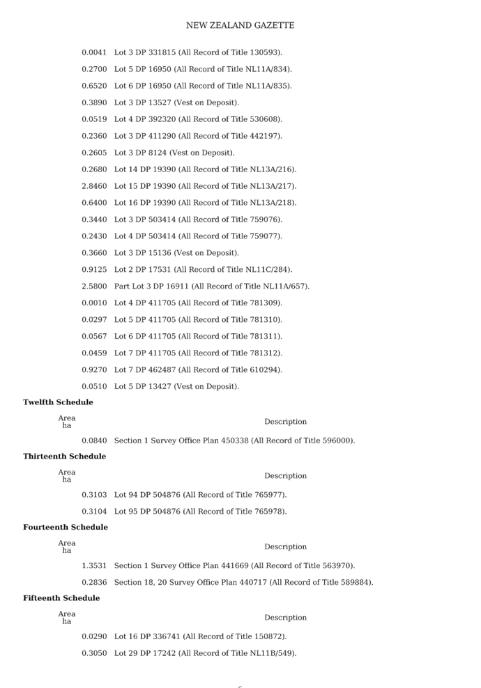
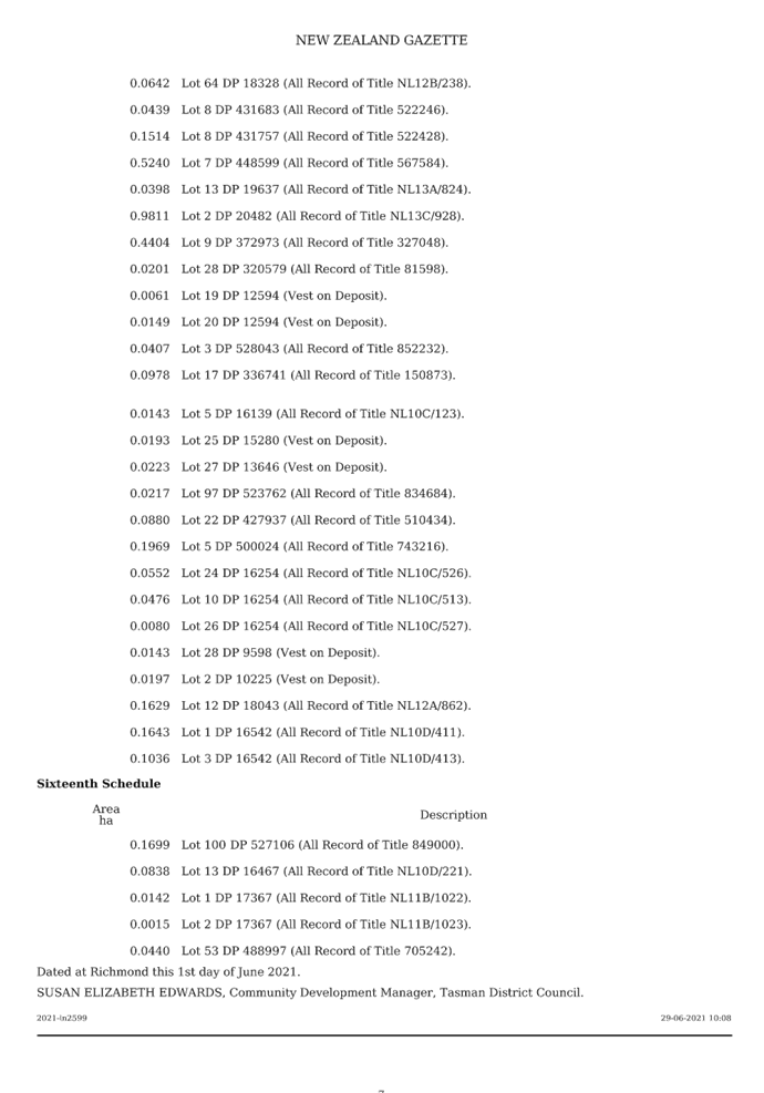
 Strategy and Policy
Committee - 30
September 2021
Strategy and Policy
Committee - 30
September 2021
9.6 Climate Change Update
Information Only - No Decision
Required
|
Report To:
|
Strategy and Policy
Committee
|
|
Meeting Date:
|
30 September 2021
|
|
Report Author:
|
Anna Gerraty, Senior
Community & Reserves Policy Advisor; Julie Nguyen, Graduate Community
Policy Advisor
|
|
Report Number:
|
RSPC21-09-6
|
1.1 This
report provides a progress update on implementation of the Tasman Climate
Action Plan (Action Plan), along with climate change updates in brief at the
regional, national and international level.
1.2 Cabinet
has agreed to begin consulting on the national Emissions Reduction Plan in
early October and to extend the date for finalising this Plan out to May
2022. Consultation will take place over a six-week period.
1.3 The
international update section notes that the latest report from the
Intergovernmental Panel on Climate Change was released in August.
That
the Strategy and Policy Committee receives the Climate Change Update report
RSPC21-09-6.
3.1 This
report provides:
· a
brief update on the Tasman Climate Action Plan; and
· climate
change updates in brief at the regional, national and international level.
4.1 The Action Plan was adopted by Council at a Full Council meeting on
12 September 2019 (RCN19-09-11). The Action Plan contains three focus areas and
actions under four goals.
4.2 An internal working group, comprising of 12 staff from across
Council, meet bimonthly to ensure the Action Plan progresses.
5 Update
on progress with implementing the Tasman Climate Action Plan
5.1 The
following table highlights progress on some of the projects contained within
the Action Plan. A more detailed annual report on implementation of the Action
Plan will be presented to the 11 November 2021 Strategy and Policy Committee
meeting.
|
Goal
|
Target
|
Action
|
Status
|
Progress
Update
|
|
1. Council contributes to New Zealand’s efforts to
reduce GHG emissions (incl. net carbon emissions).
|
1(a) Council's emissions* of methane reduce by 10% below
2017 levels by 2030 and 47% by 2050 or earlier. Council's net emissions* of
all other greenhouse gases reduce to zero by 2050.
|
(iii) Facilitate
and support a higher number of strategically located EV charging
stations and electric bike docks/charging stations across the District.
Continue to increase the number of plug-in
hybrid vehicles in Council’s fleet and investigate use of electric
vehicles.
|
Progressing
|
Council’s
vehicle fleet currently includes seven hybrid cars, but no electric vehicles
(EVs) as yet. Staff are assessing options for potential purchase of
Council’s first EV.
The LTP
2021-2031 has no budget for installing EV charging stations at our service
centres or elsewhere in the District. Installing a slow charger at our
service centres to charge fleet vehicles would cost approximately $5,000. A
rapid charger for public use is estimated to cost $30,000. Council was
committed to sticking to the debt cap for Tasman’s 10-Year Plan, and
the initial suggestion to include a generic fund of $35,000/year for electric
bike and EV charging stations around the District did not receive enough
support.
ChargeNet is
currently working on rolling out EV charging stations across the highways of
Aotearoa at ‘road trip gaps’. It is not considering any local
road networks at present.
|
|
1. Council contributes to New Zealand’s efforts to
reduce GHG emissions (incl. net carbon emissions).
|
1(a) Council's emissions* of methane reduce by 10% below
2017 levels by 2030 and 47% by 2050 or earlier. Council's net emissions* of
all other greenhouse gases reduce to zero by 2050.
|
(vi) Continue to work with communities to plant
trees (e.g. riparian margin restoration, habitat enhancement, land
stability, planting in Council parks and reserves and within
some roading corridors, expand Council nursery production), to
sequester carbon.
|
On track
|
Over the time
period September 2020 to September 2021, Council has planted over 85,000
plants and trees. This includes planting undertaken for the Waimea Inlet Jobs
for Nature project, our River Planting Programme, planting undertaken by
Reserves and Facilities, Catchment Enhancement Fund plantings, and the
Marahau-Otuwhero revegetation project.
|
|
1. Council contributes to New Zealand’s efforts to
reduce GHG emissions (incl. net carbon emissions).
|
1(a) Council's emissions* of methane reduce by 10% below
2017 levels by 2030 and 47% by 2050 or earlier. Council's net emissions* of
all other greenhouse gases reduce to zero by 2050.
|
(viii) Investigate energy efficient design and renewable
energy options for Council buildings and activities.
|
On track
|
The new Motueka Library will have
solar photovoltaic and a rainwater capture system. The solar panels have been
installed and both systems will be connected this November.
The Brightwater Water Treatment
Plant has a solar photovoltaic system in place. There are plans to extend
this to other water treatment plants and wastewater treatment plants as
funding becomes available.
Other energy efficient projects
currently underway:
1. In six months, we will trial an
ultra-high efficiency electric motor at the Brightwater Water Treatment Plan.
From an energy efficient perspective, this is important as 60-70% of the
electricity used by the Council is related to water or wastewater, and almost
all of that is pumping-related. Each pump is powered by an electric motor. If
the trial is successful, for above ground pumping, we will likely switch our
standard pump motor to one of these ultra-high efficiency motors.
2. We have purchased one power quality
meter which has motor analysis capability. This will help us check that our
electric motors are running as efficiently as possible.
3. Staff are continuing
to work through a prioritised list to reduce electricity used by our
wastewater and water treatment plants.
|
|
1. Council contributes to New Zealand’s efforts to
reduce GHG emissions (incl. net carbon emissions).
|
1(a) Council's emissions* of methane reduce by 10% below
2017 levels by 2030 and 47% by 2050 or earlier. Council's net emissions* of
all other greenhouse gases reduce to zero by 2050.
|
(ix) Implement the Joint Waste Management
and Minimisation Plan (WMMP), to reduce total waste to landfill.
This plan includes new options for achieving overall reduction (e.g.
promotion of circular economy, education, service
changes etc).
|
Progressing
|
Staff are working with Nelson
City Council (NCC) to divert construction waste from landfill. This work is
possible with the Ministry for the Environment's (MfE) Waste Minimisation
Fund. The ‘Breakfast for Builders’ event has been postponed due
to the Covid-19 lockdown. The plan is to engage with the sector first before
implementing any trials to achieve reduced construction waste to landfill for
reuse.
This year we have promoted
reuseable cups and recycling car seats. We have, and will continue, to
promote our composting voucher with an informative video on composting, Love
Food Hate Waste content, Second Hand Sunday, FutureFit, and ShareWaste (a
compost sharing collective).
The most recent Second Hand
Sunday had positive engagement, with over 1,500 residents from Nelson and
Tasman seeking out information on the event, and over 600 downloads of the
list of participating addresses. The most recent Second Hand Sunday had 60
survey participants, with 16 people saying they were made aware of the event
via our Facebook page.
Once we are at a lower alert
level, we plan to promote the event waste grants and the national campaign,
RefillNZ.
|
|
1. Council contributes to New Zealand’s efforts to
reduce GHG emissions (incl. net carbon
emissions).
|
1(d) Use of transport (e.g. walking, cycling etc) as a form of
transportation increases year on year.
|
(i) Continued investment in new and
(maintenance of) existing active transport networks.
|
On
track
|
During the past quarter no new cycle lanes have been constructed
within the District. Staff have recently received direction from councillors,
and are developing Council’s Draft Walking and Cycling Strategy for
consultation with the public.
Staff have been working with
developers to ensure that more developments are better connected. A good
example of this is in Richmond West where we have added in around 7 km of new
shared pathways.
The Kohatu to Tapawera section of
Tasman’s Great Taste Trail has recently been completed. There are a few
sections of the Trail staff are considering for improvement, but the current
state of the Trail does not prevent people from using those sections of the
Trail. Staff are working on a detailed design for the Tapawera to West Bank
section. This will be the final section, which will complete the loop.
|
|
2. Tasman District becomes more resilient to the impacts
of climate change.
|
2(b) New coastal development and infrastructure accounts
for climate change risks, including sea level rise.
|
(i)
The Coastal Hazard mapping and plan change programme continues to
completion; including consideration of the extent of the risks, options and
regulatory responses for adaptation, relocation, coastal structures
etc.
|
On
track
|
The Coastal Management Project is
in Phase 3 of its work programme. The focus is on how we can respond to sea
level rise and coastal hazards by identifying high-level options that enable
us to adapt. The options are grouped into four categories –
accommodate, protect, avoid, and retreat. Community engagement is being
undertaken between 6 September and 15 October and includes updated website
pages, publication of a high-level coastal management options report, and
three interactive webinars in late September. Feedback is being sought via an
online feedback form, virtual feedback board, and hard copy forms. On
completion of this engagement, all feedback will be summarised into a report
and published on our website. This information will be used to inform next
steps in the work programme. This will focus on considering specific options
at the local level around Tasman, including respective costs, benefits,
and potential adverse effects - and which of these are acceptable.
|
 Strategy and Policy
Committee - 30
September 2021
Strategy and Policy
Committee - 30
September 2021
Nelson Tasman
Climate Forum
6.1 Since
the last report, the Nelson Tasman Climate Forum has hired an Activity and a
Communication Coordinator. The Forum is currently advertising for a Project and
Funding Coordinator. The funds for this new role come from Nelson City Council
(NCC).
6.2 We
have provided the Forum with $2,000 towards venue hire this year for its
monthly hui. The Forum is appreciative of this one-off grant from the Council.
6.3 The
Forum is working on becoming more focused and organised:
· the
Leadership Group has started developing a process to coordinate climate related
submissions to local and central agencies on behalf of the Forum;
· to
date, the Leadership Group has finalised six indicators for success for the
Forum, including around its internally-focused ‘Weaving Plan’, and
the ‘Climate Action Book’ for governing bodies, communities,
businesses and individuals;
· a
new format to the monthly hui is being trialled, with allocated time for
updates from any participant at the hui on an area of interest (e.g. art,
youth, science etc);
· groups
in the Forum are working on 16 active projects, including a repair café,
education through workshops and at schools, and letter writing campaigns; and
· work
is underway to attract more youth participation. The Forum is engaging with
principals and teachers around the region, it is dedicating a ‘youth
spot’ for young people to participate in discussions at the September
hui, and organising a Forum event just for young Nelson-Tasman residents.
Nelson
City Council
6.4 A
draft NCC Climate Action Plan was discussed at a NCC Environment and Climate
Committee workshop in July. The draft Plan shows all the resources allocated to
climate change projects over the next ten years, as set out in NCC’s Long
Term Plan 2021-2031. The actions in that draft Plan cover a wide range of
infrastructural, social and environmental areas.
6.5 A
wastewater heat mapping study has been completed that outlines how much energy
is potentially available for recover and reuse heat in various parts of Nelson
City.
6.6 NCC
is continuing to compile information for its operational carbon footprint
emissions inventory. The inventory supports the monitoring of NCC’s
progress with its greenhouse gases emissions (GHG) reductions.
6.7 NCC
is also leading the establishment of a working group to estimate the community
GHG emissions based in the Global Protocol for
Communities. The group will include members of the Nelson Tasman
Climate Forum (from its Science, Technology & Research Group), as well as
support from the Nelson Regional Development Agency. NCC staff have invited our
Council to participate in this project, to create a community carbon footprint
for both the Nelson and Tasman regions.
7.1 The
diagram on the following page outlines how the Zero Carbon Framework provides
the tools to manage New Zealand’s transition to a low-emissions and
climate-resilient future. The Climate Change Response Act (2002) was amended in
2019 to include this new legislative framework.
Emissions Reduction Plan
7.2 The
Climate Change Response Act 2002 requires the Government to prepare emissions
reduction plans setting out how New Zealand will meet emissions budgets, which
will act as stepping-stones (or interim targets) towards our 2050 emissions
reduction targets.
7.3 Ministry
and agency officials are considering the first package of advice to the
Government from the Climate Change Commission and are preparing New
Zealand’s first Emissions Reduction Plan (ERP), which was due to be
finalised by the end of 2021. Cabinet has subsequently agreed to begin
consulting on the ERP in early October and require that the final plan be
released by the end of May next year, in line with the 2022 Budget.
7.4 In
a press release dated 15 September, the Minister of Climate Change, James Shaw,
explained that “Cabinet’s decision allows organisations and
communities key to the Emissions Reduction Plan’s success to focus on
getting through the worst of the COVID outbreak before engaging with the plan.
The plan will be developed with input from iwi/Māori, Pacific
communities, business, NGOs, local government, and communities all over the
country. Notifying them now of our timeline for consultation gives them time to
prepare the resources they need to engage fully. It is only right to make sure
everyone has the chance to contribute without the additional challenge of
keeping people safe while the country is at different alert levels, especially
those in Auckland who are still at level 4. It also allows the Government to
align the final plan with Budget 2022, so people can see how its delivery will
be supported through Government investment.”
7.5 The
press release also included the following information:
Ø Since the final advice of
the independent Climate Change Commission was published in June, conversations
have been underway across Government about how Ministers and agencies can
support emissions reductions in their portfolios - and what can be included in
the final ERP.
Ø There is still work to do
to make sure New Zealand is able to meet its emissions budgets and the
Government wants to hear people’s ideas so they can inform the
conversations that continue across Government. The six-week consultation will
also invite feedback on the role different sectors can play in meeting the emissions
budgets - and what they need from the Government to support change in their own
area.
Ø While the Government has an
important role to play in getting the policy and regulatory settings right, it
cannot do so alone. Building a low-emissions economy is a collective effort. It
is true to say that some of the necessary changes can only be
Ø made if they are supported by policy or
regulatory change. But that is not always the case. The final emissions
reduction plan will need to reflect this. The end of May deadline for the final
ERP will require a legislative change.
7.6 The
final ERP will set out the policies and strategies New Zealand will take to
meet the country’s first emissions budget. It will aim to reduce
emissions and outline ways to mitigate the impacts that reducing emissions will
have on people, along with targeted policies for specific sectors (transport,
building and construction, agriculture and forestry, waste, and energy). It
will also set direction for how future emissions budgets will be met.
National climate change risk
assessment for New Zealand
7.7 In
August 2020, MfE published the first national climate change risk
assessment for New Zealand. This risk assessment, a requirement of the Climate
Change Response Act 2002, provides an overview of the most urgent climate
change risks for New Zealand. It helps the Government identify where it needs
to prioritise action and is an important step towards making New Zealand more
resilient. The risk assessment:
· gives
the first national picture of the risks New Zealand faces from climate change;
· identifies
43 priority risks covering all aspects of life from our ecosystems and
communities to buildings and the financial system;
· groups
risks according to five value domains: natural environment, human, economy,
built environment, and governance;
· identifies
the 10 most significant risks that require urgent action in the next six years
to reduce their impacts; and
· lays
the foundation for a national adaptation plan which will outline the
Government’s response to these risks.
7.8 The
next steps for the Government is to prepare, consult on and adopt a National
Adaptation Plan by August 2022 that will outline what New Zealand needs to do
to respond to the risks. The Climate Change Commission will monitor its
implementation and report to the MfE every two years on its effectiveness.
Local climate change risk
assessment framework
7.9 MfE
has been working with Tonkin and Taylor and representatives from local
government and iwi/Māori to develop a framework for regional and local
risk assessments. The framework establishes a foundation for consistency across
local risk assessments while providing flexibility to allow the inclusion of
local values when carrying out an assessment. MfE intended to publish the
guidance on their website in early September.
7.10 MfE
is working with LGNZ, Taituarā and Tonkin and Taylor on a rollout
programme to support the uptake and implementation of the guidance and gather
feedback from local authorities.
7.11 Staff
anticipate that preparation of a local climate change risk assessment for
Tasman District will be a substantial piece of work, requiring additional
resourcing. While we have an understanding of vulnerability to low-lying
coastal areas in relation to coastal storm inundation and sea level rise, other
climate-related risks are less well understood. These risks can be categorised
into 'value domains' and include human, economy, built environment, governance
and natural environment. Many other councils are more advanced than us in their
work on climate change risk assessments.
National Adaptation Plan –
Council preparedness for climate change impacts
7.12 Last
year, Council responded to MfE’s online survey on how reporting
organisations (central government, local government, lifeline utilities,
council-controlled organisations and state services) are preparing for the
impacts of climate change. Our responses will help to shape actions the
Government will take to support organisations to keep their essential services
going in the face of a changing climate.
7.13 MfE recently released a report on this survey: ‘Adaptation
Preparedness: 2020/21 baseline – A summary of reporting organisation
responses to the first information request under the Climate Change Response
Act 2002’. This report will form part of the evidence underpinning
the development of New Zealand’s first National Adaptation Plan. You can
read MfE’s report here: https://environment.govt.nz/publications/adaptation-preparedness-202021-baseline/. It highlights concerns and
risks to assets, ecosystems, communities, tools and funding support, and
education for decision makers and the wider community.
7.14 The
information gathered from the survey shows where MfE can direct more support to
organisations in their planning. Responses also set a baseline from which the
Climate Change Commission and MfE can measure how prepared local government and
others are to address the impacts of climate change and the effectiveness of
the actions in the Plan.
Consultation on two areas of the
emissions trading scheme
7.15 The
Government recently consulted on options for improving the New Zealand
Emissions Trading Scheme (NZ ETS), which closed earlier this month. The
consultations proposed further refinements to the NZ ETS to ensure a fair and
efficient market. One proposed improvement is to the market governance
framework of the NZ ETS, and the other improvement is reviewing industrial
allocation: the provision of free emissions units to industries considered
emissions-intensive and trade-exposed. Council did not make a submission on
either proposal.
Climate change litigation
against local government
7.16 Past
New Zealand High Court cases such as Smith v Fonterra Co-Operative Group
and Hauraki Coromandel Climate Change Action Inc v Thames-Coromandel
District Council highlight the increased risk of climate change litigation
being brought against local government. The Lawyers for Climate Action New
Zealand Incorporated (LCANZI) has recently filed judicial proceedings against
the Climate Change Commission (the Commission) and the Minister for Climate
Change, Hon James Shaw. LCANZI claim that the Commission’s final advice
to the Government was unreasonable and inconsistent with the purpose of the
Climate Change Response Act 2002. Closer to home, LCANZI has written and
expressed concern to Nelson City Council about the legality of the decision to
develop a new library on a site near the Maitai River: https://www.stuff.co.nz/environment/climate-news/300389491/legal-concerns-raised-with-nelson-council-over-library-development
8 International
updates of interest
Key messages
from the latest IPCC report
8.1 The AR6 Climate Change 2021 - Sixth
Assessment Report from the Intergovernmental Panel on Climate Change
(IPCC), released on 9 August 2021, brings together years of research
from climate scientists from around the world. The UN climate change
body (IPCC) was created to provide regular scientific assessments on
climate change, its implications and potential future risks, as well as to put
forward adaptation and mitigation options. An overview of this report and
implications for New Zealand was included in the Environment and Planning
Manager’s report to the Regulatory Committee meeting held on 9 September
2021 (RRC2021-09-04).
8.2 The
report’s ‘Summary for Policymakers’ provides a high-level
summary of the understanding of the current state of the climate, including how
it is changing and the role of human influence, and the state of knowledge
about possible climate futures, climate information relevant to regions and
sectors, and limiting human-induced climate change. Headline statements from
the summary are appended as Attachment 1.
8.3 Additional
materials and information about the report are available at: https://www.ipcc.ch/report/ar6/wg1/
and the Regional fact sheet: Australasia is available at: https://www.ipcc.ch/report/ar6/wg1/downloads/factsheets/IPCC_AR6_WGI_Regional_Fact_Sheet_Australasia.pdf.
9.1 We
will present a detailed annual report on progress with implementing the Tasman
Climate Action Plan to the 11 November Strategy and Policy Committee meeting.
9.2 During
September, MfE is due to provide guidance to councils on how to prepare local
climate change risk assessments. Once the guidance is received, staff will
scope the work programme requirements and seek direction from the Leadership
Team on how to resource this project.
9.3 Work
is underway by the Government to produce an Emissions Reduction Plan and
National Adaptation Plan. These will provide national guidance on actions to
help us contribute to limiting the increase in average global temperature to
1.5°C above pre-industrial levels and adapt to climate change impacts.
9.4 The
latest IPCC report from the world’s scientists reiterates that climate
change is human induced and warns us that time is rapidly running out to limit
warming to recommended levels.
|
1.⇩
|
Summary for Policymakers - IPCC AR6
|
226
|
Tasman District Council
Strategy and Policy Committee Agenda – 30 September 2021

Tasman District Council Strategy and Policy Committee Agenda – 30 September 2021
9.4 Action Sheet
Information Only - No Decision
Required
|
Report To:
|
Strategy and Policy
Committee
|
|
Meeting Date:
|
30 September 2021
|
|
Report Author:
|
Tara Fifield, Executive
Assistant - Service and Strategy
|
|
Report Number:
|
RSPC21-08-5
|
1.1 The
action items are attached from previous Strategy & Policy Committee
meetings.
|
That the Strategy and Policy
Committee receives the Action Sheet RSPC21-08-5;
|
|
1.⇩
|
Action Sheet - September 2021
|
229
|
Tasman District Council
Strategy and Policy Committee Agenda – 30 September 2021
Action Sheet – Strategy & Policy Committee
|
Item
|
Action required
|
Responsibility
|
Completion Date
|
Status
|
|
Meeting Date – 8 July 2021
|
|
Climate
Change Update Report RSPC21-07-04
|
Staff were requested to send the MfE webinar slides
included as Attachment 2 to the report, out to Crs in a clearer format
|
Anna
Gerraty
|
Anna sent the webinar slides to Crs on 9 July
|
Complete
|
|
Strategic
Policy, Environmental Policy & Activity Planning Report RSPC21-07-05
|
Staff to invite the local Director of Public Health to
attend a Council meeting to discuss the nitrate issue
|
Lisa
McGlinchey
|
The Director of Public Health is currently in MIQ but will
be invited to attend an upcoming meeting
|
In progress
|
|
Waimea
Dam confidential presentation
|
Staff to prepare a report for the next Full Council meeting
so that Council can make a formal decision if it wants to proceed with the
hydro option
|
Mike
Drummond
|
A report regarding this matter was included in the Full
Council agenda for 12 August 2021
|
Complete
|